
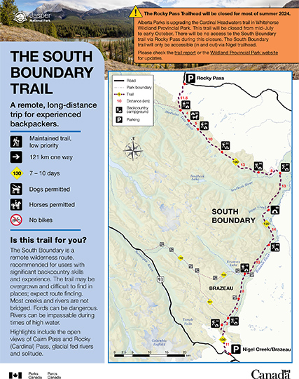
A remote, long-distance
trip for experienced
backpackers.
South Boundary trail
Jasper National Park
 South Boundary Backcountry Guide (PDF, 1.04 MB
The Rocky Pass Trailhead will be closed for most of summer 2024.
Alberta Parks is upgrading the Cardinal Headwaters trail in Whitehorse Wildland Provincial Park. This trail will be closed from mid-July to early October. There will be no access to the South Boundary trail via Rocky Pass during this closure. The South Boundary trail will only be accessible (in and out) via Nigel trailhead. Please check the trail report or the Wildland Provincial Park website for updates.The South Boundary is a remote wilderness route, recommended for users with significant backcountry skills and experience. The trail may be overgrown and difficult to find in places; expect route finding. Most creeks and rivers are not bridged. Fords can be dangerous. Rivers can be impassable during times of high water.
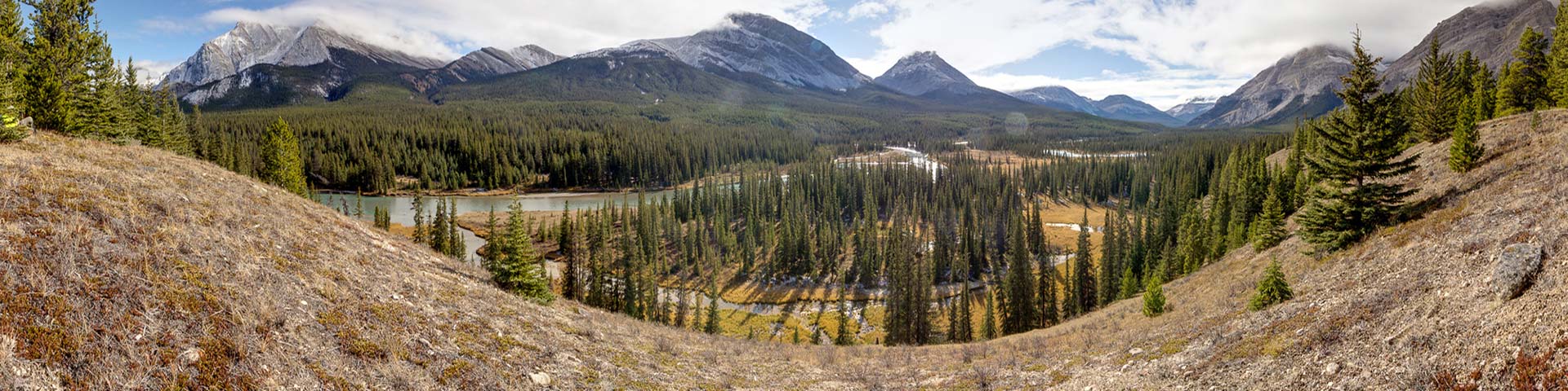
Highlights include the open views of Cairn Pass and Rocky (Cardinal) Pass, glacial fed rivers and solitude.
Planning considerations
- Maintained trail: Low priority
- 121 km one-way
- Trail #130: 7 - 10 days
- Dogs permitted
- Horses permitted
- No bikes
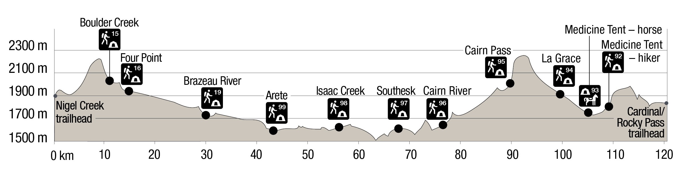
Elevation profile
The details
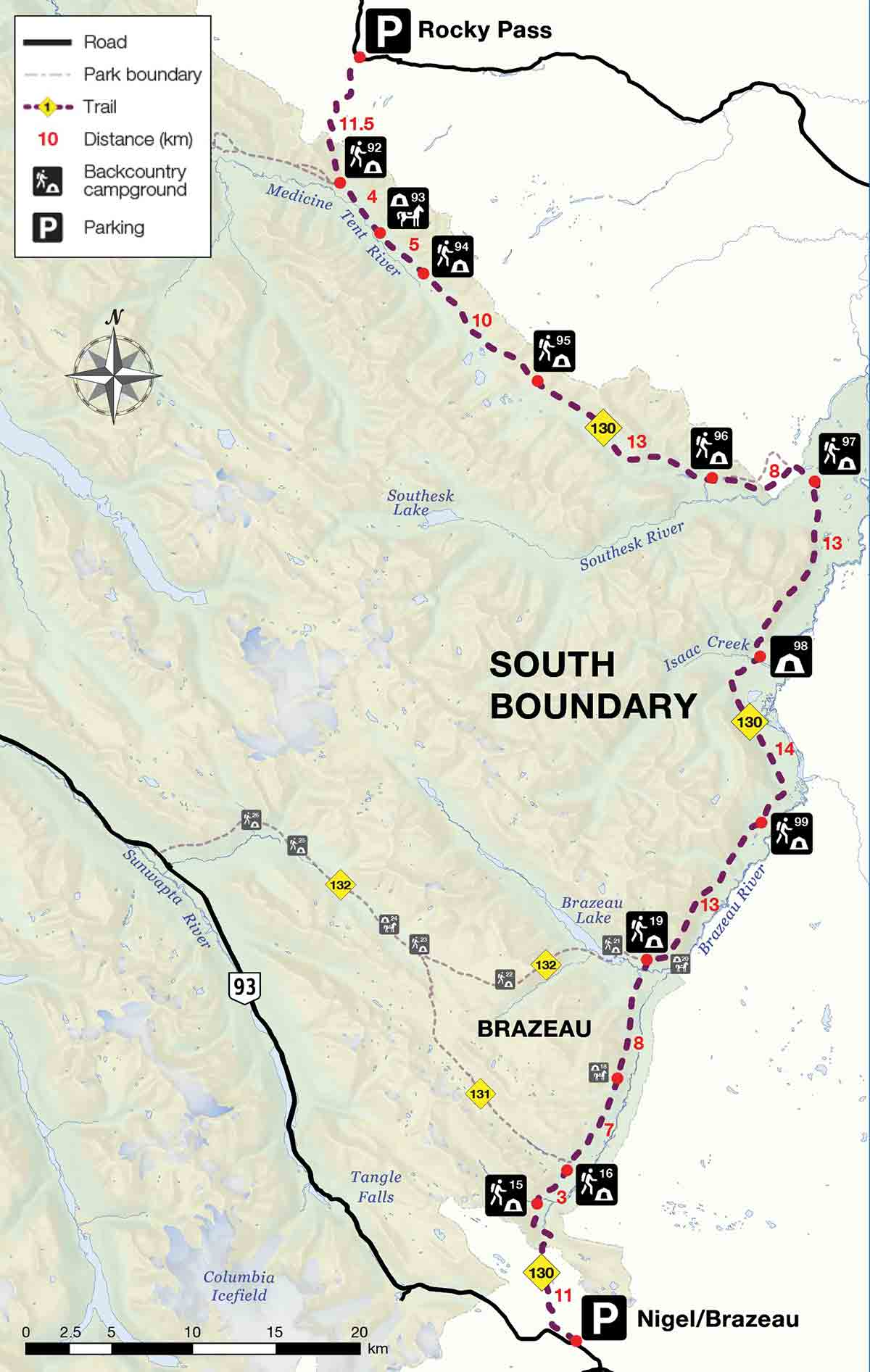
Starting at the Nigel Creek trailhead. The trail ascends to Nigel Pass to cross near the headwaters of the Brazeau River. Follow the Brazeau River past Wolverine South Horse campground (#18) to a junction near the Brazeau River Campground (#19). This first section of trail is part of the popular and maintained Brazeau Loop.
On the South Boundary trail, continue up valley to come to Arête (#99) and then Isaac Creek (#98) campgrounds. There are unbridged river crossings that may not be crossable at high water. Shortly after Southesk Campground (#97) the hiker trail crosses the Southesk River and the national park boundary on a suspension bridge. It travels outside of the park for 1.5 km before it rejoins the main trail on the north side of the river. Follow the Southesk and Cairn river valleys up to the open alpine meadows of Cairn Pass. Descend the Medicine Tent River to the junction with the Rocky Pass Trail. After crossing Rocky Pass, this trail descends to the Cardinal River. This section of trail before and after fording the river can require route finding. The trail head is just over 4 km from the river. This trail can be hiked late into the season (early October).
Note: Alternative Trailhead
Bridge near Brazeau Lake is out. Maintenance scheduled for fall 2024. Hikers may also access the South Boundary trail via the Poboktan Creek Trailhead on Highway 93. This option travels along Poboktan Creek, over Poboktan Pass and past Brazeau Lake. It joins the trail described above 2.6 km east of Brazeau Lake. The total trip distance is 116 km and takes 7 – 10 days. See Poboktan Trail Backcountry Guide for details.
History
The South Boundary Trail historically ran from Nigel Creek trailhead in the south to Beaver Lake in the north. A wildfire in 2003 and high water events have impacted the trail from Climax Creek to Jacques Lake. This section is impassable due to fallen trees, new growth, and trail damage due to slumping. Also, there is no bridge over the Rocky River north of Climax Creek. The trail is now shorter and the northern trailhead is outside of the national park over Rocky Pass.
- Watch for hiker bypass trails that split from the main horse trail at some of the river crossings. Specifically, below Four Point Campground, downstream of Arête Campground and in the Southesk area.
- Watch for re-routes and associated trail markers in areas where bridges and trails have washed out, especially between Brazeau River Campground and Cairn Pass.
- Travel is not recommended during times of high water.
- Fires are permitted only in designated fire pits.
- The distance between trailheads by road is approximately 300 km. Plan transportation.
- The names Cardinal Pass and Rocky Pass are both often used for the same pass. Cardinal Pass appears on topographical maps.
- The Brazeau and Poboktan portions of this trail are closed for caribou from November 1 to May 15.
Campground information
| Campground | Elevation | Description | # of sites | Toilet type | Food storage | UTM |
|---|---|---|---|---|---|---|
| Boulder Creek #15 |
2036 m | This campground has pretty views and is located close to the Brazeau River. | 4 | Throne | Lockers | 11U 492962 5790100 |
| Four point #16 |
1935 m | A forested campground close to the Brazeau River with nice views. The junction for Jonas Shoulder is just after this campground. | 8 | Throne | Lockers | 11U 494770 5792240 |
| Brazeau River #19 |
1737 m | A rustic forested campground close to the Brazeau River. | 4 | Throne | Lockers | 11U 499608 5804813 |
| Arete #99 |
1647 m | A simple camping area in the forest high on a bank above the Brazeau River. | 4 | Bar | Pole | 11U 506649 5813317 |
| Isaac Creek #98 |
1605 m | A simple camping area in a small meadow with some mountain views. | 4 | Throne | Lockers | 11U 506581 5823234 |
| Southesk #97 |
1590 m | A pretty camping area on the shore of a small lake with mountain views. | 4 | Bar | Pole | 11U 509593 5833803 |
| Cairn River #96 |
1673 m | A beautiful camping area on the shore of the Cairn River with mountain views. | 4 | Bar | Pole | 11U 502779 5834066 |
| Cairn Pass #95 |
2074 m | A pretty camping area on the edge of a meadow with mountain views. | 4 | Throne | Pole | 11U 493151 5839715 |
| La Grace #94 |
1940 m | A simple camping area on the edge of a meadow with some mountain views. | 4 | Bar | Pole | 11U 486511 5846015 |
| Medicine Tent – Horse #93  |
1773 m | A simple horse camping area across the Medicine Tent River from the main trail. | 4 | Bar | None | 11U 482937 5849194 |
| Medicine Tent – Hiker #92 |
1721 m | A small camping area in the forest on the shore of the Medicine Tent River. | 4 | Bar | Pole | 11U 480791 5851834 |
How to get there
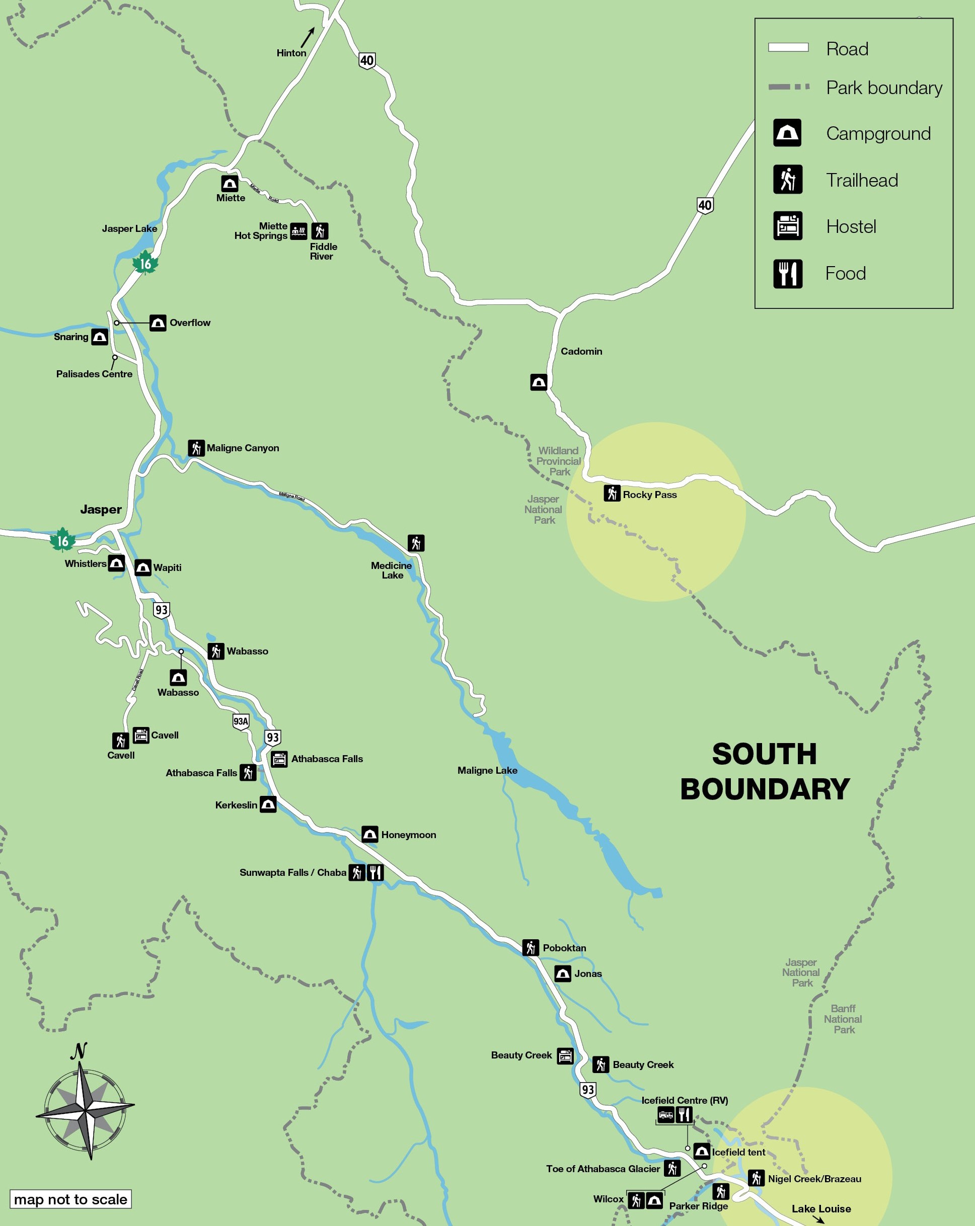
Nigel Pass
- 116 km south of Jasper on the Icefields Parkway.
Rocky Pass
Note: This trailhead will not be accessible mid-July through early October of 2024. Use the Nigel Creek trailhead.
This trailhead is located outside of Jasper National Park on Forestry Trunk Road 734. Total one-way distance is approximately 150 km with the last third on gravel road.
- Take Highway 16 North from Jasper toward Hinton.
- Just before Hinton, turn south onto Highway 40. Continue through the hamlet of Cadomin.
- Ascend to the summit of Cardinal Divide and down 1.7 km on the other side to the trailhead parking lot on the west side of the road.
Are you prepared?
Safety is your responsibility
Refer to the Jasper National Park Backcountry Planning Guide:
- descriptions of trail types and campground facilities;
- equipment checklists;
- responsible camping practices;
- safety information.
Before heading out, check trail, weather and road conditions at: parks.canada.ca/jaspertrails.
Maps
| 1:50,000 | National Geographic |
|---|---|
| Medicine Lake 83C/13 Mountain Park 83C/14 Southesk Lake 83C/11 George Creek 83C/10 Job Creek 83C/7 Sunwapta Peak 83C/6 Columbia Icefield 83C/3 |
Jasper South |
Permits
A backcountry camping permit is mandatory for all overnight trips and can be obtained online at reservation.pc.gc.ca or by calling 1-877-737-3783.
Related links
- Athabasca Island
- Athabasca Pass
- The Brazeau Loop
- Celestine Lake to Rock Lake Trail
- Fiddle River Trail
- Fryatt Trail
- Saturday Night Lake Loop
- Jacques Lake
- Maligne Lake
- Skyline
- Tonquin Valley Trail
- Random camping
- Little Heaven – Upper Blue Creek
- Maligne Pass
- The North Boundary Trail
- Jonas Pass-Poboktan Creek
- Bivouacking guidelines
- Horse use in Jasper National Park
- Date modified :