
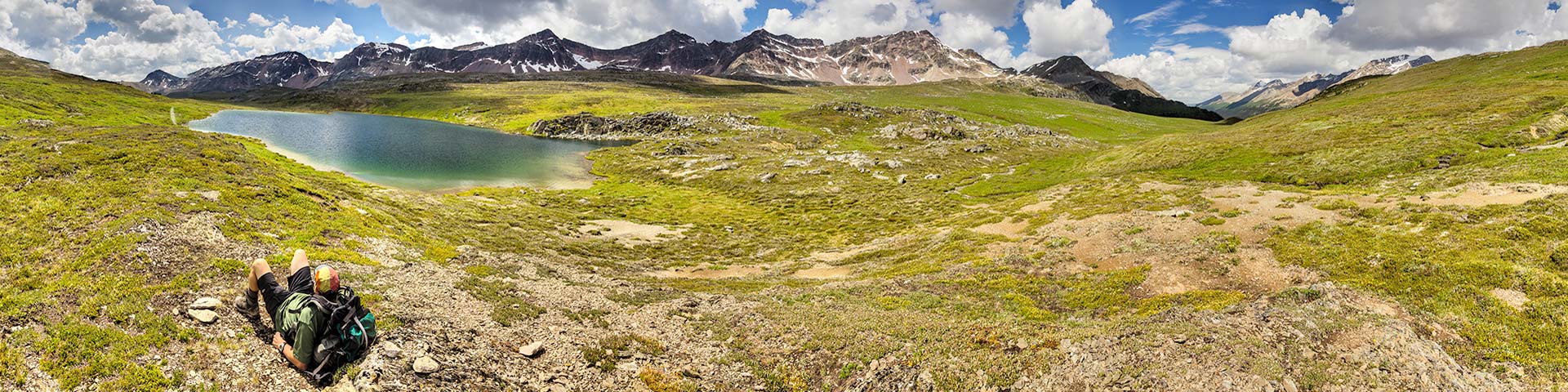
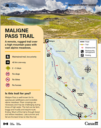
A remote, rugged trail over a high mountain pass with vast alpine meadows.
Maligne Pass Trail
Jasper National Park
 Maligne Pass Backcountry Guide (PDF, 2.7 MB)
Maligne Pass is well known for its spectacular wildflowers and incredible alpine meadows. River crossings are necessary and may be challenging during times of high water. The trail can be faint, boggy and muddy and require route finding. Much of the trail is through forest and willow meadows. Late summer and fall are the best times to hike this trail.
Planning considerations
- Maintained trail: low priority
- 48 km one way
- Trail #160: 2 - 3 days
- No dogs
- No bikes
- No horses
The details
Starting from the Poboktan trailhead, the trail to Avalanche Campground (#100) steadily climbs 6 km up Poboktan Creek trail to the junction with the Maligne Pass trail. At this junction you will head north (left) up the Poligne Valley. The trail crosses Poligne Creek numerous times on a series of small bridges. These bridges are prone to wash outs and may be damaged. The trail levels out shortly before Avalanche Campground (#100) on the west side of the valley. Approximately 4 km further along an often boggy trail brings you to incredible views of Maligne Pass and an alpine lake. Beyond the pass, the trail descends to the Maligne River, requiring fords to get to Mary Vaux Campground (#101). From here, the trail can be faint with significant deadfall. Further river fords will be required. Continue down-valley through forest and willows past Schäffer Campground (#102), Trapper Creek Campground (#103) and finally to the trailhead at the end of the Maligne Lake Road.
- Maligne Pass is high elevation. Snow can remain until late in the season.
- River fords are necessary, which can be challenging during high water.
- This trail is maintained with low frequency; watch for bridge washouts and poor sightlines.
- This area supports a high density of wildlife. Ensure safe practices while hiking and camping.
- Dogs are not permitted. This trail travels through woodland caribou habitat.
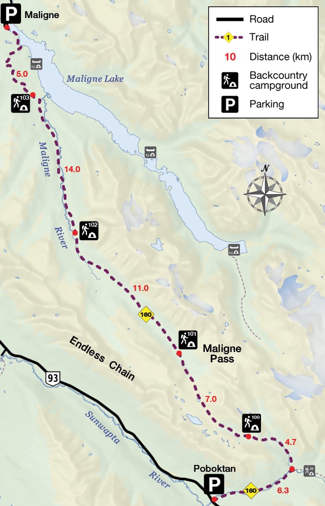
Distance to campgrounds
From Poboktan trailhead (one way)
- Avalanche: 11 km
- Mary Vaux: 18 km
- Schäffer: 29 km
- Trapper Creek: 43 km
Campground information
| Campground | Elevation | Description | # of sites | Toilet type | Food storage | UTM |
|---|---|---|---|---|---|---|
| Avalanche #100 |
2082 m | A beautiful campsite with great views, next to a creek. | 1 group (max 6 people) | Throne | Cable | 11U 472219 5815430 |
| Mary Vaux #101 |
2002 m | A basic camping area along the trail. | 1 group (max 6 people) | Throne | Cable | 11U 467374 5821347 |
| Schäffer #102 |
1804 m | A basic camping area along the east side of the Maligne River. | 1 group (max 6 people) | Throne | Cable | 11U 461150 5828622 |
| Trapper Creek #103 |
1724 m | A basic camping area along the trail. | 1 group (max 6 people) | Throne | Pole | 11U 457838 5837902 |
How to get there
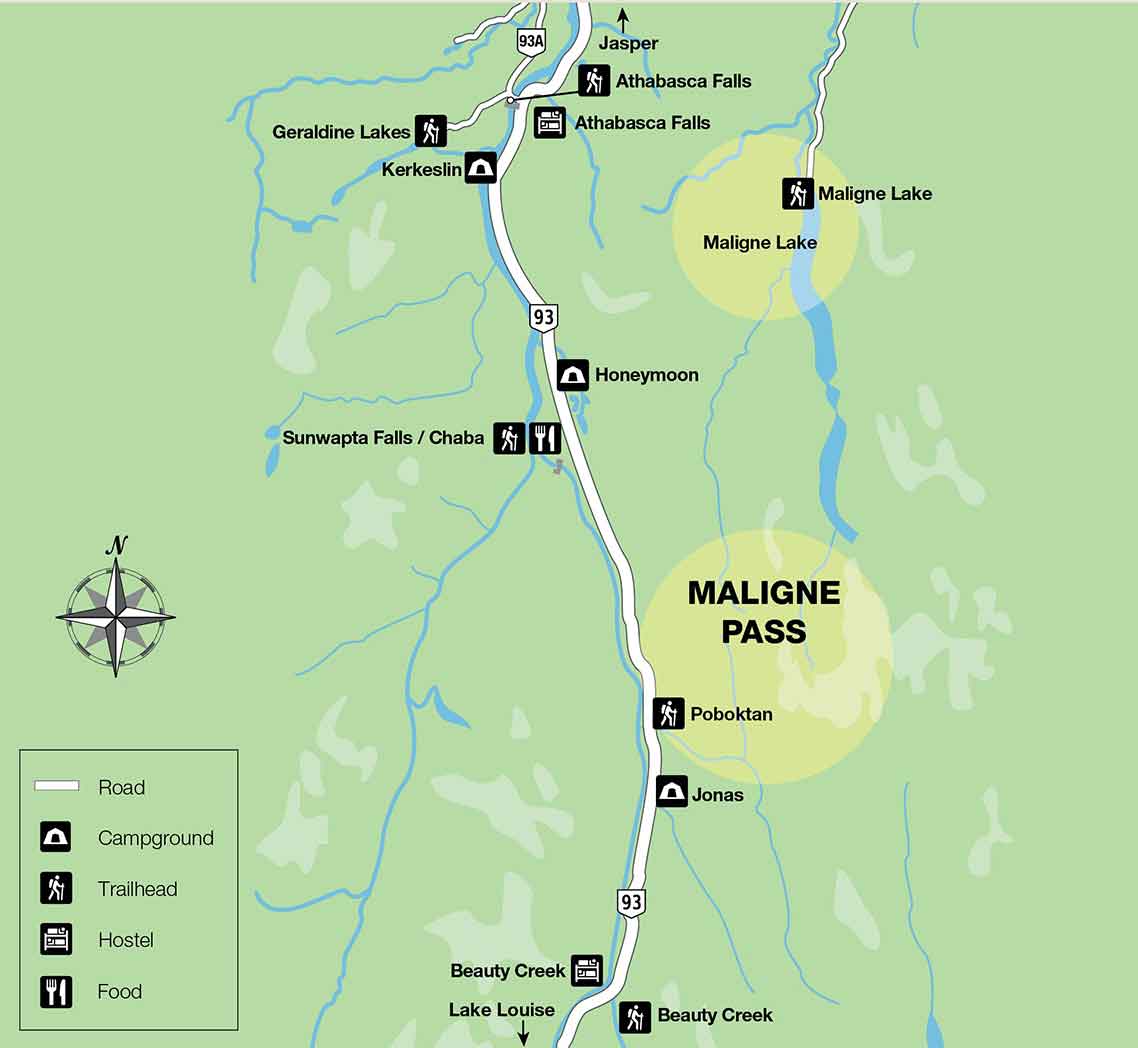
From Jasper
- Travel 75 km south on Highway 93.
- Just after Sunwapta Station you will cross a small bridge across Poboktan Creek. Turn into the parking lot on the left.
- The trail itself starts behind Sunwapta Station.
Are you prepared?
Safety is your responsibility
Refer to the Jasper National Park Backcountry Planning Guide:
- descriptions of trail types and campground facilities;
- equipment checklists;
- responsible camping practices;
- safety information.
Before heading out, check trail, weather and road conditions at: parks.canada.ca/jaspertrails.
Maps
| NTS | National Geographic | Gem Trek |
|---|---|---|
| Sunwapta Peak 83 C/6 | Jasper South | Jasper and Maligne Lake |
Permits
A backcountry camping permit is mandatory for all overnight trips and can be obtained online at reservation.pc.gc.ca or by calling 1-877-737-3783.
Related links
- Athabasca Island
- Athabasca Pass
- The Brazeau Loop
- Celestine Lake to Rock Lake Trail
- Fiddle River Trail
- Fryatt Trail
- Saturday Night Lake Loop
- Jacques Lake
- Maligne Lake
- Skyline
- Tonquin Valley Trail
- Random camping
- Little Heaven – Upper Blue Creek
- The North Boundary Trail
- Jonas Pass-Poboktan Creek
- South Boundary trail
- Bivouacking guidelines
- Horse use in Jasper National Park
- Date modified :