
Across the river
Jasper National Park
These trail routes lie on the east side of the Athabasca River, across from town. Reach them by going east on Highway 16 for 1.9 km to the Moberly Bridge, or south on Highway 93A for 0.6 km, then left to cross the river on the Old Fort Point bridge.
Old Fort Point loop
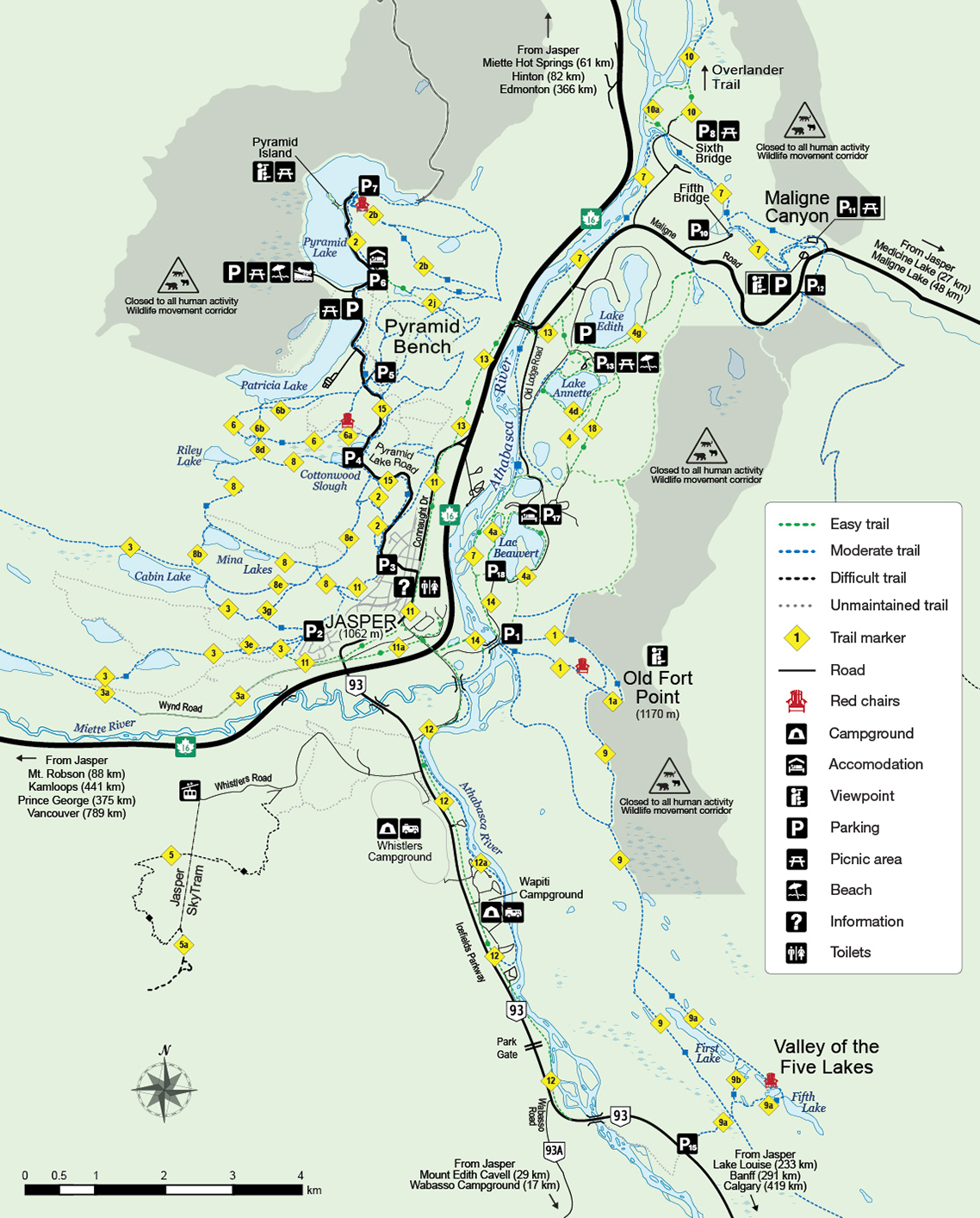 Map A: Around Town (PDF 2.225 MB)

Trail 1 and 1a (moderate); 3.8 km loop; 130 m elevation gain; 1-1.5 hours
Trailhead: From town or from Highway 16, follow Highway 93A to the Old Fort Point/Lac Beauvert access road. Turn left, cross the Athabasca River on the old iron bridge, then park in the lot on the right. Distance to the trailhead from town: 1.6 km.
Old Fort Point is a prominent bedrock hill standing 130 m above the river. Rounded on its south side, cliffy on its north side, Old Fort Point is a classic roche moutonnée: a bedrock knob shaped by glaciers. The loop trail over the top is steep in places, but it provides an excellent view of Jasper and its surroundings.
The name Old Fort probably refers to Henry House, a North West Company cabin built near here in 1811, now gone but commemorated as a National Historic Site.
The quickest route to the big view at the top of the hill is up the stairs that start by the cliff. (The stairs lead to a Canadian Heritage Rivers plaque about the Athabasca.) But it's a steep climb. Instead, we recommend the wide, easy path that begins behind the trail information kiosk. Follow Trail 1 up a short hill and on through the woods.
At 1.3 km you climb a very steep section 30 m of elevation gain in a short distance beside an outcrop of the oldest rock in Jasper National Park. The layer is Precambrian, about 750 million years old. Take a close look at this unusual rock. It's breccia, made of angular chunks of pink limestone.
Here's what you can see from the top of Old Fort Point on a good day, viewing clockwise: Mt. Edith Cavell (always snow-streaked) to the south, The Whistlers (mountain with the tramway terminal near the top) to the southwest, the valley of the Miette River leading west toward Yellowhead Pass and B.C., the town of Jasper across the Athabasca River, the reddish quartzite of the Victoria Cross Range to the northwest beyond the town (the peak with a microwave relay station on top is Pyramid Mountain), Lac Beauvert and Jasper Park Lodge to the north (other lakes visible northward: Annette and Edith), the gray limestone of the Colin Range to the northeast, rounded Signal Mountain and the cliffs of Mt. Tekarra to the east, and to the southeast, Mt. Hardisty (sloping layers) and Mt. Kerkeslin (layers bowed gently down).
The Overlander trail
Trail 10 (moderate); 15.5 km one way; 65 m elevation gain; 5-6 hours
Trailhead: Sixth Bridge, 7.5 km east of Jasper via Highway 16 and the Maligne Road.
One of the park’s signature trails, this route passes by an early valley homestead and through prime montane habitat.
Maligne Canyon Closed until further notice.
Trails 7g and 7 (moderate); 2.1 km one way; 1-2 hours
Trailhead: Fifth Bridge, 8 km east of Jasper via Highway 16 and the Maligne Road.
The Maligne Canyon section of Trail 7 provides the best views of Jasper's famous limestone gorge. Cross the suspension bridge over the Maligne River and keep right at all intersections as you work your way up the canyon, gaining 100 m. (You can start at the top and walk down the canyon trail, but the views are better if you're facing up-canyon.) Water gushes from springs along the way; interpretive signs explain how Maligne Canyon is connected to Medicine Lake, 15 km away, by a cave system.
Keep right at Second Bridge, leaving Trail 7 to follow the short un-numbered interpretive path past the spectacular waterfall at the head of the canyon to the main parking lot.
Lake Annette loop (Clifford E. Lee)


Trail 4d (easy); 2.4 km return; no elevation gain; 1-1,5 hours
Wheelchair Accessible
Trailhead: Take Highway 16 east for 1.9 km and turn right onto the Maligne Road. Angle right onto Lodge Road, then turn left at the sign for Lake Annette. Keep right at major intersections to reach the western parking lot for the Lake Annette picnic area. The trail begins on the right side of the lot.
This short loop trail is newly paved and wheelchair friendly. Bicycles are not allowed. There are wheelchair-accessible toilets available and signs placed at wheelchair height explaining the scenery.
- Date modified :