
Parks Canada / B. Morin
Miette Hot Springs area
Jasper National Park
Vehicle size restrictions for Miette Road
Maximum length 7.5 meters (25 feet)
Miette Road is narrow and winding. Trailers and large motorhomes not permitted past Miette Campground. Trailer drop-off in Lower Miette Mine Trail Parking lot.
If you like to hike in the park's high country, you normally have to wait until mid-June for the snow to go except in the Miette Hot Springs area, where the trails are usually clear by late May, when the road to the hot pool opens. It closes in mid-October. Check with park staff for exact opening and closing dates.
Take Highway 16 east toward Edmonton for 42 km, then turn right toward Miette Hot Springs. The 17-km Miette Road is narrow, winding and scenic; you might want to stop at the Ashlar Ridge Viewpoint at 8.9km. This road is also renowned for black-bear sightings. If you do see a bear, stay in your car and never, ever offer a bear any food. Food-habituated bears quickly create serious problems. They can be relocated, but usually they keep returning and often must be destroyed. As the wardens say, A fed bear is a dead bear.
Bighorn sheep are present in the pool area all summer long. They are used to being around people. Feel free to observe and photograph the sheep, but don't feed them.
Mine Trail
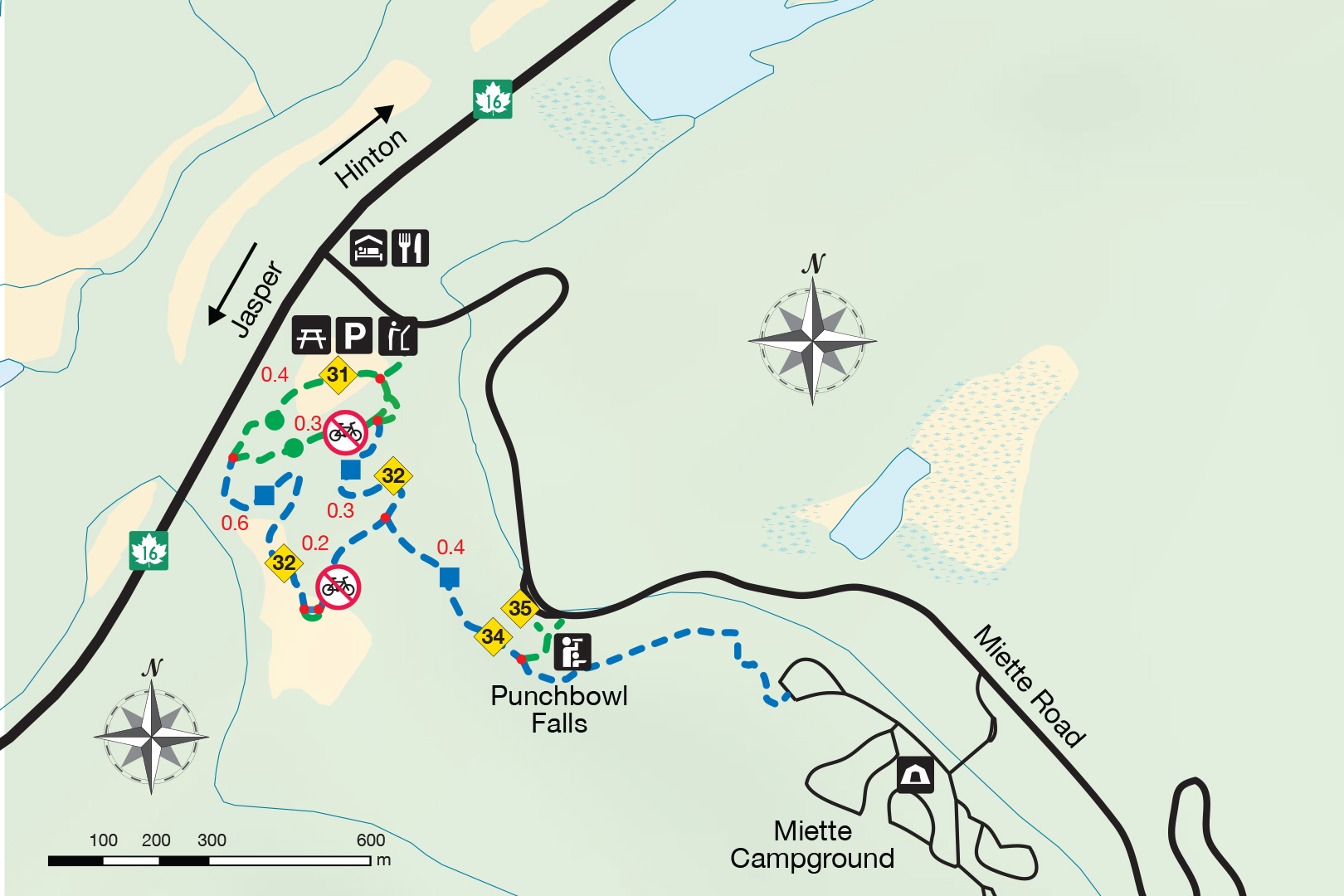
Trail 31 (easy); Lower loop: 900 m; 20 minutes
Trailhead: On Miette Road, 200 m from the intersection with Highway 16
Step back in time as you stroll through the old Mine site. This route can be lenghtened by following trail 32.
Trail 32 (moderate); Upper loop: 1.7 km; 45 minutes
Trailhead: On Miette Road, 200 m from the intersection with Highway 16

Jasper House Viewpoint

Trail 33 (easy); 700 m return; 20 minutes
Trailhead: 32 km northwest of Jasper on Highway 16
Source of the Springs
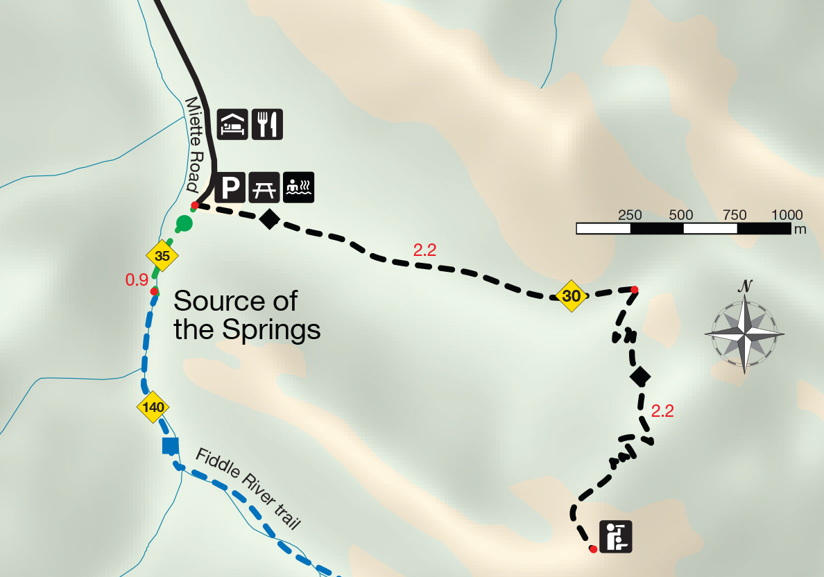
Trail 35 (moderate); 1.2 km return; elevation gain/loss: 75 m; 30 min
Trailhead: Miette Hot Springs parking lot
The trail begins with a walk through the ruins of the old pool building and continues up the creek to the hot springs themselves.
Sulphur Skyline

Trail 30 (difficult); 8.8 km return; 700 m elevation gain; 4-6 hours
Trailhead: Miette Hot Springs parking lot. Park in the pool lot and walk up the steps toward the entrance, where there is a passenger drop-off loop. A wide paved path branches from the loop, leading uphill past the trailhead information kiosk.
If you'd like to reach the summit of a peak, take this challenging trail. The total elevation gain is nearly 700m. You climb steadily across on open mountainside for 2.2 km to Shuey Pass, elevation 1815m, where the trail splits. Take the right branch. The trail switchbacks up, angles across another open slope and arrives at the treeline, where you pass a large boulder of white quartzitea glacial erratic that was carried all the way from the Jasper area during the ice ages. Here the well-graded trail becomes a steep, stony path. Keep going; you'll reach the summit of the mountain, elevation 2050 m, sooner than you might think. Guard your lunch here. The golden-mantled ground squirrels that live among the summit rocks are very bold!
The view is spectacular. To the east you can see right over the mountain front and across the foothills. The gravelly valley of the Fiddle River winds to the southeast; Utopia Mountain (2563 m) and other gray limestone peaks of the Miette Range are close by to the south and west, and the great cliffs of Ashlar Ridge line the valley to the north.
Caution: This area is well-known for afternoon thunderstorms. Start early, and stay below the treeline if the weather looks threatening.
- Date modified :