
Parks Canada / A. Greenberg
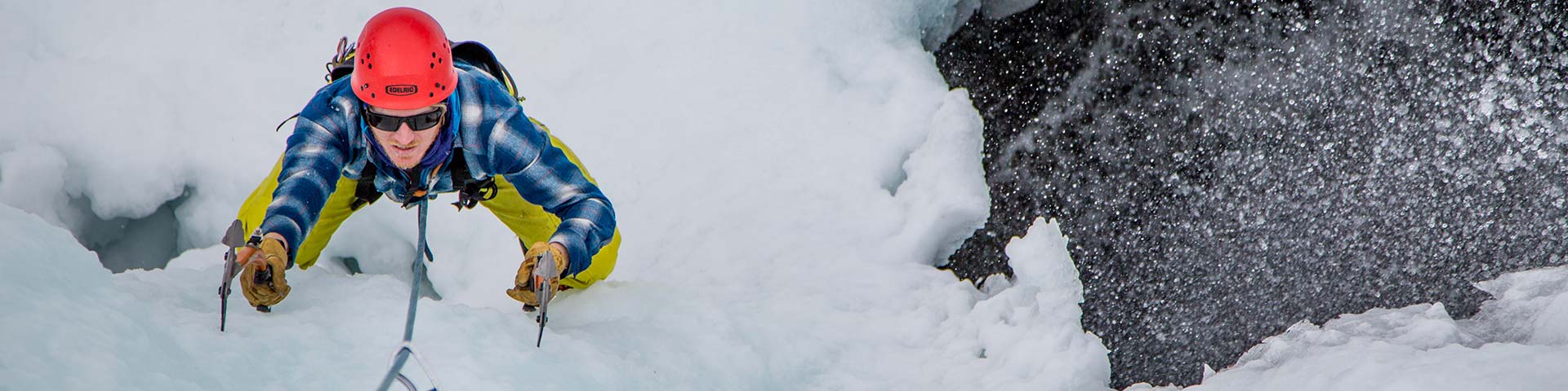
Climbing and Mountaineering
Jasper National Park
The Lay of the Land
Four national parks; Jasper, Banff, Yoho and Kootenay, as well as several provincial parks contain a vast portion of the central Canadian Rockies. Jasper National Park includes a huge section of the range from the crest of the Continental Divide along the British Columbia - Alberta border on the west, to almost the edge of the prairies on the east.
Local climbers distinguish between the higher, often glaciated alpine ranges along the continental divide, and the slightly lower, drier ranges to the east. The Yellowhead Highway provides the main east-west route through the park and access to the town and services of Jasper. The Icefields Parkway is an excellent highway that parallels the main Divide Range from Jasper in the North to Lake Louise in the south. Along the way are some of the most spectacular alpine peaks and glaciers on the continent.
How's the rock?
Climbers coming here for the first time may not be familiar with the type of climbing and the varying rock quality in particular. The Rockies are made up almost entirely of sedimentary rock including limestones and dolomites, shales, and silicas (including quartzite - metamorphic rock). The characteristics vary widely from the very worst to some fine rock, depending on the formations (the layers) encountered. The best rockclimbing is found on the some of the thickly bedded limestones (such as Roche Miette) and the beautiful quartzites located along the main continental divide ranges.
Sportrock sites are limited to accesible areas of high quality quartzite, and waterworn limestone. Alpine climbs inevitably involve climbing through multiple formations, and highly variable rock some of which is extremely loose, as evidenced by the huge talus and scree slopes around the bases of most peaks. Terms used to describe some of these more interesting layers include: shattered, tottering, chipshale, briquettes, and occasionally even simply "dirt!" (to use some of the polite terms). Locals understand that contending with these sometimes horrific conditions, is 'part of the game', and considerable skill can be required to manage the risks. Most routes do involve at least some climbing on loose rock and for climbers not accustomed to this, this can slow progress down considerably. In addition, route finding can be difficult as routes are often convoluted and indeed, routefinding is often the key to successful execution of a route. Consequently it is sound advice to approach difficulty, length grades and time estimates conservatively. Hardware for most multipitch routes and all technical alpine routes should include at least a few pitons as well as the usual assortment of nuts and camming devices.
What to do and when
The rock climbing season can begin as early as May, as the cliffs at the lower elevations along the east side of the park begin to dry off. As well, a number of 8000' peaks near Jasper town, in the Colin Range, can come into shape early in the season. However snow on approach trails and in some of the gullies can remain until June.
The higher alpine peaks (9000'+) only begin to come into reasonable summer condition in late June and early July as the spring avalanches taper off. The window for difficult alpine climbs is very limited. North faces rock pitches are usually only dry for several weeks in August, however, the season for alpine ice, climbs on steep ice faces and gullies extends into the cooler temperatures of September or even early October. Avalanche hazard can be a major consideration any month of the year in alpine environments.
What's popular? or where to start
There are several popular moderate scrambling peaks in the Park with non maintained climber worn trails to their summits. These include Mount Wilcox and Sunwapta Peak, both at the South end of the Park, and Hawk or Pyramid Mountain near the Jasper townsite. The Rock Gardens and Lost Boys are two sport climbing areas with numerous high quality routes consisting of limestone and quartzite respectively. Access trails to these sport climbing areas are not maintained, there may be overhead and underfoot dangers encountered along the way. Parking for Lost Boys is available at the Leach Lake Picnic Area, 100m south of the trail head, where garbage and outhouse facilities are available. Meisner Ridge, in the Colin Range near the Jasper townsite or Ashlar Ridge to the East provide challenging multipitch limestone rock climbs with spectacular views from their summits.
The Columbia Icefields is a spectacular glaciated plateau, which boasts several of the highest peaks in the Canadian Rockies. Alpinists, from the novice to the extreme, will be challenged by routes such as the Normal Route on Mt. Athabasca (II) or the Grand Central Couloir on Mt. Kitchener (V 5.9 A2/W5). The quality of the routes combined with roadside access make the Icefields an excellent area in which to focus a climbing trip to the Canadian Rockies. The North Face Mt. Edith Cavell and the Japanese Route on Mt. Alberta are two additional alpine climbs that are among of the 50 Classic Climbs in North America.
Camping and bivouacs
Camping regulations and permits are explained in the accompanying Backcountry Visitors Guide. Climbers are permitted to bivouac on long routes or otherwise where necessary to safely complete a climb. Some restrictions apply. A backcountry use permit is required and specific guidelines are available at the visitor centres where you obtain the permit.
Trip plan
Heading Outdoors? Leave a Plan.
No one ever expects to get into trouble outdoors. But, a turn in the weather, mistake in judgment, unexpected injury, equipment failure, or sudden nightfall can quickly change any recreational outing into a crisis. Does anyone know where you have gone and when you expect to return?
Completing a trip plan is extremely important. It explains your destination, travel route, equipment and expected return time. It is vital information to assist authorities searching for you in the event of an emergency.
If no one knows you are missing, no one will be looking for you.
Emergencies
Dial 911 to report an emergency. Cell phone coverage is limited within the park with some coverage existing close to the town site. Pay phones are located along the Icefields Parkway at; Saskatchewan River Crossing Warden Station, the Icefields Centre lower parking lot, Beauty Creek Hostel, Sunwapta Warden Station, Bubbling Springs pullout, Athabasca Falls Hostel and the Athabasca Pass lookout. Several emergencies have been called in using satellite phones in recent years.
Let the dispatcher know that you are in Jasper National Park (or the north end of Banff National Park) and then give your precise location and the accident location. Phones to the south of the Icefields are routed to a 911 dispatch out of Rocky Mountain House. The dispatcher will not be as familiar with the area as the Jasper and Banff Park dispatchers. The speed of the rescue response will depend on you knowing where you are.
If you are calling for assistance using a satellite phone the number to call to reach the Jasper emergency dispatch will be 780 852 3100 or 877 852 3100 depending on your service provider.
Rescue services
The Park Warden Service provides comprehensive rescue services for visitors to the National Parks. The Costs of rescues will normally be recovered from the Park User Fees paid by all visitors at the park gate. Park users should note that ambulance services, including air ambulance, are the responsibility of the user.
Maps and guidebooks
A number of guidebooks are now available and cover the range of climbing/mountaineering activities including scrambling (easy/moderate mountain climbs) rock climbing, sport rock, alpine mountaineering, ski mountaineering and waterfall ice climbing. Each of these guidebooks contains excellent introductory information specific to the activity and the area.
Local information
There are two Park Visitor Information Centres in Jasper Park, one located in downtown Jasper, the other at the Columbia Icefields Centre.
Park Wardens, particularly those in the park visitor safety program, can answer many mountaineering inquires and provide information on current conditions, when they are available. They provide a daily avalanche information bulletin throughout the winter and summer seasons as conditions require.

The Association of Canadian Mountain Guides Mountain Conditions Report (ACMG) NEW!
- Date modified :