
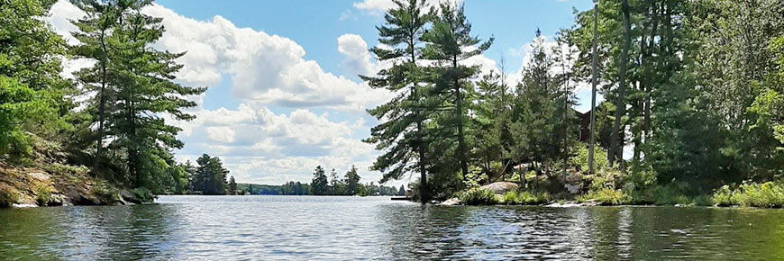
Paddling Route: McCrackens Landing to Peterborough
Trent-Severn Waterway National Historic Site
Kawarthas region 2-day route
On this 2-day paddling trip, paddle through three different paddling environments and plan an overnight’s stay in a Parks Canada oTENTik and experience camping at a new comfort level.
Route information
- Difficulty: Intermediate
- Total distance: 37 km (23 miles); one way
- Day 1 - McCracken’s Landing to Lock 24 - 23.5 km (14.5 miles)
- Day 2 - Lock 24 to Monaghan Boat Ramp - 13.5 km ( 8.5 miles)
- Time to paddle: 8 to 10 hours total
- Day 1: 5.5 to 6.5 hours
- Day 2: 3 to 4 hours
- Number of locks encountered: 9
- Environment: Lakes; Gentle river and canal
Facilities and services available along this route:
-
 Lockage (required on this route)
-
 Accessible washrooms
 Potable water
 Information
-
 Picnic area
-
 Camping
COVID-19
Some lockstation facilities and services have changed in response to the COVID-19 pandemic and could affect your visit. Please visit our COVID-19 information page for more details when planning your trip.
Lockage (required on this route) Accessible washrooms Potable water Information Picnic area CampingCOVID-19
Some lockstation facilities and services have changed in response to the COVID-19 pandemic and could affect your visit. Please visit our COVID-19 information page for more details when planning your trip.
Plan your trip
This is a one-way route that requires a personal shuttle to or from the put-in and take-out locations. Plan accordingly.
Put-in locations
Suggested:
- McCrackens Landing
Location: 2281 McCrackens Landing Rd, Lakefield, ON
Other locations to put-in nearby:
Take-out locations
Suggested:
- Monaghan boat ramp
Location: Monaghan Rd., Peterborough, ON
Other locations to take-out along this route:
- Trent University
- Steps by Bata library
- Boat launch near Peterborough Rowing Club (Nassau Mills Road)
- Top of Peterborough Lift Lock
- Bottom of Peterborough Lift Lock
- Lock 20 Ashburnham
- Beavermead Beach
- Roger’s Cove Beach and Mark St. Boat Launch
- Newhall Park
- Otonabee River Unsupervised Beach
Camping and Accommodations
Suggested:
- Lock 24 - Douro
Location: County Rd 32, Douro-Dummer, ON
- oTENTik
- Tent camping
Tent camping is available at most lockstations on a first-come, first-served basis, at the discretion of the lockmaster. Campsites can not be reserved in advance.
Learn more about camping at lockstationsPaddling directions
- Paddle left from McCrackens Landing
- Follow the west shore of Clear Lake, then the east shore of Katchewanooka Lake and the Otonabee River
- When exiting Lock 20, stick to the left shore to explore Meade Creek through Beavermead Park
- When back on into Little Lake turn left toward Lock 19
- Monaghan Rd Boat launch is located on your right (west shore)
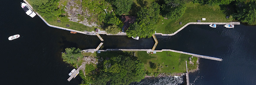
Lockage
Lockage is recommended for several locks along this route. Portaging may be difficult.
Lockage is the process of raising or lowering boats and paddlecraft into connecting sections of the Trent-Severn Waterway. Lockage takes approximately 20 minutes to complete. During seasonal Hours of Operation, paddlers can lock through any Parks Canada lock with the purchase of a valid lockage permit. Permits may be purchased upon arrival, or in advance online or by phone.
Locks along this route
The status of facilities and services at lockstations listed below are subject to change throughout the navigation season. Please visit our Facilities and Services page for up-to-date status by lockstation.
Wind conditions
- The water flows from Lakefield to Peterborough
- Preferable wind conditions are from the north / north east (tail winds)
- Avoid strong east/southeast and west/northwest winds (cross winds), especially for when crossing the lakes
- Avoid: south/southwest winds (head winds)
Hazards
- Watch for powerboats and their wake
- Winding narrow sections of the Otonabee River past Lock 19
Avoid dams
Watch for dams at the following locations and be sure to navigate away from them:
- Left (east) side of Lock 27
- Left (east) side of Lock 26
- Right (west) side of Lock 25
- Right (west) side of Lock 24
- Right (west) side of Lock 23
- Right (west) side of Lock 22
- Right (west) side of Peterborough Rowing Club
- Left (east) side of Lock 19
Tourism information
Nearby communities and services
- Young's Point
- Lakefield
- Dining and shopping within walking distance of lockstation
- Peterborough
- Dining and shopping within walking distance.
Points of interest
- Island Church called St. Peter’s on-the-Rock
- Juniper Island
- Historic pagoda & historic Juniper Island Store
- Lockside Trading Co.
- Young’s Point Conservation Area trails
- Lakefield Beach & Playground
- Trent University
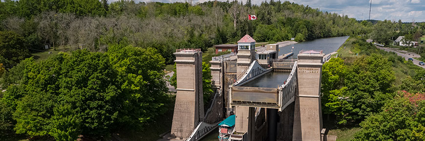
- Peterborough Lift Lock National Historic Site
- Peterborough Lift Lock and Visitor Centre
- Peterborough Museum and Archives
- Centennial Fountain on Little Lake
- Beavermead Park
- R. B. Rogers’ gravestone at Little Lake Cemetery
- Art Gallery of Peterborough
Regional tourism
The following regional tourism experts can help guide you towards great local experiences and businesses in the areas along this route. Visit their websites when planning your trip.
- Peterborough and the Kawarthas Tourism
Phone number: (705) 742-2201 or 1-800-461-6424
- Kawarthas Northumberland
- Northumberland Tourism
- City of Peterborough
- Explore Kawartha Lake
Videos
Parks Canada on Youtube
Videos by others
Other routes you might like…
- Date modified :