
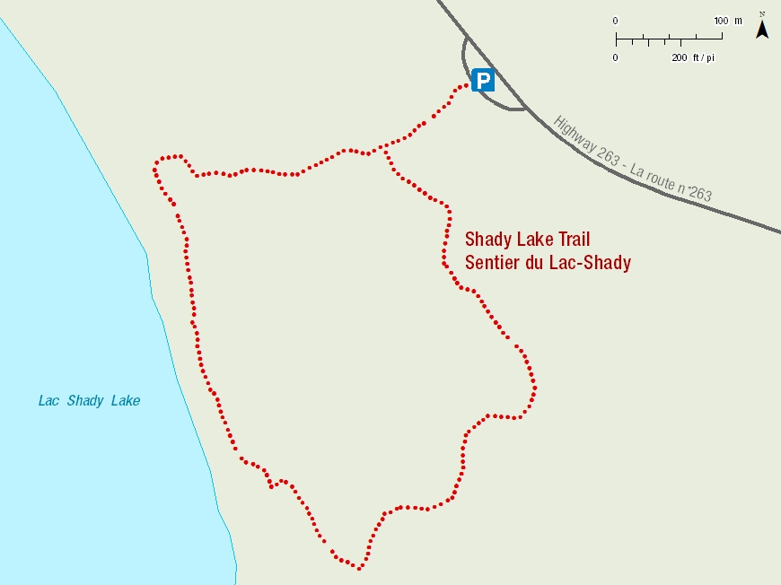
Shady Lake Trail
Prince Albert National Park
A shady descent
Descend 70 metres to a muddy mineral lick on the shore of narrow Shady Lake. Look for tracks of elk, deer and moose who come to eat minerals brought to the surface by springs. Listen for loons and grebes as you follow the trail along the grassy lake edge.
Ascend through birch and aspen, dappled gold in autumn, bright green in spring. Near the end of the trail, a 750-metre trail spur leads to Height of Land tower with a spectacular view of Shady Lake.
Length: 1.7 km, loop
Time: 40 minutes
Level of Difficulty:  Moderate, Steep hills.
Trailhead: 8km from the visitor centre on highway #263
GPS Co-ordinates for Trailhead (in decimal degrees):
Lat.: 53.87131155 Long.: -106.10459901

Related links
- Trail conditions
- Amyot Lake Trail
- Treebeard Trail
- Routes to Grey Owl's Cabin
- Fisher Trail
- Grey Owl Trail
- Hunters Trail
- Kingsmere River Trail
- Boundary Bog Trail
- Narrows Peninsula Trail
- Red Deer Trail
- Spruce River Highlands Trail
- Waskesiu River Trail
- Mud Creek Trail
- Freight Tait Springs Trail
- Height-of-Land Lookout Tower
- Valleyview Trail Network
- Elk Trail
- Date modified :