
Due to significant changes in the landscape from the 2023 Wildfire season, all recreational trails will remain closed for the 2024 season.
This is to ensure visitor safety while we work to complete the required fire rehabilitation to make these areas safe to visit.
Thank you for your understanding and for respecting all area closures. For a full list of what’s open and what’s closed, please visit https://parks.canada.ca/pn-np/nt/woodbuffalo/securite_safety/bulletins.
Wood Buffalo National Park of Canada
| Rating | Trail | Condition | Comment | Links |
|---|---|---|---|---|
| Benchmark Creek Trail | Closed. | 15-05-2024: Hazardous trees; | Trail details | |
| Grosbeak Lake Route | Closed. | 15-05-2024: Hazardous trees; | Trail details | |
| Karstland Loop Trail | Closed. | 15-05-2024: Hazardous trees; | Trail details | |
| Lakeside Trail | Partially closed, check trail details for additional information. | 08-11-2024: Stay on trail; Respect all posted notices and signs; Snow covered; | Trail details | |
| Lane Lake Trail | Closed. | 15-05-2024: Hazardous trees; | Trail details | |
| Rainbow Lakes Trail | Closed. | 15-05-2024: Hazardous trees; | Trail details | |
| Salt Pan Lake Trail | Closed. | 15-05-2024: Hazardous trees; | Trail details | |
| Salt Plain Access Trail | Winter conditions. | 08-11-2024: Respect all posted notices and signs; Snow covered; Unmaintained trail; | Trail details | |
| Salt River Meadows Loop Trail | Closed. | 15-05-2024: Hazardous trees; | Trail details | |
| Sweetgrass Station | Winter conditions. | 09-12-2024: Snow covered; | Trail details |
Day Hiking
Our trail system offers short, relaxing strolls and scenic, long loops.
Trails on Highway 5
Wetland Lookout
Stretch your legs on this short interpretive trail to a lookout, overlooking whooping crane habitat.
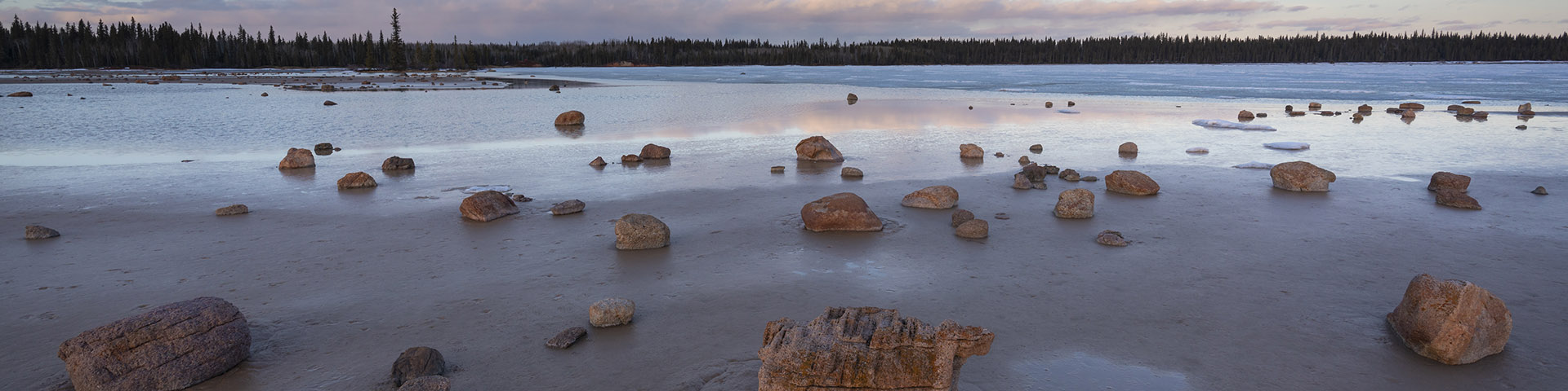
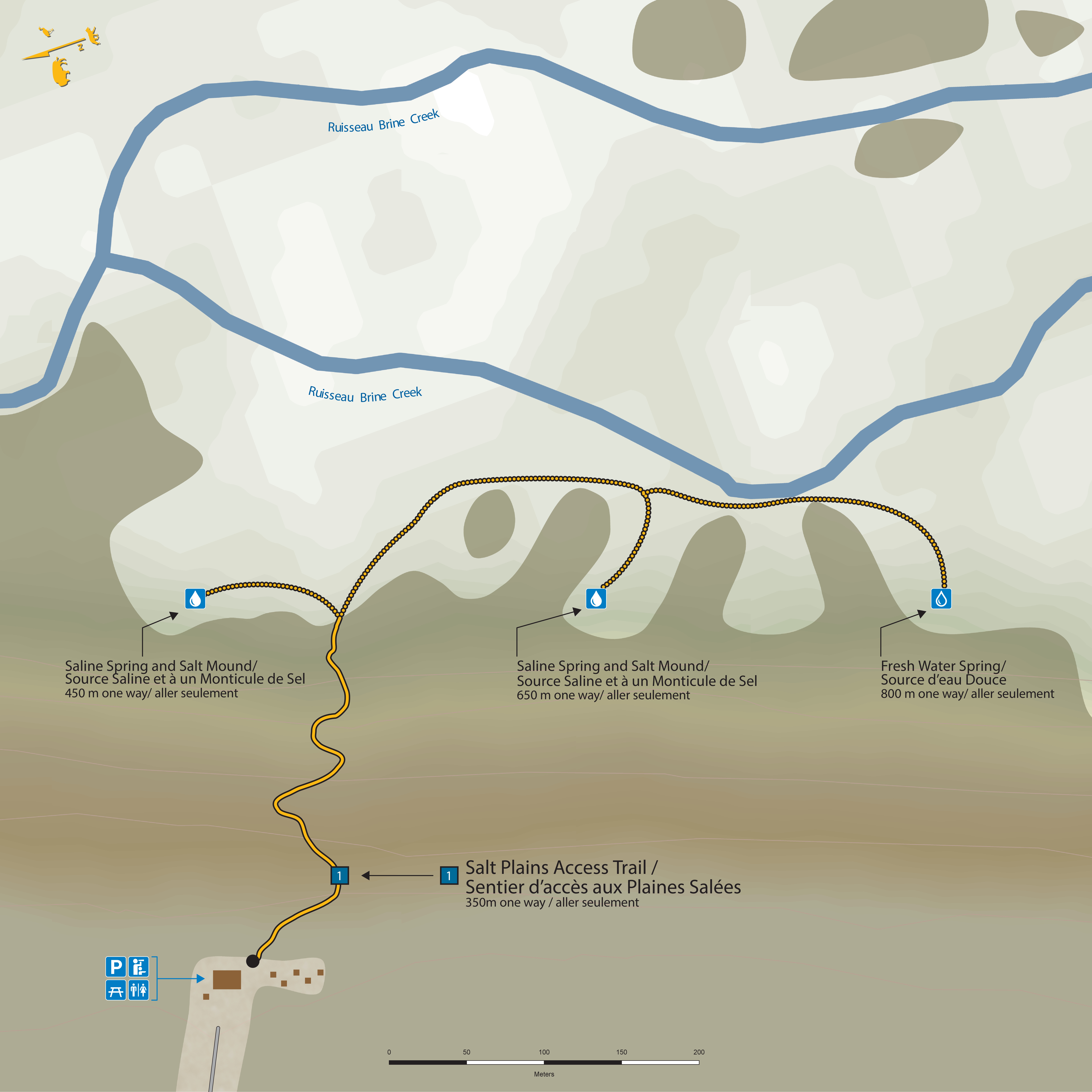
Salt Plains Access
Moderate 350 m one way, 700 m return
Make your way down a steep escarpment from the Salt Plains Viewpoint to the Salt Plains. For a hike you won’t forget, search for the spring by the treeline and walk barefoot amongst the salt mounds.
Map of the Salt Plains Access Trail
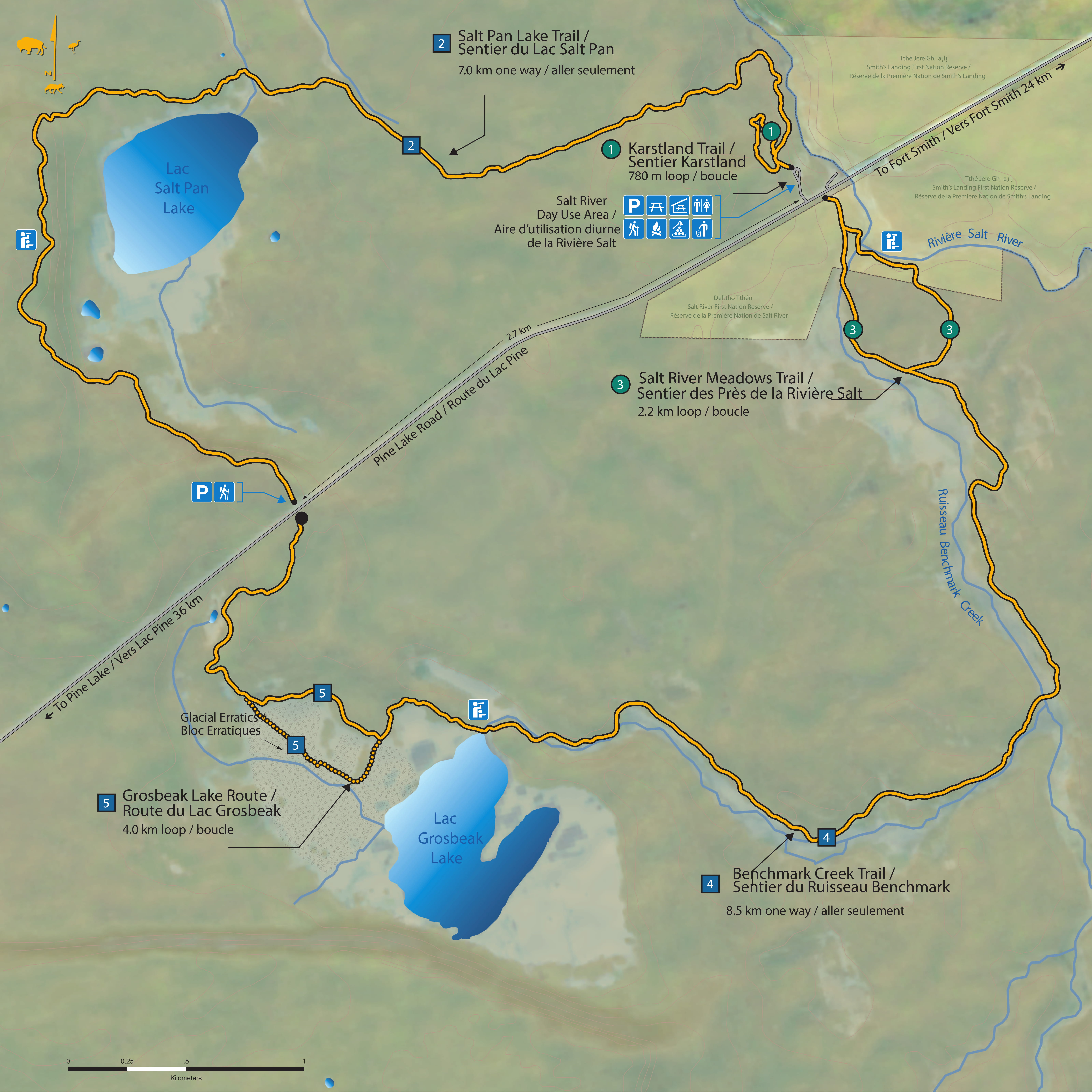
Salt River Day Use Area Trails
Map of the Salt River Day Use Area Trails
Karstland Trail
This trail is closed due to a collapsed sinkhole. We’re working on a new route.
Easy 780 m loop.
Take a boardwalk through karst and forest to views of sinkholes and access to snake hibernacula.
Salt River Meadows
Moderate 2.2 km loop
Meander side-by-side through wildflower meadows and along a saline stream. This wide trail starts across Pine Lake Road from the Salt River Day Use Area parking lot.
Grosbeak Lake
Moderate 4.0 km loop
This trail through a boulder field at Grosbeak Lake is a “must-see” site in Wood Buffalo National Park. Walk through erosion-sculpted boulders scattered across a white salt pan and to a viewpoint overlooking the lake
Salt Pan Lake
Moderate 7.0 km one-way, 14 km return
Watch for bison as you hike through karst and forest to an escarpment overlooking Salt Pan Lake. To hike a longer loop (15.5 km) combine Benchmark Creek and Salt Pan Lake Trails.
Benchmark Creek
Moderate 8.5 km one way, 17 km return
Travel along a stream, through forest, meadows, and salt flats. Take in views of the Salt River and its tributaries on your way to Grosbeak Lake. To hike a longer loop (15.5 km) combine Benchmark Creek and Salt Pan Lake Trails.
Rainbow Lake
High water levels have flooded this trail in recent years. We do not recommend hiking it at this time.
Difficult 6 km one way, 12 km return.
Make your way through wetland, an old forest fire, and towering spruce trees to Rainbow Lake. Watch for signs of bison - wallows, tree rubbings, and tracks - along your way.
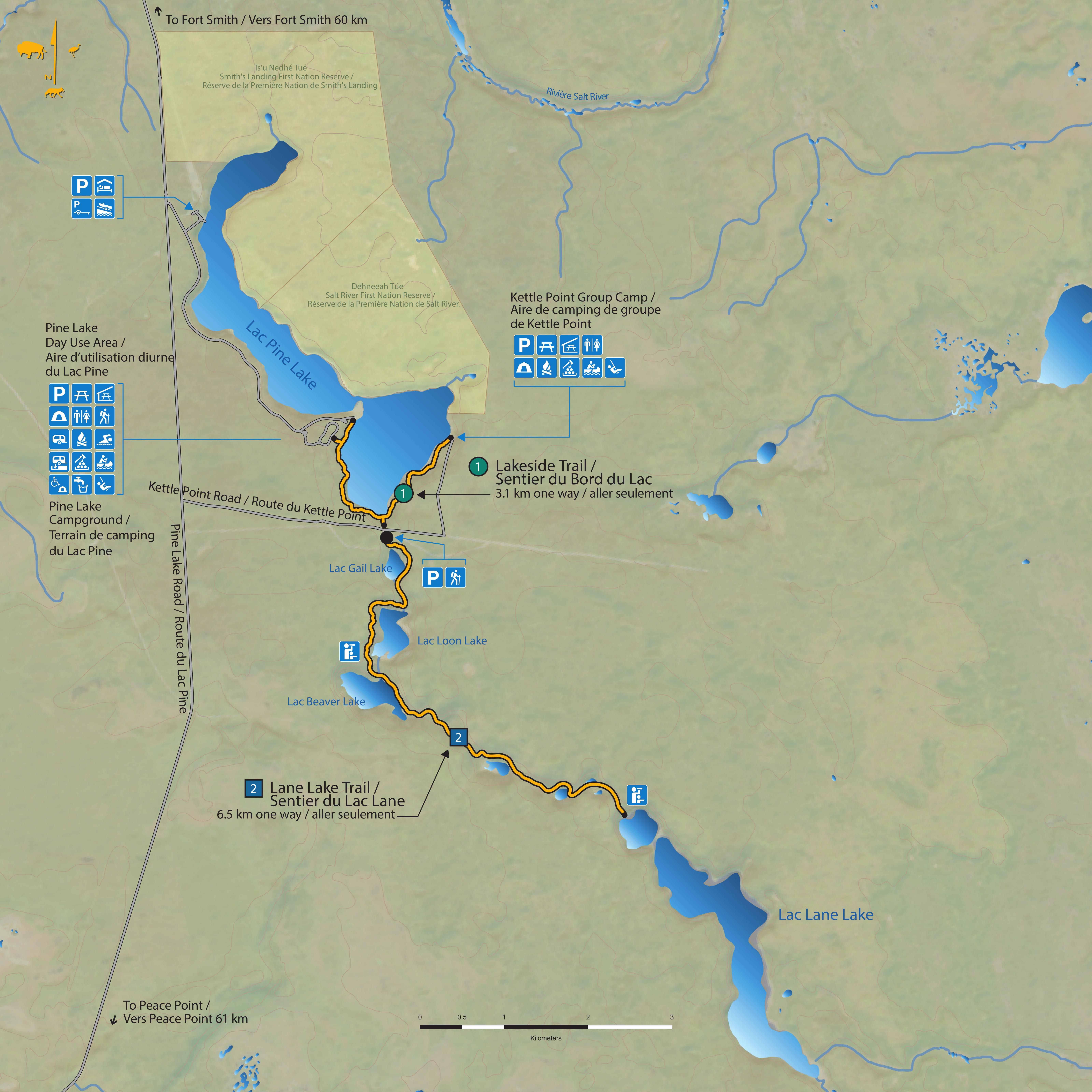
Pine Lake Area Trails
Map of the Pine Lake Area Trails
Lakeside Trail
Moderate 3.1 km one way, 6.2 km return.
Follow the shoreline through the spruce and aspen forest between Pine Lake Day Use Area and the Kettle Point Group Campsite. Part way, you can also access the Lane Lake Trailhead.
Lane Lake
Moderate 6.5 km one way, 13 km return
Follow a chain of small sinkhole lakes to Lane Lake. Watch for beavers, shorebirds, and loons. Access the trailhead from Kettle Point Road, or make a longer hike by walking the Lakeside Trail from Kettle Point Group Campsite or the Pine Lake Day Use Area.
Stay safe on the trails
A great hike is a safe hike. Here’s what you need to know to stay safe.
- Date modified :