
Wildfire risk reduction and restoration projects
Yoho National Park
Parks Canada’s fire management program is working to make the landscape in Yoho National Park healthier and more resilient. This program includes projects that lower the risk of wildfires to people and infrastructure and help bring back healthy ecosystems.
In Yoho National Park, a resilient landscape has a good mix of different ages forests. These areas have better ability to stay healthy as the climate changes and wildfire activity increases.
To reduce wildfire risk and restore these areas, we use methods such as prescribed fire, FireSmart™, hand thinning, and mechanical tree removal.
Prescribed fires
In Yoho National Park, prescribed fire season is generally April to June, and mid-August to October.
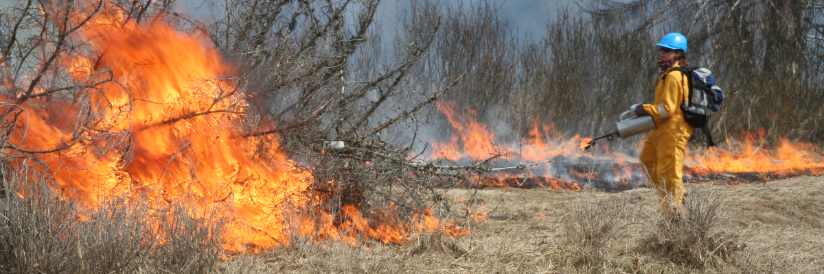
A prescribed fire is a well-planned fire that is purposely lit by well-trained fire specialists. Each prescribed fire has clear goals and can only be lit when specific conditions from the prescribed fire plan are met. Conditions include things like weather and the state of the environment. Because of this, it may take several years before the right conditions happen, and the fire can be safely lit.
2026 prescribed fire details
Updates will be available here when a prescribed fire is underway.
Approved prescribed fire plans
Float Creek
Time of year: Spring/fall
Size: 830 hectares
Location: Backcountry. Central Yoho National Park in the Ottertail Valley. Approximately 5 km east of Highway 1, 8 km southeast of Lake O’Hara, and 9 km south of Field.
Additional details: Past fire suppression has changed the natural fire cycle in the Ottertail Valley. The Float Creek prescribed fire will help bring back a young, healthy forest, which will support the overall health of the ecosystem. In addition, it will:
- help enhance important habitat for grizzly bears, which are a threatened species in British Columbia
- restore habitat for whitebark pine, which is listed as endangered under Canada’s Species at Risk Act
- create a break in fuel that can help with future fire management in Yoho National Park
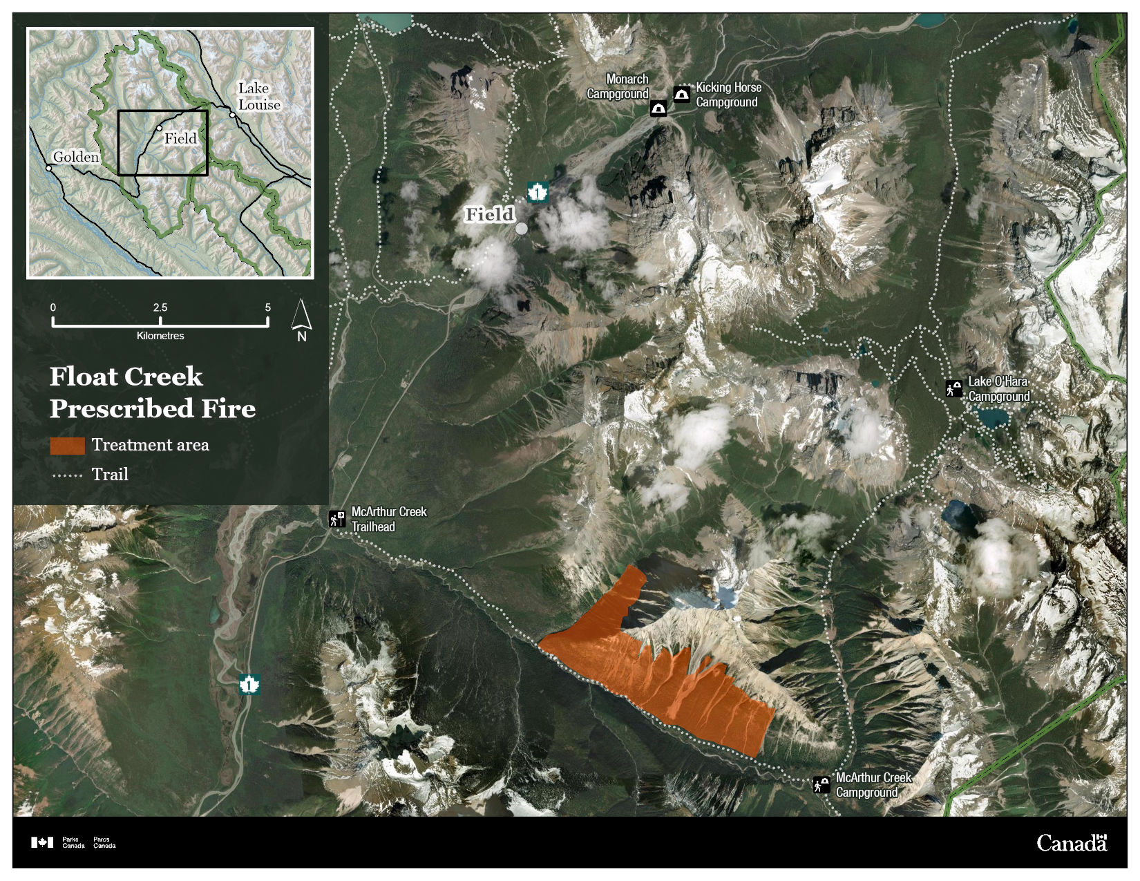
Map of Float Creek prescribed fire treatment area — Text version
This map shows the Float Creek prescribed fire unit in Yoho National Park. The main map shows a satellite-style view of the landscape, highlighting rugged mountain terrain, forested valleys, and surrounding trail systems.
An orange section on the map marks the Float Creek prescribed fire unit. This section is in Ottertail Valley, east of Highway 1, southeast of Lake O’Hara, and south of Field. Dashed lines on the map indicate trails. This includes routes leading toward locations such as the McArthur Creek trailhead, McArthur Creek Campground, and Lake O’Hara Campground. Additional landmarks—such as Monarch and Kicking Horse campgrounds—are marked to help situate the prescribed fire area within the broader landscape.
In the upper-left corner, an inset map shows the regional context, locating the prescribed fire area between Golden and Lake Louise. Directly below the inset map are a 0 to 5 km scale bar and north arrow.
The map is labeled “Float Creek Prescribed Fire” and includes an icon legend identifying the treatment area and trails. The bottom of the map has the Government of Canada black bar with the Parks Canada and Government of Canada identifiers.
Porcupine Valley
Time of year: Spring/fall
Size: 3,300 hectares
Location: Backcountry. Southwestern area of Yoho National Park in the Porcupine Valley. 17 km southwest of Field and 3 to 4 km northwest of the Hoodoos Campground.
Additional details: In 2025, Parks Canada successfully applied prescribed fire to 473 ha hectares, creating a diverse mosaic of burned and unburned landscapes. Establishing a healthy, multi-aged forest can take multiple applications over several years. As conditions allow Parks Canada plans to use prescribed fire to expand the treated area within the 3,300-hectare unit to support resilient ecosystems.
Prior to the 2025 prescribed fire, the Porcupine Valley had not experienced fire since at least 1926. Areas not burned during the 2025 prescribed fire are primarily a mature forest that is nearing the end of its historic fire cycle. Reintroducing fire into the Porcupine Valley is an important step toward restoring the benefits of fire to the landscape and meeting ecological goals in Yoho National Park.
The prescribed fire will help to:
- maintain the historic fire cycle to the Porcupine Valley
- reduce forest fuels in the area. This can help reduce wildfire intensity when they occur. With less fuel, wildfires spread more slowly and can be easier to control
- enhance habitat for grizzly bears
- restore habitat for endangered whitebark pine
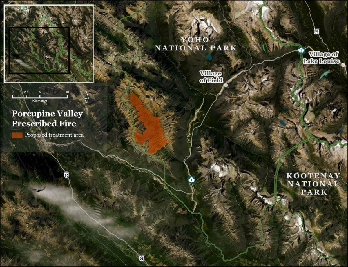
Map of Porcupine Valley prescribed fire treatment area — Text version
This map shows the Porcupine Valley prescribed fire area in Yoho National Park. The main map shows a satellite-style view. The prescribed fire area is highlighted in orange and is located southwest of Field. It sits in a mountainous, forested valley surrounded by steep peaks and rugged terrain.
The map shows that the prescribed fire area is northwest Kootenay National Park, and southwest of Field and Lake Louise. Highway 95, Highway 93, and Highway 1 are visible within the regional landscape.
In the upper-left corner, an inset map shows the regional context, locating the prescribed fire area between Golden and Lake Louise. Directly below are a 0 to 10 km scale bar and north arrow. The map is labeled “Float Creek Prescribed Fire” and includes an icon legend identifying the treatment area.
Ice River
Time of year: Spring/fall
Size: 2,986 hectares
Location: Backcountry. Near the southern boundary of Yoho National Park in the Ice River Valley. 17 km south of the Field.
Additional details: Past fire suppression has changed the natural fire cycle in the Ice River Valley. The last recorded fire in the Ice River Valley prescribed fire unit happened in 1871. This means the forest there is now 148 years old. Some areas have Engelmann spruce trees that are around 628 years old. These forests are now near the end of their natural fire cycle- a fire cycle is the natural pattern of fires happening and areas growing back over time. Because they have gone so long without burning, a prescribed fire is an important tool. It helps renew the ecosystem in a safe way, lowers the chance of very intense wildfire, and supports wildlife that needs younger forests to survive.
The prescribed fire will help to:
- restore younger forest areas in the lower subalpine zone of Yoho National Park
- support whitebark pine recovery by improving growing conditions and planting seedlings that may resist white pine blister rust
- enhance habitat for grizzly bears
- restore habitat for endangered whitebark pine
- support research for a study on how prescribed fire affects mountain goat habitat
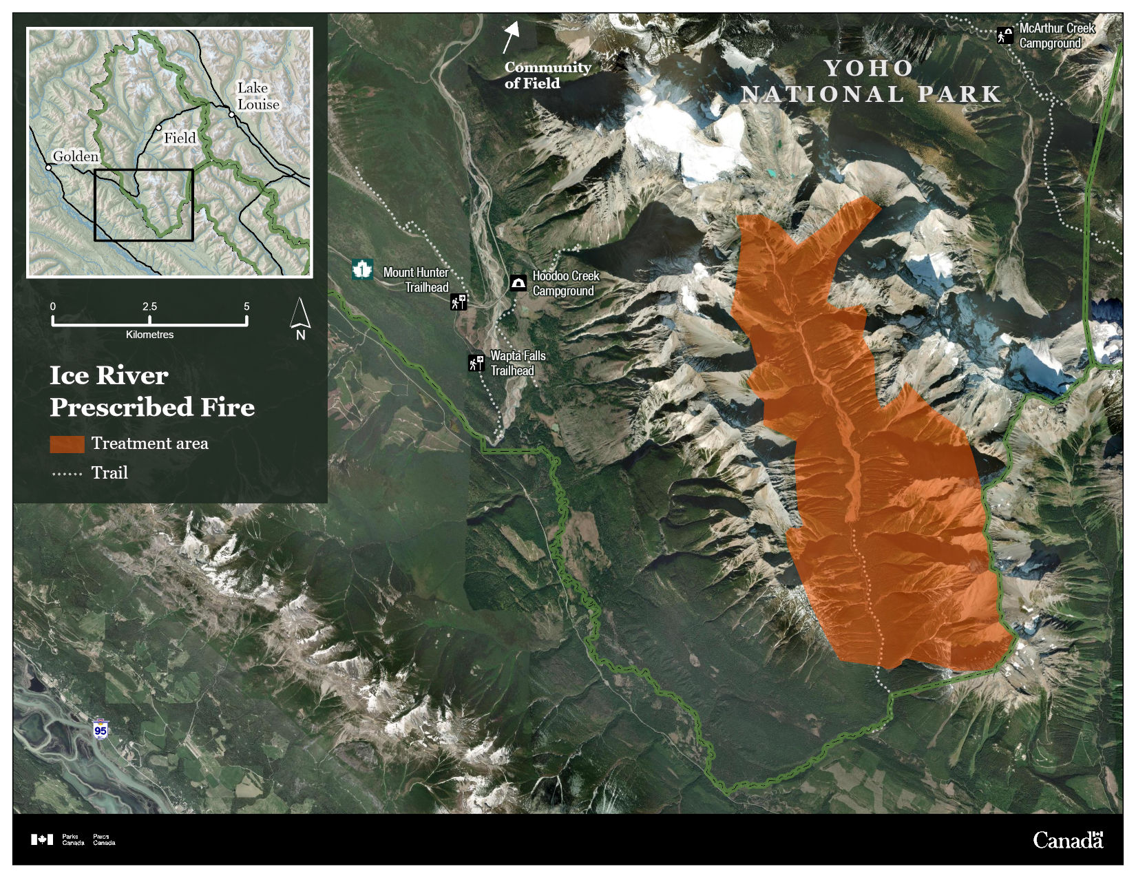
Map of Ice River prescribed fire treatment area — Text version
This map shows the Ice River prescribed fire area in Yoho National Park. The main map shows a satellite-style view. The treatment area is highlighted in orange on the right side of the map. It covers a large section of the Ice River valley, surrounded by steep mountains, glaciers, and forested slopes.
Several nearby landmarks are labeled to help viewers understand the location. These include the Field to the northeast, the Mount Hunter and Wapta Falls trailheads to the west, and the McArthur Creek Campground to the northeast. Trails are shown as dashed lines, and major park boundaries are marked with a bold dark green line.
In the upper-left corner, an inset map shows the regional context, locating the prescribed fire area between Golden and Lake Louise. Directly below are a 0 to 5 km scale bar and north arrow. The map is labeled “Ice River Prescribed Fire” and includes an icon legend identifying the treatment area and trails. The bottom of the map has the Government of Canada black bar with the Parks Canada and Government of Canada identifiers.
Prescribed fire plans in development
Prescribed fire planning is a complex process. Each prescribed fire plan can take years to complete. Once the prescribed fire plan is approved, the fire can be carried out in the same year if the weather and on site conditions are right.
Kicking Horse Meadow 1
Time of year: Spring/fall
Size: 20.3 hectares
Location: Kicking Horse Valley. 8 km south of Field and 800 m west of Highway 1.
Additional details: The Kicking Horse Meadow 1 prescribed fire is part of a larger meadows’ restoration plan. This prescribed fire will restore open meadow and grassland. It will do this by encouraging re-growth of native grass and shrub species.
The prescribed fire will help to:
- reduce the spread of conifer trees and keep a natural mix of plants in open meadow areas
- support the regrowth of native grasses and shrubs
- help restore the natural fire cycle, which normally includes low to moderate‑severity wildfires
- lower the risk of severe wildfires and help the landscape become more resilient to future fires
Ottertail
Time of year: Spring/fall
Size: 2100 hectares
Location: Central region of Yoho National Park. 3.5 km from Field and 13 kilometres east of the Yoho National Park-British Columbia boundary.
Additional details: In 2011, Parks Canada completed some sections of the Ottertail prescribed fire. The prescribed fire plan is now being updated so additional prescribed fire work can be completed.
The prescribed fire will help to:
- create a break in forest fuels on the east side of the Kicking Horse River Valley, helping strengthen fire management lines near the community of Field and the Trans Canada Highway.
- restore younger forest areas in the lower subalpine zone of Yoho National Park
- increase important food sources for grizzly bears after the fire.
Frequently asked questions
Why does Parks Canada conduct prescribed fires?
Parks Canada uses prescribed fire for two main reasons –to maintain and restore the health of ecosystems and to reduce the risk of wildfire. Parks Canada has also used prescribed fire to restore and maintain cultural landscapes and cultural resources such as archaeological sites. Prescribed fire is an important tool to remove excess vegetation that can fuel dangerous wildfires, recycle nutrients into the soil, and create habitats for plants and wildlife that depend on fire.
What goes into assessing where, when and how a prescribed fire is implemented?
Prescribed fires are complex operations that may need several years of preparation. Before a prescribed fire is set, a detailed plan – also called a prescription – is developed. It outlines very specific conditions in which the prescribed fire must meet, before being implemented. Conditions include:
- outlining the goals of the prescribed fire. Parks Canada conducts prescribed fires for two main reasons – improve the health of ecosystems and reduce the risk of wildfire
- identifying the local weather and environmental conditions, including wind direction and speed needed during the prescribed fire
- identifying mitigations to reduce impacts on the environment and on cultural sites
- determining the resources, for example personnel and equipment, needed to complete the work
- Each prescribed fire plan is peer-reviewed and requires an environmental impact assessment
Does each prescribed fire have its own plan?
Every prescribed fire requires its own detailed plan because each prescribed fire is different. Differences include the shape and size, the objectives, the fuels present, the environmental conditions and desired fire intensity. Some prescribed fires are designed to be low intensity and low complexity, such as burning grass in backcountry meadows. These fires usually make less smoke and can be finished in a day or two. Other prescribed fires are higher intensity and aim to burn most of the mature trees (stand replacing fire). These are used in areas where fire has been absent for a long time, and forest conditions are no longer following their natural cycle. These fires reduce dense, flammable trees and help a healthier, more resilient forest grow back. Although they require more planning, they also create fuel breaks in steep or remote areas where mechanical tree removal is impossible.
How is prescribed fire work carried out?
After the prescribed fire plan is approved, fire specialists wait for the right “burn window.” This very specific window appears when all the conditions in the fire plan are met.
Before lighting the prescribed fire, the National Fire Duty Officer, Field Unit Superintendent and the Incident Commander give final approval. They use a checklist to confirm that all conditions identified in the plan are met and ensure resources are in place for safety.
Depending on the plan, fire specialists may light the fire from the ground with drip torches, from the air with helicopters, or both. During operations, people can expect to see flames, smoke, equipment like sprinklers and hoses, and fire crews working in the area. Helicopters bucketing water may also take place. These are all part of normal prescribed fire operations.
Several tools are used to ensure a fire stays within its planned boundaries including:
- natural features such as lakes, rivers and avalanche paths
- man-made control lines such as fuel treatments and sprinkler systems
- ground crews and helicopters
Right after a prescribed fire, crews monitor the area closely. Fire crews action hotspots near the boundary of the prescribed fire area. Long-term checks continue for years to see if the goals of the burn are met. These goals can include creating wildlife habitat, restoring plant species, and protecting communities.
Why are prescribed fires lit when it’s hot out?
Lighting a prescribed fire when it’s hot out might seem counterintuitive, but there are strategic reasons for doing it under those conditions. Here’s why:
- Fuel moisture is low: Hot weather usually means dry vegetation, which burns more predictably and allows a cleaner burn to identified control lines, reducing the chance of escape. Prescribed fires located at higher elevations and/or in a confined valley may require higher than normal conditions, like temperature and dryness, to meet objectives. This is because fuels can be wetter than in the valley bottom and in areas sheltered by the wind. However, some environments, like meadows, have fuels that dry out quickly. This means that they require less hot and dry conditions to successfully burn and can burn in less hot periods – like the early spring or late fall. Fire specialists want fuels to be dry enough to ignite easily but not so dry that the fire is uncontrollable.
- Desirable fire behavior: In hot conditions, fire behavior can be more consistent and easier to regulate especially if humidity and wind are also within acceptable ranges. This helps crews manage the prescribed fire more safely.
- Meeting ecological objectives: Some ecosystems (like certain forest types) require hotter fires to stimulate native plant growth or clear out trees and vegetation. Historically, these areas naturally burned during periods of dry weather. Prescribed fires are now carefully planned and carried out during similar dry conditions to help copy natural fire patterns. Burning under these conditions allows fire to do its work on the land while still being safely managed.
- Wind and atmospheric stability: Hot days often come with unstable atmospheric conditions, which can help smoke rise and disperse rather than linger near the ground—important for air quality and visibility.
It’s all about balance – prescribed fires are only lit when very specific criteria (called a prescribed fire plan) are met. These include:
- temperature
- humidity
- wind speed and direction
- fuel moisture
- crew availability and safety resources
- desired time of year
How do prescribed fires affect residents and visitors in the national park?
Prescribed fires are planned to minimize impacts on people, but they can still affect residents and visitors inside and outside of the national park.
Parks Canada fire specialists make every effort to limit smoke during prescribed fire operations. Prescribed fires only go ahead if conditions allow smoke to disperse into the atmosphere. However, unpredicted changes in weather can increase and redirect smoke. Smoke can reduce visibility on sections of highways which can potentially cause delays.
Safety is always the top priority for Parks Canada in all fire management operations. During a prescribed fire, area closures are often in place until the area is deemed safe to enter.
While smoke may temporarily reduce air quality or visibility, and some areas may have restricted access, these effects are short-term and carefully managed. In the long run, prescribed fires help protect communities by reducing the risk of severe wildfires and improving forest health.
Why are you creating/adding to smoky conditions?
While prescribed fires may cause temporary smoke, they play a vital role in reducing the risk of severe wildfires — which can blanket communities in smoke for weeks or even months. Parks Canada uses prescribed fires and managed wildfire to reduce the likelihood and intensity of wildfires by reducing fuels during desirable conditions.
Wildfire risk reduction and restoration projects in nearby national parks:
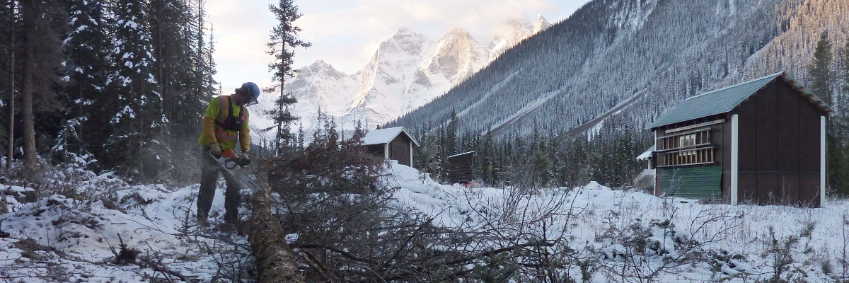
Any community that borders a vegetated or forested landscape can be impacted by wildfire. Parks Canada’s fire management efforts help lessen this risk. In addition to prescribed fire and managed wildfires, fire personnel use a variety of other wildfire risk reduction strategies. These include: Did you know: Parks Canada is an active member of the FireSmart™ program. The FireSmart™ program empowers the public and increases community resilience to wildfire across Canada. Learn more about how you can protect yourself and your community. Visit FireSmart Canada to learn what you can do to FireSmart™ your home and community. If you have a business or are a resident in Yoho National Park, visit the Stewardship and management page to learn about the specific processes within the park. Each of these strategies reduces the amount of fuel (trees) in the area. This helps protect the public, communities, and infrastructure by: Approved wildfire risk reduction and FireSmart™ projects Wildfire risk reduction and FireSmart™ projects are primarily completed in the fall, winter, and spring when the proper conditions exist. This work focuses on thinning out regrowth on the lower slopes above the community of Field where wildfire risk reduction work was previously completed in 2007. Re-treating this area is a multi-year project and works toward re-establishing sections of the Field Community Fire Guard through hand-thinning. Fire crews re-treated 4.3 ha in fall 2025 and work is expected to continue as early as fall 2026. Additional updates will be provided before this work starts again. FireSmart™ work around the Ice River Warden Cabin is dependent on time and resources. The Ice River Warden Cabin is located in the Ice River Valley in Yoho National Park. Treatment areas will be closed during work. This will not affect trails, roads, or facilities. These closure details will be posted on site. Please respect all closures and warning signs. During wildfire risk reduction work, trees, tree limbs, and brush are put into piles. Sometimes these piles of woody debris are too wet, or venting conditions are too poor to burn. These piles are left, and crews return to burn when the piles are dry, and conditions are good. The piles of woody debris are in different locations around Yoho National Park. Burning at each location will only take place when it is safe to do so and when appropriate venting conditions exist. Visitors and residents can expect to see smoke. Treatment areas will be closed when crews are burning piles of woody debris. The work will not affect trails, roads, or facilities. Closure details will be posted on site. Please respect all closures and warning signs. Wildfire risk reduction and FireSmart™ projects in development Additional information will be shared as project details become available. The Boulder Creek Fire Guard project will use mechanical tree removal to clear approximately 21.1 hectares near Boulder Creek to help reduce wildfire risk. This includes removing trees from a 13.8 hectare area that was previously thinned by fire crews in 2011. The project aims to make the landscape more resilient to wildfire and to reduce risk to the community of Field and nearby areas within Yoho National Park. It will also be used as a containment guard for the future Ottertail prescribed fire, which is still under development. Project planning is ongoing, with mechanical tree removal anticipated to begin as early as fall 2026. Additional details will be shared in fall 2026.
The Field Community Fire Guard project involves mechanical tree removal across an 18.1 hectare area surrounding the community of Field. This work will help re establish a fire guard that was originally constructed in 2007. Re establishing the fire guard will improve landscape resilience to wildfire and help reduce wildfire risk to the community of Field. Project planning is currently underway, with mechanical tree removal expected to begin as early as fall 2026. More information will be shared in fall 2026. Learn more about Parks Canada's efforts in reducing the risk of wildfires across the country. Stay informed about fire management activities by joining the Fire information email list. When you subscribe, you’ll receive updates on:Wildfire risk reduction and FireSmart™ projects

Tree thinning near the community of Field (seasonal, ongoing)
FireSmart™ Ice River Warden Cabin (tentative)
Pile Burning (seasonal, ongoing)
Boulder Creek Fire Guard
Field Community Fire Guard – Mechanical tree removal
Email notification lists
- Date modified :