

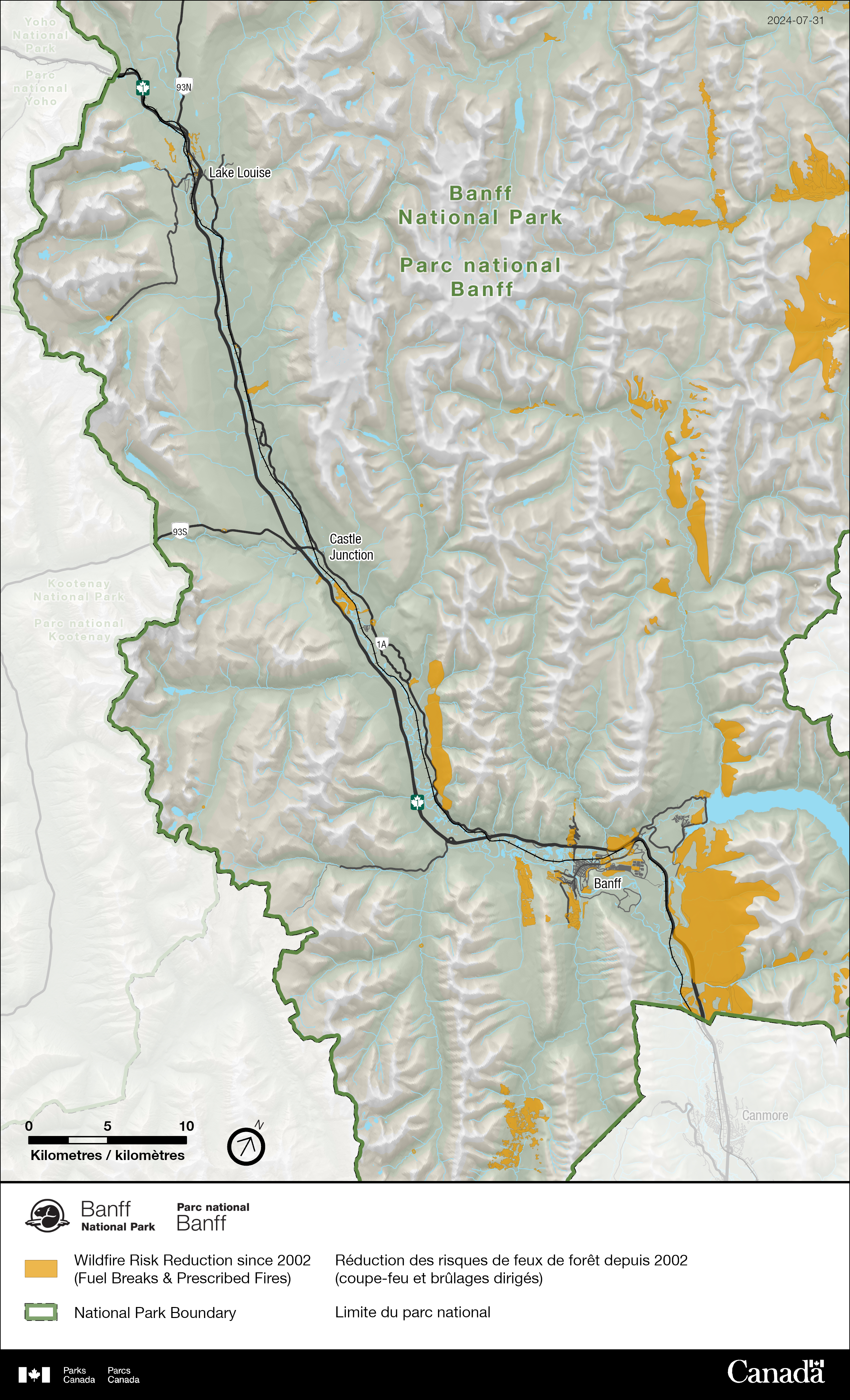
Fire protection and restoration projects
Banff National Park
Since 2002, Parks Canada’s fire management team in Banff National Park has
treated over
14,935.39
hectares
through
73
projects
and, an additional
1,762
hectares are in planning
As our climate changes, fire seasons are predicted to become longer. Wildfires may become larger and burn more severely. This is partly due to expected drought that will create dry, flammable conditions across much of the country. Parks Canada is creating a more diverse and resilient landscape in Banff National Park through its fire management program. This program includes both restoration and wildfire risk reduction work. Resilient landscapes include a healthy combination of forests and grasslands that can persist in the face of climate change and increased wildfire.
Reintroducing fire?
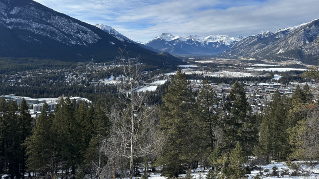
In its most natural state, the landscape of Banff National Park would have looked much different than it does today.
The landscape would have been a mosaic of alpine meadows, closed forest in the subalpine, and a mixture of grasslands and open forests in the valley bottoms. These ecosystems were resilient to fire, forest insects and disease, the budding effects of climate change, and were important for wildlife.
Parks Canada is committed to supporting Indigenous Peoples’ reconnection to the lands and restoring cultural burning practices. Parks Canada is working to develop long-term relationships with Nations across Canada. Part of this relationship building includes following Nations’ guidance on how and how much communities want to be involved in fire management and supporting Indigenous-led cultural burning practices.
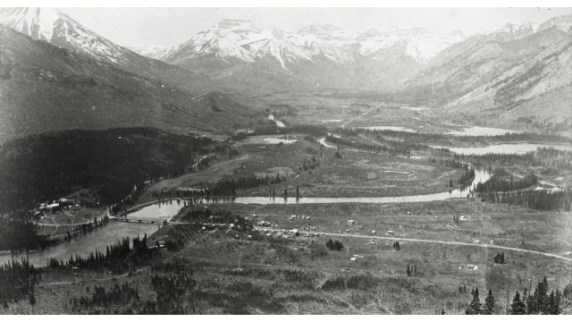
Before European settlement, fires burned in areas where Banff National Park now exists. Lightning ignited wildfires. Fires were also lit by Indigenous Peoples. This was to maintain travel routes and support culturally important plant and wildlife species. With the creation of the national park in 1885, Indigenous cultural fire practices were banned. The federal government forcibly removed Indigenous Peoples from the park. Fire was excluded for almost a century. This practice has resulted in a build-up of dense vegetation, where similar- aged forests blanket the valley bottoms. The combination of a warming climate and the build-up of vegetation increases the potential for larger and more intense wildfires.
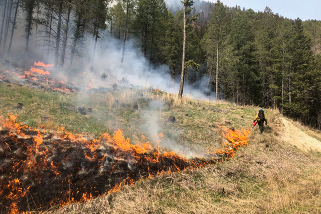
To address this, Parks Canada began reintroducing fire to the landscape in 1983. This was done using prescribed fire and moving away from suppressing all wildfires. Today, we continue to manage wildfires and use prescribed fires to restore healthy forests and grasslands and enhance wildlife habitat. Managed wildfires and prescribed fires also reduce the risk of wildfire to communities.
The 2020 Fire Management Plan for Banff, Yoho, and Kootenay National Parks guides restoration and wildfire risk reduction projects. Below you will find information on the projects in Banff National Park.
Approved prescribed fires
Parks Canada lights prescribed fires only when predetermined weather and site conditions are met. Because of this, it may take several years before the right conditions happen, and the fire can be safely lit. Updates will be available here when a prescribed fire is underway.
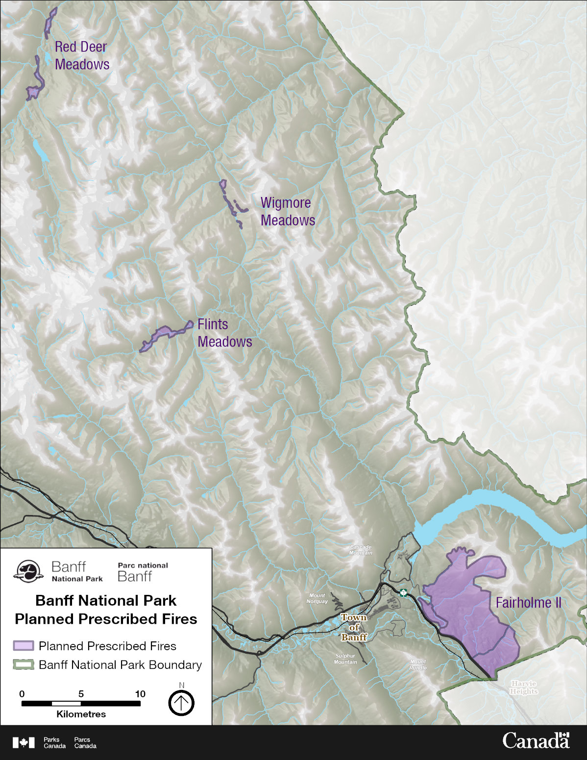
Wigmore Meadows
Date: Spring/Fall
Location: In the Wigmore Valley, south of Windy Warden Cabin.
Additional details: Prescribed fire will restore native meadow habitat in Banff National Park. These meadows provide critical, year-round habitat for mountain sheep, goats, grizzly bears, wolves, elk, and bison.
UPDATE:On May 10th and 11th, 2025, Banff National Park entered a prescription window for Wigmore Meadows. Parks Canada treated 65.5 ha of the prescribed unit at that time.
Flint’s Park Meadows
Date: Spring/Fall
Size: 262 hectares
Location: In the Cascade Valley, west of Flint’s Park Cabin
Additional details: Prescribed fire will restore native meadow habitat in Banff National Park. These meadows provide critical, year-round habitat for mountain sheep, goats, grizzly bears, wolves, elk and bison.
Upper Red Deer Meadows
Date: Spring/Fall
Size: 200 hectares
Location: Upper Red Deer Meadows - Red Deer Valley between Scotch Camp and Sandhills Cabins.
Additional details: Prescribed fire will restore native meadow habitat in Banff National Park. These meadows provide critical year-round habitat for grizzly bears, wolves, elk, deer, and bison.
Fairholme II
Date: Spring/Fall
Size: 4,469 hectares
Location: In the front ranges of Banff National Park, between the Banff East Gate and Johnson Lake area, and the Trans-Canada Highway.
Additional details: Previously burned in 2003, the Fairholme II prescribed fire will improve habitat for wildlife like grizzly bears and will reduce the risk of wildfire to local communities, including the Hamlet of Harvie Heights and the Town of Canmore. A re-burn of the site is required to reduce lodgepole pine regrowth, restore montane grasslands, and open forests that historically occupied this area.
To help ensure smoke impacts are minimized and to protect local communities during fire operations, a smaller-scale prescribed fire may be conducted within the main prescribed fire unit, with the full unit to occur later. Both operations are dependent on favourable weather conditions.
UPDATE: Fairholme II Unit plan is currently under review. In an effort to prepare for the project, Parks Canada may complete some additional site preparation activities this year should conditions permit.
Prescribed fire plans in development
Prescribed fire planning is a complex process. Each prescribed fire plan can take years to complete. Once the prescribed fire plan is approved, the fire can be carried out in the same year if the weather and on site conditions are right.
Pipestone Meadows
Time of year: Spring/fall
Size: 692 hectares
Location: Backcountry within the Pipestone River Valley and the Cyclone/Red Deer Lakes area. Located between 11 km and 25 km north of Lake Louise.
Additional details: The Pipestone Meadows prescribed fire consists of five meadows. These meadows are included in one of three prescribed fire units:
Cyclone Meadows Unit – includes the 119-ha Cyclone Meadow the 23-ha Little Pipestone Meadow
Point Camp Meadows – Point Camp Meadow unit is 167 ha
Singing Meadows – includes the 138-ha Upper Singing meadow and 95-ha Lower Singing Meadow
Prescribed fire operations may target one or more meadows at a time. Each application of prescribed fire contributes to the project’s goals by:
- reduce the spread of conifer trees and keep a natural mix of plants in open meadow areas
- support the regrowth of native grasses and shrubs
- help restore the natural fire cycle, which normally includes low to moderate‑severity wildfires
- lower the risk of severe wildfires and help the landscape become more resilient to future fires
Clearwater Prescribed Fire
Date: Spring/Fall
Size: 3913 hectares
Location: In the Clearwater and Roaring Creek drainages approximately 80km north of the Town of Banff. 654 ha are located within the R11 Forest Management Unit of Alberta Forestry jurisdiction.
Additional details: Prescribed fire will restore the historic fire regime and increase habitat heterogeneity favourable for ungulates, grizzly bears and wolves.
Palliser Prescribed Fire
Date: Spring/Fall
Size: 4120 hectares
Location: In the Palliser Valley approximately 35km south of the Town of Banff.
Additional details: Prescribe fire will restore the historic fire regime and increase open vegetation communities improving habitat and forest health.
Cascade River Prescribed Fire
Date: Spring/Fall
Size: 4135 hectares
Location: In the Cascade Valley north of Lake Minnewanka on slopes East of the Cascade Fire Road.
Additional details: Prescribed fire will reduce fuel build-up and improve quality and quantity of forage habitat for large mammals such as grizzly bears and ungulates.
Wildfire risk reduction projects
Did you know: Parks Canada is an active member of the FireSmart™ program?
The FireSmart™ program empowers the public and increases community resilience to wildfire across Canada. FireSmart™ Canada works closely with communities within the national park including the Town of Banff and the Village of Lake Louise. They also work with neighboring communities outside Banff National Park.

Parks Canada is committed to protecting communities in Banff National Park from wildfire. In addition to prescribed fire and managed wildfires, fire personnel use a variety of other wildfire risk reduction strategies. These include:
- FireSmart™
- Forest thinning
- Mechanical tree removal
Each of these strategies reduces the amount of fuel (trees) in the area. This helps protect the public, communities, and infrastructure by:
- Limiting fire intensity.
- Reducing the potential for spot fires from windblown embers.
- Improving the effectiveness of fire suppression techniques.
All projects go through rigorous planning and environmental impact assessment processes. These processes identify potential impacts and mitigations to minimize these impacts.
Parks Canada operates through sustainable practices. The trees removed during these projects are processed, and one or more of the following occurs:
- Indigenous Peoples may harvest trees for ceremonial use, and/or for teepee poles.
- The lumber may be brought to market at sawmills and pulp mills for commercial use.
- Woody debris may be collected in piles and burnt on location.
- Woody debris may be collected and converted into biochar for use as a sustainable energy source.
- Woody debris may be used locally for firewood or at facilities that need wood fibre (eg. the Lake Louise wastewater treatment plant).
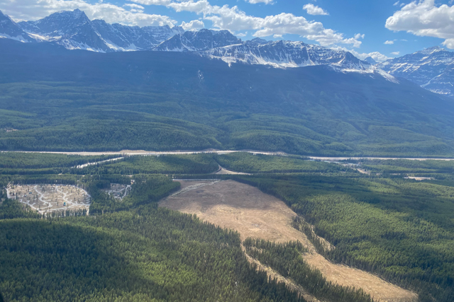
Below is an overview of approved wildfire risk reduction projects in Banff National Park.
These projects are primarily completed in the fall, winter, and spring when the proper conditions exist.
Banff area
Spray Middle Springs Wildfire Risk Reduction Project
ATTENTION: Active area closures will be in place for the Spray Middle Springs Wildfire Risk Reduction Project.
For more details and impacts to trails in the area, please visit the Important Bulletins.
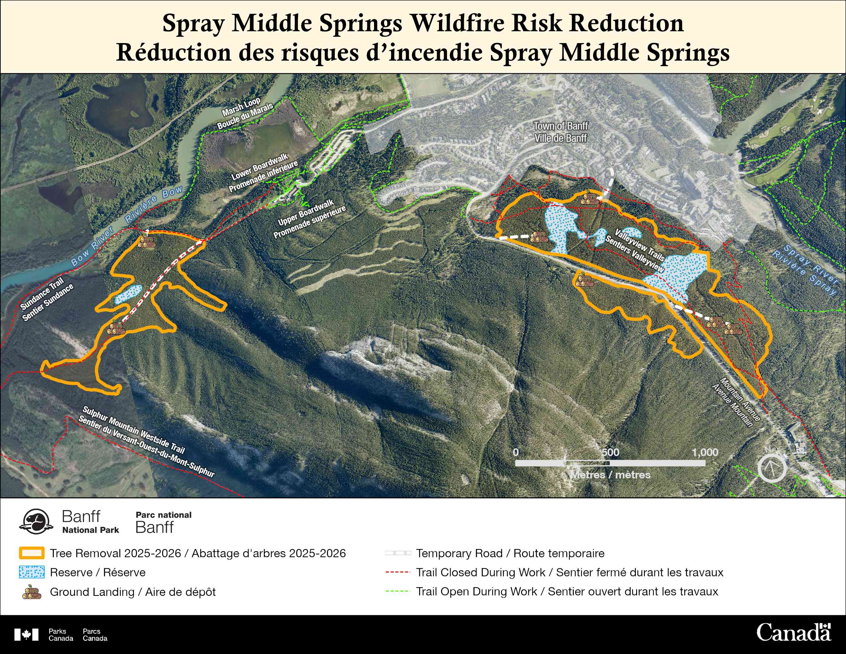
Size: 125 ha
Project description
As part of the Agency’s commitment to reducing the risk of wildfires within Banff National Park, Parks Canada is proceeding with planned fire management actions in the Spray Valley- Middle Springs area of the national park. The Spray Middle Springs Wildfire Risk Reduction Project will treat a 125-hectare area with mechanical tree removal and thinning. The project will reduce the amount of fuel for wildfires on the base of Sulphur Mountain, which would aid in wildfire suppression and further protect the Town of Banff. Additional blocks are planned for the following winter.
This project will take place over two winter seasons, begin in early December 2025, with planned completion in the Spring of 2027. This project is in close in proximity to residential neighbourhoods within the town of Banff, and there will be impacts from the operations to residents and visitors in the area. Parks Canada recognizes these impacts and has taken many precautions to minimize disturbance as possible to the public.
Project impacts
- Area closures: The Spray– Middle Spring Wildfire Risk Reduction Project work will only be occurring on Parks Canada lands, and contractors will take care to not enter residential or commercial property. For the safety of the public and contractors in the project area, area closures will be put in place for the duration of the Spray Middle Springs Wildfire Risk Reduction Project. This includes all trails in the closed areas. Residents and visitors must not attempt to access the closed area for safety reasons. Violators may be charged under the Canada National Parks Act: maximum penalty $25 000. For a complete list of up-to-date closures in Banff National Park please visit: www.parks.canada.ca/pn-np/ab/banff/bulletins.
- Noise impacts: Wildfire Risk Reduction work can be noisy. The public can expect noise disruptions from mechanical equipment such as feller bunchers, processors, skidders, log trucks, excavators, chain saws and trees falling in the area. The majority of mechanical work will occur during daylight hours. However, logging trucks, including hauling and debris management may still be active in the early morning, and evening hours.
- Traffic impacts: During operations, the public can expect to see and hear logging equipment harvesting and processing mature trees and trucks hauling logs down Mountain Avenue and Rundle Ave via Spray Avenue towards the Trans-Canada Highway. Mountain Avenue will remain open for the duration of the project, but motorists may encounter minor traffic disruptions over the course of the project. Traffic control will be on-site as needed. Please comply with their direction and respect traffic flaggers.
- Smoke impacts: Woody debris will be piled and burned on-site for this project, and for other wildfire risk reduction projects occurring through the Bow Valley. Smoke will be visible throughout the national park, and valley. Every effort will be made to limit smoke during pile burning - however, unpredicted changes in weather can increase and/or redirect smoke. Burning will only be conducted under conditions that limit the spread of the smoke in the area
Additional information:
- This work is part of the approved Fire Management Plan for Banff, Yoho & Kootenay national parks (2020).
- The area will look different than what we’re used to and there will be landscape level changes. The land may look bare initially, but grasses, flowers, and shrubs will quickly return to the area. This return to a more natural open landscape builds a more wildfire resilient landscape for Banff National Park.
Tunnel-Toe Wildfire Risk Reduction Project
ATTENTION: Active area closure in place for Block B of the Tunnel Toe Wildfire Risk Reduction Project.
For more details regarding closure impacts to trails in the area, please visit the Important Bulletins.
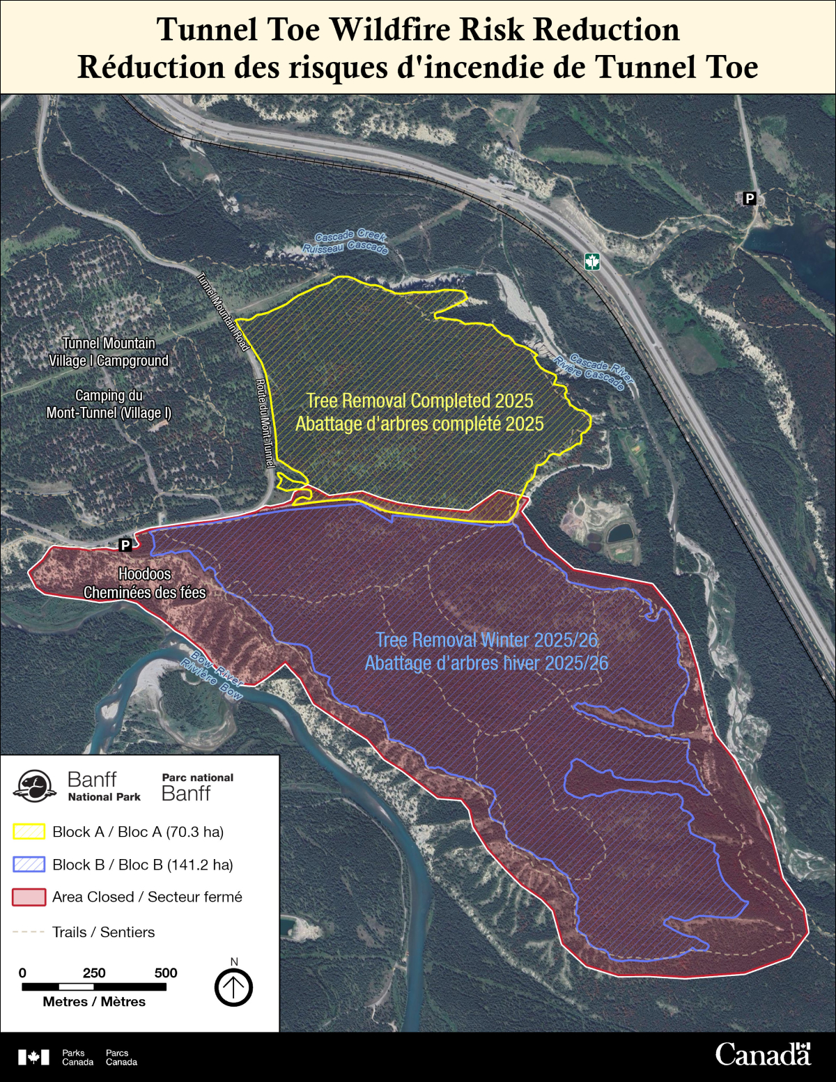
Size: 211.5 ha
Project description
This past winter (2025), Parks Canada made significant progress on the Tunnel Toe Wildfire Risk Reduction Project within Banff National Park. Parks Canada is pleased to report that Block A (70.3 ha) and 10 ha of Block B of the project were completed ahead of schedule. The project will resume this Fall 2025, into Winter 2026, with Parks Canada planning to the complete the remaining 131.2 ha of Block B.
The 211.5 ha project includes mechanical tree removal in the Tunnel Mountain area to create a break in fuel, which will help reduce the wildfire risk to nearby communities such as Banff, Harvie Heights, and Canmore. In addition, this project aims to remove mountain pine beetle-affected trees, reduce tree cover, fuel loading, and create a more open meadow and forest habitat.
The project is expected to be completed in spring 2026.
Closure status: Active
For public safety, an area closure will be in place for the duration of the active work happening on the Tunnel Toe Wildfire Risk Reduction Project. This includes all hiking, and mountain biking trails in the area. Residents and visitors must not attempt to access the closed area for safety reasons. Violators may be charged under the Canada National Parks Act: maximum penalty $25,000. For a complete list of up-to-date closures in Banff National Park, please visit: www.parks.canada.ca/pn-np/ab/banff/bulletins.
Smoke:
With the extension of winter conditions, woody debris will be piled and burned on-site for this project and others happening within the national park. Smoke will be visible throughout the park. Every effort will be made to limit smoke during pile burning. However, unpredicted changes in weather can increase and/or redirect smoke. Pile burning will only begin as conditions allow.
Traffic:
During operations, the public can expect to see and hear logging equipment harvesting and processing mature trees and semi-trucks hauling timber along Tunnel Mountain Drive towards the Trans-Canada Highway. Tunnel Mountain Road will remain open for the duration of the project, but motorists may encounter minor traffic disruptions as falling occurs near the roadways. Traffic control will be on-site as needed. Please comply with their direction and respect traffic flaggers.
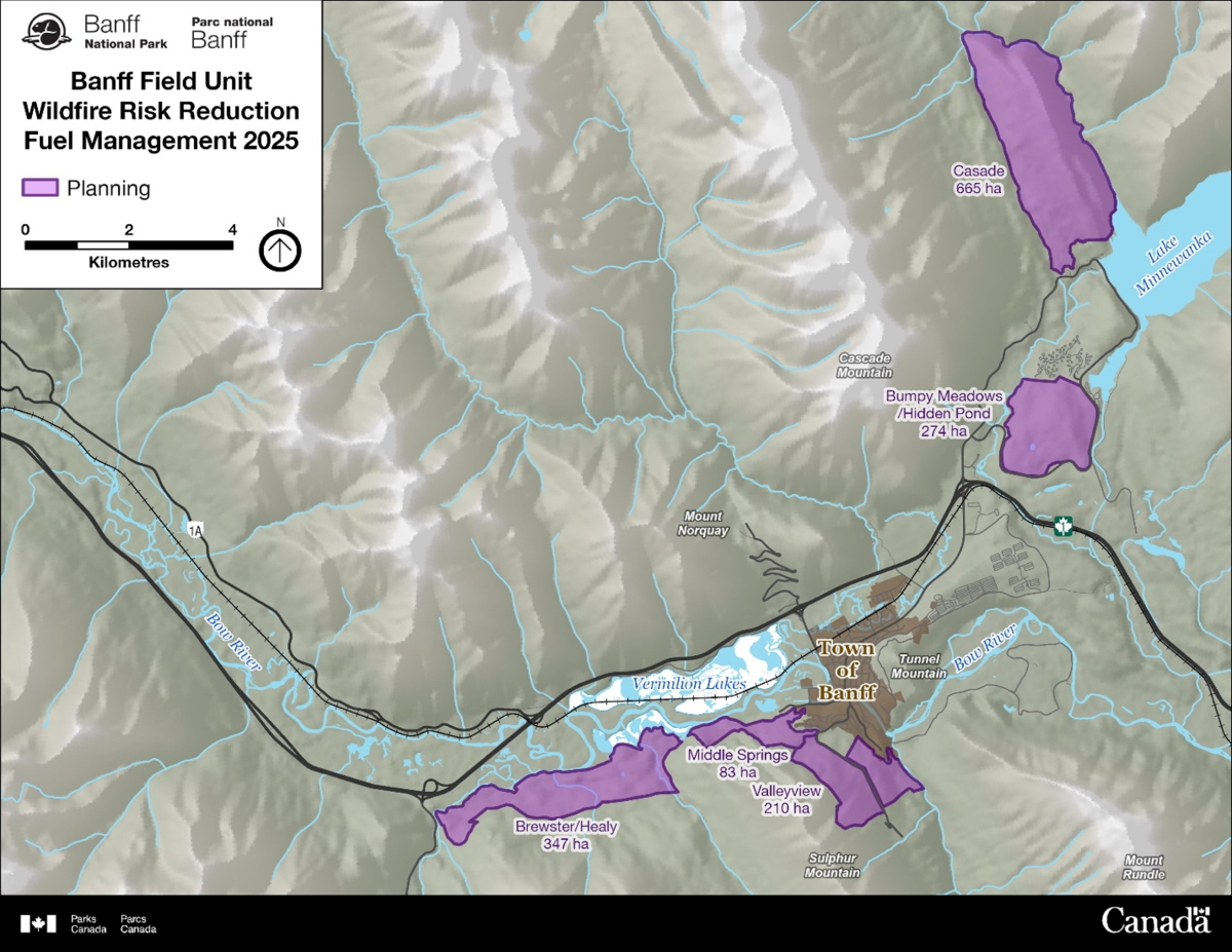
Wildfire Risk Reduction Fuel Management in Banff 2025/2026
In addition to the wildfire risk reduction work around Tunnel Mountain (211 ha), Parks Canada is working on planning for an additional 1,762 ha (17.62 km²) of wildfire risk reduction activities within the 15 km radius of the town of Banff to help mitigate wildfire risk to the community.
Below is a brief overview of the units identified for future work:
Spray Valley Unit
Size: 125 ha
Project description
Parks Canada is planning to complete 125 hectares of tree removal and thinning in the Spray Valley - Middle Springs area of the national park.
Benefit: The project will reduce the amount of fuel for wildfires on the base of Sulphur Mountain, which would aid in wildfire suppression further protecting the Town of Banff. The project is expected to be completed by Winter 2027.
Brewster/Healy Creek Unit
Size: 347 ha (3.4km²)
Project description
Why: The Brewster/ Healy Creek area is identified as a candidate unit as it predominantly consists of a fully stocked lodgepole pine forest that acts as a continuous fuel type upwind of the Town of Banff.
Benefit: The objective behind this unit would be to thin the fuels to reduce fire intensity and rate of spread in the event of a wildfire upwind to the west of the Town of Banff. By reducing fire intensity, it will increase the probability of a successful initial attack and increase the chances of containing fire within—or prior to—the West Sulphur fuel break.
Middle Springs Unit
Size: 83 ha (0.86 km²)
Project description
Why: The Middle Springs area has received numerous iterations of fuel reduction to protect the west side of the Town of Banff. Much of the work was conducted in the mid-2000s and involved mechanical thinning of rows west of the neighbourhood. The purpose of this unit would be to assess the previous fuel treatments through the lens of new research and updated understanding of fuel and fire behaviour with respect to climate change and fuel modification.
Benefit: This treatment would allow Parks Canada to assess opportunities and identify new areas within the unit and nearby to apply new research learnings, such as thinning treatments, to enhance the current fuel break.
Valley View Unit
Size: 210 ha (2.10 km²)
Project description
Why: Like the Middle Springs Unit, most of this area was treated mechanically in the early 2000s to protect the town from an approaching wildfire in the Spray Valley.
Benefit: The purpose of this unit is also to seek opportunities to expand off current thinning treatments by identifying new areas to thin in order to enhance the overall fuel break.
Bumpy Meadows / Hidden Pond Unit
Size: 274 ha (2.74 km²)
Project description
Why: This unit is located northeast of the Town of Banff and captures the bulk of the area between the Two Jack Main campground and Minnewanka Loop Road. The purpose of this unit would be to expand off thinning work that was completed in the late 1990s and prescribed fire in 2003 in order to help protect the communities in the Bow Valley from a fire approaching from the Cascade Valley.
Benefit: By treating this unit, Parks Canada and wildfire responders can also easily access water control features, including the Minnewanka Loop Road, Cascade Pit, Two Jack Canal, Lake Minnewanka, Upper/Lower Bankhead, and Two O’Clock Creek.
Cascade Unit
Size: 665 ha (6.65 km²)
Project description
Why: The Cascade unit is located northwest of the Lake Minnewanka Day Use Area (Figure 6). This unit has the purpose of creating a fuel break in the event of a wildfire approaching from the Cascade Valley. The Cascade Valley has very continuous pine and spruce fuel types with very few landscape features to slow down the progress of fire from further up the valley.
Benefit: This unit would also pose a major benefit by creating a fuel break to facilitate future prescribed fire in the Cascade Valley, which would significantly reduce the overall risk of wildfire to the communities in the Bow Valley. This unit has the decommissioned Cascade Fire Road, which remains as a very wide, hardened trail, which may simplify the access to this unit significantly.
Lake Louise area
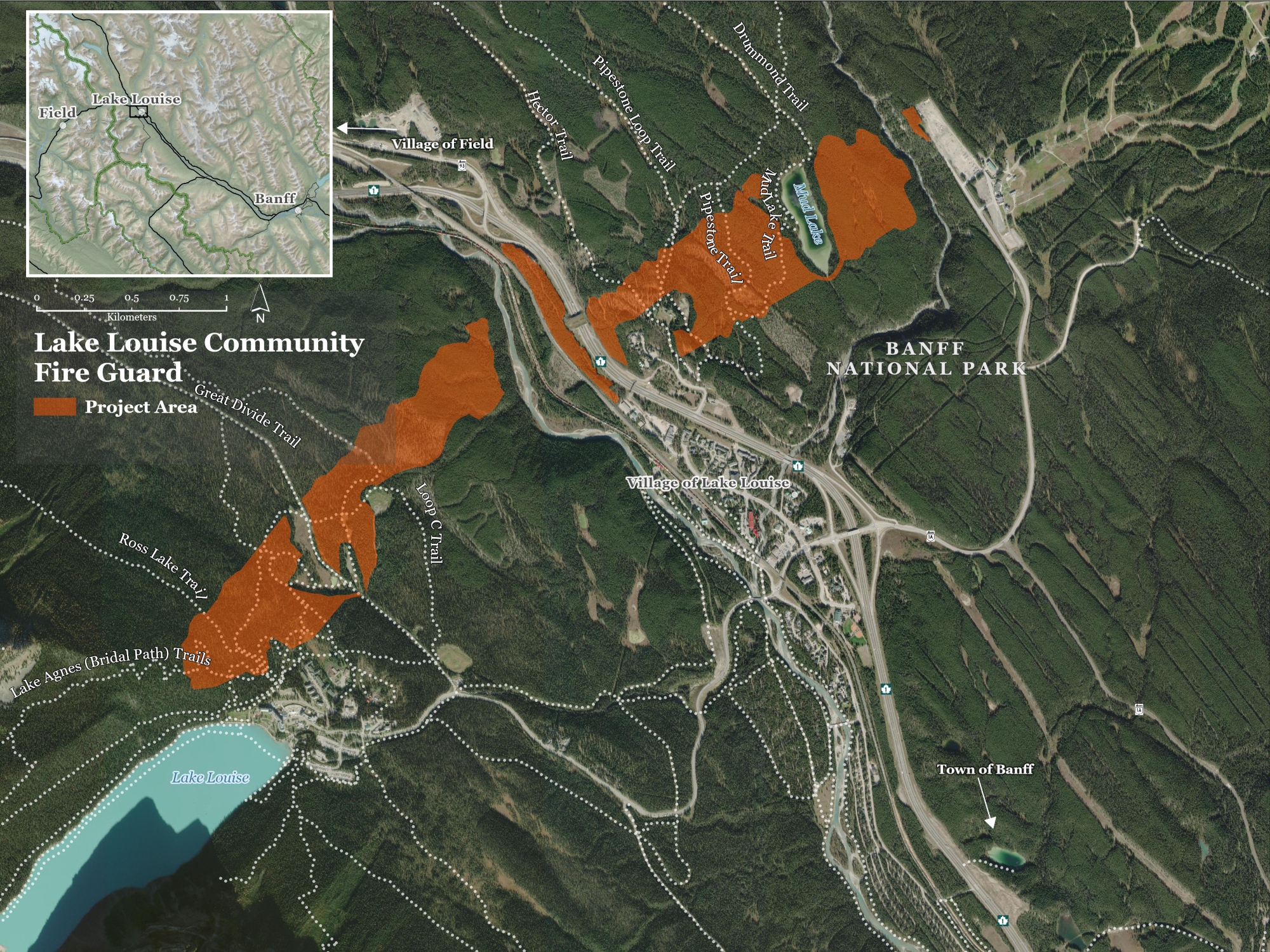
Lake Louise Community Fire Guard (completed April 2026)
Size: 165.4 ha
Project description
Map of full project area
*Unit boundaries are subject to change
The Lake Louise Community Fire Guard project is a continuation of over a decade of wildfire mitigation work around the community of Lake Louise. The Lake Louise Community Fire Guard creates a landscape-level forest fuel break, which will:
- reduce the risk of wildfire to the community of Lake Louise and surrounding areas
- improve safety for park visitors and residents
- improve wildlife corridors and foraging habitat away from roads or railways
The fire guard stretches from the south slope of Mount St. Piran behind the Fairmont Chateau Lake Louise to the parking lot and ski runs of Lake Louise Ski Hill on Whitehorn Mountain.
Update
Mechanical tree removal work and pile burning on Phase 2 of the Lake Louise Community Fire Guard has been completed. Approximately 72 ha were treated between November 2025 and March 2026. This completes mechanical tree removal work on the Lake Louise Community Fire Guard project. Once the snow melts specialists will begin to restore disturbed soil and monitor vegetation.
Some additional hand-thinning work will occur as early as fall 2026. This work will consist of Parks Canada fire crew or contractors removing trees using chainsaws in select areas of the fire guard. Details will be provided before work starts.
Area closures: Effective April 29, 2026, the area closure associated with work on the Lake Louise Community Fire Guard has been lifted.
The Pipestone trail area is open for recreational use. However, cross-country ski tracksetting will not occur for the remainder of the 2025/2026 season. Regular tracksetting operations are expected to resume for the 2026/2027 season.
Due to woody debris near the surface of the snow, it is not recommended to access the winter activity trails for the remainder of the season. Parks Canada will assess the trails and clear the woody debris off once the snow melts.
For an up-to-date list of area closures in Banff National Park, visit the Important Bulletins page.
Background
Initial work such as surveys, impact assessments and stakeholder engagement began in 2018. The physical work on the Lake Louise Community Fire Guard started in November 2024. A contractor worked on completing mechanical tree removal in Phase 1 on the west side of the Trans-Canada Highway near the Great Divide Trail between November 2024 and March 2025. Trees were removed from 70.1 ha. . Throughout the summer of 2025, specialists restored disturbed soil and monitored vegetation in this area.
Lake Louise Community Fire Guard – Hand thinning
Project description
As early as September 25, 2025, trees will be removed by hand falling in some areas of the Lake Louise Community Guard project area in Banff National Park. Hand falling will occur in select areas where mechanical tree removal work is not occurring.
Area closures: The community of Lake Louise and seasonal facilities will remain open. Treatment areas will be closed during work. These closure details will be posted on site. Please respect all closures and warning signs.
Protection Mountain Fire Guard – Hand thinning
Project description
Hand thinning work on the Protection Mountain Fire Guard is dependent on time and resources this fall.
The Protection Mountain Fire Guard is located along Highway 1A, adjacent to the Protection Mountain Campground. Work will take place near the back of the Protection Mountain Fire Guard to thin trees and brush in areas that were too sensitive for low-impact machinery during the creation of the fire guard in 2022-2023. Reducing this vegetation will increase the effectiveness of the guard.
Area closures: Treatment areas will be closed during work. This will not affect trails, roads, or facilities. These closure details will be posted on site. Please respect all closures and warning signs.
*Unit boundaries are subject to change
Quick facts
- Fire reduces the buildup of dense trees, dead vegetation, and down wood. The open space and nutrient-rich ground help create better growing conditions for plants like buffaloberry. Buffaloberries are a critical food source for grizzly bears.
- Prescribed fire helps to maintain and restore native meadows and grasslands. It creates better growing conditions for drought- and fire-tolerant species like Douglas fir and aspen.
- A mosaic of habitat types can limit the size of a fire. Wildfires are difficult to suppress in dense pine stands. However, patches of open meadows and grasslands decrease a fire’s intensity. Previously burned areas also reduce a fire’s intensity and growth. This is because these areas have less fuel available to burn on the forest floor. Open meadows, grasslands and previously burned areas present places where fires can be extinguished more easily.
- In 1983 Parks Canada conducted its first prescribed fire in Banff National Park near Two Jack Canal (6 ha). This project solidified Parks Canada’s recognition that fire plays an important role in the ecosystem.
Frequently asked questions
What is the difference between fuel breaks, FireSmart™, and prescribed fire?
Fire guards, FireSmart™ and prescribed fires are all aspects of Parks Canada’s fire management program. However, they are quite different.
A fire guard is a large, strategically constructed feature on the landscape where fuels, such as trees, brush or leaves have been removed, often by mechanical means, or prescribed fire when safe to do so. This large gap in forest canopy fuels can help slow a wildfire and provide safe and strategic locations for fire fighters to respond. Proactively built fire guards increase protection and minimize impact to the environment.
FireSmart™ Canada is a community wildfire protection program. Examples of FireSmart™ work include removing shrubs, trees, deadfall or woodpiles within the first 10 meters of a building (zone 1). FireSmart™ can also include thinning and pruning of trees in other zones.
Prescribed fire is setting a planned fire under specific, pre-determined conditions to achieve certain goals. At Parks Canada, our goals include reducing the risk of wildfire, restoring and maintaining fire-adapted ecosystems and protecting cultural heritage. Prescribed fires are planned and managed by trained wildland fire management specialists.
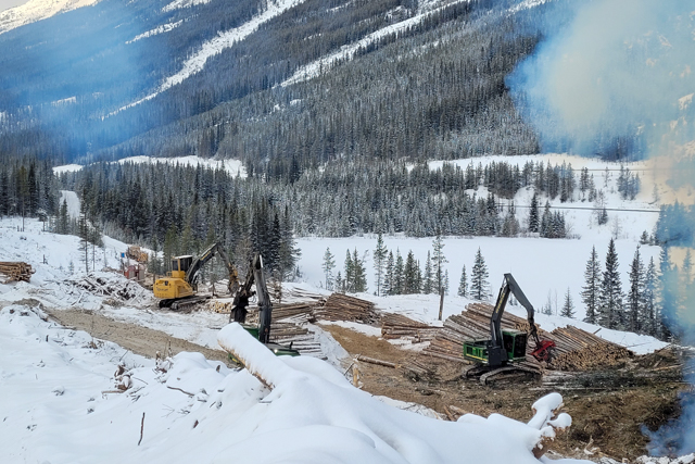
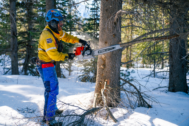
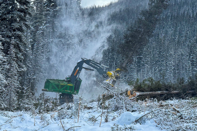
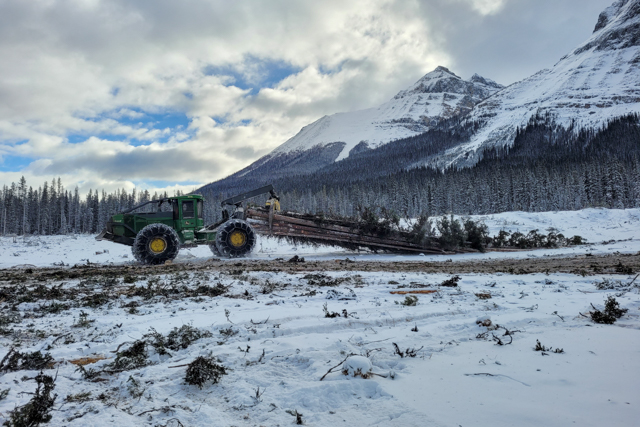
What is mechanical tree removal?
Mechanical tree removal is the cutting, processing and removal of trees using low-impact machinery in a national park. It is completed for fire management and ecological benefits. Mechanical tree removal is not-for-profit.
Typical machinery used for timber removal includes feller bunchers, skidders, single-grip processors, hoes, spider-hoes, and forwarders. Semi-trucks are used to haul cut logs.
Mechanical tree removal projects take environmental impacts into consideration and require all machinery to be low impact.
Are prescribed fires safe?
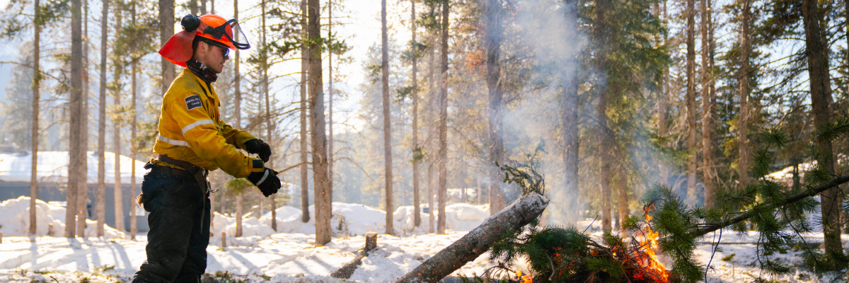
Safety is always Parks Canada’s top priority when planning prescribed fire.
At Parks Canada-administered places, prescribed fires are planned and managed by well-trained, professional wildland fire management specialists. Fire specialists carry out extensive planning and preparation before a prescribed fire is lit. For example, they:
- Evaluate the landscape and assess weather conditions and windspeed.
- Determine the number of people and equipment required to manage a prescribed fire.
- Evaluate and assess risks and scenarios.
The predetermined conditions are written into a prescribed fire plan. The prescribed fire can only occur if the conditions in the prescribed fire plan are met.
During a prescribed fire, surveillance plans are in place along with management strategies if more control support is required. The team also has firefighting equipment in place to contain the fire within pre-set boundaries. Helicopters may be used to monitor the prescribed fire’s progress. Additional crews and equipment are on standby to assist with control if required.
Why light prescribed fires?
Fire is a natural part of many ecosystems. It plays an important role in the maintenance of habitat for many plants, animals, and insects. It also reduces the buildup of dense forests and old wood. In some cases, wildfire is safe to manage and let burn. In other cases, it is unsafe to let a wildfire burn. Prescribed fires offer an alternative method to safely maintain fire-adapted landscapes.
How is smoke managed during prescribed fires?
Parks Canada makes every effort to limit smoke. Prescribed fire operations are only conducted under specific conditions. This helps to ensure the least impact possible for communities and visitors. Ignition will only occur on days with good atmospheric venting conditions to disperse smoke. Once the operation is complete, small amounts of smoke may be visible until the fire is fully extinguished.
What can I do to reduce wildfire risk?
There are many things you can do both at home and visiting Banff National Park to reduce the risk of wildfires.
Visit firesmartcanada.ca to learn what you can do to FireSmart™ your home and community. If you have a business or are a resident in Banff National Park, find out more about the specific processes required to complete tree removal within the park on the Fire risk reduction around your home or business page.
While visiting Banff National Park, stay informed on the current fire danger status and regulations. While we cannot avoid naturally occurring wildfires (e.g., lightning strikes), we can avoid human-caused fires. Please do your part to keep our communities and first responders safe by not lighting illegal campfires. If you see any wildfires, illegal campfires, or suspicious smoke, please report it to Banff Emergency Dispatch 403-762-4506.
Why are fuel breaks important?
The effects of climate change, in combination with historical fire suppression practices, are increasing the chance and severity of wildfires. Reducing forest fuels helps keep a potential wildfire on the ground rather than spreading from treetop to treetop. When fire is on the ground, it:
- limits fire intensity.
- slows the rate of spread.
- reduces windblown embers.
- makes it easier for responders to control.
Pre-established fuel breaks help contain wildfires quicker than when a fire guard is not in place. This reduces the risk to:
- communities
- visitors and residents
- infrastructure
- natural and cultural resources
Having a fuel break in place can reduce the length of time a wildfire burns, which can reduce the impact on air quality.
By planning carefully, we can design fuel breaks to improve ecological integrity. Once completed, the open areas allow sunlight to reach the forest floor. Here, sun-loving plants can flourish. These plants provide important food sources and foraging opportunities for wildlife such as grizzly bears and elk.
What does the work look like to build a fuel break using mechanical tree removal?
A lot of work goes into a fire guard. They often take years of planning before the first tree is cut.
Once the project is approved, external contractors are hired to complete the work. Work often starts in the fall. This includes building temporary access roads. Mechanical tree removal work is completed during the winter months to reduce impacts to soils and vegetation. Once the ground is frozen and/or there is snowpack, heavy equipment cut and remove trees from the area to create the opening. Small vegetation and woody debris get piled and burned on site. Sometimes it is chipped and hauled off-site. Tree removal wraps up by the end of March each year until the project is completed. During the summer, in areas where tree felling has been completed, Parks Canada works on restoration.
How do fuel breaks created by heavy equipment change the landscape?
To achieve a break in forest canopy fuel, there is a noticeable difference relative to what an area looked like before. Once complete, a fuel break has fewer trees across the project area. The landscape dictates the areas that trees can be removed from within the project boundary. Where possible, natural features are used to minimize the number of trees that need to be removed. Irregular borders help make the fire guard look more natural.
Although changes are evident in the first couple of years after tree removal, it doesn’t take long for ground-covering vegetation to grow back. The freshly created openings allow more sunlight to reach the ground. This permits new grass and shrubs to establish over time.
How do you protect the environment while creating fuel breaks?
Parks Canada completes impact assessment processes. These processes identify potential impacts and mitigations to minimize these impacts. Project managers work closely with specialists to make sure projects carry ecological benefits and protect cultural resources.
Vegetation: Before starting work, specialists survey the project area. They flag trees that will be kept, such as mature Douglas-fir, deciduous, and endangered trees.
After the fire guard is complete, Parks Canada restores disturbed areas with native vegetation.
Soils: Equipment and vehicle access is restricted to well-drained or frozen soils. This minimizes soil disturbance and potential for soil erosion.
Watersheds: A riparian buffer zone will be maintained around all lakes, streams, and wetlands.
Machinery only crosses streams at designated crossings. Appropriate protocols are put in place to prevent bank damage and soils or other debris from entering the watercourse.
Wildlife: Trees that provide important wildlife habitat for cavity-nesting birds and other species such as bats listed under the Species at Risk Act (SARA) are identified and protected. The primary breeding seasons for these species will be avoided by completing the work in the winter months.
Cultural Resources: A no-work zone is maintained around all identified Indigenous and cultural sites or resources. If a previously unknown cultural resource is found during the project, protocols are in place to protect it.
Email notification lists
Banff area
To be added to the smoke notification list or the community stakeholder list, please contact: banff.fireinfo-infofeu.banff@pc.gc.ca
Lake Louise area
To receive fire information updates for the Lake Louise, Castle Mountain, and Icefields Parkway areas in Banff National Park, please subscribe to our email list.
For general fire information inquiries, please contact: feullyk-llykfire@pc.gc.ca
- Date modified :