
125 of our favourite Waterton facts
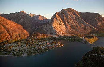
Waterton Lakes National Park
125 interesting, remarkable and delightful facts about Waterton Lakes National Park.
Overview
Places and names
People
Indigenous peoples
Designation
Landforms
Nature and wildlife
Natural processes
Overview
- In 1895, a 140 km2 area was protected by the federal government as a Forest Park Reserve. Its status, boundary and name have varied over the years, but it is now known as Waterton Lakes National Park.
- Waterton Lakes is Canada’s fourth national park and is the smallest in the Canadian Rockies.
- Waterton Lakes National Park sits in the extreme south-western corner of Alberta.
- The park attracts around 500,000 visitors each year. Nearly 50 per cent of visitors come in July and August.
- The park shares boundaries with British Columbia and Montana in the United States.
- Waterton Lakes National Park covers an area of 505 km2.
- The park is well known as 'where the mountains meet the prairies' - here the great plains abruptly interface with the mountains without foothills transition.
- The park has about 200 km of hiking trails, making its backcountry the most developed of the Canadian mountain parks.
- The park's elevation ranges from 1,280 m at the community of Waterton to 2,910 m at the summit of Mount Blakiston.
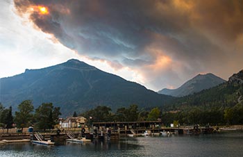
- In 2017, the Kenow Wildfire burned 38% of the park and 50% of its vegetation. Recovery efforts are still underway.
Places and names
- The park’s name derives from the Waterton Lakes. This chain of lakes, named by Lieutenant Blakiston (a member of the Palliser Expedition), honours a British naturalist, Squire Charles Waterton (1782-1865).
- Sheep Mountain was renamed Vimy Peak in 1917 in honour of the Canadian Army’s victory at the Battle of Vimy Ridge.
- Linnet Lake, just north of the Prince of Wales hotel, was mistakenly named for a finch that does not live in Canada when explorers mistook native birds in the area for the linnet.
- Mount Bertha is the only mountain in Waterton named after a woman, though her identity is uncertain. Some claimed her to be an early resident of the park, others a bootlegger and counterfeiter during the prohibition as well as several other theories.
- Chief Mountain border crossing is the highest above sea level customs office in Canada.
- Before the Bear's Hump trail to the popular viewpoint was built, it was known as the Pimple.
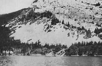
- Emerald Bay is named for its turquoise colour. It was formerly called Steamboat Bay, for the boat, 'Gertrude', which was purposely sunk there.
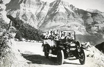
- The park's first hiking trail, the Lakeshore Trail, was built in 1911, 16 years after the establishment of the park.
- Construction began on the lower portion of the Akamina Parkway (from the townsite to the Crandell Lake trailhead) in 1921. The completed road to Cameron Lake opened in 1927.
- Carthew, Creek, Lakes and Mount were named for boundary surveyor, Lt. William Morden Carthew, who surveyed in the Waterton area and later died in the First World War.
- Alderson Mount, Lake and Creek were named to honour British Lieutenant General Edwin H.A. Alderson, the first commander of the Canadian Expeditionary Forces during the First World War. Alderson led the 1st Canadian Division into its first battles in France in 1915.
- The Prince of Wales Hotel was named after the then popular Edward, Prince of Wales, later recognized as King Edward VIII. No Prince of Wales has ever visited the hotel.
- The Prince of Wales Hotel was built by the Great Northern Railway and was constructed entirely of locally (Montana) milled lumber. It opened its doors on July 25, 1927. Today it is one of Waterton's most recognized landmarks.
- During the construction of the Prince of Wales hotel in December 1926, hurricane-force winds (estimated at 145 km/hr) blew each of the hotel's wings out of square – by about 7.5 cm. Three months later winds reached speeds of over 129 km/hr, again twisting the building out of square.
- The steam paddle wheeler 'Gertrude', which had originally been used as a work boat for a nearby sawmill, served as a passenger boat, was tied in Emerald Bay for use as a tea house and then was sunk in the bay. It is presently a popular scuba-diving attraction, making it the oldest recycled tourist attraction in the park.
- It took 17 years for the Akamina Parkway from the Waterton townsite to Cameron Lake to be completed.
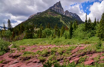
- Red Rock Canyon is named for the several, thick, sedimentary beds of red argillite rock.
- In 1927, a 250-passenger boat, the 'M.V. International', was built and began operating on Upper Waterton Lake. Visitors can still experience a boat tour of Upper Waterton Lake on this historic vessel.
- The Crandell Lake loop is a natural passage between Waterton’s two main valleys. The trail follows an old wagon road that was used at the turn of the century for access to oil discovery sites in the Cameron Valley.
- In 1908, in Blakiston Valley, traces of copper were found, and a small claim was worked for a short time. Coppermine Creek is named for that claim.
- The Tamarack Trail is the longest trail in the park at 36.4 km. Nearly 23 of its 36 km is less than a kilometre from the crest of the Great Divide.
- The Cameron Lakeshore trail visits the extreme south-west corner of Alberta. It’s a place where 3 parks, 2 provinces and 2 countries meet.
- The Bear’s Hump trail is one of the steepest short hikes in the Canadian Rockies, climbing 225 m in 1.4 km.
- The paved, non-motorized, multi-use Kootenai Brown Trail was constructed between Linnet Lake and the Park Gate. Minister Jim Prentice officially opened the trail on October 9, 2010.
- In 2001, Parks Canada permanently closed the Wishbone, Crypt Landing and Crypt Lake backcountry campgrounds to improve safety for both people and bears.
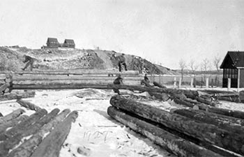
- The Waterton School opened in 1927. It closed in 1995, due to low enrolment.
People
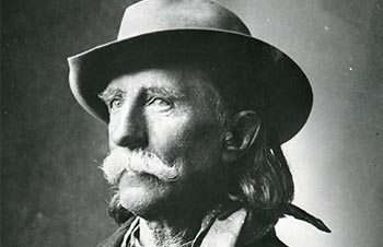
- Waterton was named after 19th century British naturalist Charles Waterton.
- Lt. Thomas Blakiston was the first European to explore the area around Waterton. The tallest peak in Waterton, Mount Blakiston, was named after him.
- John George 'Kootenai' Brown was the first settler in the park area, the first game guardian and fisheries inspector, and became the first park official in 1911.
- 'Kootenai' Brown is buried next to his two wives, Olivia and Isabella, near Lower Waterton Lake.
- F.W. Godsal, a Cowley rancher, was the first to take a major step towards protection of Waterton. He sent a proposal to Ottawa in 1893 recommending that the Waterton Lakes area be set aside as a national park.
- John Lineham was a former member of the North West Territories legislative assembly and once owned 647.5 ha of land in the Akamina Valley. That land was later returned to the Government of Canada.
- In 1898, William Aldridge, who lived on the shore of Middle Waterton Lake, was one of the first to capitalize on the Cameron Creek oil seepage.
Indigenous peoples
- Waterton Lakes National Park is part of the traditional territory and a place of significance for the Niitsitapi (Blackfoot) and other Indigenous peoples.
- The traditional Blackfoot name for Waterton Lakes - Paahtómahksikimi (BUCK-toe-MOCK-sick-ih-mee) - means the inner sacred lake within the mountains.
- The earliest evidence of hunting and gathering among Waterton’s lakes and mountains stretches back more than 10,000 years. In these rich valleys, Indigenous peoples, including Niitsitapii (Blackfoot) and K’tunaxa peoples, hunted bison and collected plants for food and medicine.
- The name Akamina comes from the Kootenai word for valley or bench land.
- Waterton Lakes National Park partially surrounds a timber reserve belonging to the Kainai.
- Crandell Mountain was formerly called Great Bear or Grizzly Medicine Mountain by the Piikani.
- Maskinonge originates from the Ojibwa word for ‘great fish’ and refers to the largest member of the pike family found in the Great Lakes region in Eastern Canada.
- Josie Weninger became Canada’s first Metis woman to head a national park when she became Waterton’s superintendent in 1997.
- Once huge herds of plains bison roamed this area and Indigenous peoples used the steep stream bank along Blakiston Creek as a buffalo jump for harvesting these animals.
- A travel route called the Buffalo Trail used by Indigenous peoples for thousands of years crossed south Kootenay Pass and followed Blakiston Creek past the mouth of the Red Rock Canyon. Seasonal hunting camps have been found near the Canyon dating to 8,000 years ago.
Designations
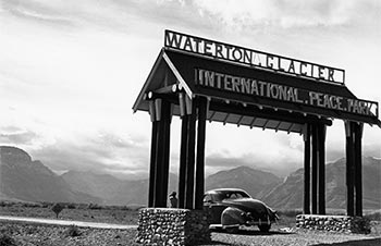
- Waterton Lakes National Park is part of the Waterton-Glacier International Peace Park (IPP), created in 1932 as a symbol of peace and goodwill between Canada and the United States.
- The Waterton-Glacier International Peace Park (IPP) is 4,556 km2 in size.
- In 1978, the first International Peace Park Hike was held. It is led by a US Park Ranger and a Canadian Park Interpreter.
- The Waterton-Glacier IPP became a UNESCO World Heritage Site in 1995.
- The Waterton Biosphere Reserve (WBR) was designated in 1979.
- Waterton was Canada’s second biosphere reserve and the first Canadian national park to take part in this UNESCO program.
- The park has two national historic sites located within its boundaries: The Prince of Wales Hotel NHS (designated in 1995) and the First Oil Well in Western Canada NHS (designated in 1968).
- In 2017, Waterton-Glacier International Peace Park was designated an International Dark Sky Park by the International Dark Sky Association (IDA).
- This is the first IDA designation in the world to cross an international border.
Landforms
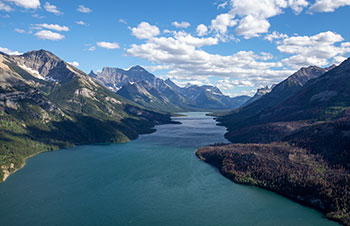
- Upper Waterton Lake is the deepest lake in the Canadian Rockies at 148 m.
- The Park’s highest peak, Mount Blakiston, is 2,940 m above sea level.
- Waterton has some of the oldest, exposed sedimentary rock in the Rocky Mountains.
- The Waterton Lakes Chain - Upper, Middle and Lower Waterton Lakes and the Maskinonge - is one of the most distinguishing and dominant features of the park. They make up almost two thirds of the total water surface area in the park
- Waterton Lakes National Park receives Alberta's highest average annual precipitation.
- The average elevation of summits in Waterton is lower than farther north in the Rockies.
- Three lakes lie in both Waterton and Glacier national parks: Upper Waterton, Cameron Lake and Crypt Lake.
- There are 80 lakes and ponds in Waterton Lakes National Park and over 100 km of rivers and streams.
- The two watersheds in Waterton Lakes National Park are the Waterton and Belly rivers which are tributaries to the Saskatchewan River. Both eventually empty into Hudson Bay.
- The Precambrian rock exposed at Cameron Falls is 1.6 billion years old, making it the oldest exposed bedrock in the Alberta Rockies.
- The rock layers in Waterton are primarily eroded sediments laid down particle by particle at the bottom of an ancient sea which existed 1,500 million years ago.
- A noticeable black band seen on the face of some park mountains, called the Purcell Sill, is igneous rock.
- The park's unusual red and green rocks are shaly siltstones called argillite. The red rocks contain oxidized iron; the green rocks contain unoxidized iron.
- Post-glacial features in Waterton Lakes National Park include the alluvial fans of Blakiston Creek and the townsite.
- You can see Glacier National Park’s highest peak from the Waterton townsite. Mount Cleveland (3,194 m) lies on the east side of Upper Waterton Lake.
- Alderson Lake is the deepest of Waterton’s high country lakes at 60 m.
- Crypt Lake has no surface outlet. It drains through a karst system and is known as a sink lake.
- Lower Waterton Lake occupies a trough formed when a huge block of ice broke away from the main glacier in the Waterton Valley and became stationary.
- At Red Rock Canyon you can see fossil formations known as stromatolites.
- Around 95% of bedrock in Waterton is sedimentary.
Nature and wildlife
- The park is part of the Crown of the Continent ecosystem, a place with unusually diverse physical, biological and cultural resources. The ecosystem is one of the narrowest places in the Rocky Mountain chain.
- More than half of Alberta’s plant species are found in Waterton.
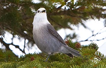
- Waterton Lakes National Park is home for more than 60 species of mammals, 250 species of birds, 24 species of fish and 10 species of reptiles and amphibians.
- Waterton Lakes is the only Canadian national park that preserves foothills fescue grasslands.
- Waterton Lakes National Park has many rare plants. About 100 are provincially rare and about 35 are nationally rare.
- Waterton's wild members of the cat family - cougars, lynx and bobcats - are known for their superb hunting skills.
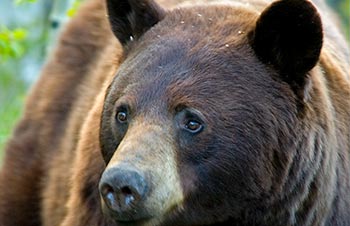
- Waterton's large predators include wolf, coyote, cougar, grizzly bear, and black bear.
- Several different ecological regions meet in Waterton - with prairie plants of the Great Plains, Rocky Mountain plants from northern areas, and coastal plants from the Pacific Northwest all overlapping.
- In Waterton, precipitation varies greatly from valley bottom to mountain peak. For example, the area around the park gate receives an average of 76 cm of precipitation a year, while the community receives 107 cm and Cameron Lake receives 152 cm.
- Waterton’s prairie soils are underlain by glacial till, resulting in quick drainage of soil moisture.
- The Waterton-Glacier International Peace Park is one of the few places in North America where all native carnivores survive.
- Waterton has black bears and grizzly bears. Black bears are more common.
- There are no turtles, lizards or venomous snakes in Waterton.
- There are 1,270 plant species in Waterton, the most of any national park in the Canadian Rockies.
- Waterton Lakes National Park offers some of the best wildflower displays in North America.
- The highest wind speed recorded in Waterton was 161 km/h.
- There has only been one fatal bear attack in Waterton’s history which occurred on July 1, 1977.
- There are three endangered species in Waterton: Whitebark pine, Little brown bat and the Half-moon hairstreak butterfly.
- Waterton’s landscape can be divided into four different ecoregions: foothills parkland, montane, subalpine, and alpine.
- The Subalpine is Waterton's largest ecoregion, accounting for approximately 35% of its total area.
- The Alpine ecoregion accounts for almost 25% of Waterton Lakes National Park and is similar to tundra found in the arctic.
- The oldest trees in the park are subalpine larch. One at Lower Rowe Lake is over 700 years old - the oldest known in the Canadian Rockies.
- Significant wetlands in Waterton Lakes National Park include the Maskinonge, Upper Crooked Creek (Sofa) wetlands, and those located along lower Blakiston Creek.
- Elk, the second largest member of the deer family, are the most numerous large animal in Waterton.
- During fall and winter herds of hundreds of elk are often seen on the Blakiston fan or other prairie areas in the park.
- The rarest plant in the park is a minuscule fern called the Waterton moonwort which grows nowhere else on earth.
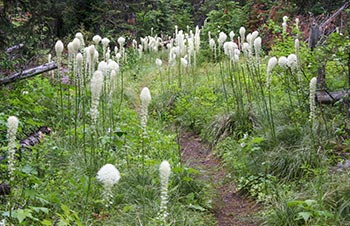
- Tall beargrass flowers are Waterton’s showiest plant. Waterton Lakes is the only Canadian national park that protects this lily. It is the unofficial emblem of the Waterton-Glacier International Peace Park.
- There are nearly 250 bird species found in Waterton.
- The park's mountain waters are cold (normally well below 15°C), high in oxygen and low in nutrients with little plant life.
Natural processes
- Natural processes greatly influence Waterton Lakes National Park and the greater Crown of the Continent ecosystem.
- In Waterton Lakes National Park, the three most critical natural processes are fire, flood and avalanche.
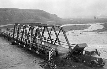
- Large floods have occurred in Waterton in 1908, 1923, 1937, 1953, 1964, 1975, 1995 and 2013.
- In the flood of 1908, Bert Riggall, a local guide and outfitter, noted that the Waterton River was almost a mile wide in places. Cameron Creek rose high enough to flood most of its fan.
- Upper Waterton Lake rose 1.2 m in three hours on June 8, 1964, causing the worst flood in the park’s recorded memory.
- Fire is as important as water, sun and wind. Fires don't just destroy, they create.
- The Sofa Mountain Wildfire (1998) and Kenow Wildfire (2017) are major wildfires in the park's history.
- The Kenow Wildfire burned 19,303 hectares (38%) of the park. 148 firefighters worked on this wildfire and 11 helicopters were used.
- The Sofa Mountain Wildfire burned 1,521 hectares of the park.
- In the year following the 2017 Kenow Fire, Cameron Falls turned black three times during heavy rain due to ash and other debris from the fire.
- In 1935, a lightning-caused wildfire started in the Boundary Creek valley, crossing into Waterton Lakes National Park on August 10. It spread as far as Bertha Creek before rain and a north wind put it out.
- The average annual rainfall at Cameron Lake is 152.4 cm, making it the wettest place in the province of Alberta.
- There are no glaciers in Waterton Lakes National Park. Glacier National Park (U.S.) to the south has several glaciers, most tucked into shadowy niches high along the Continental Divide.
- Waterton has many chinooks, which contribute to it being one of Alberta’s warmest areas in winter. Chinook winds can cause winter temperatures to rise dramatically within hours.
Related links
- Date modified :