
Maligne Lake area
Jasper National Park
At Maligne Lake you can walk the lakeshore, enjoy a forest trail or hike to the top of an easy peak. From Highway16, turn onto the Maligne Road 1.9 km east of Jasper. The lake is at road's end, 47 km from town. Check your fuel gauge; there are no gas stations on this road.
Moose Lake Loop


Trail 20 (easy); 2.7 km loop; 59 m elevation gain; 1-2 hours
Trailhead: Start on the Bald Hills Trail (see bellow), then branch left after 200 m onto the Maligne Pass Trail toward Moose Lake.
This trail stays in the woods, but the landscape is fascinating: little hills and hollows among the overgrown debris of a huge landslide. Thousands of years ago, half a billion cubic metres of rock fell from the ridge on the other side of Maligne Lake, blocking the valley and enlarging the lake considerably to its present size. The mossy, lichen-encrusted boulders seen along the trail—a natural rock garden—are part of the slide heap. Dark-brown hair lichens adorn the bare branches of lodgepole pines.
After a short section over relatively level terrain, turn left off the Maligne Pass Trail to reach Moose Lake, which lies in a hollow in the rockslide debris. From the lake the trail continues gently downhill to Maligne Lake. Keep left along the shore to return to the parking lot.
Mary Schäffer Loop
Trail 21 (easy); 3.2 km loop; no elevation gain; 1-2 hours
Trailhead: Turn in at the first parking lot at Maligne Lake. Take any path down to the shore and follow the paved trail left.
Leaving the shoreline, the trail passes through lichen-rich stands of pine, spruce and fragrant subalpine fir as it loops back to the parking lot.
Lorraine Lake and Mona Lake
Trail 100 (easy); 5.2 km return; 80 m elevation gain; 2-3 hours
Trailhead: Park as per the Bald Hills Trail, but take the obvious trail entering the woods 50 m right of the Bald Hills Trail. This is the Skyline Trail; you hike to the lakes along it.
The trail climbs gently for 2 km through a lodgepole-pine forest, then a short spur leads to Lorraine Lake on the left. If you continue one-half kilometre along the Skyline, you will meet another spur trail that leads to Mona Lake on the right. Both these lakes lie in hollows in landslide debris (see Moose Lake Loop, previous item).
If you're after a longer walk, Evelyn Creek is 2.4 km farther. There are picnic tables on the other side of the bridge. Beyond the creek, the trail switchbacks up to treeline and reaches Little Shovel Pass at km 10.3.
Opal Hills Loop

Trail 22 (difficult); 8.2 km loop; 460 m elevation gain; 4-6 hours
Trailhead: Turn left into the first parking area at the lake, then left again and uphill to reach the farthest of the three lots. The trail begins at the northeast corner.
Hikers work hard along this trail, gaining 460 m of elevation in only 3 km, but they are rewarded with spectacular views of the Maligne Valley and an abundance of alpine wildflowers.
A short distance from the parking lot the trail crosses a large, wet meadow containing several mounds. Each of these was originally a large limestone boulder, now completely shattered by freezing and thawing of water drawn up into cracks in the rock.
The trail climbs steeply for 1.5 km through a forest of lodgepole pine to a junction. Take the left branch (less steep) through forest and flowery subalpine glades to treeline, where the trail flattens past two hill-size piles of landslide debris from Opal Peak above. Listen for the trilling of Brewer's sparrows, which nest in the willows here. Beyond the second pile the trail loops back to the right and steeply down to reach the junction.
Bald Hills
Trail 23 (difficult); 10.4 km return; 500 m elevation gain; 4-6 hours
Trailhead: Pass by the first turnoff to the lake, go past the buildings, cross the Maligne River, go to the end of pavement and turn left into the large parking lot. The trail, which was once a fire road (route to a fire lookout), is the gated track heading right where you turned left into the lot.
The elevation gain of nearly 500 m is well worth the effort required. The trail climbs steadily through an open forest of lodgepole pine. At km 3.2, keep left (uphill, fairly steep) rather than taking the flat trail branching right.
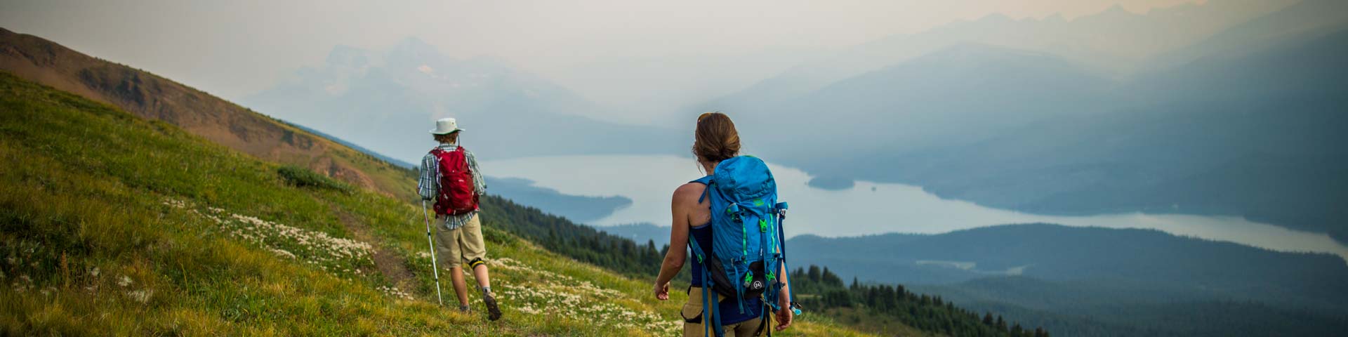
At the end of the old fire road (elevation 2170 m, once the site of a lookout station at treeline), you get a panoramic view of Maligne Lake, with triangular Samson Peak (3077 m) obvious partway down the far shore, and (counterclockwise), Leah Peak (2810 m), reddish-brown Opal Peak (2740), the gray Queen Elizabeth Range, the Maligne Valley, the brownish Maligne Range and, close by, the northernmost of the Bald Hills.
A path continues southward to the foot of this small, rounded mountain, then ascends steeply to the summit, elevation 2300 m. Look for hardy high-alpine flowers blooming on the stony tundra. Extensive alpine meadows to the south are very flowery in late July and early August. You may be standing in a spot where caribou once cooled themselves on a snowbank while avoiding pesky bugs.
- Date modified :