
Unauthorized trail closure : Ross Lane area
Prince Edward Island National Park
Parks Canada wishes to advise you that new measures are in place to address unauthorized trails in the central sector of PEI National Park.
Parks Canada has made efforts to reduce pedestrian use of unauthorized trails in the park; however, these efforts have not proven effective in deterring visitors from accessing the coast from these locations. New enforcement measures have been implemented to protect the forests and dunes in this area of the park.
 Click map the enlarge
Text version
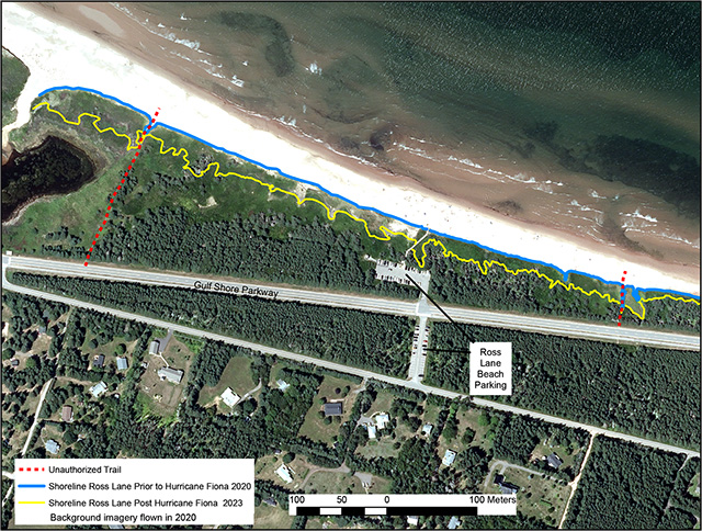
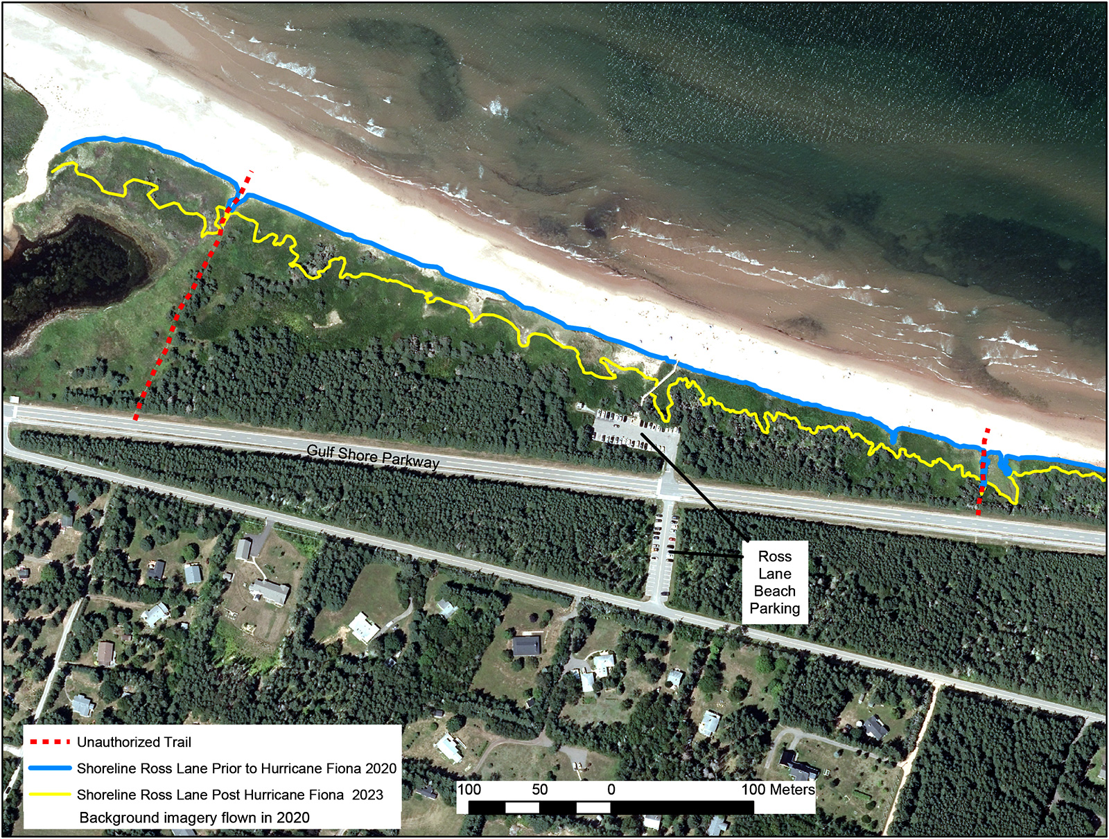
Ross Lane Shoreline Change Due to Hurricane Fiona
This aerial map shows the Ross Lane area of Prince Edward Island National Park with a focus on the impact of Hurricane Fiona on the coastline. The imagery in the background was captured in June, 2020.
Key features:
- Location and Orientation:
- The map is oriented with north at the top.
- The shoreline runs horizontally across the upper portion of the map.
- The Gulf of St. Lawrence is to the north (top) and Route 6 (a major roadway) runs east-west in the middle of the map.
- Residential areas are shown in the southern portion of the image (bottom of the map).
Beach and Shoreline:
- Two shoreline positions are shown:
- Pre-Hurricane Fiona (2020): marked with a blue line.
- Post-Hurricane Fiona (2023): marked with a yellow line.
- The 2023 shoreline (yellow) is noticeably further inland than the 2020 shoreline (blue), indicating significant coastal erosion due to Hurricane Fiona.
Trails:
- Red dashed lines indicate unauthorized trails cutting through vegetation from the road and residential area to the beach.
- These unauthorized trails are present on both the western and eastern ends of the map.
Infrastructure:
The Ross Lane Beach parking area is marked in the center of the map, directly north of Route 6, with a paved access road leading to the beach.
Legend:
- The map includes a clear legend indicating the following:
- Red dashed lines: Unauthorized Trails
- Blue line: Shoreline Ross Lane Prior to Hurricane Fiona (2020)
- Yellow line: Shoreline Ross Lane Post Hurricane Fiona (2023)
- Background imagery flown in 2020
Scale:
A scale bar at the bottom of the map provides reference distances in meters, from 0 to 100 meters.
Interpretation:
The map visually illustrates the erosion caused by Hurricane Fiona, which moved the shoreline landward, reducing beach width and altering coastal access. The presence of unauthorized trails suggests ongoing human impact on sensitive dune environments. This information supports coastal protection and visitor management efforts.
There are currently two unauthorized trails in the central sector of PEI National Park being used to access the Ross Lane beach area. The two unauthorized trails identified in red in the map below intersect the vegetated forest and cross the sensitive dune ecosystems.
The coastal forests and dune ecosystems along the north shore are priority areas for protection in PEI National Park. Authorized trails and dune crossings located throughout the park help ensure that the vegetation in wilderness areas remains intact and available as habitat for the animals that call the park home.
Shoreline changes and unauthorized trails at Ross Lane
While Parks Canada understands the desire for park residents and local visitors to access their favourite parts of the park in a way that is most convenient and enjoyable to them, unauthorized trails negatively impact park ecosystems. Closing and restoring unauthorized trails will support improvement of the integrity of PEI National Park’s coastal ecosystem and improve the resilience of the dunes and coastline to climate change impacts, such as increased coastal erosion and inland flooding.
As of June, 2025, Parks Canada will be implementing a Field Unit Superintendent’s closure of the two unauthorized trails noted above. These closures will include barricades and will be in effect year round. Park Wardens will be monitoring any use of unauthorized trails in this area of the park. The fine for entering and travelling in a restricted area under the National Parks General Regulations Section 7(4)(c) is $150. Over the next 2 years, Resource Conservation team members will be working to restore and replant these areas of the park.
This season and future forward, local park residents and visitors should access the coast using dune crossing infrastructure at Ross Lane beach or via adjacent Stanhope Cape or Stanhope Main beaches.
Parks Canada thanks you in advance for your support and cooperation. Should you have any questions, please reach out to: pnipe-peinp@pc.gc.ca.
Related links
- Date modified :