
Temporary closures at Parks Canada places on PEI
Prince Edward Island National Park
* When visiting PEI National Park, please respect all signs.
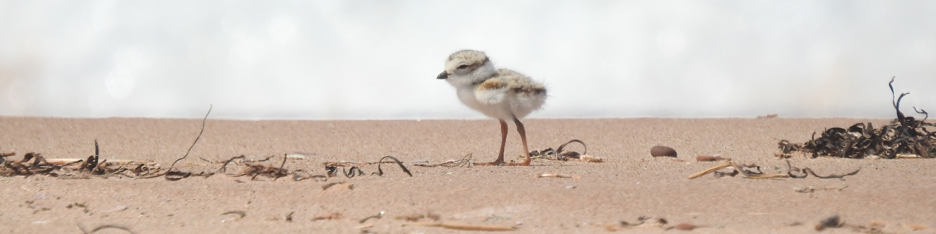
Beach Closures for Piping Plover
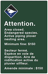
When Piping Plover are present and breeding, signs are posted and the areas are closed to all public use and travel pursuant to section 7(1) of the National Park General Regulations. Anyone found in violation of this prohibition may be prosecuted under Section 7(4)(c) of the General Regulations. The minimum fine for a violation of this prohibition is $150.
Cavendish - North Rustico
- No closures
Brackley - Dalvay
Covehead West
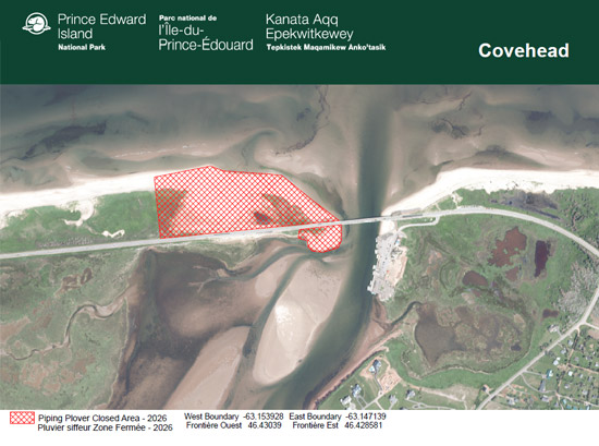
Reason for Closure: The following area has been closed for dune restoration management and critical habitat use for the endangered Piping Plover (Charadrius melodus melodus) and the threatened Gulf of St. Lawrence Aster (Symphyotrichum laurentianum). The area is closed to ALL PUBLIC USE AND TRAVEL by order of the superintendent, Prince Edward Island National Park of Canada pursuant to section 7(1), General Regulations of the National Parks Act. Beginning May 25, 2026, until further notice.
Covehead West: The dune, pond and beach to mean high tide immediately west of Covehead Bridge from the northern coordinates of 46.430831, -63.15391 and 46.43021, -63.148352 and the southern coordinates of 46.429046, -63.153884 and 46.428548, - 63.147077. This closure extends to mean low tide along the north shore and mean high tide along the south shore.
Robinsons Island
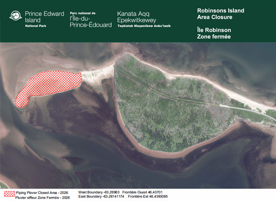
Reason for Closure: The following areas are nesting habitat for an endangered species, the Piping Plover (Charadrius melodus melodus). When Piping Plover are present and breeding, signs are posted and the areas are closed to ALL PUBLIC USE AND TRAVEL by order of the superintendent, Prince Edward Island National Park of Canada pursuant to section 7(1), General Regulations of the National Parks Act. Beginning May 27, 2026, until further notice.
Robinsons Island: All of the sandspit to the western tip of the island from the coordinates between latitude 46.43701, longitude -63.26963 and latitude 46.4393085, longitude -63.26141174. This closure extends to mean low tide along the north shore and mean high tide along the south shore.
Blooming Point Sandspit
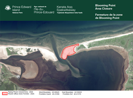
Reason for Closure: The following areas are nesting habitat for an endangered species, the Piping Plover (Charadrius melodus melodus). When Piping Plover are present and breeding, signs are posted and the areas are closed to ALL PUBLIC USE AND TRAVEL by order of the superintendent, Prince Edward Island National Park of Canada pursuant to section 7(1), General Regulations of the National Parks Act. Beginning June 1, 2026, until further notice.
Blooming Point Sandspit: The sandspit from Tracadie Bay to the Gulf of St. Lawrence between the coordinates longitude -63.00645; latitude 46.41096 and longitude - 62.99693; latitude 46.41576 to mean high tide.
Greenwich
Greenwich Tip
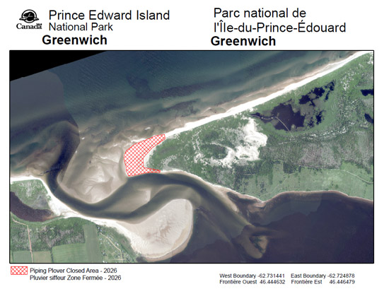
Reason for Closure: The following areas are nesting habitat for an endangered species, the Piping Plover (Charadrius melodus melodus). When Piping Plover are present and breeding, signs are posted and the areas are closed to ALL PUBLIC USE AND TRAVEL pursuant to Section 2(1)( e) of the Prince Edward Island Trespass to Property Act. Beginning May 29, 2026, until further notice.
Greenwich Beach: The sandspit at the tip of the Greenwich peninsula from the following coordinates: western boundary longitude -62.731441and latitude 46.444632; and eastern boundary longitude -62.724878 and latitude 46.446479 to mean low tide.
Greenwich Beach
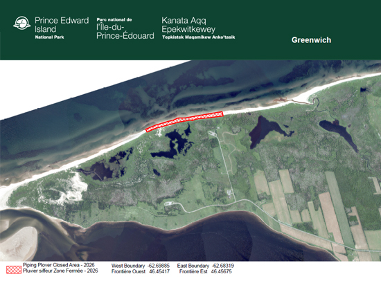
Reason for Closure: The following areas are nesting habitat for an endangered species, the Piping Plover (Charadrius melodus melodus). When Piping Plover are present and breeding, signs are posted and the areas are closed to ALL PUBLIC USE AND TRAVEL pursuant to Section 2(1)(e) of the Prince Edward Island Trespass to Property Act. Beginning June 19, 2026 until further notice.
Greenwich Beach: A section of beach between the Greenwich Dune Beach stairs and the Greenwich Main Beach stairs. Between the following coordinates: western boundary latitude 46.45417, and longitude -62.69885; and eastern boundary latitude 46.456744, and longitude -62.683186 to mean low tide.
Beach Closures for Bank Swallows
The following areas are nesting habitat for a threatened species, the Bank Swallow (Riparia riparia). When bank swallows are present and breeding, signs are posted and the areas are closed to ALL PUBLIC USE AND TRAVEL by order of the superintendent, Prince Edward Island National Park of Canada pursuant to section 7(1), General Regulations of the National Parks Act. The minimum fine for a violation of this prohibition is $150.
Current closures: No closures
Related links
- Date modified :