
Connecting with the ocean
We are all connected to the ocean. From mountaintops to the seafloor, water always flows towards the ocean. Explore how Parks Canada protects aquatic life and celebrates marine cultural heritage from rivers and lakes to estuaries and seas.
On this page
- Your ocean connection
- Exploring iconic coastal landscapes
- Conserving marine ecosystems
- Collaborating with Indigenous communities
- Protecting marine cultural heritage
- Take action to protect the ocean
- Ocean Week events
Your ocean connection
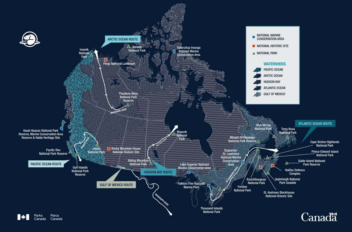
From coast to coast to coast, all rivers join the sea. Find out which ocean basin you are connected to by following the waterways in your area on this map. Note how some of the locations administered by Parks Canada are located along the way.
View larger image
Map description
A map of Canada showing the types of sites administered by Parks Canada that fall along a water route within a major watershed. The map illustrates five major watersheds across Canada, shown in different textures. Each watershed has a major water route. The water route appears as an arrow that represents a major river that flows from inland to an ocean.
From left to right:
The Pacific Ocean watershed contains the Pacific Ocean Water Route. The map shows the Fraser River starting at Jasper National Park. It flows into the Pacific Ocean (Georgia Strait) through multiple channels. Gulf Islands National Park Reserve and Pacific Rim National Park Reserve are situated along the Pacific Ocean.
The Arctic Ocean watershed contains the Arctic Ocean Water Route. The map shows the McKenzie River starting at Thaidene Nene National Park Reserve. It flows past Pingo National Landmark and Ivvavik National Park into the Arctic Ocean. Aulavik National Park and Tallurutiup Imanga National Marine Conservation Area are also located along the Arctic Ocean.
The Hudson Bay watershed contains the Hudson Bay Water Route. The map shows the Nelson River starting at Riding Mountain National Park. It flows past Wapusk National Park into the Hudson Bay.
The Gulf of Mexico watershed contains the Gulf of Mexico Water Route. The map shows the Mississippi River watershed within Canada. It flows all the way into the Gulf of Mexico.
The Atlantic Ocean watershed contains the Atlantic Ocean Water Route. The map shows the St. Lawrence River starting at Fathom Five National Marine Park in the Great Lakes. Lake Superior National Marine Conservation Area also shares the Great Lake waters. The water route flows down the St. Lawrence River past Thousand Islands National Park, Saguenay-St. Lawrence National Marine Conservation Area, Mingan Archipelago National Park Reserve, and Forillon National Park. It empties into the Gulf of Saint Lawrence, where Kouchibouguac National Park, Prince Edward Island National Park, Gros Morne National Park, and Cape Breton Highlands National Park are situated along. The Gulf then empties into the Atlantic Ocean. The following Parks Canada administered sites are along the Atlantic Ocean: Terra Nova National Park, Sable Island National Park Reserve, Halifax Defence Complex, Kejimkujik National Park Seaside, and St. Andrews Blockhouse National Historic Site.
Water is essential for life. Canada is a water nation with three major coastlines and five main ocean watersheds that connect us to the ocean. The purpose of this map is to show how a droplet of water, no matter where it falls on land, can and will reach the ocean.
Note that this map is an artistic representation of the major watersheds of Canada. It is not intended to be used as a geographic tool.
Exploring iconic coastal landscapes
Parks Canada is responsible for protecting nationally significant examples of marine natural and cultural heritage and sharing the stories of these treasured places.
In person
Parks Canada provides Canadians with opportunities to explore and enjoy iconic coastal destinations across the country. Connect with the ocean by visiting one of these special places:
- Visit a National Marine Conservation Area
Each national marine conservation area is a gateway to nature and adventure. Watch seabirds, kayak around islands, explore tidal pools, and more. - Explore magical beaches
Golden beaches, turquoise waves and sun-warmed waters. Where will your adventures take you this year? Get inspired with these beautiful beach picks. - Navigate through historic canals and waterways
Here's your chance to create unforgettable memories, surrounded by the sights and sounds of these historical routes. - Go on a paddling adventure
From canoeing to paddle boarding, ways to explore coastlines at Parks Canada administered places are endless. Which one will you choose?
From home
Canada has the longest coastline in the world, over 240 000 km! Connect with some of the natural and cultural treasures along this coastline by trying out these activities:
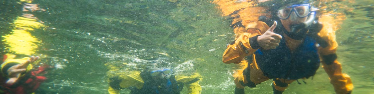
- Dive along shipwrecks, paddle with salmon, and swim in a kelp forest through this selection of some of our best marine videos.
- Colour Parka under the sea colouring sheet .
Conserving marine ecosystems
Canada is home to rich marine ecosystems. Parks Canada contributes to protecting this biodiversity and strives to conserve 25% of marine and coastal areas by 2025, working toward 30% by 2030. This work is done in collaboration with partners, including Indigenous Peoples, provinces, and territories.
Find out how Parks Canada and partners protect underwater life:
- Invasive species: aquatic ecosystems under stress at Parks Canada
Parks Canada and partners are using innovative ways to tackle aquatic invasive species. - More national marine conservation areas for healthier environments, communities, and livelihoods
Parks Canada is leading and supporting the creation of 10 new national marine conservation areas (NMCAs) by 2025. - Salmon recovery in Fundy National Park
Wild salmon have disappeared from the Bay of Fundy region. Parks Canada is working with its partners to bring salmon back to Fundy Rivers. - Restoring a quiet environment for whales
Canada’s protected waters are home to many at-risk whales. Keeping waters as quiet as possible is key for their survival. - Impede the Reed Project
Have you ever looked along a roadside or shoreline and noticed a tall, leafy grass growing over your head? You were looking at a reed. - Environmental DNA at Parks Canada
Parks Canada is using eDNA across the country to help monitor and restore healthy ecosystems. - Blue Carbon on the West Coast
Parks Canada scientists are studying the ability of eelgrass and salt marshes to absorb carbon dioxide, a major greenhouse gas. - Creatures of the deep (and shallows)
Strange and wonderful wildlife inhabit the national marine conservation areas of Canada. This story map allows you to dive along these creatures.
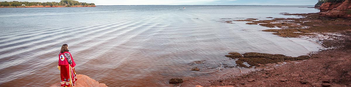
Collaborating with Indigenous communities
Indigenous peoples have a role to play in managing, protecting, and conserving marine areas. Parks Canada is working closely with Indigenous partners to weave Indigenous knowledge and values into marine conservation programs. Learn more about the role of Indigenous knowledge and leadership in the protection of nature and culture.
- The return of the sea otter
Kuu (sea otters) are returning to Gwaii Haanas after a long absence, sending out ripples of change across both the ecosystem and the community. - Sea garden restoration
Coast Salish peoples care for their beaches using traditional practices such as removing kelp and sea lettuce, creating highly productive sea gardens. - Inuit Qaujimajatuqangit and the wrecks of the HMS Erebus and HMS Terror
Inuit knowledge passed down generations led to the discovery of these wrecks at the bottom of the Arctic Ocean. - What a national park reserve in Pituamkek (Hog Island Sandhills) means
Pituamkek, a culturally significant area for the Mi’kmaq, is home of multiple archaeological sites, rare geological formations, and ceremonial lands.

Protecting marine cultural heritage
Parks Canada is responsible for protecting nationally significant examples of cultural heritage and sharing the stories of these treasured places. From heritage rivers to lighthouses, there is an amazing array of marine places and stories to discover.
- Canadian Heritage River System
From the glacial rapids of Alsek river to the urban wanderings of the Rideau waterway, this program highlights the most outstanding Canadian rivers. - Living Landscapes of SG̱ang Gwaay: Strengthening the land and people in a changing climate
In 2018, a windstorm blew down over a hundred trees at SG̱ang Gwaay Llnagaay. The damage provided an opportunity to delve into the history of the village. Find out what stories were uncovered below the roots of these ancient trees. - Heritage Lighthouses of Canada
Lighthouses have long symbolized strength, safety and safe harbour. Explore some of the most iconic lighthouses in Canada. - Underwater archaeology
Underwater archaeologists study archaeological sites found below the surface of the water. They work in rivers, lakes and the ocean. Learn more about the underwater treasures found in Parks Canada administered sites.
Take action to protect the ocean
It's your turn to take action! Parks Canada offers several ways to get involved in protecting the ocean.
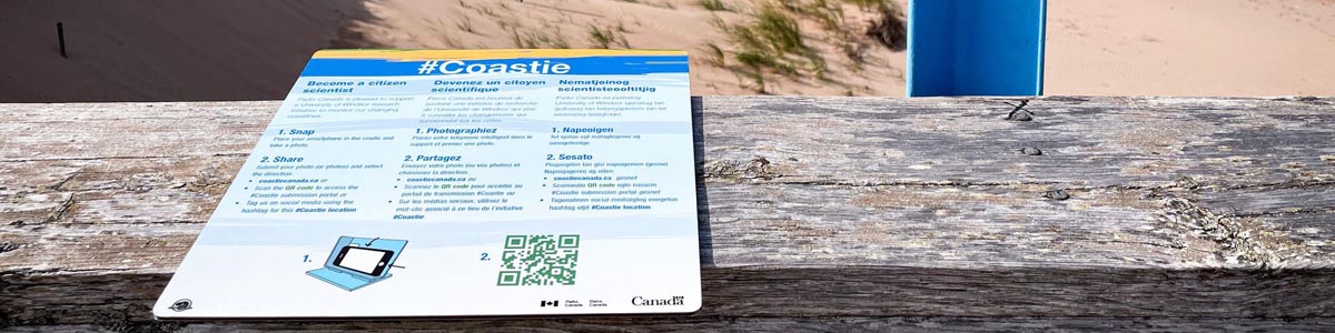
- Take a #Coastie: When you take a photo of yourself, that’s a selfie. When you take a photo of the coast, that’s a Coastie! The Coastie Initiative is a new citizen science program in collaboration with the University of Windsor. Pictures taken by visitors help us monitor coastal change over time. Take a Coastie for yourself at one of these locations:
- Prince Edward Island National Park
- Kouchibouguac National Park
- Fundy National Park
- Point Pelee National Park
- Sable Island National Park Reserve
- Kejimkujik National Park
- Cape Breton Highlands National Park
- Forillon National Park
- Gros Morne National Park
- Team up and clean up the shore
Help beat plastic pollution! Pick up a shoreline cleanup kit, gather your friends and family, and head for the shoreline. Help Parks Canada identify sources of litter by taking part in this citizen science initiative. - Explore over 100 sites listed on The Whale Trail to learn more about shore-based whale watching.
- Eat sustainable seafood, using guidelines like Ocean Wise.
- Use environmentally-friendly products to reduce ocean contamination.
- Learn how to navigate in whale habitat.
Come celebrate Ocean Week with us
From June 1 to 9, 2024, special activities to celebrate the ocean and all its waterways will take place at different Parks Canada locations. Join us to learn more about the wonderful creatures that live in the ocean—from phytoplankton to whales—and the importance of caring for the marine ecosystems. A wide diversity of fun and educational activities awaits the whole family!
Ocean Day at Fort Rodd Hill and Fisgard Lighthouse National Historic Sites
June 8, from 10:30 am to 4:00 pm
Come down to Fort Rodd Hill and Fisgard Lighthouse NHS. Parks Canada interpreters, the Southern Resident Killer Whale outreach team and several partners are ready for you to join in on the day’s festivities. You have your pick of games and activities to try. Do you want to know how a tidal pool is like a military fort; become an ally to small water creatures; create the most colourful poster celebrating Southern Resident Killer Whales; and meet local superhero Super Ollie? Join one or all programs offered throughout the day to find out how precious the ocean is and how you can help protect its inhabitants.
Cost: Regular admission
- Date modified :