
Get wild for wetlands!
Pukaskwa National Park
By Ayicia Nabigon
Frogs in the bog, wrens in the fen, and stomps in the swamp were all part of a day’s work at Pukaskwa National Park this past spring! In June, Pukaskwa’s Ecology team and two physical scientists from Environment and Climate Change Canada explored the diversity of the park’s wetlands on foot and from the sky.
Pukaskwa is home to an abundance of wetlands, ranging from graminoid fens full of tall grass-like sedges to treed bogs of stunted black spruce. Wetlands are important indicators of environmental change and ecosystem health, but given their often remote locations, they are difficult to visit and monitor. Using satellite images is one way to keep track of wetland resilience. New models are being developed by Environment and Climate Change Canada (ECCC) to identify, classify, and track wetlands using satellite and LIDAR technology. To help verify these models, myself, Courtney Irvine, Lucy Patterson, Chris Robinson, and Amir Behnamian and Morgan Hrynyk from ECCC headed into the interior of Pukaskwa National Park to collect on the ground data from the wetlands, as well as drone imagery to compare to the model data.
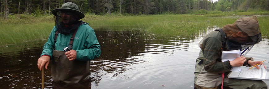
Pukaskwa may be best known for its wondrous Lake Superior coastline, however that is only a fraction of the park’s total area. The great majority of the park consists of undeveloped inland boreal forest. With one week scheduled for a wetland identification blitz, we loaded up two trucks with gear and set off for the “Northern Lakes Complex” in the interior of the park. Trucks could only take us so far, though, and we had to make several trips via ATV and using our own two feet, to shuttle our gear to the wetland monitoring sites.
Searching for an ideal spot from which to fly drones took some trial and error. We scrutinized satellite imagery looking for flat, open ground to serve as a launch pad. ECCC provided excellent guidance on selecting these spots, recommending areas with higher elevation and low tree cover to have the best connection possible as the drones captured hundreds of photos for each location. When the weather was too poor to fly, we were fighting our way through springy cedar branches and wading through waist-deep water to access wetlands. Once reached, information on peat depth, vegetation composition, and tree and shrub height was collected and used to confirm wetland classes.
One of the most rewarding parts of this work was learning about the plants that thrive in wetlands. We learned to identify the aroma of sweet gale leaves, felt the furry undersides of Labrador tea, and peered into the liquid pools of carnivorous pitcher plants. Even the dominating alder and willow species brought about their own sense of wonder, so different from the tall birch and balsam fir of the forest.
While at times the work was tiring, the blackflies relentless, and the thunderstorms fierce, being in the heart of a wetland was thrilling. These special ecosystems are invaluable sources of biodiversity and ecological resilience, and it is exciting to have contributed to a better understanding of their many forms.
- Date modified :