
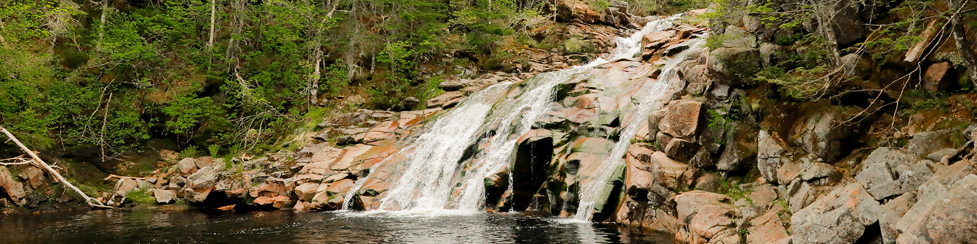
Mary Ann Falls
Cape Breton Highlands National Park
Cape Breton Highlands National Park invites you to explore its newest hiking trail, tracing part of the original Cabot Trail route from before the 1950s realignment. This revitalized trail, now exclusively for hiking, leads to the breathtaking Mary Ann Falls, a cascading waterfall and one of the park’s most beloved swimming spots.
Descend a sturdy staircase to reach the base of the falls, where cool waters and scenic views reward your effort. Along the way, discover remnants of the historic iron bridge that once crossed Mary Ann Brook, adding a touch of heritage to this unforgettable hike.
| Length | 13.9 km / 8.6 mi |
      |
| Rating | Moderate  |
|
| Elevation | 8- 166 m (26 - 545 ft) | |
| Time | 5 - 6 hours | |
| Significant features | Acadian forest, waterfall Suitable for most skill levels. Uneven trail surface in some places. |
|
| Trailhead | Parking lot on Warren Lake Road Lat: 46.713142 Long: -60.365201 |
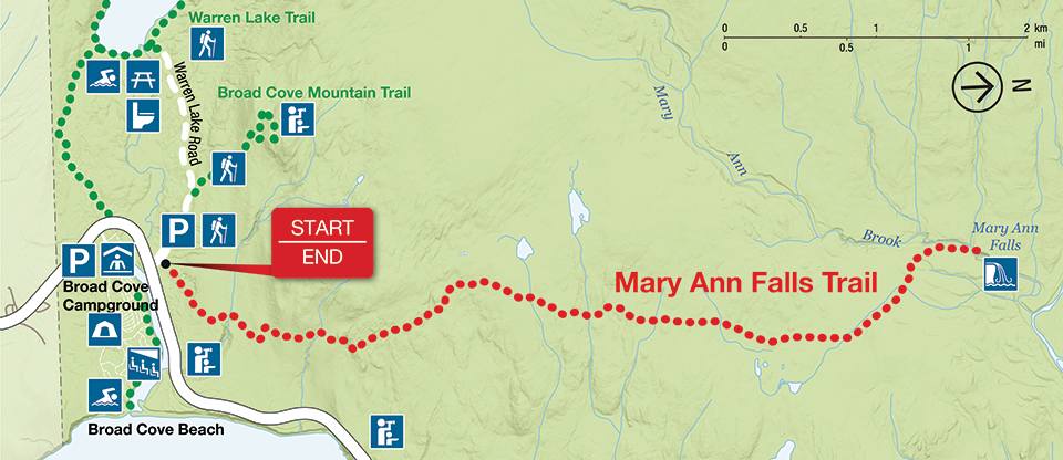
| Name | Description | Category |
|---|---|---|
| Mary Ann Falls | Waterfall | |
| Parking/Trailhead | Parking | |
| Warren Lake picnic area | Picnic area |
Hiking route
| Name | Description | Category |
|---|---|---|
| Mary Ann Falls | Trail | |
| Cabot Trail | Highway | |
| Warren Lake Road | Access route |
Map areas
| Name | Description | Category |
|---|---|---|
| Cape Breton Highlands National Park | National park |
Related links
- Acadian
- Salmon Pools
- Le Chemin du Buttereau
- Le Buttereau
- Le vieux chemin du Cap-Rouge
- Corney Brook
- Skyline
- Bog
- Benjie's Lake
- Fishing Cove
- MacIntosh Brook
- Lone Shieling
- Aspy
- Mica Hill
- Jack Pine
- Neils Brook Beach
- Jigging Cove Lake
- Green Cove
- Broad Cove Mountain
- Warren Lake
- Franey
- Clyburn Valley
- Middle Head
- Freshwater Lake Look-off
- Freshwater Lake
- Date modified :