
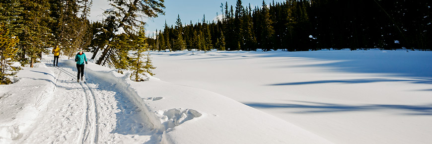
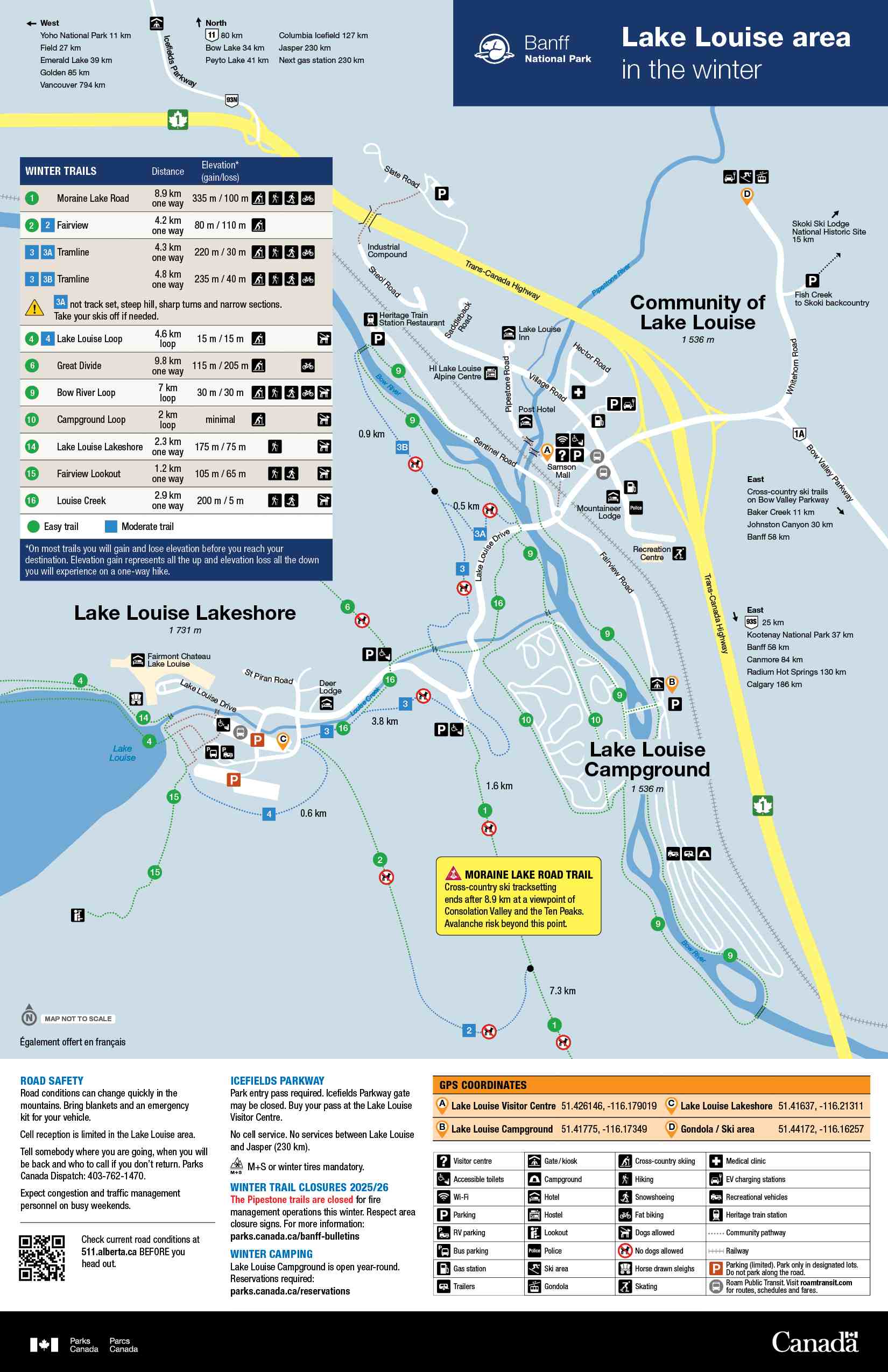
Recommended cross-country ski trails in the Lake Louise area
Banff National Park
Not all sign-posted summer destinations are safe for winter travel. If you plan to travel beyond the designated winter destinations described below, your group should be prepared with the appropriate knowledge, skills and equipment.
Winter safety
Safety is your responsibility. There are always hazards associated with outdoor recreation. Even short trips can have serious consequences.
- Ask for advice at a Parks Canada Visitor Centre for help with trip planning.
- Check current trail conditions, warnings and closures.
- Study descriptions and maps before heading out. Always choose a trail suitable for the least experienced member in your group.
- Tell somebody where you are going, when you will be back and who to call if you do not return.
- Expect that trail conditions and winter hazards may change throughout the day. Consult weather forecasts and be prepared for changing weather and emergencies.
- Winter hazards include avalanches, disorientation, thin ice, hypothermia and frostbite.
- From November to March, make sure your car is winterized. Snow tires, proper clothing, and an emergency kit are recommended. Visit 511.alberta.ca for road reports.
- In case of emergency, call 911 or satellite phone: 403-762-4506. Cell phone coverage is not reliable throughout the national park.
Recommended Packing List
- Trail guide and map: guidebooks and topographic maps are available at the Banff and Lake Louise visitor centres, and retail outlets in Banff and Lake Louise.
- Full water bottle or thermos
- High energy food
- Bear spray
- First aid kit and repair kit
- Lightweight emergency blanket, candle and lighter or waterproof matches
- Headlamp or flashlight with spare batteries
- Tuque or winter hat and gloves
- Sunscreen and sunglasses
- Hand and toe warmers
- Extra warm clothing in case of an emergency
- Cell phone or satellite communication device
Visit parksmountainsafety.ca for additional information on winter packing.
Wildlife
Although bears are denning during the winter, they can awaken at any time for short periods. Cougars, wolves and other wildlife remain active throughout the year. If you see wildlife, do not approach; give them lots of space and observe from a distance with binoculars or a telephoto lens. If tracks are observed, do not follow them towards the animal.
Be alert, make noise and carry bear spray. Learn more about keeping yourself safe.
Avalanche safety at Lake Louise
Avalanche season in the mountains extends from November to June, and even a short walk can take you into avalanche terrain. Trails with a known hazard are identified with an avalanche symbol. When travelling beyond marked trails, or past an avalanche danger sign, assume you are in avalanche country – never enter avalanche terrain without a beacon, probe, shovel and avalanche training.
Check the current avalanche forecast at a Parks Canada Visitor Centre or avalanche.ca

Stop here
If you see this sign, you are about to enter avalanche terrain.
Avalanches are possible from November until June and you could be buried or injured.
Do not proceed unless you have avalanche training and a transceiver, probe and shovel.
There are often tracks beyond these signs left by equipped parties – this does not indicate that the trail is safe. You don’t know how informed previous travellers were or what the conditions may have been at the time.
Your safety is your responsibility.
Avalanche zones at Lake Louise
Mount Fairview
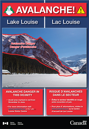
Left side of Lake Louise
November to June annually
Watch for this avalanche zone on Mt. Fairview on the left side of Lake Louise past the boat house. It may also be accessed beyond the Fairview Lookout.
This is an impressive natural feature but please enjoy it from afar.
For your safety and the safety of others, do not stand under this slide path or walk across it. Keep in mind that tracks left by others do not mean that the area is safe.
Teahouse trails
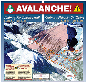
Plain of Six Glaciers and Lake Agnes including Mirror Lake
November to June annually
These very popular summer hikes are not safe for travel in the winter unless you have avalanche training and equipment.
The avalanche zones on both trails are clearly marked. Keep in mind that tracks left by others do not mean that the trail is safe.
Note: The teahouses are closed in winter. When trails begin to clear in May, check the trail conditions for current information. Your safety is your responsibility.
Saddleback Pass
Trail to Saddleback Pass
November to June annually
This trail climbs the southeast flank of Mount Fairview and crosses a prominent avalanche slide path along the way. The avalanche zone is clearly marked. Do not enter it without avalanche training and equipment.
Keep in mind that tracks left by others do not mean that the trail is safe. You don’t know how informed previous travellers were or what the conditions may have been at the time. Your safety is your responsibility.
Louise Falls
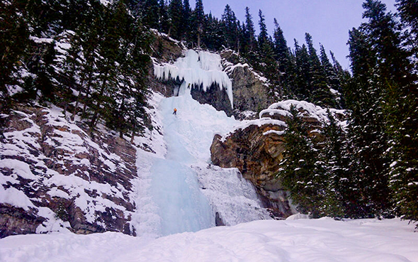
Visible from the Lake Louise Lakeshore trail at the back of the lake.
The waterfall freezes in the winter and is a popular ice climbing destination.
Enjoy the view but please avoid standing directly under Louise Falls, especially in the spring. Falling ice can be a hazard at this location.
Learn how to travel safely in avalanche country
Many excellent programs exist to help you learn to travel safely in avalanche country. Visit Avalanche Canada for a list of programs and an online introductory primer.
Visit parksmountainsafety.ca for more information on backcountry travel and how to stay safe in the mountains.
Get outside, have fun and be safe!
Trail etiquette
Trails are shared in the national park, which means you could see people fat biking while you are Winter walking, or people skiing while you are snowshoeing.
- The track set portion of the trail is for classic skiing only. The flat, groomed lane is for other users.
- When climbing, please yield the right of way to descending skiers and fat bikers.
- If you fall, move off the track as quickly as possible.
- When taking a break, step to the side, leaving room for others to pass.
- Leave no trace. Pack out everything you pack in.
- Read the trail descriptions as dogs are not permitted on certain trails. Keep dogs on leash and under physical control at all times.
Trail ratings
|
Easy |
|
|
Moderate |
|
|
Difficult |
|
| For all trails, be prepared as conditions can change quickly; easy and moderate trails can become difficult due to weather change, icy conditions or poor visibility. | |
Cross-country ski trail grooming frequency
On average, cross-country ski trails are groomed twice a week. The grooming frequency depends on snowfall and weather conditions. Check the trail conditions page for updates.
Trail summary
| Trail name | Distance | Elevation gain / loss | Activity recommended |
|---|---|---|---|
 Moraine Lake Road Moraine Lake Road |
8.9 km one way | 335 m / 100 m | |
 Fairview Fairview |
4.2 km | 80 m / 110 m | |
| Tramline |
New route: 4.3 km one way Historic route: 4.8 km one way |
New route: 220 m / 30 m Historic route: 235 m / 40 m |
|
| Lake Louise Loop |
4.6 km one way | 230 m / 230 m | |
 Upper Telemark Upper Telemark |
1.5 km one way | 20 m / 70 m | |
| Great Divide |
9.8 km one way | 115 m / 205 m | |
| Peyto |
2.2 km one way | 20 m / 90 m | |
| Lower Telemark |
3 km one way | To be determined | |
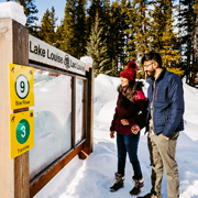
| Bow River Loop |
7 km loop | 30 m / 30 m |  |
| Campground Loop |
2 km loop | Minimal elevation gain/loss | |
| Pipestone Loop |
13.1 km loop | To be determined | Winter closure |
| Hector |
2.9 km one way | To be determined | Winter closure |
| Drummond |
2.6 km one way | To be determined | Winter closure |
| Merlin |
2 km | To be determined | Winter closure |
| Baker Creek to Protection Mountain Campground |
3.5 km one way | To be determined | |
| Protection Mountain Campground to Castle Mountain Lookout |
6.4 km one way | To be determined | |
| Castle Junction |
8.7 km of trails | To be determined |
A number of popular trails are closed this winter for fire management operations. Respect area closures in place for your safety.
More information
For more information, consult the:
Trail Map:
Lake Louise area in winter
Trail conditions:
Always check current trail conditions before heading out on the trail.
Trail descriptions
Lake Louise area trails
Moraine Lake Road
Moraine Lake Road8.9 km one way
Elevation gain: 335 m | Elevation loss: 100 m
Double trackset with multi-use skating lane
![]()
![]()
![]()
![]()
![]()
Climbing steadily, this trail includes both gently rolling and hilly stretches. Tracksetting ends at a viewpoint of Consolation Valley and the Ten Peaks.
 Avalanche hazard: Beyond the viewpoint, the road crosses large avalanche paths. Travel beyond this point requires avalanche training and equipment.
Fairview
Fairview4.2 km one way
Elevation gain: 80 m | Elevation loss: 110 m
Single trackset
![]()
![]()
A beautiful trail, the Fairview runs through sections of open clearings and snow-draped woods. It’s also possible to make a 7.5 km loop (110 m total elevation gain) using the Fairview trail, the Moraine Lake Road and the Tramline trail: the recommended direction is counter-clockwise.
Tramline
TramlineTramline (via new route)
4.3 km one way
Elevation gain: 220 m | Elevation loss: 30 m
New section not track set
![]()
![]()
![]()
![]()
![]()
Trailhead: Begin the Tramline from the Bow River parking lot on Sentinel Road, cross the bridge, take a left and follow the Bow River Loop Trail until the junction with the new Tramline route. Alternatively, start at the Lake Louise Lakeshore parking lot.
This trail includes a steep hill, sharp turns and narrow sections. Take your skis off if needed.
Tramline (via historic route)
4.8 km one way
Elevation gain: 235 m | Elevation loss: 40 m
Single trackset
![]()
![]()
![]()
![]()
![]()
Trailhead: Begin the Tramline from the Bow River parking lot on Sentinel Road. Alternatively, start at the Lake Louise Lakeshore parking lot.
This trail gently climbs from the valley bottom to the Lake Louise Lakeshore with a steady 3% grade, following the historic tramline route that once linked the train station to the Chateau Lake Louise.
Help provide wildlife with more space to move freely through the Fairview Wildlife Corridor by using the new route. Expect some steep sections and sharp turns (untracked).
Lake Louise Loop
Lake Louise Loop4.6 km loop
Elevation gain: 230 m | Elevation loss: 230 m
Double trackset
![]()
![]()
This loops features a wide open ski across frozen Lake Louise, followed by a fun “up & down” trip back through the woods – just 100 metres uphill from the lakeshore walking path. Use the Fairview – Lake Louise Connector trail to ski directly from the parking lot onto the lake.
Avalanche hazard: Beyond the back of the lake, the trail crosses large avalanche paths. Winter travel to the Plain of Six Glaciers requires avalanche training and equipment.
Upper Telemark
Upper Telemark1.5 km one way
Elevation gain: 20 m | Elevation loss: 70 m
Single trackset
![]()
![]()
This trail has several steep and technically demanding hills. If you find them too imposing, they can be avoided by taking the “Hillside” bypass. Start in front of the Chateau Lake Louise as if going to Lake Agnes, then turn right onto trail #5. Once up and behind the Chateau, ski steeply down to the Great Divide and Lower Telemark trails.
Great Divide
Great Divide9.8 km one way
Elevation gain: 115 m | Elevation loss: 205 m
Double trackset with skating lane
![]()
![]()
Mostly flat, but trending gently downhill, this trail takes you to the “Great Divide”, the B.C.–Alberta border. From here, you can continue into Yoho National Park another 3.5 km (grooming irregular) to the Lake O'Hara parking lot.
Peyto
Peyto2.2 km one way
Elevation gain: 20 m | Elevation loss: 90 m
Single trackset
![]()
This trail has a tricky starting point, off the small access road to the Brewster Stables behind Deer Lodge, but it offers a more gentle downhill to the Great Divide and Lower Telemark trails than trail #5.
Lower Telemark
Lower Telemark3 km one way
Elevation gain: To be determined | Elevation loss: To be determined
Single trackset
![]()
Park at Great Divide trailhead, ski 700 metres, and turn right at the #8 trail sign. After 3 km of twists and turns, exit back onto the Great Divide trail, and turn left to return to your vehicle.
Bow River Loop
Bow River Loop7 km loop
Elevation gain: 30 m | Elevation loss: 30 m
Single trackset
![]()
![]()
![]()
![]()
Mostly flat, following the river. To start, park near the Station Restaurant or just past the campground kiosk, or use the connecting trail from the Post Hotel or the Samson Mall.
Campground Loop
Campground Loop2 km outer loop
Elevation gain: minimal | Elevation loss: minimal
Double trackset with skating lane
![]()
![]()
![]()
This trail loops around and through the campground on gentle terrain. For access, park just past the campground kiosk.
Pipestone area trails
Pipestone Loop Winter closure
Pipestone Loop Winter closure Trail closed due to fire management operations.
For more information, view the winter trails map, fire protection and restoration projects page, or check parks.canada.ca/banff-bulletins.
Hector Winter closure
Hector Winter closure Trail closed due to fire management operations.
For more information, view the winter trails map, fire protection and restoration projects page, or check parks.canada.ca/banff-bulletins.
Drummond Winter closure
Drummond Winter closure Trail closed due to fire management operations.
For more information, view the winter trails map, fire protection and restoration projects page, or check parks.canada.ca/banff-bulletins.
Merlin Winter closure
Merlin Winter closure Trail closed due to fire management operations.
For more information, view the winter trails map, fire protection and restoration projects page, or check parks.canada.ca/banff-bulletins.
Bow Valley Parkway #1A trails
Baker Creek to Protection Mountain Campground
Baker Creek to Protection Mountain Campground3.5 km one way
Elevation gain: to be determined | Elevation loss: to be determined
Single trackset
![]()
This trail (labelled “#2" on-site) runs parallel to the parkway, and starts across the road from the Baker Creek Chalets.
Protection Mountain Campground to Castle Mountain Lookout
Protection Mountain Campground to Castle Mountain Lookout6.4 km one way
Elevation gain: to be determined | Elevation loss: to be determined
Single trackset
![]()
This trail links the other two cross country ski trails on the Bow Valley Parkway. Travel this unique path to discover a new perspective on the original autoroute through Banff National Park.
Castle Junction
Castle Junction8.7 km of trails
Elevation gain: to be determined | Elevation loss: to be determined
Single trackset
![]()
You can park for these trails (labelled #1, #2 & #3 on-site) either near the hostel, or at the Rockbound Lake or Castle Lookout trailheads.
- Date modified :