
Photo: Natalie Panek
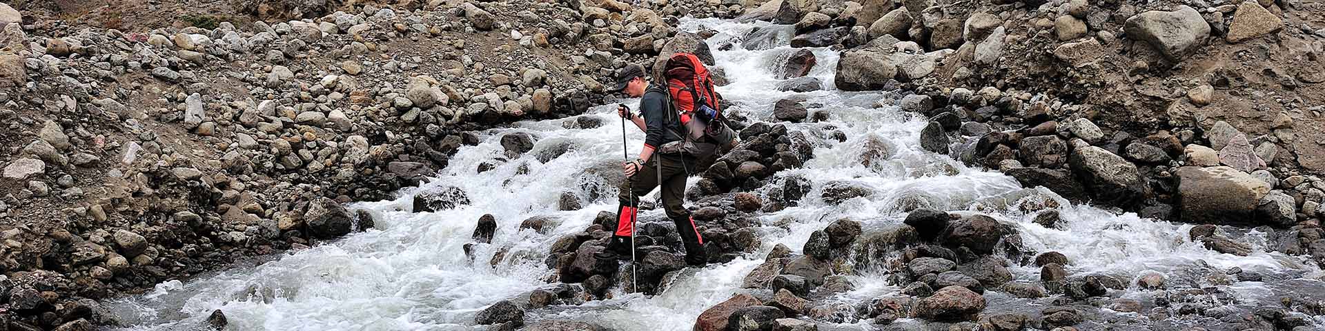
River crossings
Auyuittuq National Park
River crossings are the most significant hazard facing summer visitors. Streams and rivers in Auyuittuq are mostly glacial fed, so water volume and velocity changes throughout the day and from day to day. As the day progresses, glacial melt caused by warming temperatures increases the volume of rivers and streams. Rainfall also affects the volume and velocity of rivers and streams at any time of day. These factors make crossings unpredictable and susceptible to rapid change. Be prepared to wait out high water for hours or even days: at certain times of year, water levels are likely to significantly affect your trip route and schedule, so plan accordingly.
Historic River Flooding: last week of July through the first week of August
During the last decade, there have been visitor safety incidents related to severe flooding in Auyuittuq National Park. Although area closures are possible at any time, high water levels and the corresponding heightened risk to visitor safety have been most problematic in Auyuittuq between the last week of July and the first week of August. Visitors have been injured and have even drowned trying to cross rivers during high water levels. Others have had significant delays in their trips or needed evacuation due to river crossings becoming nearly impassable. Warm weather causing glacial melt and increased rainfall are the main factors affecting water levels. Day trips or short overnight trips may not be as impacted as through hikers when water levels rise, depending on the route. Always plan for delays.
River Crossing Tips
-
Gear considerations
- Footwear: Neoprene boots in combination with a hard gripping soles will protect your feet from the cold water and will allow you to keep your boots and socks dry.
- Hiking poles: hiking poles are essential for balance while crossing and are useful for testing water depth.
- Waterproof kayak pants with feet can provide additional protection from heat loss.
-
Deciding to cross
- Group abilities: Ensure that all group members are willing to take the risk. Consider the abilities of the weakest group member.
- Timing: Be prepared to wait hours or days until water levels are low enough for your group to make a safe crossing.
- During warm periods, water levels are generally lowest between 2 am and 7 am. Following heavy rain, water levels may continue to rise for several hours.
- Location: Assess the safest location to cross, remembering that ideal crossing locations change regularly. Consider the following:
- Water depth
- Braided areas tend to be shallower than single channels.
- Water speed
- Flatter areas tend to have slower-moving water than steeper areas.
- Hazards
- Riverbanks: may be unstable and could collapse.
- Underwater: cloudy water can obscure rolling rocks and unstable footing.
- Downstream: be aware of waterfalls, deep pools, open sea, etc.
- Water depth
-
Safe crossing techniques
- Heavy packs make crossings more difficult; you may wish to test cross without a pack or have stronger members shuttle packs.
- When crossing with a pack, unfasten waist and chest straps so you can remove your pack easily if you become pinned underwater.
- Face upstream, move with the current and use hiking poles to maintain balance.
- Consider group crossing techniques, i.e. Leader is upstream with group members in single file behind for support and to take advantage of the group’s downstream eddy.
To learn more about river safety, consider taking a swiftwater safety course before your trip.
River crossings are the most significant risk visitors face in Auyuittuq National Park. All rivers and streams are dangerous. Some streams may remain uncrossable for some members of your group. Be prepared to change your route or turn back
- Date modified :