
Wood Buffalo National Park wildfire updates
Wood Buffalo National Park
Report any wildfires or suspicious smoke to the Fire Duty Officer
867-621-0136
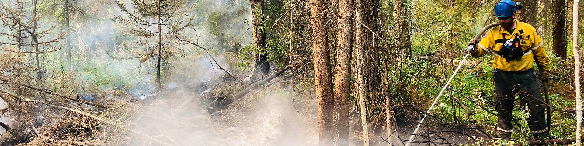
Safety is Parks Canada’s number one priority. Fire management personnel monitor Wood Buffalo National Park and surrounding areas for wildfire starts and are ready to respond if needed. Do your part and stay informed on the current fire danger status and park regulations.
Check this page regularly for updates on wildfire preparedness, response, and risk reduction activities in the park. Join our email notification lists to receive wildfire-related updates directly to your email. To be added, please email wbnpfire-feupnwb@pc.gc.ca.

2024 fire information updates
Fire Information Update – June 26, 2024 @ 1630 hrs
Updates on fires within Wood Buffalo National Park will be released on an as-needed basis.
Since the last update on June 11, there has been one new wildfire within Wood Buffalo National Park.
Fire 16 (2024WB16) is a new lightning started wildfire, located approximately 8.5 km from Highway 5, near Mile 99. This fire was detected using satellite monitoring on Monday, June 24. Two fire crews and two helicopters responded immediately and were aided by tankers, which were able to successfully drop retardant on three sides of the fire. Crews continue to work on this fire, which, earlier today, was switched from Out-of-Control status to Being Held.
Fire 3 (2024WB3) continues to be strategically managed with a long-term response plan. Structure protection on values in the area will continue to be serviced as necessary.
All other fires throughout the park are either extinguished, under control or being held thanks to the hard work of crews working on-the-ground in May and early June.
While cooler weather and steady precipitation helped in early June, the forecast for the coming week shows hot and dry conditions. Drought conditions remain throughout most of Wood Buffalo National Park. If you’re planning to be out in the park this coming long weekend, please be extra diligent with campfires, cigarette butts and other things that may start wildfires. Under current conditions, wildfires can put on significant growth in minutes.
Some closures remain in place throughout Wood Buffalo National Park due to hazardous debris and to give team members space while we work toward re-opening some of these special places. For up-to-date information on closures within the park, please visit our website here: https://parks.canada.ca/pn-np/nt/woodbuffalo/securite_safety/bulletins
For further information, contact:
Alyssa Etsell
Fire Information Officer – Wood Buffalo National Park
867-621-0764
wbnpfire-feupnwb@pc.gc.ca
Report wildfires or suspicious smoke to the Fire Duty Officer at 867-621-0136.
Fire Information Update – June 04, 2024 @ 1400 hrs
Updates on fires within Wood Buffalo National Park will be released every Tuesday unless the situation changes.
56 personnel and 6 helicopters are currently responding to wildfires within Wood Buffalo National Park. These numbers include a Parks Canada Incident Management Team and fire crews from other Parks Canada places.
Over the past week, approximately 13-24mm of rain inconsistently fell throughout the park, and temperatures have been below seasonal average. These conditions are favorable, or what we call really good firefighting conditions, and have made it easy to fly helicopters, get crews into remote locations and extinguish fire on the ground.
Since last week’s update, one new fire was detected on May 28. No fires are posing risk to values, highways or structures at this time.
Fire 15 (2024WB15) was a lightning-caused fire detected on Tuesday May 28, located near Klewi lake. This fire was found during a smoke patrol flight and was actioned upon discovery. The work crews did on the ground was successful and it is now classified as extinguished. This fire was approximately .10 hectares at time of extinguishment.
Other fires in the park:
Fire 14 (2024WB14) is a holdover fire from last year’s Pine Lake Fires detected Sunday May 26, located approximately 18 km from Pine Lake’s northern shoreline within an unburnt area. This fire is approximately 11 hectares. Due to the efforts of firefighters on-the-ground, this fire is now classified as Under Control.
Fire 12 (2024WB12) is a lightning-caused wildfire located in the Peace-Athabasca Delta region of the park, 3 km from the midwestern shoreline of Lake Claire and 3 km from the western shore of House Lake. FireSmart work and values protection is ongoing in the area. Fire crews took advantage of rainy days and have been making good progress working to put out hot spots and secure the perimeter of this fire. This fire is approximately 1,600 hectares.
Fire 13 (2024WB13) is a holdover fire 20 km south of NWT Highway 5 at Mile 99. This fire is approximately 578 hectares. Fire crews are working on-the-ground, supported by bucketing helicopters. Smoke from this fire may be visible from NWT Highway 5.
Fire 3 (2024WB3), in the southwest area of the park, is being strategically managed with a long-term response plan. Structure protection on values in the area will continue to be serviced as necessary. Currently evaluating and updating long-term management strategy. This fire is approximately 6,731 hectares.
All ten other wildfires within the park are Under Control or Extinguished.
Closures
There are many closures in place. This includes, Parsons Lake Road, Salt Plains Day Use Area and ALL recreational trails in the park. This is due to remaining public safety risk and hazardous debris. For up-to-date information on closures within the park, please visit our website here: https://parks.canada.ca/pn-np/nt/woodbuffalo/securite_safety/bulletins
Report wildfires or suspicious smoke to the Fire Duty Officer at 867-621-0136.
Weather Forecast
Over the next five days, temperatures are expected to be below seasonal average, there is potential to receive anywhere between 12mm and .5mm of rain.
For further information, contact:
Goldie Rich
Fire Information Officer – Wood Buffalo National Park
250-683-8257
wbnpfire-feupnwb@pc.gc.ca
Fire Information Update – May 28th, 2024 @ 1400 hrs
Updates on fires within Wood Buffalo National Park will be released every Tuesday, on a weekly basis, unless the situation changes.
The current fire danger level for Wood Buffalo National Park is EXTREME.
A Parks Canada Incident Management Team, along with four fire crews from other Parks Canada places, are arriving today to help with current wildfire response efforts.
There is one new confirmed fire in Wood Buffalo National Park since Saturday’s (May 25) update:
Fire 14 (2024WB14) is a new holdover fire from last year’s Pine Lake Fires detected early Sunday afternoon, located approximately 18 km from Pine Lake’s northern shoreline within an unburnt area. An initial field estimate puts the fire at approximately 8 hectares.
Two crews and two helicopters responded to this fire on Sunday, and continued work on it yesterday. Smoke from this fire may be visible from Pine Lake Road.
Other confirmed fires:
Fire 12 (2024WB12) is a lightning-caused wildfire located in the Peace-Athabasca Delta region of the park, 3 km from the midwestern shoreline of Lake Claire and 3 km from the western shore of House Lake. At the last estimate, this fire is approximately 1,300 hectares in size. On Saturday (May 25), air tankers responded and laid down lines of retardant to limit spread of the fire to the east and north. Fire behaviour on this fire was too intense for fire crews to action safely. On Sunday (May 26), a fire crew set up and ran structural protection on a nearby value in the area.
Fire 13 (2024WB13) is a holdover fire 20 km south of NWT Highway 5 at Mile 99. Fire behaviour has been too intense for fire crews to action safely. On Saturday (May 25), air tankers responded and laid down lines of retardant to slow the spread of fire to the north. This fire is approximately 400 hectares.
Smoke from this fire may be visible from NWT Highway 5. There is no risk to NWT Highway 5 or any communities at this time.
Fire 3 (2024WB3), in the southwest area of the park, is being strategically managed with a long-term response plan. Structure protection on values in the area will continue to be serviced as necessary.
All ten other wildfires within Wood Buffalo National Park are Under Control or Extinguished.
Explore our NEW interactive map and wildfire status dashboard online here: https://parks.canada.ca/pn-np/nt/woodbuffalo/nature/science_nature/fire_management/feu-foret-fire/carte-gis-map
Wood Buffalo National Park remains in an extreme drought. There is a recreational fire ban in place for the entire park. If you’re out on-the-land, please be careful with cigarette butts and other things that may start wildfires. It is very dry out there – within minutes, wildfires can grow significantly under these conditions.
Weather Forecast
Temperatures are expected to get to 22 today across the park and drop throughout the rest of the week to low-mid teens.
There is a risk of dry lightning today, with chances of thundershowers in the afternoon. For the rest of the week, rainy days are predicted, with 15-25 mm of precipitation possible. The rain is expected to clear for the weekend, accompanied by a rise in temperatures.
Environment and Climate Change Canada weather forecasts can be found here:
For further information, contact:
Alyssa Etsell
Fire Information Officer – Wood Buffalo National Park
867-621-0764
wbnpfire-feupnwb@pc.gc.ca
Report wildfires or suspicious smoke to the Fire Duty Officer at 867-621-0136.
Fire Information Update – May 24th, 2024 @ 1530 hrs
Updates on fires within Wood Buffalo National Park will be released every Tuesday, on a weekly basis, unless the situation changes.
There is one new fire within Wood Buffalo National Park.
Fire 11 (2024WB11) is a new holdover fire detected late-afternoon on Wednesday (May 22nd) during a whooping crane survey flight. This fire is approximately 2 hectares and located 6 km northwest of the Little Buffalo bridge, along the northwestern perimeter of last year’s Wood Buffalo Wildfire Complex. This wildfire is exhibiting low fire behaviour and has not grown significantly since discovery. Smoke from this fire may be visible from NWT Highway 5 – there is currently no risk to the highway or any communities.
One fire crew responded quickly after the initial fire report and began actioning the fire on arrival. They were supported with bucketing by one helicopter. The one crew and helicopter worked on Wednesday until last light and continued actioning it all day yesterday. They will return today and continue this work. The fire is burning deep in the ground, requiring considerable effort from crews to extinguish hot spots.
Fire 3 (2024WB3), in the southwest area of the park, is being strategically managed with a long-term response plan. If this wildfire starts to grow significantly, one of the response strategies will be enacted. Structure protection on values in the area will continue to be serviced as necessary.
All nine other wildfires within Wood Buffalo National Park are Under Control or Extinguished.
Explore our NEW interactive map and wildfire status dashboard online here: https://parks.canada.ca/pn-np/nt/woodbuffalo/nature/science_nature/fire_management/feu-foret-fire/carte-gis-map
Wood Buffalo National Park remains in an extreme drought. There is a recreational fire ban in place for the entire park. If you’re out on-the-land, please be careful with cigarette butts and other things that may start wildfires. It is very dry out there – wildfires can grow significantly in minutes under these conditions.
Weather Forecast
Environment and Climate Change Canada weather forecasts can be found here:
For further information, contact:
Alyssa Etsell
Fire Information Officer – Wood Buffalo National Park
867-621-0764
wbnpfire-feupnwb@pc.gc.ca
Report wildfires or suspicious smoke to the Fire Duty Officer at 867-621-0136.
Fire Information Update – May 21st, 2024 @ 1700 hrs
Updates on fires within Wood Buffalo National Park will be released every Tuesday, on a weekly basis, unless the situation changes.
There have been no new fires since the last fire information update on May 14th.
We have some great news! Eight of the ten fires within Wood Buffalo National Park are now classified as Under Control and one is classified as Extinguished.
Additional fire crews and the Parks Canada Incident Management Team that were in place have returned home. Wood Buffalo National Park resources – 2 helicopters, 16 firefighters, 5 fire specialists, 2 storespersons, 1 radio operator and 1 support staff – will continue assessing and responding to wildfires within the park.
Fire specialists have assessed and created a long-term response plan for Fire 3 (2024WB3). This holdover fire is in the southwestern area of the park, sandwiched between two 2023 fires, along the perimeter of 2023’s Davidson Lake Fires. It hasn’t put on any significant growth in the past several days. Firefighters will continue running structural protection on values at risk in the area, as needed.
The long-term response plan for Fire 3 works together with a fire analysis (which every wildfire in the park receives) and involves strategically monitoring the wildfire for growth. The plan looks at drought levels, weather conditions and more, and provides options based on different scenarios. If the fire starts to grow again, the plan outlines areas and draws out lines where different types of responses would be successful depending on water features, different tree types and changes in landscape.
For more information on where wildfires are located, their status and perimeters, you can check out our NEW fire status dashboard here: https://parks.canada.ca/pn-np/nt/woodbuffalo/nature/science_nature/fire_management/feu-foret-fire/carte-gis-map
Wood Buffalo National Park remains in an extreme drought. There is a recreational fire ban in place for the entire park. If you’re out on-the-land, please be careful with cigarette butts and other things that may start wildfires. It is very dry out there – wildfires can grow significantly in minutes under these conditions.
Closures and Fire Bans
A recreational fire ban is in place for all visitor facilities in Wood Buffalo National Park. This includes all day-use areas and Pine Lake Campground.
There are many closures within Wood Buffalo National Park that remain in place. This includes, Parsons Lake Road, Salt Plains Day Use Area and ALL recreational trails in the park. This is due to remaining public safety risk and hazardous debris. For up-to-date information on closures within the park, please visit our website here: https://parks.canada.ca/pn-np/nt/woodbuffalo/securite_safety/bulletins
Weather Forecast
Weather this week is sunny for Fort Chipewyan, Fort Smith and Garden River areas. You can expect temperatures in the high teens, but cooler evenings will remain, getting down into the single digits at night. Currently, there is no precipitation in the forecast.
Environment and Climate Change Canada weather forecasts can be found here:
For further information, contact:
Alyssa Etsell
Fire Information Officer – Wood Buffalo National Park
867-621-0764
wbnpfire-feupnwb@pc.gc.ca
Report wildfires or suspicious smoke to the Fire Duty Officer at 867-621-0136.
Fire Information Update – May 14th, 2024 @ 1300 hrs
Updates on fires within Wood Buffalo National Park will be released Tuesdays, on a weekly basis, unless the situation changes.
There are currently 10 confirmed fires within Wood Buffalo National Park.
There are 33 personnel and 5 helicopters responding to fires in the park this week, including a Parks Canada Incident Management Team.
Wood Buffalo National Park remains in an extreme drought. There is a recreational fire ban in place for the entire park. If you’re out on-the-land, please be careful with cigarette butts and other things that may start wildfires. It is very dry out there – wildfires can put on significant growth in minutes under these conditions.
New fires since the last update:
Fire 9 (2024WB9): This fire is a cluster of five holdover hot spots, located east of Fire 2, near the Peace River, along last year’s Davidson Lake Fires’ perimeter. Two fire crews have been working on these hot spots, with the goal of extinguishment along the perimeters of each spot. They have bucketing support from one medium helicopter.
Fire 10 (2024WB10): This holdover fire crossed into the southwestern corner of the park on May 12 and is being actioned by Alberta Wildfire with crews, helicopters and air support.
Other fires:
Fire 8 (2024WB8) – Peace Point Fire: This fire is located within Mikisew Cree First Nation Peace Point 222 reserve area and is currently classified as Being Held. Fire 8 remains at approximately 10 hectares and has seen no significant growth since Saturday (May 11) morning thanks to the efforts of fire crews and helicopters working the area. The goal of our efforts is to establish full extinguishment of the eastern side, within the wildland areas of the fire. Fire 8 is a suspected human-caused fire detected on May 10th, 2024.
Fire 3 (2024WB3) has most recently been mapped at 2,781 hectares and is located approximately 10 km from the southern shoreline of Isidore Lake, in the southwestern area of the park. It is a holdover fire from last year’s Davidson Lake Fires. Fire specialists continue to look at strategic containment options for further response. Firefighters will continue running structural protection on values at risk in the area.
Other confirmed fires, many of which are classified as Being Held, Under Control or Extinguished, will continue to be assessed by Wood Buffalo National Park fire personnel. Additional updates on these specific fires will be provided if needed.
Smoky conditions often accompany wildfires and are expected throughout the region today from wildfires in northern B.C. The direction and amount of smoke in an area depends on weather and changes in wind direction.
Smoke forecasts and air quality:
- Current smoke forecasts
- Canada’s Wildfire Smoke Prediction System (FireWork)
- Environment Canada Air Quality Health Index
Closures and Fire Bans
A recreational fire ban is in place for all visitor facilities in Wood Buffalo National Park. This includes all day-use areas and Pine Lake Campground.
There are many closures within Wood Buffalo National Park that remain in place. This includes, Parsons Lake Road, Salt Plains Day Use Area and ALL recreational trails in the park. This is due to remaining public safety risk and hazardous debris. For up-to-date information on closures within the park, please visit our website here: https://parks.canada.ca/pn-np/nt/woodbuffalo/securite_safety/bulletins
Weather Forecast
Weather this week is expected to remain similar with potential scattered showers throughout the afternoon. Temperatures are expected to be mid-high teens with winds generally sitting at 10-20km/hr.
For further information, contact:
Alyssa Etsell,
Fire Information Officer – Wood Buffalo National Park
867-621-0764
wbnpfire-feupnwb@pc.gc.ca
Report wildfires or suspicious smoke to the Fire Duty Officer at 867-621-0136.
Fire Information Update – May 11th, 2024 @ 1600 hrs
Updates on fires within Wood Buffalo National Park will be released Tuesdays, on a weekly basis, unless the situation changes.
There are currently 8 confirmed fires within Wood Buffalo National Park.
There are 25 personnel and three helicopters responding to fires in the park today, including a Parks Canada Incident Management Team. Tomorrow, a fourth helicopter will be added to the response.
New fires since the last update:
Fire 8 (2024WB8) – Peace Point Fire:
Last night, while Parks Canada was actioning wildfires in the southwestern region of Wood Buffalo National Park, personnel detected a suspected human-caused fire in the backyard of a Peace Point residence that quickly spread to a nearby structure and surrounding forest.
Parks Canada fire crews actioned the fire immediately. Three helicopters and three fire crews responded and worked until last light. Today, two fire crews and two helicopters returned to the area in the morning to continue suppression efforts, focusing primarily on limiting spread of the fire to the east.
An initial field assessment identified the fire at 10 hectares. At this time, the fire has not spread to the Pine Lake Road-Carlson’s Road intersection and is contained within the Peace Point Mikisew Cree First Nation reserve area.
Values at Carlson’s Landing and Moose Island are not at risk at this time, based on observed fire behaviour and predicted weather conditions. The work we are doing to supress this fire is focused on reducing any potential for growth.
Wood Buffalo National Park remains in an extreme drought. There is a recreational fire ban in place for the entire park. If you’re out on-the-land, please be careful with cigarette butts and other things that may start wildfires. It is very dry out there – wildfires can put on significant growth in minutes under these conditions.
Fire 7 (2024WB7): This fire was discovered on May 8 and was actioned by one fire crew and a helicopter immediately upon discovery. Fire 7 was a holdover fire, located approximately 10 km west of Fire 2, along the perimeter of last season’s Davidson Lake Fires. Fire 7 is now classified as extinguished.
Other confirmed fires:
Fire 2 (2024WB2) is a holdover fire from 2024’s Davidson Lake Fires and was last estimated at 95 hectares. This fire is now classified as under control. It is approximately 40 km east of Garden River in the southwestern region of the park, next to Big Slough, along the Peace River. Fire crews have been working on-the-ground since April 29 to extinguish the current perimeter 100-ft in. They are making good progress, but hot spots in this area are burning deep underground – crews have been extinguishing some that are 4-5 feet deep. Spots this deep take longer to put out as they require hard, focused work and much more effort than wildfires burning in normal conditions.
Fire 3 (2024WB3) is now estimated at 3,800 hectares and is located approximately 10 km from the southern shoreline of Isidore Lake, in the southwestern area of the park. This fire has grown because of extreme wind conditions over the last two days. It is a holdover fire from last year’s Davidson Lake Fires. Fire specialists continue to look at strategic containment options for further response. Firefighters will continue running structural protection on values at risk in the area.
Fire 4, 5 & 6: These three overwinter hot spots were discovered during NWT Fire’s infrared scanning flights. They are located along the northern perimeter of last year’s Wood Buffalo Complex wildfire and were actioned in partnership with NWT Fire. These three fires are now classified as Under Control.
Fire 1 (2024WB1): This holdover fire was spotted in February in the Lane Lakes area of the park during an aerial bison survey. It is well within the perimeter of last year’s Pine Lake Fires and causes no risk to any communities or values.
The drought conditions that spanned most of last summer carried over winter and remain in this area. It is especially important to report suspicious smoke or wildfires if you see them while travelling in the park. Call the Wood Buffalo National Park Fire Duty Officer at 867-621-0136.
Get up-to-date information on wildfires in Wood Buffalo National Park at our website here.
Closures and Fire Bans
A recreational fire ban is in place for all visitor facilities in Wood Buffalo National Park. This includes all day-use areas and Pine Lake Campground.
There are many closures within Wood Buffalo National Park that remain in place. This includes, Parsons Lake Road, Salt Plains Day Use Area and ALL recreational trails in the park. This is due to remaining public safety risk and hazardous debris. For up-to-date information on closures within the park, please visit our website here: https://parks.canada.ca/pn-np/nt/woodbuffalo/securite_safety/bulletins
Weather Forecast
Strong, gusty winds remain in the area through today, but will be decreasing in the coming days. Temperatures are expected to be slightly cooler than the past week, with the forecast showing mid-teen daytime highs. Environment and Climate Change Canada weather forecasts can be found here:
For further information, contact:
Alyssa Etsell
Fire Information Officer – Wood Buffalo National Park
867-621-0764
wbnpfire-feupnwb@pc.gc.ca
Report wildfires or suspicious smoke to the Fire Duty Officer at 867-621-0136.
Fire Information Update – May 7th, 2024
Updates on fires within Wood Buffalo National Park will be released on an as-needed basis, until the situation changes.
There are currently 6 confirmed fires within Wood Buffalo National Park. No communities are currently at risk.
Additional resources were requested last week to assist Wood Buffalo National Park in responding to current wildfires on the landscape. A Parks Canada Incident Management Team has been requested and will be arriving on Thursday May 9th.
Seven 4-person crews and three helicopters are currently responding to fires in the park.
Fire 2 (2024WB2): This holdover fire is in the southwestern region of the park, next to Big Slough and along the Peace River. It is approximately 40 km east of Garden River. It is a holdover fire from last year’s Davidson Lake Fires and was initially identified using MODIS, a satellite heat detection system, on Monday April 22. The next day, a fire specialist flew over the area in a fixed-wing plane to confirm the MODIS heat signatures as a holdover fire.
After confirming this fire, fire specialists were able to secure a helicopter to begin actioning the fire. The helicopter and fire crew members were sent to action the fire as soon as possible.
Since April 29, an additional helicopter has been added to the response. Over the weekend (May 4-6), this fire was being actioned by three fire crews and two helicopters. Yesterday, five fire crews and two helicopters contributed to firefighting efforts. A third helicopter is arriving today and will assist with initial attack response and actioning fires within the park.
Fire 3 (2024WB3): This holdover fire is also located in the southwestern region of the park, approximately 10 km from the southern edge of Isidore Lake. It is a holdover fire from last year’s Davidson Lake Fires and was initially identified on Monday April 22 using MODIS. Fire personnel are looking at strategic containment options for this fire. Structure protection, which are systems of sprinklers, hose and water pumps set up to bring up the moisture levels around values at risk, was deployed yesterday (May 6, 2024) on values in the area.
Fire 4, 5 & 6: These three overwinter hot spots were discovered during NWT Fire’s infrared scanning flights. They are located along the northern perimeter of last year’s Wood Buffalo Complex wildfire and are currently being actioned in partnership with NWT Fire. There is currently no risk to any values or communities.
Fire 1 (2024WB1): This holdover fire was spotted in February in the Lane Lakes area of the park during an aerial bison survey. It is well within the perimeter of last year’s Pine Lake Fires and causes no risk to any communities or values.
You may see smoke in other areas of the park, well within the perimeters of a fire from last year. Cameras are set up on top of both Parsons and Raven Tower, facing toward the Town of Fort Smith. These cameras send images several times per day to fire specialists, who check the photos for signs of smoke. Last week, some smoke was detected via these images. Fire personnel used a helicopter to assess the smokes and observed the smoke was coming from very small patches of unburned fuel (trees, logs, leaves, etc.), well within the perimeter of the Wood Buffalo Complex wildfire from last season, surrounded by previously burned areas.
The drought conditions of last summer carried over winter and persist in this area. It is especially important to report suspicious smoke or wildfires if you see them while travelling in the park. Call the Wood Buffalo National Park Fire Duty Officer at 867-621-0136.
Closures and Fire Bans
A recreational fire ban is in place for all visitor facilities in Wood Buffalo National Park. This includes all day-use areas and Pine Lake Campground.
There are many closures within Wood Buffalo National Park that remain in place. This includes, Parsons Lake Road, Salt Plains Day Use Area and ALL recreational trails in the park. This is due to remaining public safety risks and hazardous debris. For up-to-date information on closures within the park, please visit our website here:
https://parks.canada.ca/pn-np/nt/woodbuffalo/securite_safety/bulletins
Weather Forecast
The temperature this week in Wood Buffalo National Park is forecasted to be in the high teens, with some possible precipitation. Environment and Climate Change Canada weather forecasts can be found here:
Air Quality
Wildfire smoke will become increasingly common in the air as the wildfire season progresses and may cause older residents and people with pre-existing conditions health concerns. The Air Quality Health Index (AQHI) is a scale from 1 to 10+ designed to help you understand what the air quality around you means to your health. The higher the number, the greater the health risk associated with the air quality.
For information on air quality and risks to health, please visit this page:
Current wildfire smoke forecasts can be found here:
https://firesmoke.ca/forecasts/current/For further information, contact:
Alyssa Etsell
Fire Information Officer – Wood Buffalo National Park
867-621-0764
wbnpfire-feupnwb@pc.gc.ca
Report wildfires or suspicious smoke to the Fire Duty Officer at 867-621-0136.
This page contains an archive of information updates released by Parks Canada.
Weather Forecast
Smoke forecasts and air quality
- Current fire forecast – firesmoke.ca
- Canada’s Wildfire Smoke Prediction System (FireWork)
- Environment Canada Air Quality Health Index
Closures and restrictions
For the most up-to-date detailed information on closures and restrictions, visit our Important Bulletins page. Visit our road conditions page for current road information.
Fire bans
- There is currently no fire ban in place. Campfires are permitted in designated fire pits or fire boxes.
What is closed
- Parsons Lake Road
- Salt Plains Road and Day-Use Area
- ALL recreational trails within Wood Buffalo National Park
What is open
- Salt River Day-Use Area
- All roadside pullouts along NWT Highway 5
- Angus Day-Use Area
- Pine Lake Road
- Pine Lake Campground and Day-Use Area (Opens for the season on May 17)
- Kettle Point Road and Group Camp (Opens for the season on May 17)
For current closure information on NWT Highway 5, please visit Northwest Territories’ Highways Conditions page.
Contacts
- Wood Buffalo National Park Facebook
- Town of Fort Smith Protective Services Facebook
- Regional Municipality of Wood Buffalo (Fort Chipewyan)
- Regional Municipality of Wood Buffalo Emergency Services Facebook and Twitter
- Wood Buffalo National Park Indigenous Organizations’ websites
- NWT Emergency Alert
- NWT Fire
- NWT Fire Ban and related safety information
- Alberta Wildfire
- Alberta Emergency Alert
- Alberta Fire Ban Information
- Tune in to local radio stations
Related links
- Date modified :