
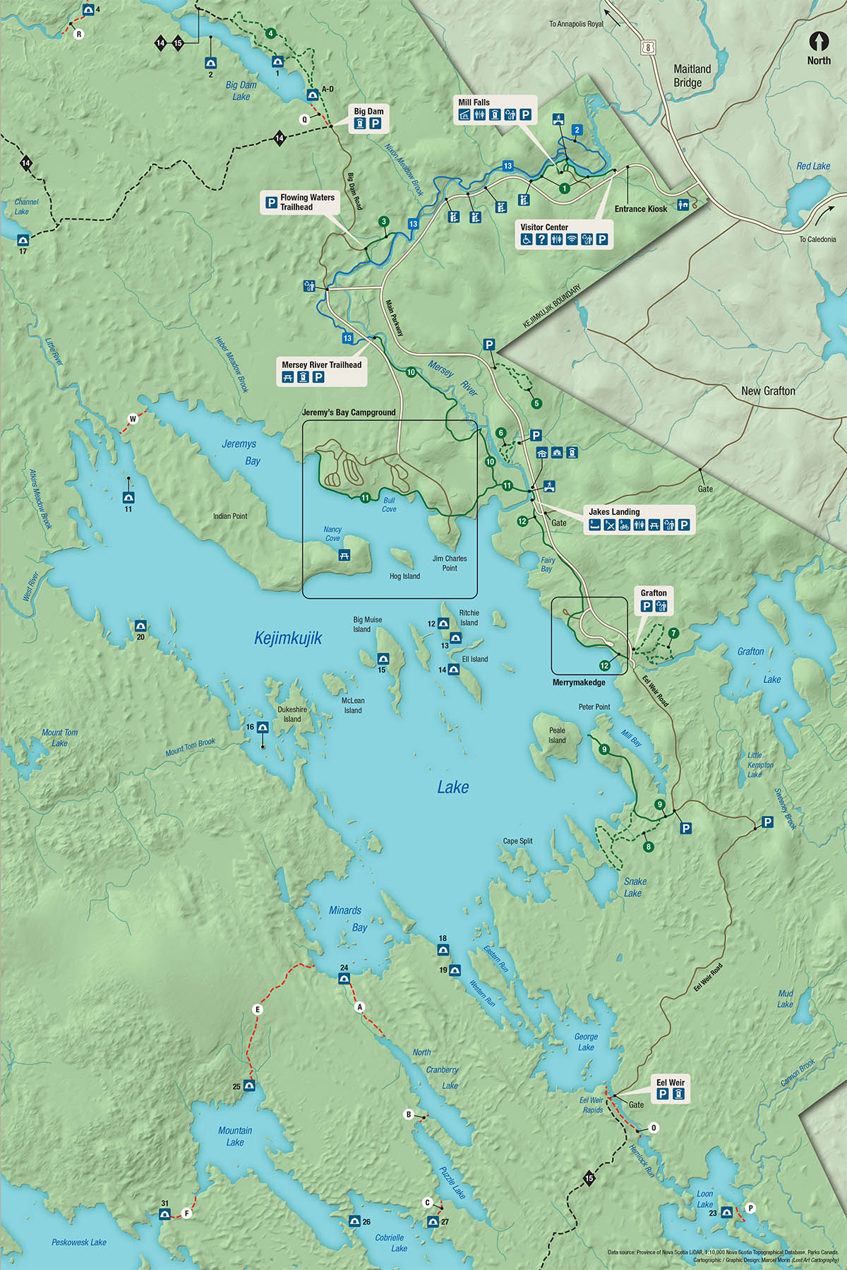
Map of Kejimkujik (summer)
Kejimkujik National Park and National Historic Site
This map shows the services and facilities at Kejimkujik National Park and National Historic Site, including services and facilities at the Visitor Centre and Jakes Landing.
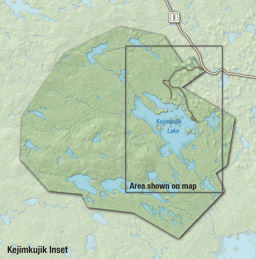
The map includes small inset maps of Jeremy's Bay Campground, Merrymakedge, and Kejimkujik.
Download (PDF, 9 MB)
Legend
Facilities and services
 Warden Office
![]() Barrier-free access
Barrier-free access
![]() Information
Information
![]() Gender-specific washrooms
Gender-specific washrooms
![]() Gender-inclusive accessible washrooms
Gender-inclusive accessible washrooms
![]() Outhouse
Outhouse
![]() Wi-Fi
Wi-Fi
![]() Parking
Parking
 Sorting station
 Pedestrian bridge
![]() Picnic shelter
Picnic shelter
![]() Picnic area
Picnic area
![]() Lookout
Lookout
![]() Playground
Playground
![]() Swimming
Swimming
![]() Sky Circle
Sky Circle
 Campfire Circle
![]() Group camping
Group camping
![]() Backcountry camping
Backcountry camping
![]() Canoe rental
Canoe rental
![]() Kayak rental
Kayak rental
![]() Bicycle rental
Bicycle rental
![]() oTENTik
oTENTik
![]() Ôasis
Ôasis
![]() Rustic cabin
Rustic cabin
![]() Yurt
Yurt
![]() No dogs
No dogs
![]() Dogs on-leash allowed
Dogs on-leash allowed
Trails and roads
 Hiking trail: Easy
 Hiking/Biking trail: Easy
 Biking/hiking trail: Moderate
 Backcountry trail
 Portage
 Paved road
 Gravel road
Frontcountry trails
| Trail | Activity | Difficulty | Distance | Type |
|---|---|---|---|---|
| 1 Mill Falls | Easy | 2 km (return) | Linear | |
| 2 Beech Grove | Moderate | 2.2 km | Loop | |
| 3 Flowing Waters | Easy | 1 km | Loop | |
| 4 Hemlocks and Hardwoods | Easy | 5 km | Loop | |
| 5 Farmlands | Easy | 1.1 km | Loop | |
| 6 Rogers Brook | Easy | 1 km | Loop | |
| 7 Grafton Woods | Easy | 1.6 km | Loop | |
| 8 Snake Lake | Easy | 3 km | Loop | |
| 9 Peter Point | Easy | 1.9 km (one way) | Linear | |
| 10 Mersey River | Easy | 3.3 km (one way) | Linear | |
| 11 Slapfoot | Easy | 3.7 km (one way) | Linear | |
| 12 Merrymakedge | Easy | 2.7 km (one way) | Linear | |
| 13 Ukme'k | Moderate | 6.3 km (one way) | Linear |
Backcountry trails
| Trail | Activity | Difficulty | Distance | Type |
|---|---|---|---|---|
| 14 Channel Lake | Difficult | 24 km | Loop | |
| 15 Liberty Lake | Difficult | 56 km (one way) | Linear |
Visitor Centre
![]() Barrier-free access
Barrier-free access
![]() Visitor Centre
Visitor Centre
![]() Gender-specific washrooms
Gender-specific washrooms
![]() Wi-Fi
Wi-Fi
![]() Sorting station
Sorting station
![]() Parking
Parking
Mill Falls
![]() Picnic Shelter
Picnic Shelter
![]() Gender-specific washrooms
Gender-specific washrooms
![]() Outhouse
Outhouse
Sorting station
![]() Parking
Parking
Flowing Waters Trailhead
![]() Parking
Parking
Big Dam
![]() Outhouse
Outhouse
![]() Parking
Parking
Mersey River Trailhead
![]() Picnic Area
Picnic Area
![]() Outhouse
Outhouse
![]() Parking
Parking
Jeremy's Bay Campground services and facilities
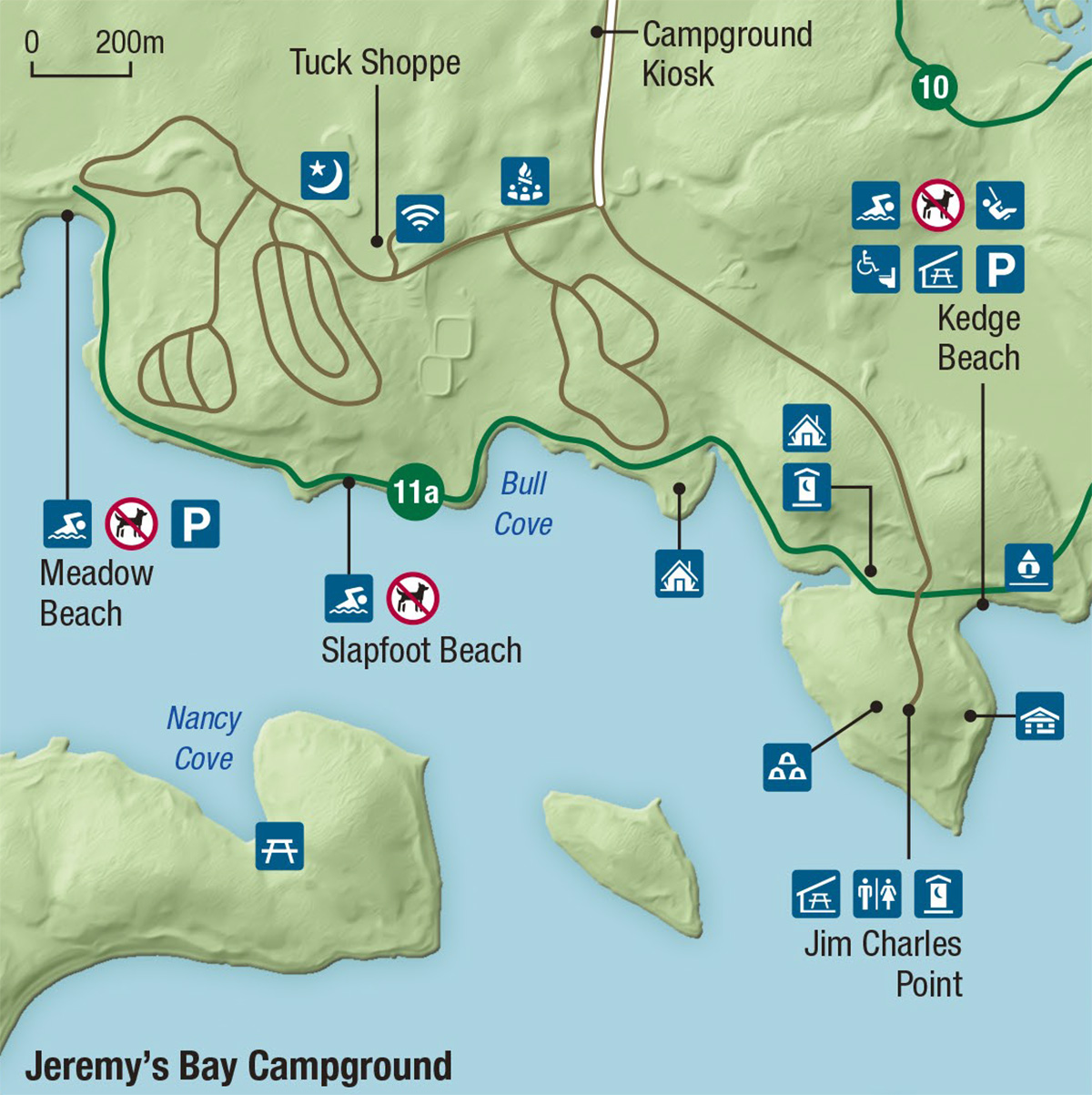
Campground kiosk
Tuck Shoppe
![]() Sky Circle
Sky Circle
![]() Wi-Fi
Wi-Fi
Campfire Circle
Jim Charles Point
![]() Picnic Shelter
Picnic Shelter
![]() Gender-specific washrooms
Gender-specific washrooms
![]() Outhouse
Outhouse
![]() Group Camping
Group Camping
![]() Rustic Cabin
Rustic Cabin
![]() oTENTik
oTENTik
![]() Ôasis
Ôasis
Nancy Cove
![]() Picnic
Picnic
Meadow Beach
![]() Swimming
Swimming
![]() No Dogs Allowed
No Dogs Allowed
![]() Parking
Parking
Slapfoot Beach
![]() Swimming
Swimming
![]() No Dogs Allowed
No Dogs Allowed
Kedge Beach
![]() Barrier-free access
Barrier-free access
![]() Swimming
Swimming
![]() No Dogs Allowed
No Dogs Allowed
![]() Playground
Playground
![]() Washrooms
Washrooms
![]() Picnic Shelter
Picnic Shelter
![]() Parking
Parking
Jake's Landing services and facilities
![]() Canoe rental
Canoe rental
![]() Kayak rental
Kayak rental
![]() Bike rental
Bike rental
![]() Gender-specific washrooms
Gender-specific washrooms
![]() Picnic Area
Picnic Area
![]() Sorting station
Sorting station
![]() Parking
Parking
Merrymakedge services and facilities
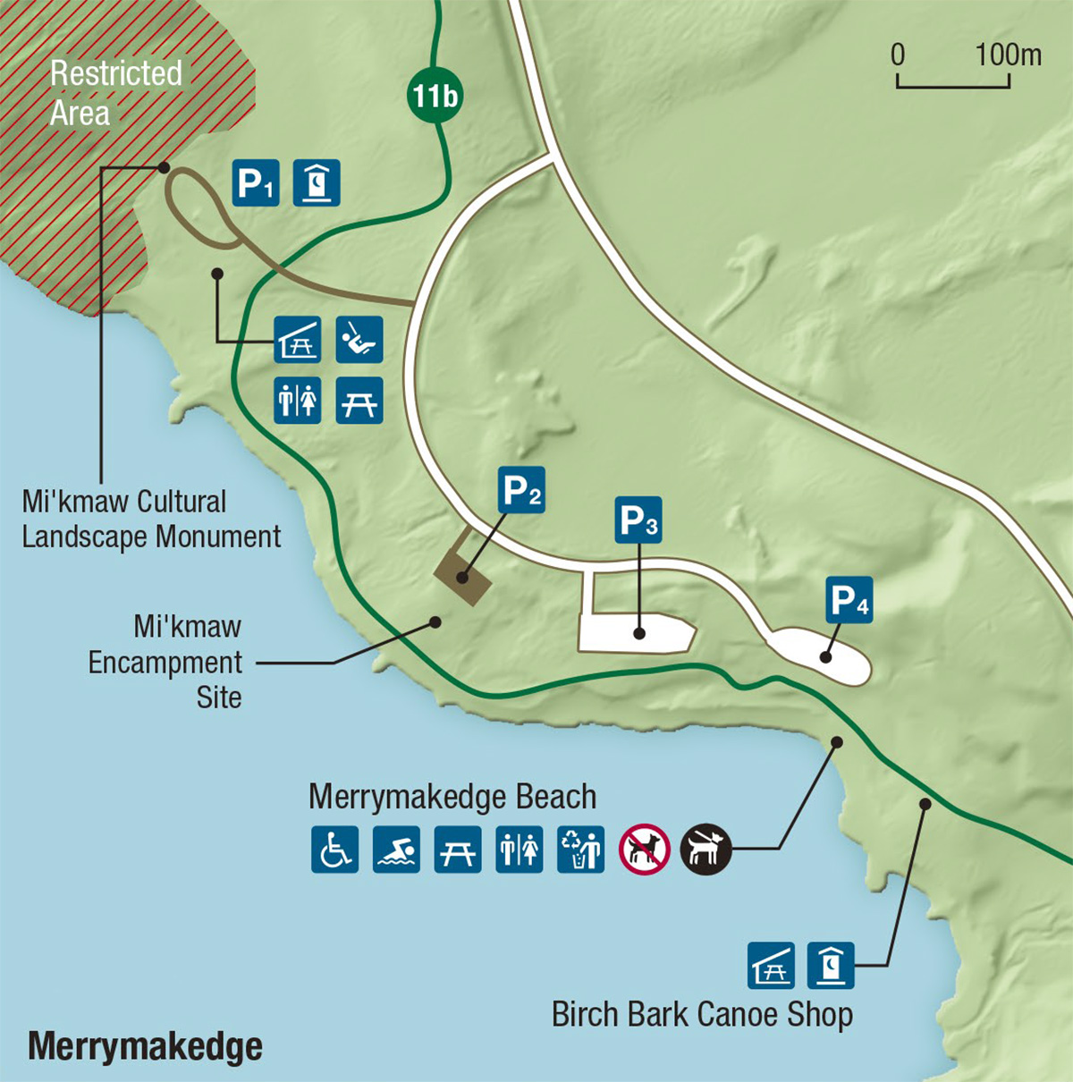
 Restricted area
Mi'kmaw Cultural Landscape Monument
![]() Parking
Parking
![]() Outhouse
Outhouse
![]() Gender-specific washrooms
Gender-specific washrooms
![]() Picnic Shelter
Picnic Shelter
![]() Playground
Playground
![]() Picnic Area
Picnic Area
Mi'kmaw Encampment Site
![]() Parking
Parking
Birch Bark Canoe Shop
![]() Picnic Shelter
Picnic Shelter
![]() Outhouse
Outhouse
Merrymakedge Beach
![]() Parking
Parking
![]() Gender-specific washrooms
Gender-specific washrooms
![]() Picnic Shelter
Picnic Shelter
![]() Playground
Playground
![]() Picnic Area
Picnic Area
![]() Barrier-free Access
Barrier-free Access
![]() Wi-Fi
Wi-Fi
![]() Sorting Station
Sorting Station
 New Lakeview Café & Eatery
![]() Swimming
Swimming
![]() No Dogs Allowed
No Dogs Allowed
![]() On-leash Dogs Allowed (Merrymakedge Beach)
On-leash Dogs Allowed (Merrymakedge Beach)
Grafton
![]() Sorting station
Sorting station
![]() Parking
Parking
Eel Weir
![]() Parking
Parking
![]() Outhouse
Outhouse
Area shown on the map
- Date modified :