
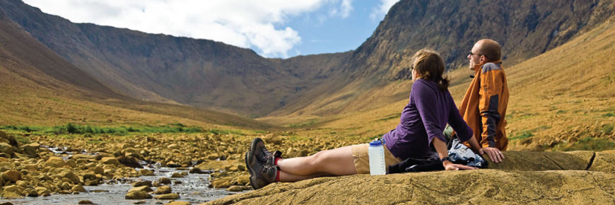
A Picnic with a View
Gros Morne National Park
“Take-out” takes on a whole new meaning!
Everything tastes better when you eat it outside.
Landscapes that were millions of years in the making, lighthouses, waves lapping the shore, sunsets over the ocean – a picnic doesn’t get much better than this! Choose your spot from our “insider’s list” and enjoy a picnic with a view.
It's as easy as 1, 2, 3!
- Grab your blanket, some binoculars and your camera … and don’t forget your reusable fork, knife and spoon!
- Pack a lunch or place an order at a local restaurant
- Choose your spot from our “insider’s list” of the best picnic locations at Gros Morne National Park, and bon appétit!
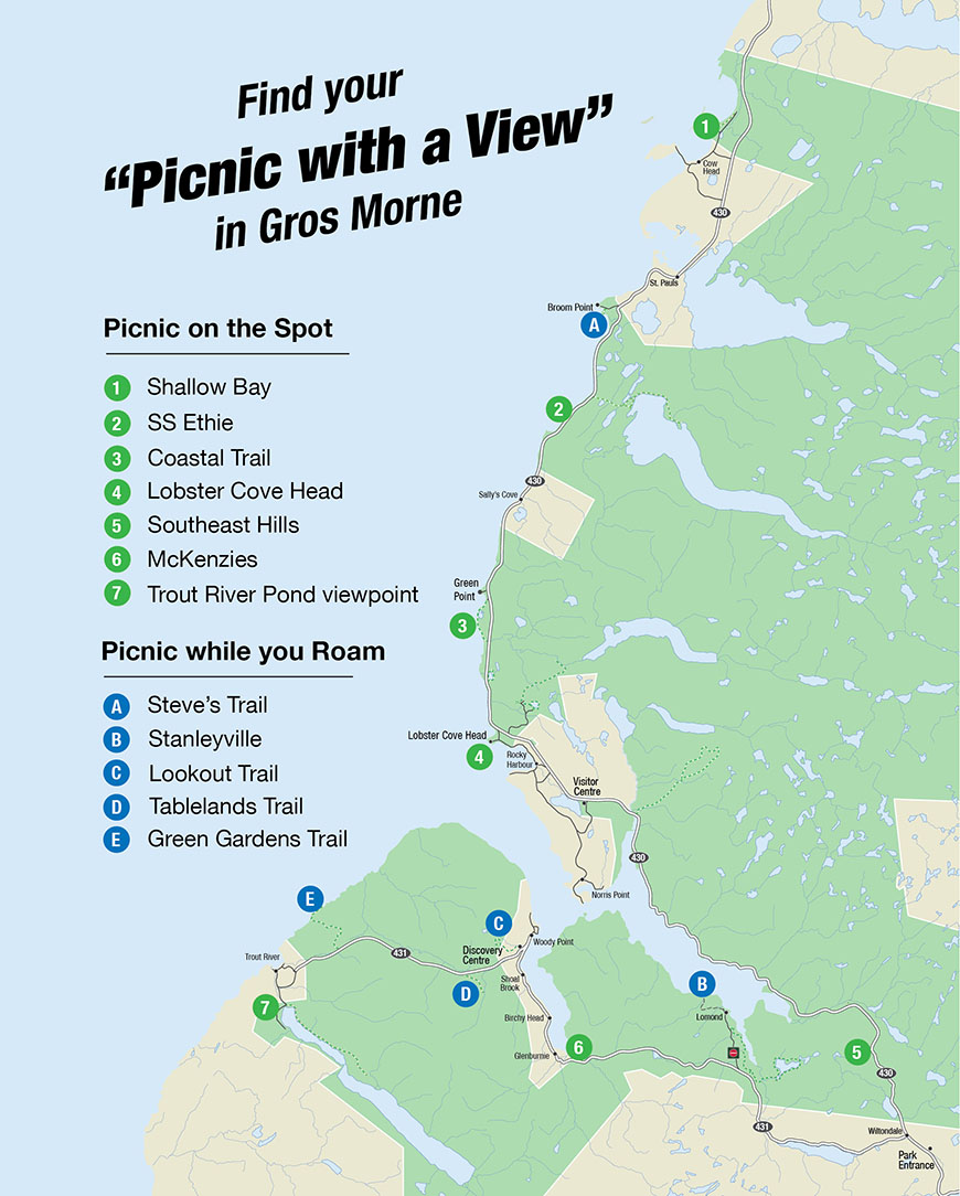
Picnic on the Spot
The following sites are easily accessible. You only need to park your vehicle and walk a short distance to find your picnic site with a view.
Shallow Bay – a beach picnic
Shallow Bay – a beach picnic

Kilometres of white sand stretch along the coast giving you lots of space to find the perfect spot. Spread out your picnic, and enjoy the view of bay and dunes. Don’t forget swimsuits and towels, buckets and shovels. This picnic spot is perfect for building sandcastles, wading and swimming, or just relaxing on the beach.
How to get there: From Route 430 turn into the town of Cow Head. Follow signs north towards Shallow Bay picnic area where you will find parking, washrooms, and changerooms. Follow the path down to the sandy beach.
Coordinates 49’56’2”N 57’46’30”W
SS Ethie Site – a picnic with history
SS Ethie Site – a picnic with history

On the northern coastal lowlands of Gros Morne you will find a wind-swept land of stunted forests and low cliffs. Pause to take it in by pulling off at Martin’s Point to learn the story of the SS Ethie. Near the parking lot are red chairs where you can take in the sweeping view. Descend the wooden stairs to find a historic scene where the rusty remains of the SS Ethie lay scattered on the beach. A raging winter storm drove this steamship to shore in December 1919. Over a hundred years later, this story lives on in local folklore. Picnic on the cobbled beach to hear the wind whisper its tale while you contemplate the movement of history and waves, the passage of time and birds, or simply enjoy a perfect sunset.
How to get there: From Route 430 turn into the SS Ethie Site, about 3 km North of Sally’s Cove .
Coordinates 49.7724 N -57.8993W
Coastal Trail – picnic day or night
Coastal Trail – picnic day or night

You can enjoy this view of the coast any time of day, but remember, in NL not all lunches are eaten at midday. Come back after dark and dine under the stars. This picnic spot, opening to the southern horizon, just happens to be one of the best stargazing locations in the Park. When you grab your picnic basket and a thermos of hot tea, don’t forget to set your headlamp to red light!
How to get there: Follow route 430 14 km north of Rocky Harbour. Access the Coastal Trail from the parking lot at Bakers Brook. Follow the trail until you find your favourite spot along the coast. Headlamps or flashlights are a must after dark.
Coordinates 49’65’63” N -57’95’57”W
Lobster Cove Head – stunning views and fairy caves
Lobster Cove Head – stunning views and fairy caves

Grassy fields invite an idyllic picnic near Lobster Cove Head’s historic lighthouse. If the wind doesn’t blow you away, the view certainly will! This is the perfect place to enjoy the sunset (and maybe see some whales). And if the wind IS blowing? Follow the trails through tuckamore forests and find a fairy cave to picnic in (fair warning, fairy ceilings are low and parents may have to picnic outside).
How to get there: From Route 430 take the Lobster Cove Head turn at the north end of Rocky Harbour, and turn into the LCH parking lot. Walk the short path towards the lighthouse. Washrooms are available near the parking lot.
Coordinates 49.6031 N -57.9536 W
Southeast Hills – the Park at your feet
Southeast Hills – the Park at your feet

Picnic just off the highest stretch of road on the island of Newfoundland. From this hilltop picnic area you can look west into the forested Lomond River Valley or look east to the barren alpine mountain tops of the Long Range. Avail of the kitchen shelters and washrooms on site, use the picnic tables or sprawl out in the grass. At night this is a great stargazing location, easily accessible and away from artificial lights.
How to get there: From the Park entrance at Wiltondale travel 5 km north on route 430 . From the Visitor’s Centre travel 30 km south on route 430.
Coordinates 49.4396 N -57.6394W
McKenzies – a traditional local picnic
McKenzies – a traditional local picnic

Relax at McKenzies, a favourite local picnic spot for generations. Use the drive in picnic hollows, walk out through the trees to the shallows of Bonne Bay, or follow a short path towards the shelter surrounded by flat grassy fields, and a babbling brook. Enjoy time with friends and family, throw a ball or a frisbee, and observe birds or squirrels, often as friendly as Bonne Bay’s human residents (thank you for not feeding the friendly wildlife).
How to get there: Turn into McKenzies directly from Route 431, 24km west of Wiltondale, or 1 km east of Glenburnie.
Coordinates 49.4334 N -57.8757 W
Trout River Pond Viewpoint – your tailgate picnic
Trout River Pond Viewpoint – your tailgate picnic

You don’t even need to get out of your vehicle to enjoy this well placed picnic venue. This tiny scenic lookoff offers a huge drive-in view down Trout River Pond. Your soul can only be uplifted by this stunning view, where the orange Tablelands are contrasted by the gray cliffs of the North Arm Mountains. Step out to one of the picnic tables, dine on your dashboard, or back in to have a tailgate picnic.
How to get there: Drive to the end of the 431, at this T-junction in the town of Trout River turn left. Follow the signs for Trout River Campground (road will change from pavement to gravel). A sign with a viewpoint icon will indicate the turn off to your right to access the viewpoint.
Coordinates 49.4596 N -58.1243W
Picnic while you Roam
The following sites require a little more effort. Having parked your vehicle, you can now walk a distance to reach your picnic site. Distances for each site are mentioned in its description.
Steve’s Trail – sand dunes and panoramic view
Steve’s Trail – sand dunes and panoramic view

Wander down Steve’s Trail (900m return) until the woods open to reveal a seaside meadow with panoramic views of the coastline and the Long Range Mountains. A set of red chairs sits in the centre of your perfect picnic area, a great vantage point for watching seabirds dive or clouds float by. Walk the stairway down to the river’s edge to sit amongst boulders or to walk in the sand.
How to get there: Steve’s Trail starts from the parking lot at Broom Point.
Coordinates 49.8356 N -57.8628 W
Stanleyville – travel by water to your private picnic
Stanleyville – travel by water to your private picnic

By kayak or by boat, travel (2 km) along the East Arm of Bonne Bay to arrive at this quiet cove, formerly the site of a logging town. Lay out your picnic blanket, enjoy the breeze from the bay and the calming sounds of leaves rustling through the trees. Explore the cove and you might find evidence of old machinery and gardens, or you might discover that you’ve stumbled upon one of Gros Morne’s greatest rock skipping beaches.
How to get there: by boat or kayak. Backcountry campsites available, contact 709-458-2417 for details.
Coordinates 49.4668 N -57.7768 W
Lookout Trail – a panoramic picnic
Lookout Trail – a panoramic picnic

Earn your lunch by setting out from the Discovery Centre parking lot to climb the Lookout Trail (5km return). You’ll pass through forest before breaking out above the treeline on top of Lookout Hills. This alpine plateau covered in low brush and berry bushes makes a perfect mid-hike picnic spot. A platform with iconic red chairs provides the perfect pre-picnic selfie. Then lay your picnic blanket on the cushion of low growth and stretch out to enjoy one of the best views in the Park.
How to get there: Trailhead starts from the Discovery Centre parking lot on Route 431 near the community of Woody Point.
Coordinates 49.4926 N -57.9278W
Tablelands – a picnic of discoveries big and small
Tablelands – a picnic of discoveries big and small

A contrast of boreal forest ending abruptly in a seemingly barren moonscape of rusty coloured rock. Take in the striking landscape of this mammoth geological oddity - a piece of the Earth’s inside. Wander a little off trail. Find a spot all your own. Settle in. Then, shift your focus from the macro to the micro, because this place is a picnic of tiny, unexpected wonders. Warning: risk of heightened wonder; you are picnicking on the Earth’s mantle, uplifted when continents collided half a billion years ago.
How to get there: Tablelands trail is on Route 431, 4kms west of the Discovery Centre.
Coordinates 49’47’84” N -57’97’43”W
Green Gardens – sheep and sea stacks
Green Gardens – sheep and sea stacks

Sea stacks and volcanic coastline are the reward of this 4.5km hike from the trailhead to the ocean (9km return). Pillow basalts from an ancient ocean floor are the foundation of this coastline. Rich volcanic soil provides nutrients for the lush meadows that give this place its name. Generations of Trout River residents have grazed their sheep here, and still do. At Green Gardens, Earth and Time have created a lovely space for sheep to graze and humans to picnic. Make it an overnight option, call 709-458-2417 to ask about backcountry campsites.
Warning: be wary of cliffs and sheep, both are best observed from a distance.How to get there: The trail starts from the parking lot for Green Gardens - Long Pond, 5 km east of Trout River and 15 km west of the Discovery Centre.
Coordinates 49.4905 N -58.0773W
- Date modified :