
Strategic Environmental Assessment of Jasper National Park Management Plan
Jasper National Park
Approval
Approved on April 14, 2022 by:
Alan Fehr
Field Unit Superintendent
Jasper Field Unit
Table of Contents
- 1 Summary
- 2 Introduction
- 3 Methods
- 4 Expected changes for next 10 years
- 5 Public, Indigenous and stakeholder engagement
- 6 Cumulative effects and strategic mitigations
- 6.1 Glaciers
- 6.2 Hydrology
- 6.3 Water quality
- 6.4 Aquatic communities
- 6.5 Wetlands
- 6.6 Forest vegetation
- 6.7 Montane habitat including grasslands, wet meadows and dunes
- 6.8 Alpine habitat
- 6.9 Whitebark pine
- 6.10 Terrestrial birds
- 6.11 Carnivores
- 6.12 Woodland caribou – southern mountain population
- 6.13 Mountain goats
- 7 Outstanding Universal Value
- 8 Federal Sustainable Development Strategy
- 9 Conclusions
- 10 References
- 11 Appendix A
1 Summary
All national park management plans are assessed through a strategic environmental assessment to understand the potential for cumulative effects. This understanding contributes to evidence-based decision-making that supports ecological integrity being maintained or restored over the life of the plan. The strategic environmental assessment for the management plan for Jasper National Park (the Park) considered the potential impacts of climate change, local and regional activities around the park, expected increases in visitation, and proposals within the management plan.
The strategic environmental assessment assessed the potential impacts on different valued components of the ecosystem, including aquatic communities, forest vegetation, montane and alpine habitat, whitebark pine, terrestrial birds, carnivores, woodland caribou and mountain goats.
The management plan identifies objectives and targets including developing responses to climate change impacts, instituting visitor use management tools to protect the Park's ecological resources, and allowing ecological processes to shape native vegetation communities to address cumulative effects of climate change, visitation, invasive species and diseases, and impacts to regional connectivity.
Glaciers, forest vegetation, montane grasslands and dunes, and woodland caribou are rated as poor in the 2018 State of the Park Report, and are likely to be further impacted by climate change, invasive species and disease, and regional activities outside the Park. The management plan identifies objectives and targets to address these potential effects.
The strategic environmental assessment identified expected impacts on the following valued ecosystem components:
Glaciers — Climate change is the primary stressor impacting glaciers. Parks Canada is taking action to minimize the contributions of park operations to greenhouse gases and seeking to understand the impacts of climate change and share this knowledge with visitors and Canadians. The implementation of the management plan is not expected to contribute additional negative cumulative effects on glaciers.
Hydrology — Climate change will impact hydrology over the next 10 years. The implementation of the management plan will address the main threats to water connectivity and is not expected to contribute additional negative effects on water flows.
Water quality — Climate change could contribute to cumulative effects on water quality. The management plan indicates that wastewater in the Park must meet Parks Canada standards and/or applicable provincial standards. The implementation of the management plan is expected to maintain water quality in the Park.
Aquatic communities — The management plan provides direction on managing aquatic communities by preventing the establishment of new invasive species and diseases, and by controlling and eliminating existing invasive species. The implementation of the management plan is expected to improve aquatic communities in Jasper National Park.
Wetlands — Climate change and invasive species are the main sources of cumulative effects on wetlands. The management plan provides direction on reducing knowledge gaps and protecting sensitive habitats. The implementation of the management plan is expected to maintain the condition of wetlands in Jasper National Park.
Forest vegetation — The main sources of cumulative effects on forests are fire suppression, insect and disease, and climate change. The management plan includes targets to complete a vegetation resource inventory, to use fire strategically to protect key habitat, and to conduct regular invasive and alien plant species monitoring. This will improve the understanding of the extent of landscape-level changes from the mountain pine beetle infestation and facilitate evidence-based management decisions, improve forest vegetation, and allow for prioritization of efforts to achieve ecological integrity goals, respectively.
Montane grasslands and dunes could be further impacted by climate change and by maintenance and operations of existing highway and utility infrastructure. The management plan includes a suite of targets to limit new disturbance in the montane, including inventories, monitoring, finalizing the Jasper National Park Vegetation Management Strategy, and identifying restoration targets for priority habitats. Improved vegetation mapping will help ensure impacts on montane habitats are minimized during project-level impact assessments. The management plan directions are expected to maintain montane grassland and dunes in the Park.
Alpine habitat — Climate change and visitation are the primary cumulative effects impacting alpine habitats. The management plan aims to promote visitor stewardship behaviour and is not expected to contribute additional negative cumulative effects on alpine habitats.
Whitebark pine — The main sources of cumulative effects on whitebark pine include white pine blister rust, climate change and wildfires. The implementation of the management plan, the recovery strategy and Jasper's multi-species action plan will collectively address the main threats to whitebark pine inside the Park and provide the best efforts for recovery.
Terrestrial birds — Climate change is the primary stressor for terrestrial birds. Updating and implementing the multi-species action plan will improve resilience for bird species that are particularly susceptible to climate change. The implementation of the management plan is expected to support the landscape conditions needed to maintain the status of terrestrial birds in the Park.
Human-wildlife conflict — High levels of road and rail traffic, a variety of natural and artificial attractants, and increasing visitation have the potential to contribute to cumulative effects on carnivore mortality and human-wildlife conflict. The management plan provides direction to proactively and reactively manage these sources of wildlife stress and mortality, and aims to restore more natural wildlife behaviours and distributions.
Connectivity — The main sources of cumulative effects on carnivore connectivity are the existing roads, highways and rail line, visitation, trails and infrastructure. Management plan objectives include increasing habitat connectivity within and across the Park's boundaries where land use pressures and climate change may impact transboundary wildlife populations and natural processes.
Carnivore habitat — Increases in visitation and climate change will impact carnivore habitat security. The management plan provides direction for visitor use management that will ensure habitat security is maintained.
Woodland caribou — Two of the remaining three herds in the Park are facing extirpation. Regional activities, activities within the Park, predation and climate change all contribute to cumulative effects experienced by caribou. Following the direction provided by the Recovery Strategy for the Woodland Caribou, Southern Mountain population (Rangifer tarandus caribou) in Canada (Environment Canada 2014), the management plan includes a number of actions to address these effects. Parks Canada will make a decision about pursuing conservation breeding and herd augmentation. The management plan is not expected to cause important negative effects to caribou.
Mountain goats — The management plan is not expected to cause additional negative cumulative effects on mountain goats, which generally use well-defined ranges. Mitigation measures for mountain goats are best addressed through park operations and project-level impact assessments for future initiatives.
Jasper National Park is part of the Canadian Rocky Mountain Parks World Heritage Site. The world heritage values for which it was designated were evaluated to ensure the management plan adequately protects them.
The management plan will result in many positive impacts on the environment, including maintaining or restoring natural wildlife distribution, abundance, and behaviour; ensuring visitor experience protects the Park's ecological resources; and preventing the establishment of invasive species and diseases.
Indigenous partners, stakeholders and the public were consulted on the draft management plan and summary of the draft strategic environmental assessment. Feedback was considered and incorporated into the strategic environmental assessment and management plan as appropriate.
The strategic environmental assessment was conducted in accordance with The Cabinet Directive on the Environmental Assessment of Policy, Plan and Program Proposals (2010) and facilitated an evaluation of how the management plan contributed to the Federal Sustainable Development Strategy. Individual projects undertaken to implement management plan objectives at the site will be evaluated to determine if an impact assessment is required under the Impact Assessment Act. The management plan supports the Federal Sustainable Development Strategy goals of Greening Government, Sustainably Managed Lands and Forests, Healthy Wildlife Populations, Connecting Canadians with Nature, and Safe and Healthy Communities.
Many positive environmental effects are expected, and there are no important negative environmental effects anticipated from implementation of the Jasper National Park Management Plan.
2 Introduction
In accordance with The Cabinet Directive on the Environmental Assessment of Policy, Plan and Program Proposals (2010), a strategic environmental assessment is conducted on all national park management plans. The purpose of strategic environmental assessment is to incorporate environmental considerations into the development of public policies, plans and program proposals to support environmentally sound decision-making. Individual projects undertaken to implement management plan objectives will be further evaluated to determine if an impact assessment is required under the Impact Assessment Act , and impact assessments will be conducted as appropriate.
2.1 Management plan
Future-oriented, strategic management of each national park, national marine conservation area, heritage canal, and those national historic sites administered by Parks Canada supports the Agency's vision:
"Canada's treasured natural and historic places will be a living legacy, connecting hearts and minds to a stronger, deeper understanding of the very essence of Canada."
The 2022 Jasper National Park Management Plan (the management plan), once approved by the Minister responsible for Parks Canada and tabled in Parliament, ensures Parks Canada's accountability to Canadians by outlining how the Park's management team will achieve measurable results in support of the Agency's mandate. The management plan replaces the 2010 management plan for Jasper National Park (Jasper, the Park). Parks Canada consulted with Indigenous partners, the public and stakeholder groups on the development of the new management plan.
The management plan sets clear, strategic direction for the management and operation of Jasper National Park over the next 10 years by articulating a vision, key strategies and objectives. The management plan builds on previous commitments and management plan objectives, furthering achievements from the past 10 years, and capitalizes on new opportunities in response to Agency priorities and standards.
2.2 Cumulative effects
Cumulative effects occur when multiple human activities and natural processes impact the same aspect of the environment. Cumulative effects within a national park may arise from infrastructure and activities within the Park, pressures associated with visitation, climate change, and from sources outside of the Park. Cumulative effects are best assessed and managed at a broader landscape scale rather than when each decision is made about an activity. Parks Canada assesses cumulative effects when preparing national park management plans to identify strategic mitigations for potential adverse cumulative effects, identify mechanisms to augment or support potential positive cumulative effects, and to include these where possible in the management plan. Throughout this document, the term 'mitigation' is used to mean avoidance or reduction of adverse effects of an action or activity.
In accordance with The Cabinet Directive on the Environmental Assessment of Policy, Plan and Program Proposals (2010), this strategic environmental assessment considered only aspects of the biophysical environment, as social and economic considerations are evaluated through other mechanisms.
This strategic environmental assessment assesses which cumulative effects are likely to occur over the next 10 years. Managing cumulative effects requires a deliberate and systematic multi-pronged approach, particularly for more complex cumulative effects. For example, landscape planning, impact assessment, and implementation of park policies and plans are some of the many tools that can be used to manage cumulative effects.
This strategic environmental assessment provides an overview of the methods used for assessment of potential cumulative effects, a summary of the key aspects that are affecting the Park, and a summary of their potential cumulative effects on valued ecosystem components. Strategic mitigations for potential adverse cumulative effects within the control of Parks Canada in Jasper National Park are identified.
3 Methods
3.1 Scoping
The complexity of a large geographic region with many ecosystems and species requires a strategic environmental assessment methodology that is systematic and ensures key cumulative effects issues receive the appropriate attention. In order to achieve this goal, it was decided to focus the analysis of this strategic environmental assessment on valued ecosystem components (VCs), and to conduct the level of analysis was identified for each VC. VCs were identified using the Park's Ecological Integrity Monitoring Program (EI monitoring program) the species at risk inventory, and by consideration of any other VCs that had the potential to be impacted by cumulative effects. Results of the EI monitoring program were reported in the Jasper State of the Park Report, 2018.
For certain species at risk that are (1) threatened by pressures that cannot be controlled within the Park or that do not exist in the site, (2) only transient, or (3) a very small part of the Canadian distribution, the Park does not take specific management actions or measures beyond protection measures contained in the Species at Risk Act (SARA). As a result, these species at risk were not included further in the analysis. The assessment of the Outstanding Universal Value of Jasper as a World Heritage Site was undertaken separately, and the methodology and summary of results for this assessment can be found in the Outstanding Universal Value section.
Analysis of the VCs focused on ensuring the management plan identified objectives within Parks Canada's ability to maintain or restore the VCs in 10 years' time. The level of analysis (short or detailed) for individual VCs was identified based on:
- The current status of the VC identified from the State of the Park Report, where applicable;
- The expected magnitude, vulnerability, and risk of impacts on the VC over the next 10 years; and
- The potential contribution of the Park to local and regional conservation or restoration goals.
| VC | Indicators | Current Status and Trend | Level of Analysis | |
|---|---|---|---|---|
| Glaciers | EIMP1 measures: Glaciers | Poor, declining (2018a) | Short | |
| Hydrology | EIMP measures: Water connectivity | Fair, increasing (2018a) | Detailed | |
| Water quality | Canadian Council of Ministers (CCME) water quality index2 | Good, declining (2018a) | Short | |
| Stream biotic health (CABIN3) | Good, trend unknown (2018a) | |||
| Aquatic communities | EIMP measures | Lake fish index | Fair, trend unknown (2018a) | Detailed |
| River fish | Good, increasing (2018a) | |||
| Stream biotic health (CABIN) | Good, trend unknown (2018a) | |||
| Species at risk status | Bull Trout | COSEWIC3: Threatened SARA: Threatened |
||
| Rainbow Trout (Athabasca population) | COSEWIC: Endangered SARA: Endangered |
|||
| Wetlands | EIMP measures: Amphibians | Good, stable (2018a) | Short | |
| Forest vegetation | EIMP measures: Area burned | Poor, stable (2018a) | Detailed | |
| Montane grasslands and dunes | EIMP measures: Area burned | Poor, stable (2018a) | Short | |
| Alpine habitat | EIMP measures | Alpine extent | New measure – status and trend not rated in 2018 (2018a) | Short |
| Area burned | Poor, stable (2018a) | |||
| Non-native species–plants | Unknown (2018a) | |||
| Whitebark pine | EIMP measures: Whitebark pine | Fair, declining (2018a) | Short– mountain national park scale | |
| Species at risk status | Conservation target on track (2018b)4 COSEWIC: Endangered SARA: Endangered |
|||
| Terrestrial birds | EIMP measures | Forest terrestrial birds | Fair, no trend (2018a) | Short |
| Alpine terrestrial birds | Fair, no trend (2018a) | |||
| Species at risk status | Bank Swallow | No conservation target established COSEWIC: Threatened SARA: Threatened |
||
| Barn Swallow | No conservation target established COSEWIC: Threatened SARA: Threatened |
|||
| Black Swift | No conservation target established COSEWIC: Endangered SARA: No Status |
|||
| Common Nighthawk | Conservation target on track (2018b) COSEWIC: Special Concern SARA: Threatened |
|||
| Olive-sided Flycatcher | Conservation target on track (2018b) COSEWIC: Special Concern SARA: Threatened |
|||
| Carnivores | EIMP measures | Regional Motorized Access Density | Fair, declining (2018a) | Detailed– mountain national park scale |
| Multi-species mammal occupancy | Good, stable (2018a) | |||
| Woodland caribou | EIMP measures | Woodland caribou, Population size/trend | Poor, declining (2018a) | Detailed |
| Elk density | Good, stable (2018a) | |||
| Species at risk status | Conservation target actions on track (2018b) COSEWIC: Non-active SARA: Threatened |
|||
| Mountain goats | Area-specific studies6 | Unknown | Detailed | |
| Elk | EIMP measures: Elk density | Good, stable (2018a) | See appendix | |
| Little brown myotis | Species at risk status | Conservation target on track (2018b) COSEWIC: Endangered SARA: Endangered |
See appendix | |
| Northern myotis | Species at risk status | Conservation target on track (2018b) COSEWIC: Endangered SARA: Endangered |
See appendix | |
| Gypsy cuckoo bumblebee | Species at risk status | No conservation target established COSEWIC: Endangered SARA: Endangered |
See appendix | |
| Haller's apple moss | Species at risk status | Conservation target on track (2018b) COSEWIC: Threatened SARA: Threatened |
See appendix | |
1 EIMP: Parks Canada's ecological integrity monitoring program.
2 Water quality is monitored through a joint program between Environment and Climate Change Canada and Parks Canada Agency.
3 CABIN: Canadian Aquatic Biomonitoring Network. Parks Canada assesses stream biotic health using protocols developed by CABIN.
4 COSEWIC: Committee on the Status of Endangered Wildlife in Canada.
5 Status of conservation targets as identified in State of the Park Report.
6 Research on the status and habitat use of mountain goats in Jasper has primarily been through private studies in the Marmot Basin and Columbia Icefield areas; see mountain goats section of this SEA for more information.
3.2 Describing expected changes for next 10 years
Changes with the potential to impact valued ecosystem components s over the next 10 years may result from climate change, activities and development around the Park, changes in visitation, and key proposals in the park management plan. Information about these potential changes was gathered using Parks Canada climate change resources, provincial land use plans and proposals, visitor trend data, and park management planning.
3.3 Effects assessment
Potential cumulative effects over the next 10 years were identified from existing documentation and analysis, and supplemental assessment where applicable, and are summarized in this strategic environmental assessment.
Mitigations for potential adverse cumulative effects need to be strategic, rather than detailed actions on the ground. In order to identify strategic mitigations for valued ecosystem components, the current approach to managing cumulative effects and any gaps was identified. Effective management of very complex cumulative effects requires a suite of complementary mechanisms or tools. In national parks, these mechanisms include:
- Vision and objectives for the ecological component;
- Land use and conservation planning specifically targeted for the ecological component;
- Research on mitigations, vulnerabilities or understanding the status of the ecological component;
- Restoration;
- Impact assessment parameters that facilitate assessment of individual projects within cumulative effects limits;
- Engagement, education and reporting to support the ecological component objectives;
- Monitoring; and
- Regulation and enforcement.
While simple cumulative effects situations may not require such a comprehensive approach, more complicated situations will likely need more of the tools listed above. Based on the analysis of current management tools and gaps, opportunities for improved management of cumulative effects were identified and included in the management plan or as mitigations in the strategic environmental assessment.
3.4 Key proposals in the management plan
The management plan includes key strategies, objectives and targets to guide Parks Canada's decision-making in the management of Jasper National Park over the next 10 years. The work necessary to achieve some of these objectives and targets has the potential for adverse or positive environmental impacts. These objectives and targets formed the focus of the strategic environmental assessment, and include:
- Park infrastructure is maintained and renewed to minimise risks and to ensure visitor asset infrastructure supports core visitor experiences and operational needs;
- Roadways, including the Icefields Parkway, Maligne Road, Pyramid Road, Miette Road and Cavell Road, are operated and maintained as scenic heritage corridors. Management of these corridors prioritizes visitor experience, visitor safety, and active transportation such as cycling;
- Visitor use management strategies and tools are developed and implemented to manage visitor congestion, demand, and behavioural and safety issues, to support visitors having quality experiences in a protected heritage area. These tools may include reservation requirements, visitation quotas, permits, education and awareness initiatives, transportation alternatives and parking management, among others;
- Existing campground inventories are examined against user demand. Consideration is given to adding new sites to existing campgrounds by increasing the density of individual campsites or by expanding the footprint of the campground as a whole, subject to alignment with environmental, experiential, and visitor use objectives;
- A vegetation management plan is developed and implemented for frontcountry campgrounds to address natural hazards, invasive species, wildlife attractants, trail rehabilitation and restoration of the forest.
- Changes to designated road-accessible commercial accommodations outside the community of Jasper are guided by the Redevelopment Guidelines for Outlying Commercial Accommodations and Hostels in the Rocky Mountain National Parks (2007). No land will be released for new road-accessible commercial accommodation outside the townsite boundary. Parks Canada may consider adjustments to boundaries of existing licences of occupation ancillary to existing commercial accommodations outside of the Jasper townsite, or the issuance of a new or replacement ancillary licence of occupation to one of these properties, for the purpose of environmental gains, such as facilitating green energy or improving wastewater treatment;
- Minor modifications or expansion of existing alpine huts to improve visitor experience and learning opportunities will be considered, subject to alignment with ecological objectives;
- Parks Canada may choose to solicit a third party to convert and operate one or more patrol cabins for public access, on a not-for-profit basis;
- Parks Canada may choose to solicit a third party to convert and operate a road-accessible out-of-service warden station as a public access hostel, on a not-for-profit basis;
- Parks Canada may consider a proposal from the Jasper SkyTram to redevelop aging infrastructure within the current alignment, or subject to conditions, an alternative alignment involving a leasehold reconfiguration and related adjustments to zoning and declared wilderness area boundaries. A proposed alternative alignment will only be considered if it maintains public safety, achieves environmental gains and includes only activities and services that support the core visitor activity of operating a sight-seeing passenger ropeway to and from an alpine area. Any proposed Jasper SkyTram redevelopment will be subject to decision-making through Parks Canada's impact assessment and development review processes, with Indigenous and public consultation;
- Conservation practices based on Indigenous knowledge are considered in wildlife management. Opportunities for First Nation and Métis partners to sustainably harvest fauna are facilitated in a manner that is aligned with the maintenance and improvement of ecological integrity;
- Investigate and employ technologies and systems that improve building design and construction, energy and water conservation, solid waste and wastewater management, and fleet management;
- The establishment of new invasive species and diseases is prevented or minimized and existing invasive species and diseases are controlled where feasible to protect the park's biodiversity;
- Maintain or restore aquatic ecosystems for factors such as native species, water quality, water levels, connectivity, temperature and flow regimes;
- Visitors act as park stewards and meaningfully connect to the natural and cultural values the Park is protecting through a range of learning opportunities;
- Collaborate with a variety of organizations on lands adjacent to park boundaries to address shared goals for conservation, connectivity, tourism, and cumulative effects management in the regional ecosystem; and
- The Whistlers Hostel facilities are decommissioned and the area is restored.
In addition to the proposals specifically mentioned in the management plan, Parks Canada will continue to maintain, repair, rehabilitate and improve where necessary other infrastructure and services. This will include infrastructure for visitors and infrastructure for operations, including maintaining the highway, parkway and other park roads. Parks Canada will conduct safety and environmental improvements to Highway 16 that take into account its dual role as the main access route to the Park and a national transportation route. The Icefields Parkway (Highway 93), Maligne Road, Pyramid Road, Miette Road and Cavell Road will continue to be managed as leisurely, scenic, heritage drives, rather than highways, that emphasize visitor experience and safety. Ongoing roadway asset maintenance and renewal activities include:
- Paving;
- Scaling of roadside cliffs;
- Upgrading bridges;
- Adding passing lanes;
- Improving merging/exit lanes;
- Improving drainage ditches;
- Creating a shoulder;
- Stabilizing riverbanks, including retaining walls or rip-rap;
- Replacing culverts; and
- Extracting gravel from existing pits.
All of these proposals are being considered as management plan activities assessed in the strategic environmental assessment.
In addition to the above, targets in the management plan, which, once implemented, are likely to benefit the ecological integrity of the Park, are outlined further in the mitigation section of this strategic environmental assessment.
3.4.1 Zoning changes
The zoning changes that will be made via approval of the new Jasper National Park Management Plan are minor, ensure consistency in how zoning is applied throughout the Park and resolve minor geospatial inaccuracies in previous mapping layers. The overall percentage of the Park occupied by each zone has not changed (Table 2). There are not anticipated to be any ecological impacts as a result of these zoning changes and these changes are not the focus of the assessment in the strategic environmental assessment.
Zoning amendments from the 2010 management plan are as follows:
- The boundaries of the old Ancient Forest Zone I area were expanded to more accurately reflect several scientifically-important study sites and locations of very old trees in the Columbia Icefield area;
- The upper branch of the Pyramid Mountain Access Road were rezoned from Zone III to Zone II to reflect the removal of a microwave tower and rehabilitation of the access corridor;
- Pyramid Lake was rezoned from Zone IV to Zone III, similar to other road-accessible lakes in the Park;
- Beauty Creek and Ranger Creek North gravel pits were rezoned from Zone IV to Zone II as they are no longer used operationally;
- Mile 9 gravel pit was rezoned from Zone III to Zone IV to better reflect its current operational use for gravel extraction and planned expansion within the next 10 years;
- The zoning was adjusted for part of Marmot gravel pit from Zone III to Zone IV to reflect the current extent of the pit and provide flexibility for future expansion, if required;
- The Snow Dump site north of Whistlers Campground was rezoned from Zone III to Zone IV to better reflect its use as a snow disposal area by the Municipality of Jasper;
- The lower portion of Bald Hills Fire Road was rezoned from Zone IV to Zone III. The fire road is not a public road and is used primarily as a public hiking trail, although it receives periodic motorized use to maintain water supply infrastructure operated by the commercial lessee at Maligne Lake;
- The zoning at Marmot Basin Ski Area was updated to reflect regulatory amendments to Schedule 5 of the Canada National Parks Act in 2013 and Schedule 1 of the National Parks of Canada Wilderness Area Declaration Regulations in 2017;
- The Astoria powerhouse was rezoned from Zone III to Zone IV to reflect the nature and extent of its facilities and workspaces;
- The boundaries of the Zone III area that encompasses the snowcoach road on the Athabasca Glacier were adjusted to better reflect the current location of the road and potential for future road alignment changes; and
- The zoning was adjusted along a section of easement corridor in the Celestine Road and Jasper Lake area to allow for a 25 m buffer of Zone III in accordance with declared wilderness area provisions for utility corridors.
| Zone | Area in 2010 (km2) | Area in 2020 (km2) | Change from 2010 (km2) | Percent Change | % of Park Area 2010 | % of Park Area 2020 |
|---|---|---|---|---|---|---|
| Zone 1 | 47 | 47 | 0 | 0% | 0.42% | 0.42% |
| Zone 2 | 10,923 | 10,926 | 3 | 0. 03% | 97. 27% | 97.30% |
| Zone 3 | 141 | 141 | 1 | 0% | 1.25% | 1.25% |
| Zone 4 | 116 | 113 | -3 | -0. 03% | 1.03% | 1.01% |
| Zone 5 | 2 | 2 | 0 | 0 | 0.02% | 0.02% |
| TOTAL | 11229 | 11229 |
3.5 Non-Parks Canada activities in the park
The numerous facilities and infrastructure in Jasper reflect an earlier approach to conservation and recreation in the mountain national parks. Jasper National Park contains a townsite, the Municipality of Jasper.
There are legislated limits on growth and development in the Community of Jasper, as outlined in the Canada National Parks Act. The population of the town increased by 3.6% from 2011 to 2016 (Statistics Canada 2019). The Municipality of Jasper anticipates that growth rates over the next 10 years will range between 0.1% and 0.3%, and the population in 2040 is expected to be between 4,900 and 5,225 (Municipality of Jasper and Parks Canada 2011). These numbers do not include transitory or seasonal workers. In response to this growth, new housing units will be required. Limits on development in the Community of Jasper, including limits to commercial development, a townsite boundary, and eligible residency requirements are outlined in the Canada National Parks Act and the National Parks of Canada Lease and Licence of Occupation Regulations. The community boundary contains approximately 245 ha, and commercial development in the community is capped at 118,222 m2, as described in the Canada National Parks Act.
Marmot Basin is a commercial ski hill located in Jasper, approximately 10 km south of the Municipality of Jasper. The Marmot Basin Ski Area Site Guidelines for Development and Use (2008) identifies limits to growth and capacity. Commercial area is capped at 6,270 m2, and the capacity is limited to 6,500 skiers per day (Parks Canada 2008). The ski hill is limited to winter use only.
The Jasper SkyTram, located just north of the ski hill lease boundary on the side of the Whistlers Mountain, is a sight-seeing tourist attraction that takes visitors from the valley bottom into the alpine via an aerial passenger tramway. It operates from March to October and can carry about 200 passengers an hour. Jasper SkyTram has conceptual plans to redevelop and potentially re-route their aging infrastructure.
Banff Jasper Collection by Pursuit (formerly Brewster) operates numerous hotels and attractions in the Park, including the Columbia Icefield Glacier Discovery Centre, the Columbia Icefield SkyWalk, Columbia Icefield Adventure Athabasca Glacier tours, Maligne Lake boat tours, and day-use lodges incorporating restaurants and retail at Maligne Canyon and Maligne Lake.
There are 12 road-accessible hotels outside the townsite, with the Fairmont Jasper Park Lodge hotel and golf course the largest of these. There are four hostels outside the townsite, six alpine huts and cabins, and three backcountry lodges.
Parks Canada issues guided business licences for activities including fishing, hiking, rafting, and horse tours in the Park. In 2019, there were more than 40 guided business licence holders operating in the Park. New guided business licence requests are reviewed against Parks Canada regulations and policy, and assessed for environmental impacts. The Association of Canadian Mountain Guides (ACMG) is currently issued one licence for all member guides; as of 2023 each member guide will be required to obtain individual licences rather than operating under a blanket licence.
Third party transportation and utility infrastructure in Jasper includes the Trans Mountain pipeline, the Canadian National Railway (CN), the Telus fibre optic network, and ATCO's electrical transmission line and natural gas pipeline. Each of these traverses the Park following a route roughly parallel to Highway 16. Smaller electrical, natural gas and phone lines are also present in the Park. Additionally, ATCO runs a small hydroelectric generation station on the Astoria River, and the Columbia Icefield Discovery Centre and Sunwapta Falls Rocky Mountain Lodge operate independent power generators.
Potential third party development projects over the next 10 years include a Jasper SkyTram redevelopment and potential realignment, ATCO Electric distribution line recapitalization, and CN long-term flood mitigation for the Snake Indian River. Trans Mountain is expected to complete a program of maintenance digs and testing in late 2022, in conjunction with its Line 1 Reactivation program. This work includes several new valve sites and improvements to existing valves. Trans Mountain has also introduced a proposal to install a pipeline monitoring conduit, using fibre optics technology, that would involve trenching in their easement alongside the existing pipeline segments, within existing disturbances. Included in Trans Mountain's fibre optics proposal is the opportunity to install a telecommunications fibre optic line in the same conduit (with no expected additional environmental impacts). These facilities, infrastructure and potential projects will be considered as part of the cumulative effects assessment in this strategic environmental assessment.
4 Expected changes for next 10 years
4.1 Climate change
The impacts of climate change are felt across the national park system, from the ecosystems and cultural resources Parks Canada protects, to the facilities and infrastructure we build and maintain, to the visitor experiences we offer. Jasper, along with the other mountain national parks, is experiencing the impact of climate change, and these impacts are projected to increase for decades to come.
Climatic changes are expected to be most visible in Jasper through glacial retreat, change in the composition and structure of high-elevation forests, reduction in alpine meadow habitat, and changes in vegetation and wildlife species distribution, including the expansion of invasive species.
Canada's rate of warming is about double the global rate, and the last three decades have been the warmest 30-year period in at least 1,400 years. The mountain national parks have experienced a 2°C warming trend over the last century, and this trend is projected to continue (Parker 2019). Model results indicate a further increase in Jasper by up to 3°C by 2040 depending on the location within the Park (Parker 2019).
Seasonally, the greatest warming has occurred in the winter (approximately 3.9°C) with spring arriving as much as 5 to 20 days earlier (Vincent et al. 2015). Increased air temperature will affect the frost-free season throughout the Park. In the Municipality of Jasper, frost-free days are projected to increase from a mean of 92.4 days at baseline to 143.5 days by 2051–2080 (Parker 2019). Extreme heat events have increased in many areas, while extreme cold events have decreased in virtually all areas (Mekis et al. 2015). This trend is expected to continue, with an increase in the frequency, intensity and duration of heat events (IPCC 2012).
Precipitation has been variable in the mountain national parks over the past 70 years, with a general increase in total annual precipitation of 14% over that period (Parker 2017). Precipitation is expected to be variable throughout Jasper, ranging from 100 mm to more than 500 mm above baseline from 2011 to 2040 (Parker 2019). Today's "one in 100 year" rainfall event (i.e., 22-48 mm/h) is projected to become a "one in 25-50 year" event, and the future "one in 100 year" event is projected to increase by an additional 6-9 mm/h (Parker 2017). Increasing temperatures have resulted in an increase in the fraction of precipitation that falls as rain versus snow, and as a consequence, snowpack in Jasper is declining (Parker 2019).
Despite increases in total annual precipitation, increasing temperatures and drier summers are expected to increase the wildfire season by 20–60 days throughout much of the Park (Parker 2019). In addition, the maximum rate of ice volume loss, which corresponds with the peak input of glacial meltwater to streams and rivers, is projected to occur around 2020–2040 (Parker 2017), which will impact river flow over the long term. Many species are likely to be affected by climate change, including grizzly bears, caribou, birds and fish (Parker 2019).
Changes from climate change are considered throughout this strategic environmental assessment, and strategies and targets for adapting to climate change are incorporated into the 2022 Jasper National Park Management Plan.
4.2 Activities and development outside the Park
Jasper shares 66.7% of its boundary with several other protected areas, including national and provincial parks and recreation areas. The northern boundaries of Jasper are in large part bordered by Alberta provincial protected areas, including Willmore Wilderness Park and Rock Lake-Solomon Creek Wildland Provincial Park. To the southeast lies Whitehorse and Brazeau Canyon wildland provincial parks, and White Goat Wilderness Area. Jasper's southern boundary is also shared with Banff National Park, while its western border is partially shared with Mount Robson and Hamber provincial parks in British Columbia (Figure 1).
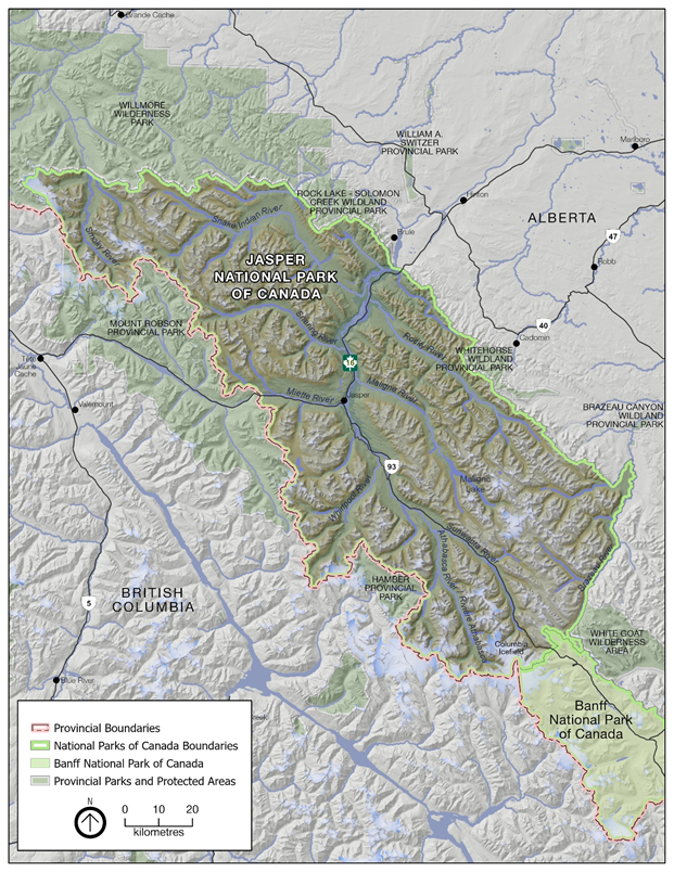
Text description
This map shows the full extent of Jasper National Park, and includes major highways, rivers and lakes. The boundary of Jasper National Park is indicated with a green line.
A pink dashed line indicates the border between British Columbia and Alberta, which runs along the western boundary of Jasper National Park, from northwest to southeast near the centre of the map.
The map shows surrounding National and Provincial protected areas. Wilmore Wilderness Park, Rock Lake-Solomon Creek Wildland Provincial Park and William A. Switzer Provincial Park are shown to the north. Whitehorse Wildland Provincial Park lies to the east. White Goat Wilderness Area and a portion of Banff National Park are shown to the south, and Hamber and Mount Robson provincial parks are shown to the west.
A north arrow pointing up, and scale bar from 0 to 20 kilometres is shown in the top right corner.
Major rivers and lakes are shown in dark grey and include the Smoky River, Snake Indian River, Snaring River, Miette River, Whirlpool River, Athabasca River, Rocky River, Maligne River, Maligne Lake, Sunwapta River and Brazeau River.
Highway 16 is shown running east-west through the central portion of the park, and 93N is shown running north-south through the southern two-thirds.
The Town of Jasper is labelled near the centre of the map. Surrounding towns outside of the park are labelled, including Brûlé, Hinton, Marlboro, Cadomin and Robb to the east within Alberta. The communities of Tête Jaune Cache, Valemount, Blue River and Mica Creek are shown to the west within British Columbia.
Recreation is increasing in some of the neighbouring parks, including increasing visitation to Berg Lake in Mount Robson Provincial Park. The Alpine Club of Canada is constructing a new hut in Mount Robson Provincial Park, less than 1 km from Jasper's boundary. In 2014, a private heli-access lodge operated by the Canadian Adventure Company was developed within 2.5 km of Jasper's western boundary, in proximity to the Tonquin Valley.
Portions of Jasper's boundary on both the eastern and western sides are unbuffered by provincial parks. Activities and development outside the Park that influence aspects of the Park's environment include industrial development activity such as forestry, coal mines, and associated roads. Forests are largely allocated for industrial use in unprotected areas on both the Alberta and British Columbia side of the Park. Forestry industry footprint expansion is anticipated within the next 10 years.
Mining is also expected to continue east of Jasper over the life of this management plan. Bighorn Mining's Coalspur Vista mine, an open-pit surface coal mine, is situated approximately 30 km beyond Jasper's eastern border. Graymont, a limestone mining company, has been granted sub-surface rights to an area in the Overlander area outside of Jasper near Hinton, although there are no immediate plans to develop the site. Oil and gas infrastructure are also in place in unprotected areas east of Jasper. As of 2020, the Teck Cardinal River Mine, situated 5km outside of the Park, has ceased operations and is entering an end-land use reclamation phase. Additional leases are undeveloped but allocated for oil and gas exploration and/or production. The number of seismic lines and other linear disturbances has been increasing over the last decade in unprotected areas around the Park (Alberta Biodiversity Monitoring Institute 2019).
Use of recreational vehicles including snowmobiles and all-terrain vehicles (ATVs) is widespread outside of the Park boundaries. Hunting, trapping, recreational fishing, and some conservation activities such as predator control will continue to be a source of impacts to transboundary wildlife. For example, the Government of Alberta is conducting annual wolf control activities to support the recovery of the À La Pêche caribou herd. Both wolves and caribou are examples of transboundary species requiring multi-jurisdictional collaboration.
These activities beyond park boundaries are considered as part of the cumulative effects assessment in this strategic environmental assessment.
4.3 Changing visitation
In 2019, Jasper hosted almost 2.5 million visitors. This is an increase of 28% since the last park management plan was written in 2010 (Figure 2). In the summer months of 2019, Jasper's visitor base was a mix of international visitors (67%) and domestic visitors (33%). Visitation rates in the Park are affected by global events, economic conditions and local weather.
The majority of people visit the Park from May to September. Jasper is largely considered to be "at capacity" in July and August due to zero vacancy in hotels and campsites during these months (Figure 3). Still, visitor use appears to continue to increase in the summertime, possibly due to an increase in day visitors from nearby Banff, Hinton and Valemount. There has been a large increase in visitation in recent years in June and September, which was previously considered "shoulder season" in Jasper.
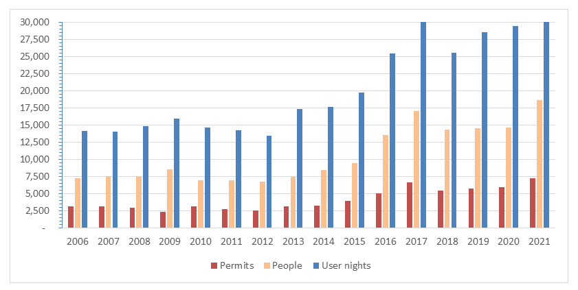
Frontcountry (road-accessible) camping continues to grow in pace with visitation, while backcountry camping has grown more significantly over the past 5 to 10 years, with user nights doubling since 2010 (Figure 4).
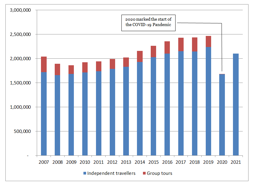
Text description
| Jasper National Park Yearly Attendance | |||||||||||||||
|---|---|---|---|---|---|---|---|---|---|---|---|---|---|---|---|
| Year | 2007 | 2008 | 2009 | 2010 | 2011 | 2012 | 2013 | 2014 | 2015 | 2016 | 2017 | 2018 | 2019 | 2020 | 2021 |
| Independent Travellers |
1,720,009 | 1,656,335 | 1,678,279 | 1,712,211 | 1,736,595 | 1,782,960 | 1,826,631 | 1,928,491 | 2,026,740 | 2,099,654 | 2,150,307 | 2,141,449 | 2,234,008 | 1,672,497 | 2,100,036 |
| Group Tours | 319,073 | 235,246 | 180,305 | 212,072 | 204,011 | 208,522 | 196,247 | 226,219 | 232,090 | 255,155 | 274,911 | 293,216 | 232,477 | 2,347 | -- |
| Total | 2,039,082 | 1,891,581 | 1,858,584 | 1,924,283 | 1,940,606 | 1,991,482 | 2,022,878 | 2,154,710 | 2,258,830 | 2,354,809 | 2,425,218 | 2,434,665 | 2,466,485 | 1,674,844 | 2,100,036 |
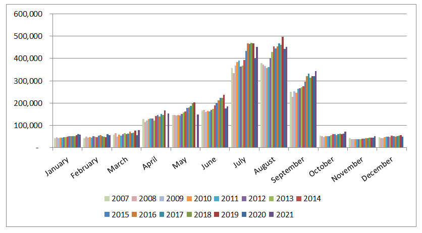
Text description
| Jasper National Park Monthly Attendance by Year (Independent Travellers) | ||||||||||||
|---|---|---|---|---|---|---|---|---|---|---|---|---|
| January | February | March | April | May | June | July | August | September | October | November | December | |
| 2007 | 43,680 | 43,650 | 59,510 | 129,130 | 146,460 | 167,390 | 356,870 | 379,150 | 249,550 | 54,270 | 42,121 | 48,199 |
| 2008 | 47,642 | 50,587 | 64,240 | 115,190 | 145,840 | 168,120 | 334,210 | 371,690 | 227,400 | 51,863 | 37,305 | 42,043 |
| 2009 | 43,145 | 44,562 | 50,419 | 122,070 | 144,680 | 161,020 | 367,230 | 364,890 | 252,170 | 46,790 | 37,835 | 43,449 |
| 2010 | 44,799 | 47,257 | 57,818 | 128,620 | 145,560 | 164,980 | 383,110 | 356,950 | 246,650 | 52,143 | 37,771 | 46,542 |
| 2011 | 44,008 | 44,087 | 54,173 | 129,730 | 144,450 | 163,220 | 389,860 | 360,680 | 265,030 | 52,731 | 38,054 | 50,544 |
| 2012 | 48,028 | 50,869 | 60,971 | 131,530 | 151,840 | 169,480 | 363,040 | 401,060 | 265,390 | 52,256 | 38,148 | 50,324 |
| 2013 | 47,982 | 49,146 | 64,398 | 120,870 | 158,380 | 174,490 | 367,440 | 429,990 | 271,730 | 56,552 | 38,813 | 46,817 |
| 2014 | 49,771 | 48,286 | 59,690 | 142,110 | 161,500 | 190,330 | 393,640 | 453,900 | 275,680 | 60,051 | 39,669 | 53,843 |
| 2015 | 52,771 | 53,632 | 64,102 | 147,110 | 178,200 | 200,770 | 433,310 | 444,920 | 296,670 | 61,051 | 41,531 | 52,658 |
| 2016 | 51,040 | 55,209 | 71,598 | 140,260 | 180,310 | 211,310 | 468,180 | 453,080 | 319,400 | 56,083 | 43,336 | 49,829 |
| 2017 | 51,234 | 52,009 | 64,924 | 151,060 | 186,320 | 224,500 | 465,210 | 468,320 | 331,090 | 61,034 | 43,082 | 51,496 |
| 2018 | 52,435 | 49,353 | 67,038 | 147,360 | 198,170 | 223,030 | 46-8,620 | 460,730 | 313,420 | 62,649 | 45,640 | 52,968 |
| 2019 | 55,993 | 47,880 | 76,279 | 166,980 | 203,890 | 237,920 | 468,41 | 495,700 | 319,770 | 59,940 | 45,459 | 55,771 |
| 2020 | 61,417 | 60,155 | 55,514 | 0 | 0 | 176,370 | 399,050 | 442,920 | 319,600 | 62,178 | 46,030 | 49,240 |
| 2021 | 59,636 | 55,827 | 77,821 | 153,120 | 148,160 | 184,740 | 450,380 | 451,700 | 342,910 | 72,048 | 52,587 | -- |
Text description
| Jasper National Park Annual Backcountry Permits and User nights | ||||||||||||||||
|---|---|---|---|---|---|---|---|---|---|---|---|---|---|---|---|---|
| Year | 2006 | 2007 | 2008 | 2009 | 2010 | 2011 | 2012 | 2013 | 2014 | 2015 | 2016 | 2017 | 2018 | 2019 | 2020 | 2021 |
| Permits | 3,093 | 3,169 | 2,896 | 2,344 | 3,160 | 2,698 | 2,545 | 3,118 | 3,263 | 3,968 | 5,066 | 6,675 | 5,476 | 5,741 | 5,939 | 7,210 |
| People | 7,199 | 7,512 | 7,414 | 8,501 | 6,892 | 6,969 | 6,697 | 7,416 | 8,440 | 9,397 | 13,499 | 17,007 | 14,276 | 14,477 | 14,593 | 18,581 |
| User Nights | 14,152 | 14,019 | 14,848 | 15,917 | 14,590 | 14,252 | 13,438 | 17,348 | 17,630 | 19,714 | 25,434 | 30,644 | 25,502 | 28,463 | 29,422 | 34,920 |
To support the analyses in this strategic environmental assessment, Parks Canada contracted a visitor use study to highlight how visitation may have changed in Jasper since the last management plan (Hemmera 2019). Visitor use information was collected in 2010, and again in 2019 (Hemmera 2019). Compared with the 2010 data, there was a large increase on the following trails:
- Cavell Meadows;
- Maligne Canyon;
- Old Fort Point;
- Sulphur Skyline;
- Valley of the Five Lakes; and
- Wilcox Pass.
This analysis represents a snapshot in time, and while we cannot assume based on it alone that there is a prolonged increasing trend, these results are consistent with anecdotal evidence and increases in visitor and wilderness passes. These data also show some evidence that there are temporal and seasonal changes in visitor use (Hemmera 2019). Visitors are arriving at popular locations earlier in the day, and use in the spring and fall "shoulder seasons" is also increasing.
Two major roadways go through Jasper: Highway 16 and the Icefields Parkway (93 North). Highway 16 (the Yellowhead) is a national transportation route and a major connector between Alberta and British Columbia. Much of the traffic on this route is through traffic. Vehicle numbers have been increasing by about 3% each year. This trend will likely increase regardless of management plan activities (Parks Canada Agency 2018a). Traffic along the Icefields Parkway during June to September increased by 5.7% per year from 2010 to 2019 for a total of 53% growth increase since the last management plan (Parks Canada 2018c). The increase in traffic on the Icefields Parkway in southern Jasper between 2010 and 2019 is higher than the increase in visitation to Jasper in the same period, which may be due to attractions at the Columbia Icefield and Columbia Icefield SkyWalk attracting day visitors from Banff National Park.
Commercial tour bus visitors have increased since the last management plan in 2010, in line with growth in overall visitation numbers (Figure 5). Commercial tour buses cause parking and congestion issues at popular day use areas and trails, which were not designed for high use or the impacts of the mass arrival of visitors. Commercial tour numbers are expected to continue to increase over the life of this management plan.
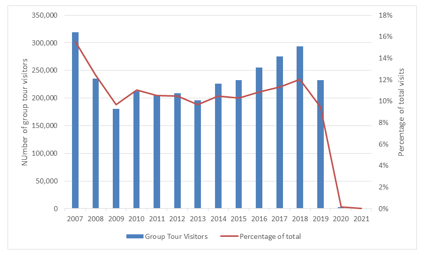
Text description
| Group Tour Visitors to Jasper National Park | |||||||||||||||
|---|---|---|---|---|---|---|---|---|---|---|---|---|---|---|---|
| Year | 2007 | 2008 | 2009 | 2010 | 2011 | 2012 | 2013 | 2014 | 2015 | 2016 | 2017 | 2018 | 2019 | 2020 | 2021 |
| Group Tour Visitors | 319,073 | 235,246 | 180,305 | 212,072 | 204,011 | 208,522 | 196,247 | 226,219 | 232,090 | 255,155 | 274,911 | 293,216 | 232,477 | 2,347 | 0 |
| Percentage of Total | 15.5 | 12.4 | 9.7 | 11.0 | 10.5 | 10.5 | 9.7 | 10.5 | 10.3 | 10.8 | 11.3 | 12.0 | 9.4 | 0.1 | 0 |
Increases in visitation are causing congestion and crowding at popular areas and facilities in the Park, and if not managed well, can impact visitor enjoyment and ecological integrity. The new management plan commits Parks Canada to apply visitor use management tools to maintain a safe and quality visitor experience that protects the Park's ecological and cultural resources.
In 2020 visitation was significantly impacted by travel restrictions as a result of the coronavirus pandemic. Visitation decreased in 2020, compared with 2019 levels, although it rebounded in 2021 and is expected to continue to increase over the life of the management plan through to 2032.
5 Public, Indigenous and stakeholder consultation
Consultation on the development of a new management plan for Jasper National Park took place from 2019-2021. Consultation activities were coordinated with the other Parks Canada mountain national parks, who were developing new management plans at the same time, to enable Canadians to provide general and site-specific input on mountain national park management.
A first phase of consultation on the management plan was held in 2019. The goal of this scoping phase of consultation was to determine the topics Indigenous partners, stakeholders and the public thought were important to consider during development of the draft plan and how they wanted to be engaged going forward. The public was invited to provide feedback through online surveys, public meetings and workshops, and face-to-face forums. Additional meetings were held with stakeholder organizations and other levels of government. Parks Canada met with the more than 20 Indigenous communities with established connections to Jasper National Park at two all-partner meetings in 2019.
During Phase 1 of consultation most of the input came through the "Let's Talk Mountain Parks" webpage, an online engagement platform. Input was received from Canadians across the country, with the majority of comments coming from residents of Alberta and British Columbia.
Feedback received from the public, Indigenous partners, and stakeholders during the initial consultation phase included input that Parks Canada should:
- Incorporate Indigenous knowledge into all parts of park operations and management and collaborate with Indigenous peoples on wildlife conservation and managing development;
- Find a balance between quality visitor experiences and ecological integrity, evaluate the ecological and social carrying capacity of the Park and develop visitor use management strategies;
- Work to adapt to climate change by mitigating cumulative effects and making the Park more energy efficient and operationally sustainable;
- Address concerns regarding declining biodiversity, climate change and increasing human pressures on natural ecosystems, including wildlife displacement and habitat connectivity/fragmentation; and
- Address human-wildlife coexistence issues, such as wildlife habituation and conflicts, educate visitors on how to behave around wildlife, foster wilderness etiquette and responsible use of the Park, and increase presence of uniformed Parks Canada staff presence in key areas to enhance compliance.
The input gathered from this first phase of consultation was used to prepare a draft of a new management plan for Jasper.
Climate change, visitation management, and activities outside of park boundaries are discussed throughout this strategic environmental assessment. Human-wildlife coexistence issues are discussed in the carnivore section (sec. 6.11). Other comments related to mitigations are addressed throughout.
After delays due to the coronavirus pandemic, a second phase of consultation took place in the Spring and Summer of 2021. In this phase, Parks Canada presented a Draft Management Plan to Indigenous partners, stakeholders, and the public, and asked for feedback on the draft. The public was invited to provide feedback through the "Lets Talk Mountain Parks" website, and through 2 virtual open houses. 2,400 individuals visited this webpage, and over 1000 comments were provided through the online survey and virtual ideas board. 17 stakeholder organizations provided feedback through 11 virtual discussions, and 22 different Indigenous groups participated in consultation activities. Parks Canada received over 1,400 letters from interested parties on the draft plan.
Parks Canada considered each piece of feedback received from consultations and used it to revise and refine the draft management plan. For example, in response to feedback, Parks Canada:
- Strengthened language in the plan around climate change and the importance of adapting to and mitigating its effects;
- Clarified direction around how visitor use management strategies and tools will be applied to protect ecological integrity and ensure high quality visitor experiences;
- Created a new objective and associated targets on caribou, to emphasize the importance Parks Canada places on preserving caribou on the landscape, to reflect that Parks Canada will be implementing access restrictions to caribou habitat, and to highlight that Parks Canada will be pursuing a conservation breeding and herd augmentation program, pending impact assessment and consultation;
- Created a new objective and targets on accessibility, inclusion, and diversity, to emphasize that Parks Canada will strive to make Jasper National Park a safe, welcoming, and inclusive place for people of all identities and backgrounds; and
- Created a new objective on trails, to reflect the high volume of feedback on trail use, and to signal that Parks Canada intends to work to promote harmonious relationships between trail users and wildlife and between different user groups.
6 Cumulative effects and strategic mitigations
Cumulative effects were identified and analyzed for each valued component. A summary of the potential effects for each valued ecosystem component along with existing strategies for managing these are provided. Strategic mitigations are discussed in the detailed explanation for each valued ecosystem component that follows.
6.1 Glaciers
Area covered by glaciers is an Ecological Integrity Monitoring Program (EI monitoring program) measure. It is based on measurements taken annually on the Athabasca Glacier and an analysis of total glacier area change over time across the Park, mapped using satellite imagery. This measure is rated as poor and decreasing (Parks Canada Agency 2018a).
Glaciers in Jasper are expected to continue to melt, and the trend for this EI monitoring program measure is expected to continue to decline. Climate change scenarios in Jasper show that the warming trend observed over the last century (2.5°C) is projected to continue (Parker 2019). Melting glaciers are anticipated to contribute to ecosystem-level shifts in the Park (e.g., increasing glacial water flow over the short term, declining water flows and warmer rivers over the long term).
The management plan includes a target for Parks Canada's operations and third party operators to reduce their greenhouse gas emissions and work towards being carbon neutral, and the State of the Park Report (Parks Canada Agency 2018b) emphasizes the importance of, and opportunity for, meaningful outreach and education on climate change in Jasper, especially at the Columbia Icefield Discovery Centre. In the absence of larger regional and global commitments, glaciers are likely to continue to melt.
Conclusion
Climate change is the primary stressor impacting glaciers. There are minimal actions that can be taken to mitigate the effects of climate change at the park scale, and the status of glaciers is likely to continue to decline. The management plan is not expected to contribute additional negative cumulative effects on glaciers and does not include objectives for mitigation.
6.2 Hydrology
The assessment of the hydrology valued ecosystem component includes an examination of how aquatic ecosystems are connected and water volumes are affected. Other aspects of the aquatic ecosystem (water quality, aquatic communities) are examined in subsequent sections of this strategic environmental assessment.
Current status
Aquatic connectivity is an Ecological Integrity Monitoring Program measure which assesses the impact of human crossing structures and infrastructure on the capacity for fish to move through ecosystems. In 2018, aquatic connectivity was assessed to be fair. 17% of Jasper National Park sits in catchments upstream of human water-crossing structures and culverts. 39% of these structures present a barrier to fish movement (Parks Canada Agency 2018a).
Impacts on hydrology have occurred from infrastructure associated with Highway 16 and the Icefields Parkway, following the Athabasca, Sunwapta and Miette rivers, and the CN railway line following the route of Highway 16. The building of the rail line, Icefields Parkway, and the highway took place at a time when there was little consideration of aquatic impacts, and rivers and creeks were altered to provide the best alignment for the transportation corridor. Ongoing infrastructure development and activities to support the railway and the highway (e.g., impediments, diversions and rock armouring) also impact hydrology in Jasper National Park.
Electricity in Jasper is provided primarily by the ATCO transmission line, with additional local generation by the Astoria hydroelectric facility. About 20% of the water that flows through the Astoria River enters the Astoria hydroelectric facility. This water is returned to the Athabasca River rather than the Astoria River, and therefore impacts the hydrological regime along the lower reach of the Astoria River.
Water is withdrawn by leaseholders and Parks Canada, and water quantity is affected by increased visitation and climate change. Key leaseholder water users include residents and businesses in the Municipality of Jasper, the Fairmont Jasper Park Lodge hotel and golf course, and Marmot Basin ski hill. Water for the Municipality of Jasper is taken from wells. Water for the Jasper Park Lodge hotel and golf course is drawn from lakes, a water storage facility damming spring runoff, and wells. Marmot Basin draws water from Basin Creek. Both Sunwapta Falls Rocky Mountain Lodge and Columbia Icefield Discovery Centre draw water from the Sunwapta River. All of these sources are tributaries of the Athabasca River.
Leaseholders are increasingly required to meter their water usages, although some information on water withdrawals are interpolated from wastewater discharge. There are no thresholds to limit water withdrawal during periods of low flow. Potential ecological impacts due to low water quantity are not currently monitored in Jasper.
Analysis
Changes to hydrology may occur in the next 10 years, primarily from climate change, potentially associated with changes in forests, and to a smaller degree, from local changes in stream channel migration, deposition and erosional patterns that are associated with interventions to protect highway, railway and pipeline infrastructure.
Climate change will impact flow volume of rivers and creeks in Jasper. More extreme rain events are likely in climate change scenarios, and today's "one in 100 year" rainfall events in Jasper (22–48 mm/h) are projected to become more frequent, up to "one in 25 year" events (Parker 2017). The maximum rate of ice volume loss, which corresponds with the peak input of glacial meltwater to streams and rivers, is projected to occur around 2020–2040 (Parker 2017). After this peak has occurred, the flow volumes in the Athabasca River and its tributaries are expected to be reduced. As a result, monitoring water flow rates and water withdrawal rates at facilities that use surface water will become more important.
In managing interventions to protect major infrastructure, Parks Canada will opt for solutions that allow to the greatest extent for natural migration of rivers across the span of their flood plains. Armouring of riverbanks at some sites may be considered when necessary to increase resiliency to higher anticipated peak flows, and with full consideration of the ecological and hydrologic impacts.
Forests in Jasper have seen changes due to mountain pine beetle, as discussed more extensively in the Forest Vegetation section (sec. 6.6). Significant forest mortality will have a large impact on the ability of the landscape to absorb water and to buffer stream and overland flow from heavy precipitation events. Mass wasting, landslides and mudslide events are predicted to become more common occurrences as a result of mass pine tree loss from mountain pine beetle.
Gravel extraction is used to maintain highways and roadways in Jasper. The existing Mile 8/9 pit will be the main source of gravel for Parks Canada projects on Highway 16 and the Icefields Parkway. If additional capacity is needed in the south of the Park, the Ranger Creek South pit would be used. Any potential expansion of gravel pits will follow Parks Canada's National Gravel Directive and the Mountain Parks Aggregate Management Strategy, and therefore is not anticipated to have adverse effects on hydrology (Parks Canada Agency 2019a).
Modest growth of 0.1%-0.3% is anticipated in the Community of Jasper over the next 10 years (Municipality of Jasper and Parks Canada 2011). This, combined with increased visitation and associated improvements to supporting infrastructure, will increase water use in the Park. It is, however, unlikely that any increase in surface water withdrawal would be sufficient to cause adverse ecological effects within the lifetime of this plan.
Marmot Basin estimates that an additional 1,800 m3 of water is required to accommodate future skier capacity, as approved in the Marmot Basin long-range plan (Ski Marmot Basin 2014). Climate change projections show increases in temperature in Jasper, which will result in increasing fractions of precipitation falling as rain, rather than snow (Parker 2017). This may increase Marmot Basin's reliance on snowmaking, which will increase their overall water take. Given the peak glacial melt is within the life of the new management plan, the withdrawal is unlikely to be an issue but will need to be considered more carefully in the future.
Mitigations
| Desired Outcomes | The management plan outlines the following desired outcomes for hydrology:
|
| Strategic Mitigations | The management plan commits Parks Canada to achieving the following targets. Achieving the results outlined in these targets will mitigate potential adverse cumulative effects on hydrology:
|
| Project-Level Mitigations | This strategic environmental assessment identified the following additional mitigation, which Parks Canada will apply through the impact assessment of individual projects, to further minimize potential impacts on hydrology:
|
Conclusion
Climate change and visitation are the cumulative effects that will impact hydrological function over the next 10 years. The implementation of the management plan will address the main threats to water connectivity. The management plan is not expected to contribute to additional negative cumulative effects on water quantity.
| Confidence Level | Rationale | |
|---|---|---|
| Quality of information sources on valued component | Low | Water quantity is not part of EI monitoring program; limited to no baseline data. |
| Quality of information sources on sources of impacts | Medium | Given the uncertainties in predicting climate change, the high influence of climate change on this VC creates low confidence in predictions. Additionally, recent trends in visitation are variable, and limited data on visitor use within the Park is available. |
| Understanding of pathways of effects | Medium | Moderate understanding of pathways of effects. |
| Analysis of VC | Low | Analysis of this VC is based on precedent/past experience, expert opinion, and observational information. |
6.3 Water quality
The assessment of the water quality valued ecosystem component is based on the water quality indicator in the Active Management Effectiveness Monitoring program and the Stream Biotic Health indicator in the Ecological Integrity Monitoring program. Athabasca River water quality has scored from good to excellent from 2007 until 2016; however, within the range of good, the water quality index has been consistently decreasing (Parks Canada Agency 2018a). Stream biotic health is rated as good in the Park (Parks Canada Agency 2018a). The overall good water quality, due to the pristine nature of the vast majority of the Park, may miss localized areas where water quality is being impacted by wastewater discharge to water or ground, or to stormwater runoff.
Aspirational Mountain National Park Leadership Targets for discharge of wastewater effluent into water (Leadership Targets) were identified in the 2000 and 2010 Jasper National Park management plans to protect ecological integrity, and are being implemented, with some adjustments for operational realities. Wastewater treatment systems operate at the Municipality of Jasper, Sunwapta Falls Rocky Mountain Lodge, Miette Hot Springs, Marmot Basin, the day lodge at Maligne Lake, and the Columbia Icefield Discovery Centre. Several of the commercial accommodation facilities outside of the Jasper townsite and the Parks Canada Palisades Centre operate with septic fields. Wastewater from day use areas and smaller campgrounds (vault privies, etc.) is pumped out (or flown out in the case of high use backcountry privies) and transported to the Municipality of Jasper wastewater treatment plant. Three wastewater facilities discharge into water — the Municipality of Jasper, Miette Hot Springs and Sunwapta Falls Rocky Mountain Lodge. The facility at Miette is meeting the outlined Leadership Targets, while the other two facilities generally meet the Leadership Targets, with the exception of nutrients, in particular, phosphorus. Parks Canada is working with the Government of Alberta to standardize expectations for municipal wastewater effluent.
Wastewater from the Columbia Icefield Discovery Centre is treated and then discharged onto gravel. Effluent is monitored at end of pipe at the Discovery Centre to ensure it meets standards set through permits. Septic fields are also used to manage wastewater in other areas of the Park. The management plan includes targets to ensure that wastewater effluent meets Parks Canada standards and/or applicable provincial standards, and that aquatic ecosystems will be restored for water quality.
Waterbodies will be protected from contamination through project design and through the impact assessment of each project to ensure wastewater treatment systems have appropriate system selection, appropriate site selection, and sufficient capacity.
The Municipality of Jasper and Parks Canada continue to enhance stormwater management; however, metals, hydrocarbons and fecal coliforms enter Jasper's waterbodies due to insufficient stormwater management in the Municipality of Jasper (Environmental Sciences Group 2019). Other sources of runoff affecting water quality in the Park include salting of the highways, spills, and the municipal compost site. When spills occur, Parks Canada responds to them in accordance with the Jasper National Park Spill Response Internal Procedures protocol.
Climate change may increase river flash flood events. This will increase the frequency of water quality measurements outside of reference conditions and contribute to wastewater treatment plants exceeding standards (Parks Canada Agency 2018a).
Conclusion
Climate change and increases in visitation could contribute to cumulative effects on water quality. The management plan indicates that wastewater in the Park must meet Parks Canada standards and/or applicable provincial standards. With investment and ongoing operational adjustments by operators to implement this direction, the implementation of the management plan is expected to maintain and likely improve water quality in the Park.
6.4 Aquatic communities
This valued ecosystem component was assessed based on the following indicators: The ecological integrity monitoring program's lake fish index and river fish index and the status of two aquatic species at risk: Bull Trout, Saskatchewan-Nelson Rivers populations (Salvelinus confluentus) and Rainbow Trout, Athabasca River population (Oncorhynchus mykiss).
Current status
The lake fish index is based on the percentage of lakes in Jasper that remain in their natural, historical fish community state. This measure shows how fish stocking has changed the aquatic assemblage at a landscape scale (Parks Canada 2018a). In 2018, the lake fish index was rated as fair, as only 53% of lakes met this criterion. Historical stocking of lakes was common throughout the first 75 years of Jasper's existence, and it has put native fish species at risk and has significantly affected aquatic food webs (Parks Canada 2018a).
The river fish community measure is based on the species diversity, fish density, sucker proportion, keystone species proportion, and native trout proportion of the Athabasca River. In 2018, this measure was assessed as good and improving (Parks Canada 2018a). As whirling disease was found in Banff National Park in August 2016, surveys are ongoing in Jasper, however, no evidence of the disease has been found so far.
The aquatic species at risk in Jasper are Bull Trout and Rainbow Trout. They are listed as Threatened and Endangered under Schedule 1 of SARA, respectively. The greatest risk to these species in Jasper is hybridizations with non-native fish species. Habitat changes due to impoundment, road building and stream crossings, and poorly designed culvert stream crossings also play a role in their decline, particularly regionally beyond park boundaries.
Analysis
The primary pressures on aquatic communities stem from historical fish-stocking practices combined with pressures resulting from climate change, with the risk of invasive species and diseases having the potential to further exacerbate the effects of these pressures.
Historical stocking of waterbodies with non-native fish species remains the source of the largest negative impacts to native fish communities in Jasper. The most effective way to improve the ecological integrity of aquatic communities is to restore these waterbodies to their natural, pre-stocking state such that they contain only native species or return to their previous fishless state. Returning waterbodies to their natural state will also reduce the likelihood of hybridization for the two aquatic species at risk.
Climate change is projected to have a negative effect on the aquatic communities in Jasper (Parks Canada Agency 2018a). Warming water temperatures and changes to flow regimes are both anticipated under climate change models (Parker 2017; Parker 2019). Changes in water temperatures may result in a competition-driven shift from cold-adapted fish species to other species in glacier-fed watersheds (Andison et al. 2009). Jasper is projected to continue to experience earlier and more rapid snowmelt in the spring. Warmer, drier summers will contribute to drought conditions in parts of the Park, which may be exacerbated by melting glaciers at the headwaters, resulting in higher volumes of water in the immediate future, followed by less water in the watersheds (Parker 2017; Parker 2019). The Canadian Rocky Mountains have experienced flow declines of 0.22% per year from 2002 to 2010, which in combination with warming waters will reduce the amount of thermally suitable habitat for many aquatic species (Parks Canada Agency 2018a). This has the potential to exacerbate negative effects experienced by both Bull Trout and Rainbow Trout.
Wildfire season is anticipated to increase in Jasper as a result of climate change (Parker 2019). While wildfire is a frequent and natural disturbance, it can lead to decades-long elevation of summer stream temperatures. In the short term, wildfires can remove substantial streamside vegetation, resulting in reduced shading, increased temperatures, changes in water chemistry, erosion and turbidity, and fewer terrestrial invertebrates in the stream (Parks Canada Agency 2018a).
Lakes, rivers and streams are sensitive sites. Any negative impacts in one area may have the potential to quickly spread to other areas. Increased use of lakes and rivers by visitors with personal recreational watercraft increases the likelihood of alien and invasive species introduction to Jasper's waterbodies. Road-accessible lakes are at the greatest risk for contamination. Whirling disease, zebra mussels and quagga mussels are all at high risk to be introduced in Jasper. Didymosphenia geminata (didymo) is present in Jasper and is at risk of spreading further.
Mitigations
| Desired Outcomes | The management plan outlines the following desired outcomes for aquatic communities:
|
| Strategic Mitigations | The management plan commits Parks Canada to achieving the following targets. Achieving the results outlined in these targets will mitigate potential cumulative effects on aquatic communities:
|
| Project-Level Mitigations | This strategic environmental assessment identified the following additional mitigations, which Parks Canada will apply through the impact assessment of individual projects, to further minimize potential impacts on aquatic communities:
|
Conclusion
Historical stocking of lakes with non-native species continues to be the largest factor negatively influencing aquatic communities. Climate change and increases in visitation and water-based recreation may also contribute to cumulative effects by changes in aquatic habitat and increasing the risk of contamination and introduction of invasive species and disease. The management plan provides direction on managing aquatic communities by preventing the establishment of new invasive species and diseases, and controlling and eliminating existing invasive species. With these initiatives, the implementation of the management plan is expected to improve aquatic communities in Jasper National Park.
| Confidence Level | Rationale | |
|---|---|---|
| Quality of information sources on valued component | High | Good information collected over an appropriate time frame and whole applicable area of park |
| Quality of information sources on sources of impacts | High | Limited influence of climate change, consistent visitation and good visitor use data, and limited development possible around the Park. |
| Understanding of pathways of effects | High | Good understanding of pathways of effects |
| Analysis of VC | Medium | Analysis is based on non-site-specific scientific modelling data, quantitative studies from multiple peer-reviewed sources where the correspondence to project-VC interaction is less precise, and qualitative studies. |
6.5 Wetlands
Wetlands maintain water quality, regulate hydrological events, and provide habitat to support biodiversity. Amphibian occupancy is an Ecological Integrity Monitoring Program measure that can be used to infer wetland quality. This measure is based on presence of four amphibian species at 60 random sites, which are surveyed every three years. It is rated as good and stable in Jasper (Parks Canada Agency 2018a).
The primary threat to wetlands in Jasper is climate change. Changes in temperature and precipitation patterns are anticipated to have effects on wetland extent and location. Although increased spring and summer flows may extend wetland areas seasonally, trends of reduced glacier extent and mass are predicted to continue, which may result in reduced recharge of wetland areas, increased evaporation, and consequently reduced wetland extent and altered wetland locations (Derksen and Brown 2012). Precipitation patterns are also projected to change, and some parts of Jasper may experience a large decrease in precipitation, while it will increase in other areas (Parker 2019). Collectively, this will potentially contribute to declining hydrologic flows overall. These climatic changes would also impact benthic and amphibian communities, which are vulnerable due to their permeable skin, complex life history, and a dependence on moist terrestrial and wetland habitats.
Increased warming projected by climate change scenarios, in conjunction with increased visitation, will increase the likelihood of invasive plant species establishment, which threatens the ecological integrity of wetlands.
The management plan includes a target to enhance vegetation mapping and develop a vegetation resource inventory by 2024. Updating mapping of wetlands through vegetation resource inventories or wetland classification systems will provide an updated understanding of wetland extent. The inventory could be used to identify which wetlands are at higher risk due to climate change, which will be important for project impact assessment. The inventories will also provide the baseline for measuring future changes. The management plan includes a target to finalize the Jasper National Park Vegetation Management Strategy by 2024 and have this strategy include restoration targets for priority habitats such as riparian vegetation. This will provide clear direction on protecting sensitive habitats within the Park. The management plan also includes targets to conduct outreach and education programs to reduce the risk of invasive species introductions, to restore priority habitats, to implement the invasive plant and integrated pest management strategy, to work with utility, pipeline, and transportation companies to find ways to minimize their impacts on sensitive habitats, and to engage in targeted activities and communications to advance understanding and stewardship of natural resources in sensitive areas of the Park. These mitigations will reduce the impact of non-climactic stressors on wetlands. Mitigations to protect wetlands will also be applied through project-level impact assessments.
Conclusion
Climate change and invasive species introductions are the main sources of cumulative effects on wetlands. The management plan provides direction on reducing knowledge gaps, providing direction on protecting sensitive habitats, and advancing visitor understanding and stewardship. As a result, the implementation of the management plan is expected to maintain the ecological integrity of wetlands in Jasper National Park.
6.6 Forest vegetation
Current status
Since the establishment of Jasper National Park in 1907, Parks Canada has suppressed wildfires in the Park. Reintroduction of prescribed fires began in the 1980s, but the scale and frequency has not compensated for the loss of fire disturbance from removing Indigenous ignition practices and applying wildfire suppression actions after World War II.
There are four reference fire regime areas in Jasper:
- Montane (50-year fire cycle);
- Lower Subalpine (100-year fire cycle);
- Upper Subalpine (200-year fire cycle); and
- Old Growth (400-year fire cycle).
All of Jasper's fire regimes except for Old Growth are rated as having a poor area burned condition class (Montane: -86%; Lower Subalpine: -88%; Upper Subalpine: -79%; Old Growth: -33%) (Parks Canada Agency 2018a).
The 2019 Canadian Forest Service surveys indicated that the mountain pine beetle infestation is declining compared with 2017 in the Park (Brett 2019). This was likely due to a prolonged cold period in February 2019, as anything below -37°C is known to cause serious mortality in the insects (Brett 2019). Sub -40°C temperatures were observed again in January 2020, which will also curb the extent of the outbreak. Tree mortality will likely continue in some areas, including along the Icefields Parkway between Lick Creek and south of Sunwapta Falls, and in the Snaring, Snake Indian, Moosehorn, Maligne, and Fiddle valleys as previous years' mountain pine beetle attacks take hold (Brett 2019) (Figure 6).
Other outbreaks observed during 2017 surveys included western balsam bark beetle, aspen serpentine leafminer, Douglas-fir beetle, Elytroderma needle cast and spruce needle rust (Brett 2017). Drought is also known to impact forest health and was observed affecting lodgepole pine and aspen during the 2017 surveys (Brett 2017).

Text description
This map shows the extent of mountain pine beetle surveys within Jasper National Park, in 2018 and 2019.
A legend is shown in the top right corner, and includes a 0 to 50 kilometre scale bar. A north arrow, pointing up, is located in the top left corner of the map.
Jasper National Park lands are shown in green, with the Alberta-British Columbia border indicated with a thick black line. Lands outside of the park boundary within Alberta and British Columbia are shown in white.
The towns of Jasper, Cadomin, Robb and Hinton are indicated by yellow dots.
Highway 16 is shown running east-west through the park's northern third and the 93N runs north-south through the southern two-thirds of the park.
The extent of the 2018 mountain pine beetle survey is shown in black, and ta kes up an area of 162,700 Ha. The majority of this area is located in the central portion of the park surrounding the town of Jasper, and extends more than 50 kilometres south of town along the Athabasca River Valley, west of town along the Miette River Valley to the British Columbia border, and more than 50 kilometres north of town along the Athabasca River Valley, and continues along the Snaring and Snake Indian River Valleys.
In the eastern portions of the park, pine beetle survey is shown along the Maligne River valley, the southern extent of the Rocky River Valley, and the Fiddle River Valley.
Additional smaller isolated patches are scattered in the park's northern portion.
The extent of the 2019 mountain pine beetle survey is shown in red, and takes up an area of 229,174 Ha – a 30% increase over 2018. In general, this area is contiguous with the 2018 area, and represents an expansion at the boundary edges.
A line graph is located in the lower left corner of the map, showing the progression of mountain pine beetle-affected area within Jasper National Park between 2013 and 2019.
Graph text:
| Area of Mountain Pine Beetle Surveys 2013 to 2019 | |||||||
|---|---|---|---|---|---|---|---|
| Year | 2013 | 2014 | 2015 | 2016 | 2017 | 2018 | 2019 |
| Hectares | 123 | 6,251 | 21,600 | 48,600 | 93,156 | 162,700 | 229,176 |
Forests in Jasper National Park have changed extensively due to mountain pine beetle. Mountain pine beetle-killed trees can be a hazard to people and infrastructure, and require removal where they pose a threat, such as around campgrounds and electrical lines. As a result, removal of these trees has contributed to a considerable amount of forest clearing in the Park.
Invasive and alien plant surveys were last conducted in 2010 along segments of roads in Jasper (Eastern Slopes Rangeland Seeds 2010). The 2010 survey found high-priority invasive species along all stretches of roads that were surveyed, with the exception of Snaring-Celestine Road (Eastern Slopes Rangeland Seeds 2010). Invasive species had on average a significantly higher cover and diversity on Highway 16 than anywhere else in Jasper (Eastern Slopes Rangeland Seeds 2010).
Analysis
Forests are at risk of further declines under climate change scenarios. The wildfire season is expected to increase by 20–60 days in most of Jasper (Parker 2019). The warmer, drier climate predicted under climate change scenarios is expected to increase the likelihood of forest insect and disease outbreaks, such as mountain pine beetle (Parker 2019). Changes in precipitation patterns may shift forest species composition (Parker 2017) and forest insect and disease infestations or outbreaks.
Mitigations
| Desired Outcomes | The management plan outlines the following desired outcomes for forest vegetation:
|
| Strategic Mitigations |
The management plan commits Parks Canada to achieving the following targets. Achieving the results outlined in these targets will mitigate potential adverse cumulative effects on forest vegetation:
|
| Project-Level Mitigations | The management plan includes the following targets, which will further mitigate potential adverse impacts to forest vegetation, which Parks Canada will implement through the impact assessment of individual projects:
|
Conclusion
The main sources of cumulative effects on forests are fire suppression, insects and disease, and climate change. The management plan provides direction for management of some of these processes and pressures, and as a result, its implementation is expected to improve the health of forest vegetation in Jasper National Park.
| Confidence Level | Rationale | |
|---|---|---|
| Quality of information sources on valued component | High | Good information collected over an appropriate time frame and whole applicable area of park. |
| Quality of information sources on sources of impacts | Medium | Given the uncertainties in predicting climate change, the high influence of climate change on this VC creates medium confidence in predictions. |
| Understanding of pathways of effects | Medium | Moderate understanding of pathways of effects. |
| Analysis of VC | Medium | Analysis of VC based on non-site-specific scientific modelling data, quantitative studies from multiple peer-reviewed sources where the correspondence to project-VC interaction is less precise, and qualitative studies. |
6.7 Montane habitat including grasslands, wet meadows and dunes
The montane ecoregion covers approximately 7% of Jasper and provides important habitat for wildlife. In particular, grasslands located at valley bottoms are important wildlife habitat. However, these areas are popular with visitors, and the majority of Jasper's developed areas and infrastructure are located in this ecoregion, including the Community of Jasper, the Jasper Airstrip, Highway 16, the CN rail line, oil and natural gas pipelines, electrical transmission lines, and most visitor and operational facilities. A history of fire suppression in Jasper may have also contributed to a reduction in grassland from its historical extent (Rhemtulla et al. 2002).
Climate change risks the integrity of montane grassland ecosystems through woody plant encroachment and changes in species composition (Parker 2017). However, increases in wildfire may support grassland expansion.
The management plan includes a suite of targets to limit new disturbance in the montane, including completing inventories, monitoring, and maintaining or increasing the area of priority habitats, particularly montane grasslands and dune ecosystems. The management plan includes targets to improve vegetation mapping and develop a vegetation resource inventory, which will help ensure impacts on montane habitats are minimized during project-level impact assessments. The management plan target to complete aJasper National Park Vegetation Management Strategy, including restoration targets for priority habitats such as montane grasslands, by 2024 will provide clear direction on protecting sensitive habitats within the Park.
The management plan also includes a target to review ecological, asset maintenance and aviation safety concerns for the Jasper Airstrip, which is located in the montane grassland ecosystem, to determine if the asset continues to be an appropriate use of land. If the airstrip is closed, this could result in ecological gains.
Conclusion
Climate change and operation and maintenance activities for highway, utility and railway infrastructure, and the Jasper Airstrip are the main cumulative effects impacting montane grassland and dune environments. The management plan provides direction to manage impacts from infrastructure projects, and as a result, its implementation is expected to maintain montane grassland and dunes in Jasper National Park.
6.8 Alpine habitat
Climate change is the main driver predicted to influence alpine habitat and vegetation in Jasper over the next 10 years. Warming temperatures will increase the growing season length and may lead to shrub expansion in Jasper's alpine (Parker 2017). Wetter summers and drier winters may change the species composition in these plant communities and may facilitate alien and invasive species establishment (Parker 2017). Mapping of alpine habitat through vegetation resource inventories will provide a baseline of alpine extent against which impacts of climate change can be measured.
Alpine vegetation condition is a new Ecological Integrity Monitoring Program measure in Jasper National Park. The alpine vegetation condition measure uses repeat photography and satellite imagery to determine a condition rating. A baseline for alpine vegetation condition will be established in advance of the next State of the Park Assessment, and a condition and trend will be assessed every 10 years.
Increased visitation on alpine trails increases the likelihood of habitat degradation. Appropriate infrastructure including maintained trails, boardwalks and outhouses can prevent negative effects of increased visitation on alpine habitat. The management plan includes a commitment to carry out targeted activities and communications to advance understanding and stewardship in high-use, sensitive, and impacted areas of the Park.
Completing aJasper National Park Vegetation Management Strategyis a target of the new management plan, including restoration targets for priority habitats to provide clear direction on protecting sensitive habitats within the Park.
Reducing the impact of non-climatic stressors on alpine habitats during project approvals includes designing projects to:
- Limit their expansion into the alpine habitat;
- Include robust measures to prevent invasive species establishment; and
- Include reclamation and restoration targets associated with project approvals.
These considerations will be incorporated in project-level impact assessments to minimize cumulative impacts to sensitive alpine ecosystems.
Conclusion
Climate change and visitation are the primary cumulative effects impacting alpine habitats. There is uncertainty about the future trend and condition of alpine habitat as a result of climate change. The implementation of the management plan is not expected to contribute additional negative cumulative effects on alpine habitats in Jasper National Park.
6.9 Whitebark pine
Whitebark pine (Pinus albicaulis) is a high-elevation pine species that is listed as Endangered on Schedule 1 of SARA. Whitebark pine is considered an important species in upper subalpine forests where it provides critical food, habitat, and snowpack stabilization (Farnes 1990; Callaway 1998; Campbell and Antos 2000; Parks Canada Agency 2018a). The extensive population decline of whitebark pine has been attributed to the combined effects of mountain pine beetle outbreaks, fire exclusion policies, spread of the exotic disease white pine blister rust, and climate change.
Regional mountain national park assessment
Collaborative conservation and restoration programs across the mountain national parks and with the governments of Alberta and British Columbia have been developed to monitor the health and status of whitebark pine and reduce future declines. For this reason, the health and status of whitebark pine are assessed regionally at the mountain national park scale in addition to at the Jasper National Park level. Active management and restoration activities ongoing across the mountain national parks focus on creating favourable habitat and planting seedlings resistant to the introduced white pine blister rust pathogen. The objectives of these activities are to lessen declines of whitebark pine populations and ensure they persist in the mountain national parks in perpetuity.
The conservation and recovery measures for whitebark pine across the mountain national parks, as indicated in the multi-species action plans for each park (Parks Canada Agency 2017), are as follows:
- Identify rust resistant individuals (Plus Trees) at high-priority sites. Conduct Plus Tree seed resistance testing. Protect high-value Plus Trees from mountain pine beetle;
- Plant apparent rust resistant seedlings, and when available, confirmed rust resistant seedlings, in priority restoration sites. Inoculate seedlings with mycorrhizal fungi to improve survival;
- Protect and, where feasible, increase the number and extent of existing stands of blister rust resistant individuals through habitat management and restoration;
- Implement prescribed fire to restore lost habitat;
- Collect seed for genetic conservation;
- Complete a predictive habitat model and map of whitebark pine distribution. Where stand assessments are completed, they include aspects of stand health (i.e., rust presence/absence and stand density); and
- Continue communication activities aimed at reducing human-caused impacts on whitebark pine as outlined in the Whitebark Pine Conservation and Restoration Project.
Maintaining a fire regime on the landscape that mimics natural fire cycles, as committed to in the management plan, can benefit whitebark pine. Under current climate change scenarios, forest fires are predicted to be more frequent and severe and therefore may contribute to tree mortality. Low- and moderate-intensity fires provide more favourable conditions for the regeneration of whitebark pine and present a restoration opportunity (ECCC 2017; Parks Canada Agency 2018a; Parker 2019). Climate change could further impact whitebark pine in a variety of ways, including higher risk of mountain pine beetle infestation, severe fires, geographic shifting of climatically suitable habitat faster than the pines can migrate and establish, and stress on seed banks and tree viability as a result of extreme temperatures (ECCC 2017).
Jasper assessment
Impacts from proposals within the management plan are anticipated to have no important negative effects on whitebark pine. However, whitebark pine in Jasper is expected to continue to be impacted by the threat of white pine blister rust (Shepherd et al. 2018; ECCC 2017). Continued participation in collaborative efforts to maintain habitat and restore healthy populations, as committed to in the management plan, will be key to their conservation and restoration across the landscape. Collaborative initiatives with federal and provincial partners to manage and restore whitebark pine in Alberta and British Columbia are key to achieving local and regional conservation objectives. The site-based population and distribution objectives for whitebark pine in Jasper are to establish a self-sustaining, rust resistant population of whitebark pine throughout the species range that demonstrates natural seed dispersal, connectivity, genetic diversity, and adaptability to changing climate. Restoration activities including targeted conservation and restoration programs and the ongoing Ecological Integrity Monitoring Program coordinated across the mountain national parks will help ensure continued progress on conservation and restoration objectives outlined in Jasper's multi-species action plan (Parks Canada Agency 2017).
Conclusion
The main sources of cumulative effects on whitebark pine include white pine blister rust and climate change. The implementation of the management plan, the recovery strategy prepared under the SARA, and Jasper's multi-species action plan will collectively address the main threats to whitebark pine inside the Park and provide the best efforts for its recovery in Jasper National Park.
6.10 Terrestrial birds
Impacts to wildlife habitat, including that of terrestrial birds, is discussed in sections 6.5–6.8. The assessment of the terrestrial bird valued ecosystem component is based on the Ecological Integrity Monitoring Program measures for forest and alpine birds. Both measures were assessed to be in fair condition in 2018. Terrestrial birds are rated fair because 16% of species and 25% of guilds declined. To measure change, birds were identified by song annually at 130 sites from 2007 to 2016. (Parks Canada Agency 2018a). Climate-related factors, such as spring temperature, influenced bird trends for almost half of the species monitored.
Variability in species' responses to climate change suggests that species-specific approaches continue to be required to assess the effects of climate change, especially for specialist or endangered species. Climate change is anticipated to cause temperature and precipitation changes, which may lead to ecosystem-level shifts, as indicated in the forest and alpine vegetation sections. More extreme spring weather (e.g., increased precipitation, fluctuations in temperature) and longer wildfire seasons may negatively impact fledgling survival and, consequently, occupancy rates.
In a broad-scale analysis of potential bird species turnover, projections for Jasper between the present and 2050 are 23% species turnover in summer and 17% in winter under the intermediate-emissions pathway (Parker and Wu 2019). Eight species might be extirpated from the Park in at least one season by 2050 (Parker and Wu 2019).
Several avian species at risk are present in Jasper, and mitigations to protect Olive-sided Flycatcher and Common Nighthawk are outlined in Jasper's multi-species action plan (Parks Canada Agency 2017). Recovery targets and conservation measures will be developed for species that were listed after the development of the multi-species action plan, including Barn Swallow, Bank Swallow, and Black Swift; these measures will be integrated into an updated multi-species action plan once developed.
The compost facility operated by the Municipality of Jasper attracts a large number of corvids and gulls, which prey on, or displace, terrestrial songbirds. Christmas Bird Count data indicates an increasing population of Common Raven (doubling) since 1983 in the area near the compost facility. While improvements should be made opportunistically to the compost facility, existing monitoring is adequate to assess if this localized effect will have broader impacts that need additional mitigation.
An increase in visitation may result in an increase in people hiking with dogs, including those that are non-compliant with off-leash dogs, which pose a threat to birds, particularly ground nesting species. The management plan includes targets to conduct targeted activities and communications to foster a sense of stewardship amongst visitors and park users. Communication with visitors on the importance of compliance with park regulations to protect ecological integrity will mitigate negative effects of increased visitation on birds. Presence of uniformed staff to ensure compliance with regulations, including off-leash dogs, will further reduce impact of increased visitation on terrestrial birds.
Conclusion
Climate change is the primary predicted stressor on terrestrial birds over the next 10 years. Updating and implementing the multi-species action plan will benefit bird species that are particularly susceptible to climate change. The management plan provides direction for the management of these species and their habitat within the Park, and as a result its implementation is expected to maintain the status of terrestrial birds in Jasper National Park.
6.11 Carnivores
Carnivores that have been identified as particularly vulnerable to cumulative effects in Jasper include wolf (Canis lupus), cougar (Puma concolor), Canada lynx (Lynx canadensis), wolverine (Gulo gulo), black bear (Ursus americanus) and grizzly bear (Ursus arctos).
The primary factors contributing to cumulative effects in relation to carnivores in Jasper are:
- Human-caused mortality and conflict;
- Reduced connectivity; and
- Removal of and displacement from habitat.
6.11.1 Human-caused mortality and conflict
Current status
Human-caused mortality and human-wildlife conflict affect carnivores and ungulates in Jasper National Park. This section examines these two issues by reviewing the current status of park wildlife populations, mortality trends within the Park, mortality sources outside the Park, and human-wildlife conflict trends.
Population status
Wolf density in Jasper is monitored to inform caribou recovery planning, and current estimates are 1.8 wolves per 1,000 km2 (see section 6.12 for detailed information on the caribou predator monitoring). Grizzly bear density in Jasper is 13 per 1,000 km2 (Stenhouse et al. 2015), and black bear density is 29 per 1,000 km2 (available habitat only) (Boulanger et al. 2016). In British Columbia, grizzly population management units adjacent to Jasper are considered to be in good condition, with densities of 20-30 bears per 1,000 km2 (Government of British Columbia 2012). Bear density is naturally lower in the mountain national parks, compared with the Alberta foothills or British Columbia. The population status of other carnivores is not known.
Mortality trends
Carnivores
Most of the carnivores killed in vehicle or railway strikes in Jasper are black bears and wolves. Black bear mortalities due to vehicle strikes are high, and could lead to a decline in population size (Boulanger et al. 2016). The rail line is also likely an important source of mortality for black bears (Bradley, pers. comm. 2020), as spilled grain along the rail line attracts black bears.
The annual number of wolf mortalities is highly variable, averaging about 15% annually. Given wolf recruitment is low, there is uncertainty about whether the mortality rate is exceeding a sustainable threshold (Parks Canada Agency 2018a). Mortalities of smaller carnivores due to vehicle strikes are not reliably reported, which makes it impossible to assess if vehicle strikes are impacting local population sizes.
Parks Canada also monitors human-caused grizzly bear mortalities. The 2010 management plans for Jasper, Yoho, Kootenay, and Banff set a human-caused mortality threshold for adult female grizzly bears of less than 1.2% of the grizzly bear population in order to maintain a sustainable population size. Jasper National Park is currently meeting that target; since 1998, only one grizzly bear has been reported to be killed by a vehicle strike and only one grizzly bear has been reported to have been killed by a train strike. (Parks Canada Agency 2018a).
Regional mortality sources
Grizzly bear hunting ended in 2017 in British Columbia and in 2006 in Alberta, although black bear hunting continues to occur in both provinces (Government of British Columbia 2020; Government of Alberta 2019a). Wolf density is an order of magnitude higher on provincial lands in Alberta than in the Park (Bradley, pers. comm. 2020). Trapping and targeted wolf population reduction programs are underway in Alberta to support caribou recovery. Other carnivore species are subject to trapping in both British Columbia and Alberta (Government of British Columbia 2020; Government of Alberta 2019a). These contributions to the mortality of transboundary carnivore populations will be considered when evaluating whether mortality rates within the Park exceed sustainable thresholds.
Human-wildlife conflict trends
The number of human-wildlife coexistence incidents has increased steadily since the last management plan in 2010. The greatest number of incidents occurs during months where overall visitation is highest. This also corresponds to the months when bears are most active (summer months, from May to September) and when ungulates are calving (May to June).
Human-wildlife conflict is a potential source of mortality and stress for wildlife and poses risks to visitor safety. Although humans and wildlife can come into conflict under many different circumstances, habituated wildlife are more likely to have negative interactions with people, as they typically spend more time close to people and may demonstrate more aggressive behaviour as they lose their natural wariness of humans. Habituated bears are more likely to be killed on roads and rail lines or for management reasons (Gibeau and Stevens 2005).
Carnivore species most frequently involved in human-wildlife conflict are black bears and grizzly bears. Bear conflicts occur mainly in two seasons: ungulate calving season in the spring, and berry season in late summer. Although encounters have risen for both bear species, the change has been more marked for grizzly bears (Figure 7). Parks Canada wildlife managers have hypothesized that the rise in grizzly bear encounters began in 2012 when a late thaw in the alpine resulted in many grizzly bears descending to the valley bottom, where they discovered fresh grass on rights-of-way, roadsides and the golf course, as well as ungulate calves. These bears have since returned to the valley bottom every year, and a number of cubs have been raised with this foraging strategy.
Nineteen out of the 36 bear-human encounters in 2017 occurred in the Three Valley Confluence Bear Management Area, which is the area of the Park that includes the townsite, multiple outlying visitor facilities and an extensive trail network. All of the bear-human encounters were on trails or roads.
Text description
| Number of Bear-Human Encounters in Jasper from 2004 to 2021 | ||||||||||||||||||
|---|---|---|---|---|---|---|---|---|---|---|---|---|---|---|---|---|---|---|
| Year | 2004 | 2005 | 2006 | 2007 | 2008 | 2009 | 2010 | 2011 | 2012 | 2013 | 2014 | 2015 | 2016 | 2017 | 2018 | 2019 | 2020 | 2021 |
| Grizzly Bear Encounters | 1 | 4 | 1 | 1 | 6 | 0 | 0 | 0 | 11 | 11 | 18 | 8 | 17 | 16 | 19 | 25 | 22 | 27 |
| Black Bear Encounters | 4 | 3 | 12 | 7 | 10 | 5 | 7 | 2 | 13 | 9 | 17 | 10 | 16 | 20 | 25 | 51 | 13 | 24 |
Analysis
Vehicle traffic on the major highways in the mountain national parks has increased by an average of 3% a year over the past 10 years, and it is expected to continue to increase. On the Icefields Parkway (Highway 93 North), traffic from June to September has increased 6% a year, or 57% over the past 9 years (Parks Canada Agency 2019b). Although Parks Canada does not have statistics for rail traffic, anecdotal observations suggest that rail traffic along the CN rail line has increased substantially over the last 10 years.
The transportation corridors of Highway 16 and the Icefields Parkway and the CN rail line will remain the largest risk of mortality to carnivores and ungulates in Jasper National Park in the coming decade. A total of 75% of the reported carnivore strikes are related to Highway 16, noting that uncertainty exists about the level of reporting for strikes along the railway (Parks Canada Agency 2018a).
Visitation in Jasper has increased by 32% since 2010. It is anticipated to continue to increase over the next 10 years. Even if bear populations stay at current levels or decline, the number of human-wildlife conflicts are expected to continue to increase as more visitor activity in the Park provides further opportunities for habituation, and as the number of habituated individuals present in park wildlife populations continues to increase. In some cases, displacement of wildlife may reduce human-wildlife incidents, particularly on highly used trails, as there will be fewer incidents if wildlife are not present. Operational mitigation programs that are currently in place, including outreach and education initiatives, wildlife ambassadors and recovering carcasses from areas such as roads or railways, have been effective in mitigating human-wildlife conflict and will be important to continue as visitation increases.
The development of facilities and trails can contribute to increased human-wildlife conflicts if they are located in areas that bring visitors into close contact with wildlife (e.g., high-probability bear movement areas) or contain attractants that draw wildlife into the facility. Conversely, facility and infrastructure upgrades can reduce the potential for human-wildlife conflicts when they are appropriately located, by incorporating measures to reduce or eliminate attractants, and through design elements such as realignments or footprint modifications that increase spatial and temporal separation of people and animals.
Mitigations
| Desired Outcomes | The management plan outlines the following desired outcomes for human-caused wildlife mortality and human-wildlife conflict:
|
| Strategic Mitigations | The management plan commits Parks Canada to achieving the following targets. Achieving the results outlined in these targets will mitigate potential adverse cumulative effects on human caused wildlife mortality and human-wildlife conflict:
|
| Project-Level Mitigations | This strategic environmental assessment identified the following additional mitigations, which Parks Canada will apply through the impact assessment of individual projects, to decrease potential human-caused wildlife mortality and reduce potential human-wildlife conflict:
|
Conclusion
Increasing traffic on park roadways, continued high levels of rail traffic, a variety of natural and artificial attractants in close proximity to visitor facilities, and increasing visitation are expected to contribute to cumulative effects on carnivore mortality and human-wildlife conflict. The management plan provides strategic direction to proactively and reactively manage these sources of wildlife stress and mortality, and includes targets to restore more natural wildlife behaviours and distribution.
Significant effort and coordination within the Jasper Field Unit, and collaboration with third parties will be required to meet the desired outcome. With the mitigations outlined above, and the commitments included in the new Jasper National Park Management Plan, wildlife-human conflict and mortality is expected to stay the same or improve (i.e., decrease conflict and mortality) over the next 10 years.
| Confidence Level | Rationale | |
|---|---|---|
| Quality of information sources on valued component | High | Good information collected over an appropriate time frame and whole applicable area of park. |
| Quality of information sources on sources of impacts | Medium | Recent trends in visitation are variable, and limited data on visitor use within the Park is available. |
| Understanding of pathways of effects | High | Good understanding of pathways of effects. |
| Analysis | Medium | Analysis is based on non-site-specific scientific modelling data, quantitative studies from multiple peer-reviewed sources where the correspondence to project-mortality and project-conflict interaction is less precise and qualitative studies. |
6.11.2 Terrestrial connectivity
Habitat connectivity requires landscape areas that facilitate the movement of species between areas of secure habitat (Meiklejohn et al. 2010). Ensuring broad-scale connectivity is an essential component of achieving biodiversity and conservation goals (Bennet 2002; Worboys et al. 2010). Improving regional connectivity has also been identified as a government priority for protected areas (e.g., National Advisory Panel 2018; Parks Canada Agency 2019c). Habitat connectivity is impacted by cumulative effects of habitat removals, regional land use, human disturbance, mortality and climate change.
Regional mountain national park assessment
To support the analyses in this strategic environmental assessment, Parks Canada contracted a regional carnivore connectivity study. Wide-ranging carnivores are particularly sensitive to connectivity constraints (Apps 2020). The study was completed at the scale of the four contiguous mountain national parks to identify connectivity challenges that Parks Canada can manage as well as to identify corridors that connect national parks to provincial land, which may be more vulnerable and need to be managed through regional collaboration (Apps 2020).
In the Parks Canada mountain national parks, the Bow Valley, Kicking Horse River Valley, Kootenay River Valley, and Athabasca River Valley are all important regional movement corridors for wildlife. Due to their favourable topography, these valleys are also the locations of major transportation corridors, including highways (Highways 1, 16, Icefields Parkway) and rail lines (Canadian National and Canadian Pacific Railway), which are major barriers to connectivity.
Highway 1 through Banff is fenced with regular underpasses and overpasses, which have generally been quite successful in maintaining wildlife connectivity over the highway (Hunt 2018). Connectivity across the highway remains a challenge for some species. For example, lynx and wolverine are rarely detected using the crossing structures, and a recent study suggests that genetic isolation on either side of Highway 1 may be observed for wolverine in Banff (Sawaya et al. 2019).
Highway 16 and the CN rail line through Jasper are not fenced, and neither is the Icefields Parkway through Banff and Jasper. Only portions of Highway 1 through Yoho (6 km from the Alberta border to Wapta Lake) and Highway 93 South through Kootenay are fenced.
The mountain national park townsites of Banff, Lake Louise, Field and Jasper are all located in wildlife corridors and pose movement challenges for wildlife.
There are four ski hills in the mountain national parks: Mt. Norquay, Sunshine Village, Lake Louise and Marmot Basin. While all of these areas are quite busy in the winter months (approximately November to May), Mt. Norquay, Sunshine Village and Lake Louise are seeking to increase the number of visitors in the summer months, as well (Mt. Norquay 2013; Parks Canada 2018c; Lake Louise 2019). The Jasper SkyTram is also contemplating redeveloping and potentially re-aligning their infrastructure during the lifetime of this management plan. The high level of human activity in these areas contributes to sensory disturbance that may increase habitat avoidance, decrease connectivity (e.g., Richard and Côté 2016), and increase wildlife conflict. Human use during summer months is managed very differently at each of these areas with some constraining guests once they reach the upper terminal, and others allowing guests to hike and ski in the alpine including in areas well beyond the leasehold.
An assessment of landscape-level functional habitat and population connectivity in and around the mountain national parks was conducted (Apps 2020). This assessment accounted for natural and human factors influencing connectivity, including both current and future cumulative effects. The study identified linkage zones most likely to contribute to habitat connectivity for wide-ranging carnivores across national park boundaries, particularly those where both potential and risk to long-term population connectivity for carnivores is highest (Apps 2020). These corridors were identified in the following locations:
Jasper:
- East entrance of Highway 16 and the Athabasca River Valley;
- Brazeau River Valley and associated upper tributaries along Jasper's southeast border;
- Rock Creek and Snake Indian River through the northeast border; and
- Yellowhead Pass and the west entrance of Highway 16.
Banff:
- Howse and Watchman passes;
- Bow River Valley;
- Panther River Valley;
- Red Deer River Valley;
- Clearwater River Valley; and
- Upper Spray Valley and drainages feeding into Spray Lake.
Yoho:
- Beaverfoot Valley along the south border; and
- Kicking Horse Valley across the southwest border.
Kootenay:
- Kootenay River Valley north and south across the park boundary.
Jasper assessment
Within Jasper National Park, Signal Mountain, Pyramid Mountain and Whistlers Mountain areas are important wildlife corridors (Mercer et al. 2003). These areas are popular with visitors and residents for recreational activities.
Montane grasslands located at the valley bottom are important wildlife habitat. The majority of Jasper National Park's developed areas and infrastructure are located in this ecoregion, including the Community of Jasper, Highway 16, the CN rail line, the Jasper Airstrip, a transmission line, and oil and natural gas pipelines.
Potential impacts to connectivity during the next 10 years are likely to come from:
- Continued and potentially increased use of the CN rail line that is a source of mortality for carnivores, and therefore may impede connectivity.
- Upgrades to Highway 16 anticipated over the next 10 years include new passing lanes. Vehicle traffic on roadways has increased substantially over the past 10 years and will likely continue to increase (see section 4.3). Increases in traffic may result in an increase in carnivore mortalities.
- Visitation in Jasper is anticipated to increase over the next 10 years, and while the limits of the Community of Jasper will not change, increased human activity in day use areas, sanctioned trails, and unsanctioned trails around their periphery may cause displacement of carnivores.
- Visitation is increasing in the spring and fall, increasing the "busy season" of the Park and its impact on carnivores. Trends in visitor use indicate that visitors are arriving earlier in the day in some areas to avoid visitor crowds. This causes additional impacts on wildlife during sensitive crepuscular periods. Higher levels of visitor use could lead to displacement, which would have a negative impact on wildlife connectivity. Detailed discussion on visitor use thresholds to displacement are given in section 6.11.3.
Collectively, these disturbances could increase the reluctance of carnivores to move through corridors, increase the area of corridors affected, and/or create or enhance barriers to movement. On the edges of the Park, these pressures are added to by activities outside the Park, particularly habitat fragmentation and increased motorized access, but also to a lesser degree trapping and wolf control. In this context, Figure 8 shows particularly important conservation priority areas along the Highway 16 corridor and in the southeast along the Brazeau River Valley (Apps 2020).
Text description
This map shows areas of high and moderate importance for carnivore connectivity between Jasper National Park and adjacent lands.
A legend is located in the lower left corner of the map, including a scale bar from 0 to 20 kilometres, and a north arrow pointing up.
The boundary of Jasper National Park and the northern corner of Banff National Park are shown with a thick white line. Other protected areas adjacent to and surrounding Jasper National Park are shown with a medium-thick white line. Major roads and highways are shown with a medium-thick gray line, and cross-boundary linkages for carnivore connectivity are outlined with a thick black line.
Cross-boundary linkages are categorized by conservation priority using a colour gradient that ranges from Low (light purple), to Medium (Dark Purple), to High (Dark Red).
Areas of High importance are shown primarily along the southeastern and eastern boundaries of Jasper National Park. Linkages ranging from Moderate-High to Moderate-Low importance are shown along the northern boundary.
Both ends of the Highway 16 corridor that runs east-west through the central portion of Jasper National Park show cross-boundary linkages of importance; a linkage of High importance is shown along the eastern boundary, and a linkage of Moderate importance is shown along the western boundary.
Several other Low to Low-Moderate linkages are shown along the park's southwestern and southern boundaries.
Mitigations
| Desired Outcomes | The management plan outlines the following desired outcomes for terrestrial connectivity:
|
| Strategic Mitigations | The management plan commits Parks Canada to achieving the following targets. Achieving the results outlined in these targets will mitigate potential cumulative effects on terrestrial connectivity:
|
| Project-Level Mitigations | This strategic environmental assessment identified the following additional mitigations, which Parks Canada will apply through the impact assessment of individual projects, to further reduce potential impacts on terrestrial connectivity:
|
Conclusion
The main sources of cumulative effects on carnivore connectivity are the existing highways and rail line, visitation, and associated trails and infrastructure. The management plan contains mitigations to increase collaboration with adjacent land managers to address shared goals for connectivity. With these initiatives, the implementation of the management plan is expected to improve regional connectivity for carnivores.
| Confidence Level | Rationale | |
|---|---|---|
| Quality of information sources on valued component | High | Good information collected over an appropriate time frame and whole applicable area of park |
| Quality of information sources on sources of impacts | Medium | Recent trends in visitation are variable, and limited data on visitor use within the Park is available. |
| Understanding of pathways of effects | High | Good understanding of pathways of effects |
| Analysis of VC | High | Analysis of VC based on quantitative or studies from multiple peer-reviewed literature sources, with good correspondence to project-VC interaction and site-specific baseline or follow-up studies adhering to accepted scientific methodologies |
6.11.3 Habitat security
In increasingly fragmented landscapes, maintenance of secure habitat areas and landscape connectivity has been identified as key to maintaining biodiversity and ecosystem processes, and to facilitating adaptation of vulnerable wildlife to changing climatic conditions (Weaver 2013; National Advisory Panel 2018; Parker 2018). The mountain national parks provide key areas of habitat security and connectivity for many carnivore and ungulate species, within a regional landscape facing increasing development and human disturbance pressures (Weaver 2013). Habitat security in Jasper is modelled for grizzly bears, but a broad assumption can be made that if grizzly bear security is maintained through the Park, other species will benefit.
Maintenance of habitat security requires protection of adequate habitat for vulnerable species to meet their energetic needs while simultaneously being able to avoid human disturbance (Mattson 1993). Habitat security is impacted by cumulative effects of habitat removals, increasing human disturbance, added sources of mortality, and impacts associated with climate change.
Current status
Carnivore habitat is assessed in Jasper using occupancy and habitat security in landscape management units. The multi-species mammal occupancy Ecological Integrity Monitoring Program measure is used to monitor changes in the spatial distribution or range of wildlife populations. It is rated as good and stable in Jasper (Parks Canada Agency 2018a).
Landscape Management Units (LMUs) are the basis of the habitat security rating. The park has been divided into LMUs, each of which approximates the size of an adult female frizzly bear's home range and is delineated on the basis of watersheds. In 2017, 79% of grizzly bear LMUs were rated as having high ecological integrity (EI), an increase of 3% since 2007 (the Upper Maligne LMU moved from fair to good) (Parks Canada 2018a). The only LMU that is rated as EI impaired (below 68% secure) is where the Jasper townsite is located, and this has remained unchanged since 2007 (Parks Canada 2018a) (Figure 9).
The Upper Sunwapta LMU is at 69% secure. This LMU contains the Columbia Icefield Discovery Centre, and if it declines any further, it will become EI impaired. North Brazeau and Tonquin are at 72% secure, which is also close to the threshold of becoming EI impaired. The North Brazeau LMU contains popular hiking trails, and the Tonquin LMU contains the Marmot Basin ski resort and the Jasper SkyTram.
Carnivore habitat outside the Park is assessed using a regional motorized access indicator monitored by Parks Canada and using LMUs by Alberta. Regional motorized access density is an Ecological Integrity Monitoring Program measure that is used to determine to what extent anthropogenic change on the regional landscape affects species and ecological processes within Jasper (Parks Canada Agency 2018a). Overall, the measure is rated as fair and declining. The total linear access features (roads, pipelines, railway, power lines, etc.) in the Greater Yellowhead Ecosystem, which includes areas both within and outside Jasper, increased by 30.1% from 2008 to 2018, and the number of LMUs in the area rated as poor increased from 9 in 2008 to 20 in 2018, while the number rated as fair increased from 31 to 41 during the same time (Parks Canada Agency 2018a). These LMUs were generally located outside of protected areas, and those within Jasper are generally classified as in good condition (Parks Canada Agency 2018a).
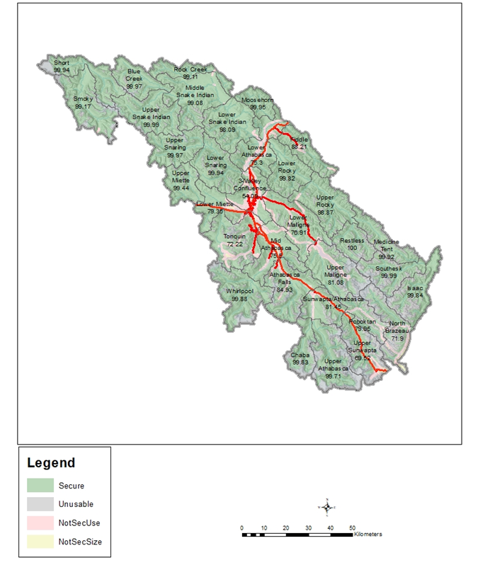
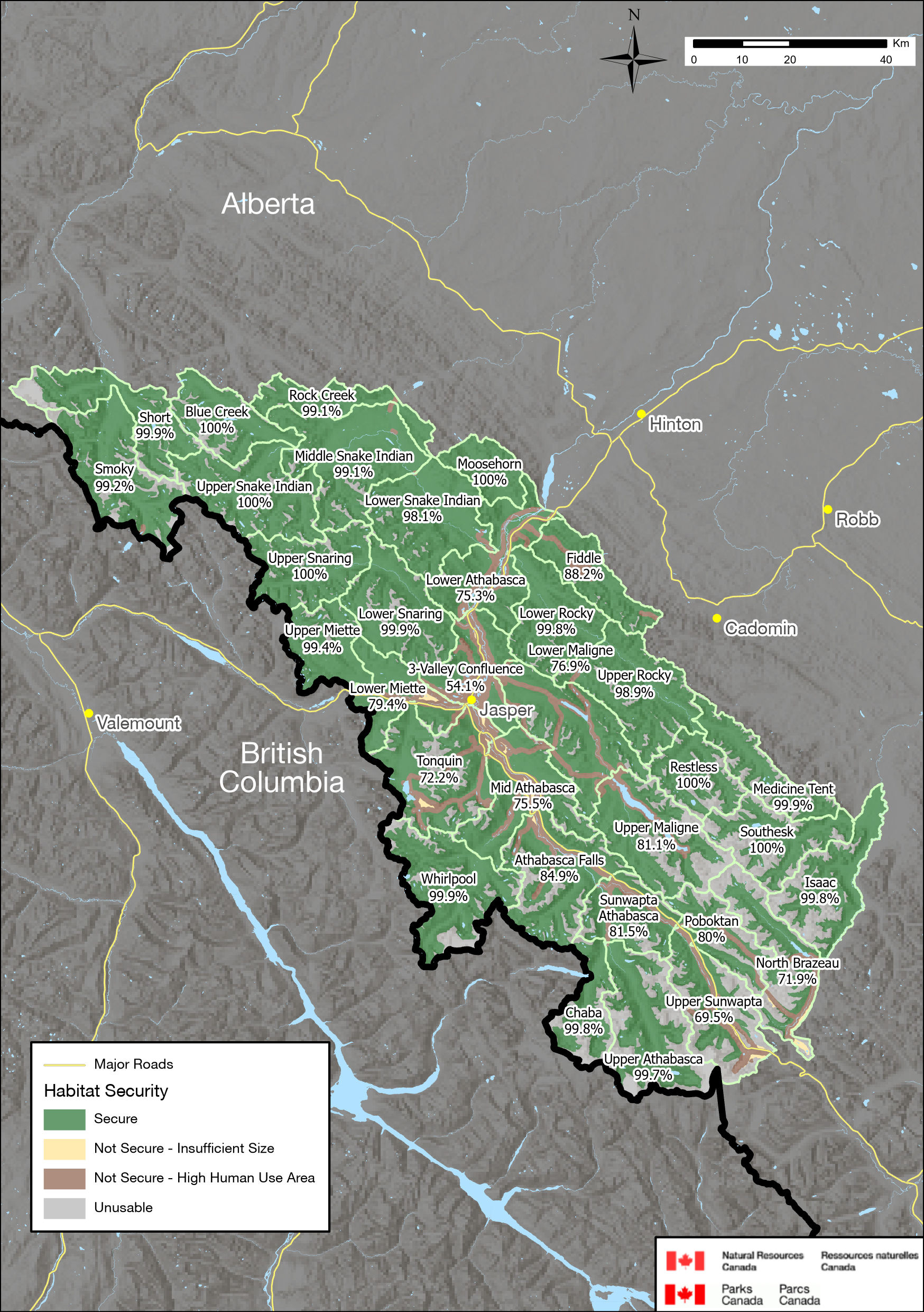
Text description
This map shows carnivore habitat security throughout Jasper National Park, by Landscape Management Unit in 2017.
The major roads and highways that run throughout the park are indicated with red lines.
A legend is located in the bottom left corner of the map, and a scale bar from 0 to 50 km in located in the bottom right.
The legend identifies 4 categories of habitat security: Secure (Green), Unusable (Grey), NotSec Use (Pink) and NotSecSize (Yellow).
The map shows the extent of Jasper National Park, divided into 33 Landscape Management Units of similar size. Each Landscape Management Unit is labelled with the percentage of secure habitat contained within it, as described in the table below (listed generally from north to south):
| Landscape Management Unit | Percentage of Secure Habitat |
|---|---|
| Short | 99.94 |
| Smoky | 99.17 |
| Blue Creek | 99.97 |
| Rock Creek | 99.11 |
| Upper Snake Indian | 99.99 |
| Middle Snake Indian | 99.08 |
| Lower Snake Indian | 98.09 |
| Moosehorn | 99.95 |
| Upper Snaring | 99.97 |
| Lower Snaring | 99.94 |
| Upper Miette | 99.44 |
| Lower Miette | 79.35 |
| 3-Valley Confluence | 54.09 |
| Lower Athabasca | 75.3 |
| Fiddle | 88.21 |
| Lower Rocky | 99.82 |
| Upper Rocky | 98.87 |
| Lower Maligne | 76.91 |
| Upper Maligne | 81.08 |
| Mid Athabasca | 75.5 |
| Tonquin | 72.22 |
| Whirlpool | 99.88 |
| Athabasca Falls | 84.93 |
| Sunwapta/Athabasca | 81.45 |
| Restless | 100 |
| Medicine Tent | 99.92 |
| Southesk | 99.99 |
| Isaac | 99.84 |
| North Brazeau | 71.9 |
| Poboktan | 79.95 |
| Upper Athabasca | 99.71 |
| Chaba | 99.83 |
Analysis
Visitation in the mountain national parks is anticipated to continue to increase over the next 10 years. Increased visitation will likely correspond to an increase in human activity on trails. The grizzly bear habitat model incorporates visitor use in an area; if there are more than 100 users on a trail in a month, the trail is considered unsecure. Backcountry visitor use data are derived from remote cameras in select locations, backcountry camping permits, Alpine Club of Canada data, backcountry lodge data, and the expert opinion of Parks Canada Resource Conservation and Visitor Experience specialists. While these sources of information are valuable, they may underestimate visitor use in some areas with high numbers of visitors out for day trips.
Other potential future pressures on habitat security include increased visitor access and development within the park. The Great Divide Trail is a wilderness trail that follows the continental divide between Alberta and British Columbia, from Waterton Lakes National Park to Kakwa Provincial Park north of Jasper in British Columbia. The route follows official and unofficial trails and has become increasingly popular in recent years. The route enters Jasper National Park from Banff National Park at Cataract Pass, and then follows a series of official and unofficial trails along the entire length of Jasper, briefly crossing into Mount Robson Provincial Park, before exiting Jasper at Bess Pass. Increasing use on this trail through wilderness areas has the potential to impact habitat security in parts of the Park that otherwise do not see human use.
There is currently no summer offer at Marmot Basin ski hill, and a locked gate prohibits motorized access during the summer months, which helps maintain habitat security in this LMU; however, the Jasper SkyTram provides easy summer access to the alpine. The SkyTram is operational from March to October, and there are currently no limits on visitor numbers, although they are limited by the capacity of their physical infrastructure.
Overall through the Park, visitor numbers have increased over the past 10 years, while habitat security has not declined. The good and stable multi-species mammal occupancy result suggests that maintaining or improving habitat security has been positive for grizzly bears.
While the trends and status of habitat security have been positive, other issues in the future will require consideration. Detection rates of grizzly bears, wolves and wolverine are correlated with the number of people per day on the trails (Parks Canada Agency 2018a). Of all the species analyzed, wolverine have the strongest negative response to human activity — 95% of wolverine detections occurred when there were one or fewer people events per day (Parks Canada Agency 2018a). No wolverines were detected when there were more than 14 events (39 people) per day (Parks Canada Agency 2018a). Lynx show avoidance of areas when there are around 100 people per day detected on trails (Parks Canada Agency 2018a). As a result, small increases in use in areas with very low use may be important for wolverine.
Industrial land use and roads, primarily used for oil and gas, mining or forestry activities, occur on provincial land outside of Jasper. They are often not fully decommissioned and may impact carnivore habitat security and habitat quality. Use of the roads for recreational access may have sensory impacts in the Park, which may reduce habitat security within Jasper. They also provide opportunities for facilitated recreational access to areas of Jasper that were previously challenging to reach. This may be an issue at Bess Pass on the border with British Columbia (Shepherd, pers. comm. 2019), and on Jasper's east border as former mine lands are reclaimed and re-opened for recreational access.
Climate change is anticipated to increase the average temperatures in Jasper (Parker 2017; Parker 2019). Precipitation patterns are also likely to change, as is plant diversity (Parker 2019). Altered hydrology regimes and shifting vegetation communities are likely to result in altered habitat conditions, and it is anticipated that wildlife will shift their distribution in response (Weaver 2013; Gomez-Ruiz and Lacher 2019; Zhao et al. 2019).
It is probable that the timing and quality of grizzly bear forage habitat will be affected by climate change (Deacy et al. 2017; Laskin et al. 2019). Grizzly bears have been found to select for burned patches within their home ranges, particularly from August to September as they eat to fatten for hibernation (Hunt 2018). Wildfire season is expected to increase by up to 40 days a year in Jasper (see section 4.1), and as a result of the habitat selection for burn patches, this increase in wildfire on the landscape could alter the amount of available habitat.
Mitigations
| Desired Outcomes |
The management plan outlines the following desired outcomes for habitat security:
|
| Strategic Mitigations | The management plan commits Parks Canada to achieving the following targets. Achieving the results outlined in these targets will mitigate potential cumulative effects on habitat security:
|
| Project-Level Mitigations | This strategic environmental assessment identified the following additional mitigations, which Parks Canada will apply through the impact assessment of individual projects, to mitigate the potential impacts of projects on habitat security:
|
Conclusion
Increases in visitation and climate change may contribute to cumulative effects impacting carnivore habitat security if increased visitation takes place in currently secure habitats. The management plan provides direction for the implementation of visitor use management strategies and tools, which will help ensure habitat security is maintained in the Park. With grizzly bear habitat security considered in the impact assessment of all projects, habitat security will be maintained as demonstrated in the last 10 years. Therefore, the implementation of the management plan is expected to maintain carnivore habitat security in Jasper National Park.
| Confidence Level | Rationale | |
|---|---|---|
| Quality of information sources on valued component | High | Good information collected over an appropriate time frame and whole applicable area of park |
| Quality of information sources on sources of impacts | Medium | Recent trends in visitation are variable, and limited data on visitor use within the Park is available. |
| Understanding of pathways of effects | High | Good understanding of pathways of effects |
| Analysis of VC | High | Analysis of VC based on quantitative or studies from multiple peer-reviewed literature sources, with good correspondence to project-VC interaction, and site-specific baseline or follow-up studies adhering to accepted scientific methodologies |
6.12 Woodland caribou – southern mountain population
Current status
Woodland caribou, southern mountain population (Rangifer tarandus caribou) are federally listed as Threatened under Schedule 1 of SARA. In 2018, the Minister of Environment and Climate Change determined that caribou are facing imminent threats to recovery and that the Jasper/Banff Local Population Unit (LPU) was identified in the assessment to be under imminent threat of extirpation (ECCC 2018).
Two LPUs are present in Jasper, the Jasper/Banff and the À La Pêche. The Tonquin, Maligne, and Brazeau herds are all part of the Jasper/Banff LPU, while the À La Pêche herd is transboundary, and responsibility for the herd is shared with the Government of Alberta.
The next paragraphs describe the status of each caribou herd, caribou predator/prey dynamics, and the status of caribou habitat around the Park.
Caribou in Jasper (Jasper/Banff and À la Pêche LPUs combined) are rated as poor and declining (Parks Canada Agency 2018a). The Jasper/Banff LPU is at risk of being completely extirpated within the life of the next management plan (i.e., within the next 10 years). The Maligne herd is now considered to be extirpated. The Brazeau herd has fewer than 15 individuals, and the Tonquin herd has an estimated 31 individuals (Parks Canada Agency 2020) (Figure 10). Both remaining herds are at or below the quasi-extinction threshold and at a level that is unlikely to recover without additional measures. Approximately 150 individuals are estimated in the À La Pêche herd (Manseau, pers. comm. 2019). Only the À La Pêche herd has increased over the last decade, which is attributed to predator control measures conducted by the Government of Alberta on provincial lands (Parks Canada Agency 2018a).
Caribou populations are sensitive to changes in predator/prey dynamics wherein increases in preferred prey availability/abundance positively affect predator density, which in turn can rapidly diminish caribou populations. This phenomenon is known as apparent competition, where two prey animals share a common predator that has a disproportionate effect on the less numerous prey species as a result of high abundance in the preferred prey species. Two wildlife management decisions in Jasper resulted in long-term caribou decline and have led to management-induced apparent competition in Jasper (Bradley and Neufeld 2012). Elk were reintroduced to Jasper in 1920. To support their reintroduction, wolves and other predators were killed from 1920 to 1959 (Bisaillon and Neufeld 2019). Once predator control stopped, wolves profited from very high elk densities, and their numbers increased substantially, which resulted in more caribou being preyed upon (Bisaillon and Neufeld 2019). Until 2006, Parks Canada also disposed of road-killed carcasses into wolf-accessible gravel pits, which further supported wolf populations. The effects of these decisions continue to impact caribou in the Park.
Given the established relationship between high elk densities and detrimental impacts on caribou, monitoring elk abundance and distribution provides additional insight into ecological conditions for caribou. Elk abundance in Jasper is rated good and stable in the Ecological Integrity Monitoring Program, which means that while elk still persist on the landscape, they have declined significantly and no longer support an unnaturally high wolf population.
Regional motorized access density is used to determine what regional disturbances affect ecological processes within Jasper. For caribou, access density is rated as poor and declining in the Ecological Integrity Monitoring Program. Generally, Jasper's Ecological Integrity Monitoring Program found that the condition of caribou ranges that overlapped with Jasper were rated as being in good condition, whereas ranges that fell mostly outside of protected areas were in fair or poor condition (Parks Canada Agency 2018a). This means that working with regional land managers is important for the transboundary À La Pêche herd.
Text description
| Population Estimates and Minimum Counts in South Jasper National Park 2003 to 2019 | |||||||||||||||||
|---|---|---|---|---|---|---|---|---|---|---|---|---|---|---|---|---|---|
| Year | 2003 | 2004 | 2005 | 2006 | 2007 | 2008 | 2009 | 2010 | 2011 | 2012 | 2013 | 2014 | 2015 | 2016 | 2017 | 2018 | 2019 |
| Brazeau Count | 16 | 22 | 24 | 18 | 20 | 13 | 9 | 8 | 11 | 12 | 8 | 9 | 12 | 7 | 8 | 10 | 8 |
| Maligne Count | 24 | 11 | 8 | 8 | 5 | 6 | 4 | 6 | 6 | 6 | 5 | 2 | 3 | 3 | 3 | 0 | 0 |
| Tonquin Visual Estimate | 43 | 38 | -- | 111 | 73 | 115 | 74 | 61 | 54 | -- | 38 | 33 | -- | -- | -- | -- | -- |
| Tonquin Scat Estimate | -- | -- | -- | 90 | 78 | 87 | 75 | 59 | 50 | 39 | 43 | 34 | 26 | 34 | 26 | 31 | -- |
| Tonquin MinAlive | 43 | 27 | 65 | 89 | 63 | 94 | 74 | 58 | 47 | -- | 38 | 29 | 25 | 22 | 18 | 27 | 24 |
Analysis
Following the direction provided by the Recovery Strategy for the Woodland Caribou, Southern Mountain population (Rangifer tarandus caribou) in Canada (Environment Canada 2014), critical habitat has been identified in Jasper. Further details on critical habitat including activities that are likely to result in its destruction are available in the recovery strategy (Environment Canada 2014). The national population and distribution objective for caribou is to achieve self-sustaining populations in all LPUs within their current distribution by:
- Stopping the decline in both size and distribution of all LPUs;
- Maintaining the current distribution within each LPU; and
- Increasing the size of all LPUs to self-sustaining levels and, where appropriate and attainable, to levels that can sustain a harvest with dedicated or priority access to Indigenous peoples.
The site-based population and distribution objectives for the Jasper/Banff LPU are to achieve stable to increasing numbers to a minimum of 100 animals as a step toward achieving self-sustaining local herds in which natural processes (dispersal, migration) can occur. Where caribou have been extirpated, opportunities for restoration will be examined (Parks Canada Agency 2017). The caribou herds in Jasper are at or below the quasi-extinction threshold and will not recover naturally without intervention (Bisaillon and Neufeld 2019; Hebblewhite 2017; Johnson 2017; Neufeld and Bisaillon 2017; Schmiegelow 2017).
There are five primary threats to southern mountain caribou in Jasper, as identified by the Parks Canada Mountain Park Caribou Conservation Committee (2011) and Bisaillon and Neufeld (2019): (1) Small population effects, (2) Altered predator/prey dynamics, (3) Direct disturbance, (4) Facilitated predator access, and (5) Elimination of caribou habitat.
- Small population effects — Small wildlife populations are subject to inbreeding and are less resilient to demographic fluctuations and anomalies, random and catastrophic events, and disease (Lacy 2000). Caribou populations in Jasper are so small that they will not recover on their own without intervention (Bisaillon and Neufeld 2019). The other threats outlined below are also exacerbated due to the small population effects. This is now the main threat that the Jasper/Banff LPU is facing.
- Altered predator/prey dynamics — Human activities can indirectly increase the number of caribou predators (wolves or bears), usually through increases in other prey (elk, deer or moose) (Environment Canada 2014). Historical management decisions that altered the predator/prey dynamic as described above continue to have an impact on caribou in Jasper. These internal dynamics are added to by habitat alteration adjacent to park boundaries that has resulted in increase of alternative prey species, and increased wolf populations above historical levels (Bisaillon and Neufeld 2019). This impact may carry over within park boundaries. Natural disturbances such as mountain pine beetle and wildfire, and management activities such as prescribed burns and FireSmart activities convert mature forests into young open forest stands favoured by alternative prey species. As a forest regrows post fire, the vegetation favours ungulates such as deer and elk, and therefore may contribute to a shift in predator/prey dynamics (Smith 2000). Climate change is anticipated to increase the frequency of large stand-replacing fires, in addition to increasing the prevalence of forest insect and disease, such as mountain pine beetle (Parker 2019). Wolf density in southern Jasper has been below the 3 wolves per 1,000 km² threshold since 2013 (Figure 11). Maintaining wolf density below this threshold is important for caribou to persist on the landscape (Environment Canada 2014; Neufeld and Bisaillon 2017; Bisaillon and Neufeld 2019).
Text description
| Year | 2003 | 2004 | 2005 | 2006 | 2007 | 2008 | 2009 | 2010 | 2011 | 2012 | 2013 | 2014 | 2015 | 2016 | 2017 | 2018 |
|---|---|---|---|---|---|---|---|---|---|---|---|---|---|---|---|---|
| Density of Wolves (per 1000km2) in South Jasper | 6.2 | 6.2 | 5.9 | 3.4 | 3.2 | 2.8 | 3.4 | 3.6 | 3.4 | 3.3 | 1.9 | 2.1 | 2.5 | 1.8 | 1.5 | 1.8 |
- Direct disturbance — Skiing, snowshoeing and hiking may disturb caribou through displacement and increased stress, although this is not likely a major factor for caribou in Jasper that may experience higher levels of habituation. General avoidance of areas within approximately 5 km of Marmot Basin ski hill by caribou is attributed to human activities (Czetwertynski and Schmiegelow 2014). Marmot Basin ski hill uses explosives to reduce the likelihood of avalanches, and this expands the displacement of caribou beyond its lease boundaries. While infrequent, observations of caribou at Marmot Basin are known to occur. Marmot Basin has no formal policy or guidance on how to mitigate impacts to caribou when they are observed on the ski hill.
Recreational ATV and snowmobile use is high beyond park boundaries, and it may impact the À la Pêche transboundary herd. Displacement due to these activities may result in caribou moving to areas where mortality risks are higher, and increased stress may result in poor body condition, and lower survival and reproductive rates (Environment Canada 2014). While motorized activities are permitted in the Park for operational and some commercial purposes, it is generally low and regulated so it is not likely an important factor for the Brazeau or Tonquin herds. Aircraft (fixed or rotary wings) are used in Jasper for park management purposes and may present a risk to caribou during critical times of the year. Guidelines are in place to minimize impact associated with flights.
Vehicle strikes have not been a major source of caribou mortality in Jasper in recent years, although that may be attributed to the extremely low caribou densities. The highway and parkway that go through Jasper are not fenced and do not have wildlife overpasses.
- Facilitated predator access — This refers to activities that pack winter trails or clear roads of snow in caribou habitat, reducing the effort it takes for predators to reach caribou (Parks Canada Mountain Park Caribou Conservation Committee 2011). These activities may occur in the Park through visitor use and operational purposes, or on lands adjacent to the park. Snowshoeing and backcountry skiing are popular in Jasper, and users establish packed winter trails which facilitate predator movement. As of 2021, winter access restrictions are being imposed in the Brazeau, Tonquin, and North Jasper areas to prohibit recreationalists from accessing caribou habitat in the winter. This prevents users from establishing packed winter trails into caribou habitat, mitigating the risk of facilitated predator access.
- Elimination of caribou habitat — Elimination of caribou habitat includes two main threats:
- Industry/development that causes the loss of high-quality habitat — Transboundary caribou populations in Jasper are affected by activities beyond park boundaries, including habitat alteration due to industrial activities such as mining and forestry. Jasper monitors this through the regional motorized access density Ecological Integrity Monitoring Program..
- Climate change — The potential effects of climate change on southern mountain caribou are not well understood. However, it will likely exacerbate threats currently facing southern mountain caribou and will contribute to the destruction or degradation of some critical habitat (McNay et al. 2006; Post and Forchhammer 2008; Environment Canada 2014).
In Jasper National Park, caribou are not likely habitat limited, and direct habitat loss alone is not a key aspect influencing conservation efforts in the park. However, habitat changes may alter predator/prey dynamics through increased apparent competition, as described above.
Mitigations
| Desired Outcomes | The management plan outlines the following desired outcomes for caribou:
|
| Strategic Mitigations | The management plan commits Parks Canada to achieving the following targets. Achieving the results outlined in these targets will mitigate potential adverse cumulative effects on caribou:
|
| Project-Level Mitigations | This strategic environmental assessment identified the following additional mitigations, which Parks Canada will apply through the impact assessment of individual projects, to mitigate potential adverse project impacts on caribou:
|
Due to the small population size of the Jasper/Banff LPU, the herds are at risk of being extirpated within the life of the management plan. Implementing the above mitigations are not expected to be able to successfully reverse caribou decline. Working with partners and experts, Parks Canada has drafted a preliminary project proposal to rebuild caribou herds in Jasper National Park through a conservation breeding and herd augmentation program. Parks Canada is currently assessing how suitable this approach is and what it would take to be successful. This includes planning for and implementing consultations with Indigenous partners, the public, and stakeholders, evaluating scientific evidence, determining source and recipient herds, exploring potential facility sites and developing a facility design, developing animal health protocols and requirements for caribou raising, and identifying the costs of a program and resources needed. The potential caribou breeding and herd augmentation program would involve creating a breeding facility in caribou habitat in the Park, capturing wild caribou, and rearing calves to increase their rate of survival. Such a program is challenging given caribou biology and ecology, and as a result, intervention in the form of a conservation breeding program is not certain to result in recovery. In addition, such a program would involve substantial costs and many years to implement. However, this may be the best way to address the threat of a small population and increase the probability of herd recovery (Parks Canada Agency 2020b) and without implementing such a program, in all likelihood, the Jasper/Banff LPU will not survive.
Conclusion
Regional activities, visitation, predation, and climate change all contribute to cumulative effects experienced by caribou. The management plan commits to addressing the main threats to caribou within Jasper National Park within the jurisdiction of Parks Canada. The implementation of the management plan will not cause important negative effects to caribou.
| Confidence Level | Rationale | |
|---|---|---|
| Quality of information sources on valued component | High | Good information collected over an appropriate time frame and whole applicable area of park |
| Quality of information sources on sources of impacts | Medium | Open land use around the Park and high number of different types of developments are possible. |
| Understanding of pathways of effects | Medium | Moderate understanding of pathways of effects |
| Analysis of VC | High | Analysis of VC based on quantitative or studies from multiple peer-reviewed literature sources, with good correspondence to project-VC interaction and on site-specific baseline or follow-up studies adhering to accepted scientific methodologies |
6.13 Mountain goats
Mountain goats (Oreamnos americanus) are found throughout the mountain national parks in locally abundant populations. In Alberta, mountain goats live in the mountains from Waterton Lakes National Park in the south to Willmore Wilderness Park north of Hinton (Alberta mountain goat management plan, 2003). The Alberta population estimate on provincial lands is 1,963 and in the national parks is 1,430 for a total of 3,393 (Smith and Hobson 2008).
Mountain goats are associated with rough, rocky cliffs and ledges where they can escape danger. Mountain goats are considered vulnerable to cumulative effects due to their narrow habitat preferences, low reproductive potential, and sensitivity to a variety of disturbance types (Weaver 2013). The extent of these impacts on goats appears to be variable between populations.
Current status
Mountain goats are not part of the Ecological Integrity Monitoring Program in Jasper because of their niche as habitat specialists having limited and specific ranges, and the difficulties to conduct accurate long-term surveys at the park scale. Parks Canada has identified 25 distinct mountain goat ranges in Jasper. There is no reliable population estimate for mountain goats in Jasper.
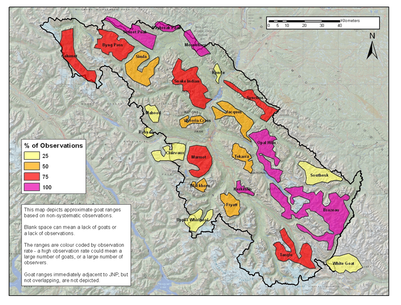
Text description
This map shows the approximate ranges of mountain goats within Jasper National Park, based on historical observations.
The boundary of Jasper National Park is delineated by a black line.
The map includes a scale bar from 0 to 40 kilometres, and a north arrow pointing up, in the top right corner.
A legend is located on the left side of the map, indicating 4 categories of mountain goat ranges, colour coded according to percentage of observations.
Ranges with a 25% observation rate are shown in light yellow.
Ranges with a 50% observation rate are shown in orange.
Ranges with a 75% observation rate are shown in red.
Ranges with a 100% observation rate are shown in purple.
A description of the map is contained within a text box underneath. The text box reads: "This map depicts approximate goat ranges based on non-systematic observations. Blank space can mean a lack of goats or a lack of observations. The ranges are colour coded by observation rate – a high observation rate could mean a large number of goats, or a large number of observers. Goat ranges immediately adjacent to Jasper National Park, but not overlapping, are not depicted".
The map indicates 25 distinct ranges contained within and overlapping the boundary of Jasper National Park.
Ranges with a 25% observation rate include: Ronde, Mahood, Robson, Clairvaux, Upper Whirlpool, Southesk and White Goat.
Ranges with a 50% observation rate include: Simla, Vistoria Cross, Jacques, Tekarra, Blackhorn and Fryatt.
Ranges with a 75% observation rate include: Calumet, Byng Pass, Snake Indian, Syncline, Marmot and Tangle.
Ranges with a 100% observation rate include: Sunset Peak, Daybreak Peak, Moosehorn, Opal Hills, Kerkeslin and Brazeau.
The areas where high levels of human use intersect with mountain goat habitat in Jasper are:
- Marmot Basin ski hill;
- Roadside salt licks at Disaster Point (Highway 16), the Goat Lick (Icefields Parkway), and the Sunwapta Canyon/Columbia Icefield SkyWalk viewpoint on Tangle Hill (Icefields Parkway); and
- Jasper SkyTram.
Research on the status and habitat use of mountain goats in Jasper has been largely limited to the area around Marmot Basin ski hill (e.g., Richard et al. 2014; Richard and Côté 2016), and to the environmental assessment and monitoring program for the Columbia Icefield SkyWalk (Golder Associates 2011; Golder Associates 2012; Golder Associates 2014; Golder Associates 2017). In addition to observing spatial and temporal aspects of displacement, the Marmot Basin study found that Trident Range mountain goats are genetically diverse and different from mountain goats east of the Athabasca River. Also, two genetically different mountain goat groups, roughly separated by Whistlers Creek, share the Trident Range area, suggesting limited interaction between both groups (Richard et al. 2014). Monitoring of mountain goats associated with the Columbia Icefield SkyWalk viewpoint on Tangle Hill found use patterns and herd numbers to be stable during the 2011–2017 monitoring period, which observed pre-construction, construction and operation phases (Golder Associates 2011; Golder Associates 2012; Golder Associates 2014; Golder Associates 2017).
Regional trends may provide some inference on the status of goats in other parts of Jasper. Mountain goats have been monitored in Yoho and Kootenay national parks since 2015, but the monitoring strategy is still being developed, and their status remains uncertain in Yoho and Kootenay national parks (Parks Canada Agency 2019d, 2019e). Monitoring has been more extensive in the Lake Louise portion of Banff National Park, where they are assessed as fair and stable (Hunt 2018).
Mountain goats are subjected to harvest pressure in both British Columbia and Alberta. Following years of declines, the Government of Alberta closed the hunting season for mountain goats in 1988 (Smith and Hobson 2008). A limited hunt was re-established in 2001 in select Wildlife Management Units north of Jasper, and south of Kananaskis (Government of Alberta 2019b). To support wildlife management decisions in these areas, the Government of Alberta has been conducting aerial mountain goat surveys. Most recent estimates from 2016 in the Willmore indicate that mountain goat populations in that location continue to exhibit either declines or depressed populations, and only one of the five goat hunting areas in this region was opened in 2019 (Government of Alberta 2019b, 2019c). In areas south of Kananaskis and north of Waterton Lakes National Park, the total number of mountain goats observed in 2018 did not meet the minimum required to have a limited opportunity harvest (Government of Alberta 2019d).
Harvesting of goats is less restricted in British Columbia, and hunting of mountain goats is permitted in management units that are adjacent to Jasper (Government of British Columbia 2020). Goat surveys conducted in the Robson Valley west of Jasper indicate that populations have declined by approximately 50% between 1998 and 2017 (Klaczek 2018). Goat populations are thought to be decreasing in many of the areas adjacent to the mountain national parks (Poole 2015). The consistency in declines in population throughout the region suggests factors are impacting mountain goats on a regional scale, and populations in Jasper may also be affected; however, the long intervals between surveys make interpretation of results difficult (Poole 2015).
Analysis
Mountain goat populations may be impacted by (1) hunting outside the Park, (2) increases in predators, (3) climate change, (4) road mortality, and (5) disturbances.
- Hunting outside the Park — As mentioned above, hunting is permitted in both British Columbia and Alberta around Jasper National Park.
- Increases in predators — Increased populations of cougars through the 1990s and declines in the 2000s appear to be inversely linked to estimated mountain goat numbers (Poole 2006). Some evidence suggests cougar numbers in Alberta are increasing, which may influence mountain goat populations (Knopff et al. 2014).
- Climate change — Climate change is anticipated to constrain optimal habitat for mountain goats in a variety of ways. Subalpine habitats are anticipated to move upward, potentially shrinking the availability of alpine areas (Weaver 2013; Mountain Goat Management Team 2010). At the same time, intense summer heat may reduce available foraging times for mountain goats, which are not likely to have high heat tolerance (Weaver 2013). More rapidly melting snowpack in the spring may reveal fresh green forage all at once across multiple elevations, overwhelming the ability of goats to access forage at its highest quality over a longer period of time (Pettorelli et al. 2007). Greater variability in green-up due to more spring storms and the potential for increased ice-on-snow events may affect kid survival and health (Mountain Goat Management Team 2010; Côté and Festa-Bianchet 2001). Mountain goats have a more generalist feeding strategy when compared with other alpine wildlife species, which could reduce the impact of climate change on their survival (Mountain Goat Management Team 2010; Pojar 2009).
- Road mortality — Mountain goat mortality from vehicle collisions in Jasper is a rare event, despite the occurrence of natural mineral licks adjacent to Highway 16 and the Icefields Parkway, and goats' use of road salt and roadside mineral licks. Traffic along the Icefields Parkway has increased over the past 10 years. Traffic is greatest during the summer months when goats are alongside the highway. Mountain goats are generally considered to have poor potential to compensate for increased adult mortality of any kind (Mountain Goat Management Team 2010).
- Disturbances — A variety of disturbance types have been shown to impact mountain goat behaviour including mechanized industrial activities, human activity, and aircraft/helicopter traffic (Côté 1996; Goldstein et al. 2005; Festa-Bianchet and Côté 2008; Weaver 2013). These types of disturbances may cause goats to leave portions of historical ranges, resulting in the abandonment of optimal habitat, which could contribute to declines in local goat populations (Festa-Bianchet and Côté 2008). Current motorized use outside the Park is thought to be focused in areas of flatter terrain, away from key goat habitat and escape terrain. However, increasing motorized vehicle access and incidental human presence during summer and winter seasons may contribute added disturbance to transboundary mountain goat populations.
Helicopter use is recognized as a potential source of disturbance and displacement of mountain goats, and may result in direct mortality during escape attempts and abandonment of optimal habitat areas (Festa-Bianchet and Côté 2008). Within Jasper, Restricted Activity Permits are required for any aircraft landings –helicopter or fixed-wing -in the Park. Jasper primarily issues these permits for park operational purposes, with park-specific flight guidelines to protect against disturbance to wildlife, including mountain goats. Permits are also issued to recreational pilots using the Jasper Airstrip; the flight guidelines are made available to these users. The sensory impact of aerial disturbance on goats in the Park is limited. Looking ahead, operational use of helicopters is expected to remain relatively stable, but it may increase in conjunction with fire management activities if the fire season lengthens as expected with climate change projections.
Marmot Basin ski hill is located in known goat habitat, and goats have been observed at the site; however, they have been generally displaced from the area in both summer and winter months (Richard and Côté 2016). Goats were found to avoid the area in the summer when human activity was minimal suggesting that either the low level of summer use was sufficient to limit mountain goat use, or the high levels of winter use resulted in year-round displacement (Richard and Côté 2016).
Increased visitation in Jasper may result in more hiker interaction with mountain goats, subject to where visitors go, noting that visitation mainly occurs on day use trails and facilities rather than in mountain goat ranges. The peak visitation season (May to September) overlaps with the most productive season for vegetation. Disturbance to goats during this time may have negative overwinter survival implications; however, the extent of this impact is variable, and some populations of goats are more habituated and therefore less vulnerable (Mountain Goat Management Team 2010). An increase in visitation may also result in an increase in people hiking with dogs, including those that are non-compliant with off-leash dogs.
The impact of increases in visitation on mountain goats is difficult to predict. Mountain goats are already displaced to a large degree from concentrations of visitor use at the Jasper SkyTram and Marmot Basin ski area, and yet continue to use the slopes above and below the Columbia Icefield SkyWalk at Sunwapta Canyon, and are tolerant of concentrations of people at the Icefields Parkway Goat Lick. Increasing visitation and vehicle traffic may affect habitat use and security at roadside mineral licks and associated trails. Impacts on mountain goats associated with potential increases in backcountry use are expected to be minimal, with some site-specific potential for increased interactions on trails such as Wilcox Pass trail (high use but no longer a through trail) and Whistlers Creek (low use).
Mitigations
| Desired Outcomes | The management plan outlines the following desired outcomes for mountain goats:
|
| Strategic Mitigations | The management plan commits Parks Canada to achieving the following targets. Achieving the results outlined in these targets will mitigate potential negative cumulative effects on mountain goats.
|
| Project-Level Mitigations | This strategic environmental assessment identified the following additional mitigations, which Parks Canada will apply through the impact assessment of individual projects, to mitigate potential negative project impacts on mountain goats:
|
Conclusion:
The implementation of the new management plan is not expected to cause additional negative cumulative effects on mountain goats. Mitigation measures for mountain goats are best addressed through park operations and project-level impact assessments for future initiatives.
| Confidence Level | Rationale | |
|---|---|---|
| Quality of information sources on valued component | Low | Not part of monitoring program; limited to no baseline |
| Quality of information sources on sources of impacts | Medium | Recent trends in visitation are variable, and limited data on visitor use within the Park is available. Furthermore, there is open land use around the Park and a high number of different types of developments are possible. |
| Understanding of pathways of effects | Low | Limited understanding of pathways of effects |
| Analysis of VC | Medium | Analysis of VC based on precedent/past experience, non-site-specific scientific modelling data, quantitative studies from multiple peer-reviewed sources where the correspondence to project-VC interaction is less precise and qualitative studies |
7 Outstanding Universal Value
The Canadian Rocky Mountain Parks World Heritage Site, which includes Jasper, was designated in 1984. World Heritage Sites are designated to protect those parts of cultural and natural heritage that are of outstanding interest on a global scale and therefore need to be preserved as part of the world heritage of humanity as a whole. Upon designation, outstanding universal values (OUVs) are identified for each site. The OUVs for the Canadian Rocky Mountain Parks World Heritage Site are based on the following criteria:
"Criterion (vii): The seven parks of the Canadian Rockies form a striking mountain landscape. With rugged mountain peaks, icefields and glaciers, alpine meadows, lakes, waterfalls, extensive karst cave systems and deeply incised canyons, the Canadian Rocky Mountain Parks possess exceptional natural beauty, attracting millions of visitors annually.
Criterion (viii): Outstanding examples representing major stages of earth's history, including the record of life, significant ongoing geological processes in the development of landforms, or significant geomorphic or physiographic features."
7.1 Methods
To assess the impacts on the OUV of the World Heritage Site in Jasper, the following methodology was applied. First, the world heritage criteria statements that describe the OUVs in broad terms were broken into elements or components that are measurable and can be more easily evaluated. This was accomplished using a method developed by Jon Day that was employed for a similar evaluation of the Great Barrier Reef World Heritage Site.
Day refers to the world heritage values statements for properties as "somewhat high level and nebulous, or (managers) do not understand how it might assist or help to prioritize their planning and management efforts" (Day 2015). In order to make the world heritage statements more assessable, Day developed the following method:
- To "break the complex Statement of OUV into smaller more understandable components. This involved breaking down the full approved Statement text into smaller 'excerpts' for each of the natural criteria and integrity;" and
- Sequentially to:
- "Identify key examples of values or attributes against each Statement excerpt;"
- "Identify the factors affecting those values;"
- "Prioritize the highest priority threats;" and
- "Consider what are the priority management needs to address the highest priority threats" (Day 2015)
As described by Day, the advantages to this approach are that it "helps more readily identify the key values or attributes for their property and prioritize their management actions," "helps to directly link the property's values to management operations," "clarifies the research priorities for the property," and "ensures that the committees themselves are focusing on the world heritage values of the property when giving advice" (Day 2015). This methodology was used to break individual OUV criterion statements for the joint properties into constituent elements relevant to Jasper National Park.
Second, once the key elements were identified using the methods developed by Day (2015), the focus shifted to determining the desired outcome(s) for each element. Desired outcomes provide benchmarks against which impacts can be measured (Table 3). Finally, indicators or approaches to measuring if the desired outcomes were being achieved were identified (included in Table 3).
Key factors influencing the OUV components were identified. Similar to other valued components in the cumulative effects analysis, a 10-year scenario for climate change, external development, and park activities was considered, taking the key factors and the 10-year timescale into account. Mitigations were identified as necessary, and residual effects after mitigation were identified (Table 4).
Last, the overall strategic environmental asessment methods detailed above are applied to evaluate the potential impacts and strategic mitigations relevant to OUVs.
7.2 Interpretation of OUV
| Listing of Individual OUV Components for This Criterion | Interpreted Meaning | Desired Outcomes | Indicators and Current Condition and Trend |
|---|---|---|---|
| Criterion vii – Contain superlative natural phenomena or areas of exceptional natural beauty and aesthetic importance. | |||
| Rocky Mountain Parks WHS Criterion vii – | The seven parks of the Canadian Rockies form a striking mountain landscape. With rugged mountain peaks, icefields and glaciers, alpine meadows, lakes, waterfalls, extensive karst cave systems and deeply incised canyons, the Canadian Rocky Mountain Parks possess exceptional natural beauty, attracting millions of visitors annually. | ||
| A striking mountain landscape of exceptional natural beauty. | The combination of rugged mountain peaks, icefields and glaciers, alpine meadows, lakes, waterfalls, extensive karst cave systems and deeply incised canyons creates a landscape of high scenic value that attracts millions of visitors annually. A part of the world heritage value is the opportunity for millions of visitors to enjoy the natural beauty. Viewscapes beyond the park boundaries are uncommon; therefore, the exceptional natural beauty and viewscapes that need to be protected are within the parks, Natural beauty includes both the day and the night. Three parks are provincial. Altering landscapes for the purposes of public safety is not considered to be harming the natural beauty. |
An environment of exceptional natural beauty including rugged mountain peaks, icefields and glaciers, alpine meadows, lakes, waterfalls, extensive karst cave systems and deeply incised canyons is unimpaired. Natural beauty of the parks continues to attract millions of people, and evidence of infrastructure, the number of visitors and their activities do not detract from the natural beauty of the mountain parks. |
Desired Outcome 1
Desired Outcome 2
|
| Criterion viii – Outstanding examples representing major stages of earth's history, including the record of life, significant ongoing geological processes in the development of landforms, or significant geomorphic or physiographic features. | |||
| Rocky Mountain Parks WHS Criterion viii – | The Burgess Shale is one of the most significant fossil areas in the world. Exquisitely preserved fossils record a diverse, abundant marine community dominated by soft-bodied organisms. Originating soon after the rapid unfolding of animal life about 540 million years ago, the Burgess Shale fossils provide key evidence of the history and early evolution of most animal groups known today, and yield a more complete view of life in the sea than any other site for that time period. The seven parks of the Canadian Rockies are a classic representation of significant and ongoing glacial processes along the continental divide on highly faulted, folded and uplifted sedimentary rocks. | ||
|
Not applicable. |
|
|
7.3 Summary of results
Listing of Individual OUV Components |
Direction of Potential Impacts Over the Next 10 Years | Mitigations | Residual Impacts After Mitigation | ||
|---|---|---|---|---|---|
| Climate Change | External Development | Park Activities and Increased Visitation |
|||
| Rugged mountain peaks | No impact | No impact | No impact | No mitigations needed | Not applicable |
| Icefields and glaciers | Increased pressure, see detailed assessment in section 6.1 | No impact, see detailed assessment in section 6.1 | No impact, see detailed assessment in section 6.1 | None identified | Residual impacts are not expected from proposed plan. Climate change is expected to continue to adversely affect glaciers. |
| Alpine meadows | Increased pressure, see detailed assessment in section 6.8 | No impact, see detailed assessment in section 6.8 | Increased pressure, see detailed assessment in section 6.8 | See mitigations identified in section 6.8 | With implementation of mitigations, residual impacts are not expected from proposed plan. Climate change may cause shifts in alpine extent and species composition. |
| Lakes | Increased pressure, see detailed assessment in sections 6.2, 6.3 and 6.4 | No impact, see detailed assessment in sections 6.2, 6.3 and 6.4 | Increased pressure, see detailed assessment in sections 6.2, 6.3 and 6.4 | See mitigations identified in sections 6.2, 6.3 and 6.4 | With implementation of mitigations, residual impacts are not expected from proposed plan. |
| Waterfalls | No impact | No impact | No impact | No mitigations needed | Not applicable |
| Karst cave systems | No impact | No impact | No impact | No mitigations needed | Not applicable |
| Deeply incised canyons | No impact | No impact | No impact | No mitigations needed | Not applicable |
| Glacial processes (other than glaciers) | No impact | No impact | No impact | No mitigations needed | Not applicable |
| Natural beauty of the parks continues to attract millions of people | No impact | No impact | Positive impact | No mitigations needed | With implementation of mitigations, residual impacts are not expected from proposed plan as millions of people are still expected to be able to appreciate the beauty of the Park. |
Climate change is anticipated to have significant impacts on some OUV components. Glacial processes will alter and landscape-level shifts that are already being observed are expected to continue. Detailed analyses and mitigations are outlined above.
Certain aspects of the interpreted OUV components designated under Criterion vii that are related to the scenic beauty and striking topographic relief of the region have minimal potential to be impacted locally. The continued implementation of the Redevelopment Guidelines for Outlying Commercial Accommodations, the Town of Jasper Land Use Policy, and the Architectural Motif for the Town of Jasper will help to maintain an architectural motif and sightlines that will not detract from the natural beauty of the mountain landscape. Personal and non-personal interpretation activities can highlight the geomorphological processes underlying the unique topography of the region and highlight the changing glacial landforms.
Climate change will continue to affect icefields, glaciers, and plant and wildlife species. Continued monitoring and active restoration projects within the Park will help to maintain adequate unimpaired habitat and ecosystem processes necessary to maintain characteristic plant and wildlife communities and facilitate adaptation for species affected by changing environmental conditions under climate change scenarios.
Close working relationships with regional partners, including with provincial parks, along with other strong collaborative initiatives with local partners will facilitate working beyond borders for conservation gains within the Park and at a regional scale to better manage transboundary valued ecological components and stressors.
Although climate change is anticipated to have significant impacts on portions of Jasper's OUV, the vast majority of OUV components will stay intact. Jasper will remain an environment of exceptional natural beauty. Rugged mountain peaks, karst cave systems, and deeply incised canyons will remain unaffected by climate change. Even elements of OUV components that will be affected by climate change will continue to persist in the Park for a very long time. There are no residual impacts predicted on the OUV as a result of the proposed management plan.
8 Federal Sustainable Development Strategy
The 2016 Federal Sustainable Development Strategy (FSDS) is the Government of Canada's primary vehicle for sustainable development planning and reporting (Government of Canada 2016). It sets out the government's sustainable development priorities, establishes goals and targets, and identifies actions to achieve them. The proposed management plan, implemented in conjunction with the recommendations within this strategic environmental assessment report, is anticipated to have a positive result on themes III (Protecting Nature) and IV (Shrinking the Environmental Footprint). Many of the objectives support the goals of wildlife conservation and ecosystem/habitat conservation and protection (FSDS goals 5 and 6), while recommendations to use green procurement and smart technology for new infrastructure investments will help to further the FSDS goal 8 on greening government operations.
In the management plan, Parks Canada also commits to seeking to understand the impacts of climate change (Objective 6.1) and to sharing this knowledge with visitors and Canadians.
9 Conclusions
The strategic environmental assessment (SEA) focused on cumulative effects. It reviewed the potential cumulative effects from climate change, increased visitation, development activities around the Park, park proposals, and the proposed management plan on various valued components including glaciers, hydrology, water quality, aquatic communities, wetlands, forest vegetation, montane grasslands and dunes, alpine habitat, whitebark pine, terrestrial birds, carnivores, woodland caribou, mountain goats and species at risk.
The SEA also considered the Outstanding Universal Value criteria for which the Canadian Rocky Mountain Parks was inscribed as a UNESCO World Heritage Site to ensure these are adequately protected by the management plan.
Indigenous partners, the public, and stakeholders were consulted on the draft management plan. Feedback was considered and incorporated into the SEA and management plan as appropriate.
The SEA found that there will be positive impacts and no important negative environmental effects that are within the control of Parks Canada in Jasper National Park from the implementation of the management plan.
10 References
10 References
Alberta Biodiversity Monitoring Institute. 2019. Human Footprint Inventory data layers. Accessed September 2019. https://abmi.ca/home/data-analytics/da-top/da-product-overview/Human-Footprint-Products/HF-inventory.html
Andison, D., Van Damme, L., Hebert, D., Moore, T., Bonar, R., Boutin, S., and Donnelly, M. 2009. The Healthy Landscape Approach to Land Management. Foothills Research Institute, Hinton, Alberta, Canada.
Apps, C. 2020. Wary-Carnivore Functional Habitat Connectivity Cumulative Impact Assessment in and Around Mountain National Parks in Canada. For Natural Resource Conservation Branch, Parks Canada Agency.
Bennet, A.F. 2002. Linkages in the Landscape: The Role of Corridors and Connectivity in Wildlife Conservation. Second Edition. International Union for the Conservation of Nature.
Bisaillon, J.-F. and Neufeld, L. 2019. Conservation Breeding and Augmentation Strategy to Address Small Caribou Populations in Jasper National Park. Preliminary Project Proposal. Jasper National Park. Parks Canada Agency.
Boulanger, J., Bradley, M., and Stenhouse, G.B. 2016. Estimates of Population Size and Density of Black Bears from the 2014 South Jasper National Park DNA Mark-Recapture Inventory. Parks Canada Agency Report: 22 pp.
Bradley, M. 2020. Personal communication with Alexandra Taylor, Impact Assessment Specialist, Natural Resource Conservation Branch, Parks Canada Agency.
Bradley, M. and Neufeld, L. 2012. Climate and management interact to explain the decline of woodland caribou (Rangifer tarandus caribou) in Jasper National Park. Rangifer 32: 183-191.
Brett, R. 2017. 2017 Forest Health Conditions in the Rocky Mountain National Parks. Canadian Forest Service, Northern Forestry Centre, Edmonton, Alberta.
Brett, R. 2019. 2019 Jasper MPB Spring Population Assessment. Canadian Forest Service, Northern Forestry Centre, Edmonton, Alberta.
Callaway, R.M. 1998. Competition and facilitation on elevation gradients in subalpine forests of the northern Rocky Mountains, USA. Oikos: 561-573.
Campbell, E.M. and Antos, J.A. 2000. Distribution and severity of white pine blister rust and mountain pine beetle on whitebark pine in British Columbia. Can. J. For. Res. 30: 1051-1059.
Côté, S.D. 1996. Mountain goat responses to helicopter disturbance. Wildlife Society Bulletin 24: 681-685.
Côté, S.D. and Festa-Bianchet, M. 2001. Birthdate, mass and survival in mountain goat kids: effects of maternal characteristics and forage quality. Oecologia 127: 230-238.
Czetwertynski, S. and Schmiegelow, F. 2014. Tonquin Caribou Risk Assessment. Final report.
Day, J. 2015. Understanding Your Outstanding Universal Values (OUVs): How to break down OUVs to more effectively manage and report on your World Heritage Site. ARC Centre of Excellence for Coral Reef Studies. James Cook University, Townsville, Australia. Presented to the World Heritage Committee WHC39, Bonn. Saturday, July 4th, 2015. Retrieved from http://www.39whcbonn2015.de/fileadmin/media/Dateien/OUV_talk_WHC39_JCD_040715.pdf
Deacy, W.W., Armstrong, J.B., Leacock, W.B., Robbins, C.T., Gustine, D.D., Ward, E.J., Erlenbach, J.A., and Stanford, J.A. 2017. Phenological synchronization disrupts trophic interactions between Kodiak brown bears and salmon. PNAS 114: 10432-10437.
Derksen, C. and Brown, R. 2012. Spring snow cover extent reductions in the 2008-2012 period exceeding climate model projections. Geophysical Research Letters 39: L19504. doi:10.1029/2012gl053387
Eastern Slopes Rangeland Seeds Ltd. 2010. Non-native Plant Roadside Survey, Jasper National Park.
Environment and Climate Change Canada (ECCC). 2017. Recovery Strategy for the Whitebark Pine (Pinus albicaulis) in Canada [Proposed]. Species at Risk Act Recovery Strategy Series. Environment and Climate Change Canada, Ottawa. viii + 54 pp.
Environment and Climate Change Canada (ECCC). 2018. Imminent Threat Assessment for Southern Mountain Caribou.
Environment Canada. 2014. Recovery Strategy for the Woodland Caribou, Southern Mountain population (Rangifer tarandus caribou) in Canada [Proposed]. Species at Risk Act Recovery Strategy Series. Environment Canada, Ottawa. viii + 68 pp.
Environmental Sciences Group. 2019. Stormwater Monitoring Plan Development for the Town of Jasper, Alberta. Interim Report–Parameters of Interest February 2019. Prepared by Environmental Sciences Group, Royal Military College, Kingston, Ontario on behalf of Parks Canada Agency.
Farnes, P.E. 1990. SNOTEL and Snow Course Data: Describing the Hydrology of Whitebark Pine Ecosystems. General technical report INT (USA).
Festa-Bianchet, M. and Côté, S. 2008. Mountain Goats: Ecology, Behavior, and Conservation of an Alpine Ungulate. Island Press, Washington, D.C.
Gibeau, M. L., and Stevens, S. 2005. Study areas. Biology, demography, ecology, and management of grizzly bears in and around Banff National Park and Kananaskis Country: The final report of the Eastern Slopes Grizzly Bear Project, 11-16.
Golder Associates. 2011. Canadian Environmental Assessment Act Screening Report. Glacier Discovery Walk. Submitted to Read Jones Christoffersen.
Golder Associates. 2012. Technical Memorandum. Mountain Goat and Bighorn Sheep Remote Camera Monitoring at Sunwapta Canyon Viewpoint. Submitted to Brewster Travel Canada.
Golder Associates. 2014. Mountain Goat and Bighorn Sheep Monitoring for the Glacier Skywalk: 2013. Submitted to Brewster Travel Canada.
Golder Associates. 2017. Technical Memorandum. Mountain Goat and Bighorn Sheep Monitoring at the Glacier Skywalk. Submitted to Brewster Travel Canada.
Goldstein, M.I., Poe, A.J., Cooper, E., Youkey, D., Brown, B.A., and McDonald, T.L. 2005. Mountain goat response to helicopter overflights in Alaska. Wildlife Society Bulletin 33: 688-699.
Gomez-Ruiz, E.P. and Lacher Jr, T.E. Climate Change, Range Shifts, and the Disruption of a Pollinator-Plant Complex. Scientific Reports 9: 14048.
Government of Alberta. 2019a. Alberta Guide to Trapping Regulations. Retrieved from http://albertaregulations.ca/2019-20-Alberta-Trapping-Regulations.pdf
Government of Alberta. 2019b. Mountain Goat Draw. Retrieved from http://www.albertaregulations.ca/pdfs/hunt-draws/Mountain-Goat-Draw.pdf
Government of Alberta. 2019c. Aerial Wildlife Survey Report: 2016 Willmore Mountain Goat Surveys. Published online March 2019. Retrieved from https://open.alberta.ca/publications/2016-willmore-mountain-goat-surveys
Government of Alberta. 2019d. Aerial Wildlife Survey Report. Mountain Goat Management Area A: Wildlife Management Units 400 and 402 (2018). Retrieved from https://open.alberta.ca/publications/mountain-goat-management-area-a-wildlife-management-units-400-and-402-2018
Government of British Columbia. 2012. British Columbia Grizzly Bear Population Estimates for 2012. Ministry of Forests, Lands and Natural Resource Operations.
Government of British Columbia. 2020. Hunting and Trapping Regulations Synopsis. Retrieved from https://www2.gov.BritishColumbia.ca/gov/content/sports-culture/recreation/fishing-hunting/hunting/regulations-synopsis
Government of Canada. 2016. Federal Sustainable Development Strategy (2016-19). Retrieved from http://fsds-sfdd.ca/index.html#/en/goals/
Hebblewhite, M. 2017. Source herds for Jasper Captive Breeding Project.
Hemmera. 2019. Mountain National Parks Targeted Visitor Use Data Analysis and Reporting.
Hunt, W.A. [Editor]. 2018. Banff National Park State of the Park Report–Resource Conservation Technical Summaries 2008 to 2017. Parks Canada Agency, Unpublished Technical Report.
IPCC. 2012. Managing the Risks of Extreme Events and Disasters to Advance Climate Change Adaptation. A Special Report of Working Groups I and II of the Intergovernmental Panel on Climate Change. Cambridge University Press, Cambridge, UK and New York, NY, USA.
Johnson, C. 2017. Review of Recovery of Southern Mountain Caribou in Jasper National Park–Option Analysis. University of Northern British Columbia.
Klaczek, M. 2018. Mountain Goat Inventory in the Robson Valley, July 2017: Wildlife Management Units 7-02, 7-03, and 7-04.
Knopff, K.H., Webb, N.F., and Boyce, M.S. 2014. Cougar population status and range expansion in Alberta during 1991-2010. Wildlife Society Bulletin 38: 116-121.
Lacy, R.C. 2000. Considering threats to the viability of small populations using individual-based models. Ecological Bulletins 48: 39-51.
Lake Louise. 2019. The Lake Louise Ski Area Ltd. Approved Long-Range Plan. 436 pp.
Laskin, D.N., McDermid, G.J., Nielsen, S.E., Marshall, S.J., Roberts, D.R., and Montaghi, A. 2019. Advances in phenology are conserved across scale in present and future climates. Nature Climate Change 9: 419-425.
Manseau, M. 2019. Personal communication with Lalenia Neufeld, Caribou Biologist, Jasper Field Unit, Parks Canada Agency.
Mattson, D.J. 1993. Background and Proposed Standards for Managing Grizzly Bear Habitat Security in the Yellowstone Ecosystem. Cooperative Park Studies Unit Report. University of Idaho, Moscow, Idaho, USA.
McNay, R. S., Apps, C., Wilson, S., Kinley, T., O'Brien, D., and Sutherland, G. 2006. Use of habitat supply models to establish herd-based recovery targets for threatened mountain caribou in British Columbia: Year 2 Progress Report. Wildlife Infometrics Inc., Mackenzie, BC. Wildlife Infometrics Inc. Wildlife Infometrics Inc., Mackenzie, Rep, (180).
Meiklejohn, K., Ament, R., and Tabor, G. 2010. Habitat Corridors and Landscape Connectivity: Clarifying the Terminology. Report for the Centre for Large Landscape Conservation, A Project of the Wild Foundation. Bozeman, MT. 6 pp. https://www.wildlandsnetwork.org/sites/default/files/terminology%20CLLC.pdf
Mekis, E., Vincent, L.A., Shephard, M.W., and Zhang, X.B. 2015. Observed trends in severe weather conditions based on humidex, wind chill, and heavy rainfall events in Canada for 1953-2012. Atmosphere-Ocean 53(4): 383-397. doi:10.1080/07055900.2015.1086970 https://www.tandfonline.com/doi/full/10.1080/07055900.2015.1086970
Mercer, G., Carrow, G., Deagle, J., Forshner, A., McKeeman, A., St. Clair, R., and Whittington, J. 2003. Three Valley Confluence Wildlife Movement Corridor Study Remote Camera Project Final Report. Parks Canada Agency Unpublished Report: 51.
Mountain Goat Management Team. 2010. Management Plan for the Mountain Goat (Oreamnos americanus) in British Columbia. Prepared for the B.C. Ministry of Environment, Victoria, British Columbia. 87 pp.
Mt. Norquay. 2013. Mt. Norquay 2013 Long-Range Plan. 174 pp.
Municipality of Jasper and Parks Canada. 2011. Jasper Community Sustainability Plan. 126 pp.
National Advisory Panel. 2018. Canada's Conservation Vision: a Report of the National Advisory Panel. Catalogue Number R62-549/2018E-PDF, ISBN 978-0-660-25834-8. Government of Canada.
Neufeld, L., and Bisaillon, J.-F. 2017. 2014-2016 Jasper National Park Caribou Program Progress Report. Parks Canada Agency.
Parker, S. 2017. Let's Talk About Climate Change: Mountain Region. Office of the Chief Ecosystem Scientist. Parks Canada Agency.
Parker, S. 2018. Supplemental Climate Information: Lake Louise (Banff), Yoho and Kootenay National Parks. Office of the Chief Ecosystem Scientist. Parks Canada Agency.
Parker, S. 2019. Supplemental Climate Information for Jasper National Park. Office of the Chief Ecosystem Scientist. Parks Canada Agency.
Parker, S. and Wu, J. 2019. Birds and Climate Change: Jasper National Park of Canada.
Parks Canada Agency. 2008. Marmot Basin Ski Area Site Guidelines for Development and Use.
Parks Canada Agency. 2017. Multi-species Action Plan for Jasper National Park of Canada. Species at Risk Act Action Plan Series. Parks Canada Agency, Ottawa. iv + 24 pp.
Parks Canada Agency. 2018a. Jasper National Park State of the Park Report–Resource Conservation Technical Compendium. 99 pp.
Parks Canada Agency. 2018b. Jasper National Park State of the Park Report. 13pp.
Parks Canada Agency. 2018c. Site Guidelines for Development and Use, Sunshine Village Ski Resort. 66 pp.
Parks Canada Agency. 2019a. Mountain Parks Aggregate Management Strategy. 5 pp.
Parks Canada Agency. 2019b. Icefields Parkway Traffic Volume Analysis.
Parks Canada Agency. 2019c. Progress Report–Minister's Round Table on Parks Canada 2017. 53 pp.
Parks Canada Agency. 2019d. Kootenay National Park State of Park Report Technical Compendium. Parks Canada Agency.
Parks Canada Agency. 2019e. Yoho National Park State of Park Report Technical Compendium. Parks Canada Agency.
Parks Canada Agency. 2020. Caribou Program Progress Report Summary 2017-2019. Jasper National Park of Canada, Parks Canada Agency.
Parks Canada Agency. 2020b. Conservation Breeding and Augmentation Strategy to Address Small Caribou Populations in Jasper National Park. Draft Preliminary Project Proposal. Jasper National Park. Parks Canada Agency.
Parks Canada Mountain Park Caribou Conservation Committee. 2011. Conservation Strategy for Woodland Caribou (Rangifer tarandus caribou), Southern Mountain Population, on Parks Canada Lands.
Pettorelli, N., Pelletier, F., von Hardenberg, A., Festa-Bianchet, M., and Côté, S. 2007. Early onset of vegetation growth vs. rapid green-up: impacts on juvenile mountain ungulates. Ecology 88(2): 381-390.
Pojar, J. 2009. Climate Change and Land Use Planning in the Atlin–Taku Area. Taku River Tlingit and B.C. Ministry of Agriculture, Integrated Land Management Bureau.
Poole, K.G. 2006. A Population Review of Mountain Goats in the Kootenay Region. Prepared for the B.C. Ministry of Environment, Kootenay Region, Nelson, B.C. 32 pp.
Poole, K.G. 2015. Kootenay Region Mountain Goat Population Assessment 2013-2015. Prepared for the B.C. Ministry of Forests, Lands and Natural Resource Operations, Cranbrook, B.C. 21 pp.
Post, E., and Forchhammer, M. C. 2008. Climate change reduces reproductive success of an Arctic herbivore through trophic mismatch. Philosophical Transactions of the Royal Society B: Biological Sciences, 363(1501), 2367-2373.
Rhemtulla, J. M., Hall, R. J., Higgs, E. S., & Macdonald, S. E. 2002. Eighty years of change: vegetation in the montane ecoregion of Jasper National Park, Alberta, Canada. Canadian Journal of Forest Research, 32(11), 2010-2021.
Richard, J.H. and Côté, S.D. 2016. Space use analyses suggest avoidance of a ski area by mountain goats. The Journal of Wildlife Management 80(3): 387-395.
Richard, J.H., Côté, S.D., and Wilmhurst, J. 2014. The effect of snow on space use of an alpine ungulate: recently fallen snow tells more than cumulative snow depth. Canadian Journal of Zoology 92(12): 1067-1074.
Sawaya, M.A., Clevenger, A.P., and Schwartz, M.K. 2019. Demographic fragmentation of a protected wolverine population bisected by a major transportation corridor. Biological Conservation 236: 616-625.
Schmiegelow, F.K.A. 2017. Jasper National Park–Review of Caribou Options Analysis.
Shepherd, B. 2019. Personal communication with Alexandra Taylor, Impact Assessment Specialist, Parks Canada Agency.
Shepherd, B., Jones, B., Sissons, R., Cochrane, J., Park, J., Smith, C., and Stafl, N. 2018. Ten years of monitoring illustrates a cascade of effects of white pine blister rust and focuses whitebark pine restoration in the Canadian Rocky and Columbia Mountains. Forests 9(3): p. 138.
Ski Marmot Basin. 2014. Ski Marmot Basin 2014 Long-Range Plan. 129 pp.
Smith, Jane Kapler, ed. 2000. Wildland fire in ecosystems: effects of fire on fauna. Gen. Tech. Rep. RMRS-GTR-42-vol. 1. Ogden, UT: U.S. Department of Agriculture, Forest Service, Rocky Mountain Research Station. 83 p
Smith, K.G. and Hobson, D. 2008. The status of mountain goats in Alberta, Canada. Biennial. Symp. North. Wild Sheep and Goat Council. 16: 37-41.
Statistics Canada. 2019. Census Profile, 2016 Census. Jasper, Specialized municipality, Alberta. From https://www12.statcan.gc.ca/census-recensement/2016/dp-pd/prof/details/Page.cfm?Lang=E&Geo1=CSD&Code1=4815033&Geo2=PR&Code2=48&SearchText=jasper&SearchType=Begins&SearchPR=01&B1=All&type=0
Stenhouse, G.B., Boulanger, J., Efford, M., Rovang, S., McKay, T., Sorensen, A., and Graham, K. 2015. Estimates of Grizzly Bear Population Size and Density for the 2014 Alberta Yellowhead Population Unit (BMA 3) and South Jasper National Park. Report prepared for Weyerhaeuser Ltd., West Fraser Mills Ltd., Alberta Environment and Parks, and Jasper National Park. 73 pages.
Vincent, L.A., Zhang, X., Brown, R.D., Feng, Y., Mekis, E., Milewska, E.J., Wan, H., and Wang, X.L. 2015. Observed trends in Canada's climate and influence of low-frequency variability modes. Journal of Climate 28(11): 4545-4560. doi:10.1175/jcli-d- 14-00697.1 https://journals.ametsoc.org/view/journals/clim/28/11/jcli-d-14-00697.1.xml?tab_body=fulltext-display
Weaver, J.L. 2013. Safe Havens, Safe Passages for Vulnerable Fish and Wildlife: Critical Landscapes in the Southern Canadian Rockies, British Columbia and Montana. Wildlife Conservation Society Canada Conservation Report No. 6. Toronto, Ontario, Canada.
Worboys, G.L., Fancis, W.L., and Lockwood, M. 2010. Connectivity and Conservation Management: a Global Guide. Taylor and Francis, London, UK.
Zhao, Q., Boomer, G.S., and Royle, J.A. 2019. Integrated Modeling Predicts Shifts in Waterbird Population Dynamics Under Climate Change. Ecography 42:1470-1481.
11 Appendix A
11.1 Low-risk valued components
Valued Component |
Current Status | Vulnerability | Predicted Magnitude of Impacts | Key Mitigations* Bolded mitigations are contained in the management plan Non-bolded mitigations are additional mitigations that were identified through this SEA. |
|
|---|---|---|---|---|---|
| Elk | Good, stable | Less vulnerable | Limited impacts likely |
|
|
| Species at risk | Haller's apple moss | Threatened | Less vulnerable | Limited impacts likely |
|
| Little brown myotis | Endangered | Less vulnerable | Limited impacts likely |
|
|
| Northern myotis | Endangered | Less vulnerable | Limited impacts likely | ||
| Gypsy cuckoo bumblebee | Endangered | Moderately vulnerable | Limited impacts likely |
|
|
- Date modified :