
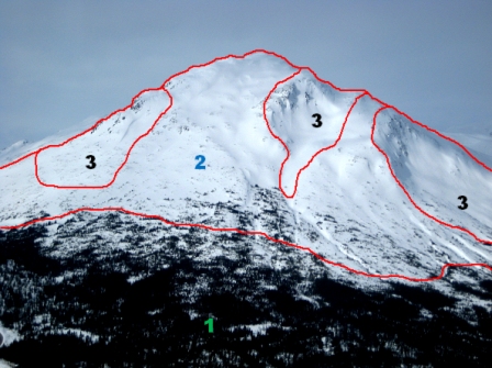
Log Cabin Mountain ATES
Chilkoot Trail National Historic Site
| Description | Class | Terrain Criteria |
|---|---|---|
| Simple | 1 | Exposure to low angle or primarily forested terrain. Some forest openings may involve the runout zones of infrequent avalanches. Many options to reduce or eliminate exposure. No glacier travel. |
| Challenging | 2 | Exposure to well defined avalanche paths, starting zones or terrain traps; options exist to reduce or eliminate exposure with careful routefinding. Glacier travel is straightforward but crevasse hazards may exist. |
| Complex | 3 | Exposure to multiple overlapping avalanche paths or large expanses of steep, open terrain; multiple avalanche starting zones and terrain traps below; minimal options to reduce exposure. Complicated glacier travel with extensive crevasse bands or icefalls. |
The technical model has been designed for users trained and skilled in the subtle nuances of avalanche terrain.
| 1 - Simple> | 2 - Challenging | 3 - Complex | |
|---|---|---|---|
| Slope angle | Angles generally < 30º | Mostly low angle, isolated slopes >35º | Variable with large % >35º |
| Slope shape | Uniform | Some convexities | Convoluted |
| Forest density | Primarily treed with some forest openings | Mixed trees and open terrain | Large expanses of open terrain. Isolated tree bands |
| Terrain traps | Minimal, some creek slopes or cutbanks | Some depressions, gullies and/or overhead avalanche terrain | Many depressions, gullies, cliffs, hidden slopes above gullies, cornices |
| Avalanche frequency (events:years) |
1:30 ≥ size 2 | 1:1 for < size 2 1:3 for ≥ size 2 |
1:1 < size 3 1:1 ≥ size 3 |
| Start zone density | Limited open terrain | Some open terrain. Isolated avalanche paths leading to valley bottom | Large expanses of open terrain. Multiple avalanche paths leading to valley bottom |
| Runout zone characteristics | Solitary, well defined areas, smooth transitions, spread deposits | Abrupt transitions or depressions with deep deposits | Multiple converging runout zones, confined deposition area, steep tracks overhead |
| Interaction with avalanche paths | Runout zones only | Single path or paths with separation | Numerous and overlapping paths |
| Route options | Numerous, terrain allows multiple choices | A selection of choices of varying exposure, options to avoid avalanche paths | Limited chances to reduce exposure, avoidance not possible |
| Exposure time | None, or limited exposure crossing runouts only | Isolated exposure to start zones and tracks | Frequent exposure to start zones and tracks |
| Glaciation | None | Generally smooth with isolated bands of crevasses | Broken or steep sections of crevasses, icefalls or serac exposure |
Using this scale
Any given piece of mountain terrain may have elements that will fit into multiple classes. Applying a terrain exposure rating involves considering all of the variables described above, with some default priorities:
- Terrain that qualifies under an italicized descriptor automatically defaults into that or a higher terrain class.
- Non-italicized descriptors carry less weight and will not trigger a default, but must be considered in combination with the other factors.
Related links
- Date modified :