
Map of some Mi'kmaw place names in Mi'kma'ki
Halifax Citadel National Historic Site
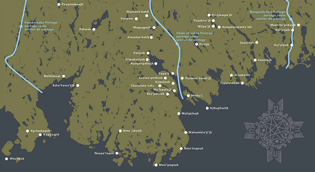
This map shows some Mi'kmaw place names in an area of Sipekne'katik on the Atlantic Coast in Mi'kma'ki.
| Mi'kmaw place name | English interpretation |
|---|---|
| Alusulue'katik (Lower Sackville) | at the measles place |
| Asoqmapskiajk (Bedford Basin) | at the rocky crossing |
| Asoqmasukwita'mk (Porcupine Lake) | to walk across the water |
| A'sukwitk (Lawrencetown) | meeting of waters |
| Eske'kewa'kik (Indian Point) | place of raw (significance uncertain) |
| Etu'panuek (Williams Lake) | two streams flowing into an opening |
| Kepe'k (Halifax Narrows) | at the narrows |
| Kepijoqjɨk (Aspotogan Harbour) | at the blocking area |
| Kitpukusisek (Mill Cove) | at the eagle's nest |
| Kjikujikwitk (Devil's Island) | meaning uncertain |
| Kjipuktuk (Halifax) | the great harbour; the great fire |
| Klujjiewpe'jk (Lake Williams) | lake of the cross |
| Kpɨteskaqnk (Aspotagan Harbour) | blockade place |
| Kul'pijuik (Petpeswick Inlet, Port Piswick) | flowing under the earth or under rocks |
| Kuowa'qmiktuk (Camp Hill) | at the pine grove |
| Kwipek (Bedford) | meaning uncertain |
| Kwipew (Sackville) | possibly "head of the tide" but meaning uncertain |
| Malklipoqt (Ingram River Reserve) | Margaret's Bay |
| Maqoqpejk (Second Lake) | large round little lake |
| Mesi'paqnuk (Cape Sambro) | meaning uncertain |
| Milpe'jk (Salmon River Long Lake) | many coves |
| Mniku'j (McNabs Island) | little island |
| Mulipjɨkejk (Herring Cove) | deep valley-like |
| Muskɨto'pukwek (Musquodoboit Harbour) | flowing out to a wide opening |
| Nespa'taqnk (Prospect) | place where an herb is mixed with tobacco |
| Nipmane'katik (Beaver Bank) | meaning uncertain |
| Nme'jukatik (Shad Bay) | place of the fish |
| Nme'kaqnuk (Ketch Harbour) | a good fishing place |
| Pakwek (Pockwock Lake) | shallow |
| Paqasimkwajk (Five Mile Lake) | at the boggy place stretching out |
| Punamu’kwati’jk (Dartmouth) | at the tomcod place |
| Pu'tijk (Lake Major) | sitting down place |
| Sesetkuk (East Chezzetcook, Chezzetcook Head) | flowing rapidly |
| Tapuisimkek (East Lawrencetown) | meaning uncertain |
| Tqoskwe'jk (Wisdom Mill Lake) | twin girls |
| Walnamkia'ji'jk (Portuguese Cove) | at the small sandy cove |
| We'kwaltijk (Northwest Arm) | end of the bay; ending without a river coming in |
| Wta’nkuk (Tancook Island) | facing the open sea |
Indigenous content in these maps and throughout the new Fortress Halifax exhibit was developed in collaboration with our partners at Mi’kmawey Debert. Map content draws upon the Mi’kmaw Place Names Digital Atlas and Trudy Sable and Bernie Francis, The Language of This Land, Mi’kma’ki (Sydney, NS: Cape Breton University Press, 2012).
- Date modified :