

Gros Morne Mountain
Gros Morne National Park
Gros Morne Mountain Closure
The summit of Gros Morne Mountain, which includes the 8 km Summit Trail, is closed to visitors from May 1 to June 27, 2024, inclusive, to protect wildlife during these critical weeks of reproduction and growth. It will reopen to the public on June 28, 2024.
Gros Morne is the second highest peak on the island of Newfoundland, exceeded only by Lewis Hill (the Cabox). Often capped with clouds, or clothed in fog or snow, the mountain's mystery is reflected in its name: Gros Morne... big lone mountain. In September 1976 this trail was named for former British Prime Minister James Callaghan in recognition of his conservation effort.
This 806 m high flat-topped mountain is a slice of Arctic tundra far south of its usual range. The habitat here used to be the quiet domain of rock ptarmigan, Arctic hare, and woodland caribou but now a trail leads to the top of this landmark. Around the summit there are views of a spectacular glacial-carved landscape: the deep fjord arms of Bonne Bay and the U-shaped trough of Ten Mile Pond. The trail head is located 7 km south of Rocky Harbour on route 430.
Your actions can easily affect the fragile and ancient community atop this mountain. Please take care to preserve this beautiful mountain so that those who follow can enjoy it too.
- Spring Closure – To protect wildlife during critical weeks of growth and reproduction, the mountain portion, from the base platform, is closed to hikers beginning on May 1 and re-opens on the last Friday in June.
- Please stay on the trail, both for your safety and to reduce your effect on fragile environments.
- Carry out all of your garbage. Buried trash is still trash.
- We recommend that visitors do not take their dogs to the summit of Gros Morne Mountain as there are risks to both dogs and wildlife. The hike to the summit can be incredibly challenging for dogs, as the rocks can cut their feet and there is a lack of access to water. The presence of dogs on the mountain can also disturb the unique wildlife that call Gros Morne mountain home – such as the Arctic hare, caribou and rock ptarmigan. Although we discourage visitors from taking dogs to the summit of Gros Morne Mountain, they are permitted if they are under physical control with a leash.
- Leave everything as you find it. Do not pick plants or collect rocks, fossils, or anything else (other than litter!) This will ensure that others can also enjoy the features of this trail.
- Do not build fire pits, shelters, or rock cairns.
Before You Head Out
It is very important to be well prepared before undertaking this hike. This is not an easy hike!!- There is no food, shelter, or water available on the mountain. Be prepared for changes in weather as well as cooler and windier conditions on the mountain.
- The complete trail is 17km long, a seven to eight hour hike at a leisurely pace. To fully enjoy the wildlife and spectacular scenery along this trail, be sure to allow yourself enough time
- Check weather and trail conditions
- Pick up your Park Pass prior to hiking the mountain.
We recommend:
- Water (at least 3 litres of water per person) since none is available on the mountain.
- Warm clothing and a windbreaker or warm coat (waterproof gear recommended) to counter the wind and unpredictable weather.
- Sturdy broken-in footwear.
- Sunscreen, Hat for warmth and/or sun
Brief Description of the Route
-
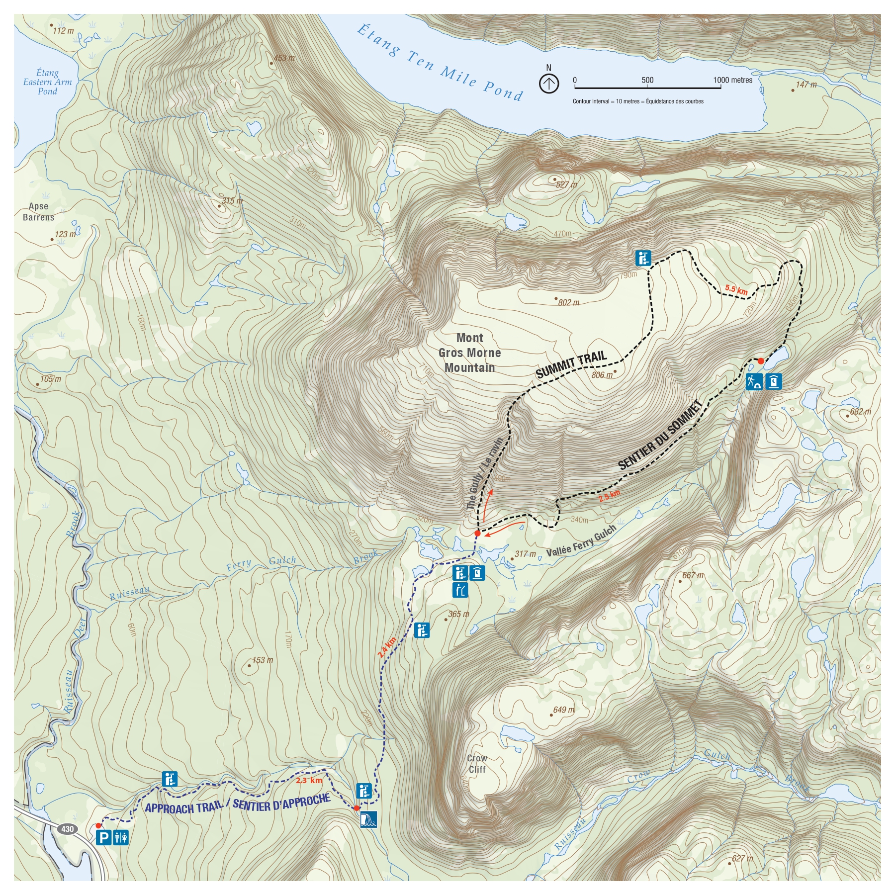
The first 4.5 km of the trail takes you to a cluster of small ponds at the base of the mountain, at an elevation of 320 m. The ascent to this point is gradual, and offers a view of Bonne Bay to the south. If time or tiredness do not permit the full hike, this can still be a worthwhile half-day outing - simply return by the same route.

-
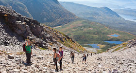
Next the trail follows a steep boulder gully to the summit of the mountain, passing through a series of zones, each of which has its characteristic plants and animals. Hikers moving through these habitats are exposed to the same conditions as the creatures that live there. These are indeed harsh places to live, so be prepared for rapid temperature changes, lack of water, high wind, and blistering sun . This is the most difficult part of the hike, and is not recommended for small children . The climb will take at least one hour as the trail gains almost 500 m in elevation.
 Gros Morne's mountain top is flat and its stunted vegetation hugs the ground. Stone cairns mark the trail across the mountaintop to the viewpoint overlooking Ten Mile Pond. Life is hard enough for the plants and animals as it is - do not increase their problems with litter, trampling, or by re-arranging the rocks that they live on and beneath.
- The trail descends the north-east flank, winding back 6 km through Ferry Gulch, and connecting with the first section of the trail.
Please stay on the trail at all times. The vegetation is old and fragile, and the cliffs are steep. It is best to hike this trail in the clockwise direction described because the gully can be dangerous to descend and there is a risk of dislodging boulders onto climbers below.
Primitive Camping
There are primitive campsites at Ferry Gulch. Camping permit required. Please register with park staff.
Related links
- Date modified :