
Greater Victoria, British Columbia: Candidate national urban park feasibility report
Other national urban park candidate sites previously published reports under the title Pre-Feasibility Report. The title has been updated to Feasibility Report to better describe the work carried out at this stage. Aside from this change in name, the report has the same purpose and intent as those published previously. This change will be in effect for any feasibility report to be published in the future for any candidate sites.
About the feasibility phase
The feasibility phase is the first step in the national urban park designation process. This process is locally driven and flexible. The activities and roles of specific partners, as well as the timing of specific activities and decision-points, will vary based on the local context. Throughout this process, Parks Canada and key partners have maintained regular communication to confirm an interest in proceeding. Broader consultation will continue to occur in the future phases.
The partners concluded that the Greater Victoria national urban park is feasible and desirable. The candidate site aligns with program objectives of conserving nature, connecting people with nature and advancing reconciliation with Indigenous peoples, and has sufficient support from local partners. The publication of this report concludes the feasibility phase. The project is now ready to move to the planning phase, in alignment with the national urban park designation process.
Feasibility assessment milestones
Parks Canada launched the feasibility phase for a proposed national urban park in Greater Victoria, BC, in 2021.
- July 2021: Statement of Collaboration signed between the City of Colwood and Parks Canada
- September 2023: Draft engagement plan prepared for the proposed national urban park
- November 2023: Partnership memorandum of understanding (MoU) signed between Te’mexw Treaty Association and Parks Canada
- January 2024: Partnership memorandum of understanding (MoU) signed between Esquimalt Nation and Parks Canada
- December 2024: First partner committee meeting
Parks Canada recognizes that the First Nations of southern Vancouver Island are an essential partner in this process, and their leadership is a key element of the project. Advancing Reconciliation with Indigenous peoples is at the core of this national urban park project and will guide the planning phase and designation of the future national urban park in Greater Victoria.
Feasibility assessment outcomes
Following bilateral discussion with key partners and stakeholders, as well as partners meetings, and conducting studies related to the site’s areas of interest, Parks Canada confirms that the Greater Victoria candidate site has met the requirements of the feasibility phase of the national urban park designation process.
In Parks Canada’s view:
The project has received sufficient support from local partners
Engagement has been undertaken with rightsholders in the area and will continue. Partners, including First Nations and municipal leadership, have expressed support. They are committed to exploring opportunities and joining together in the planning phase of the proposed national urban park in the Greater Victoria area.
The candidate site aligns with program objectives
A national urban park in the Greater Victoria area presents opportunities to advance the objectives of the National Urban Parks Program: advancing Reconciliation with Indigenous peoples, conserving nature, and connecting people with nature.
A study area has been identified
Partners identified several areas of interest for the proposed national urban park. These areas include the Parks Canada administered lands around the Fort Rodd Hill and Fisgard Lighthouse National Historic Sites, and other potential selected parcels of lands and islands in the Greater Victoria area. These parcels of land may be contiguous or non contiguous resulting in a proposed national urban park comprised of a mosaic of lands.
Site specific studies have been conducted
Initial background studies have been undertaken to inform the feasibility assessment of the proposed national urban park.
Considerations for a vision, boundary and governance have been explored
Local partners have had preliminary discussions about considerations for a vision, boundary, and administration for the potential national urban park.
Partner group members
Partners were convened for a first partner meeting in December 2024 to advance previous bi-lateral discussions regarding the proposed Greater Victoria national urban park. Current invited member governments and organizations are:
- Esquimalt Nation
- Representatives from Te’mexw Treaty Association, including represented member Nations:
- Beecher Bay (SC’IȺNEW) First Nation
- Songhees First Nation
- T’Sou-ke First Nation
- City of Colwood
- Parks Canada
What we heard
Through the feasibility phase, Parks Canada has heard from the First Nations partners and the City of Colwood that the proposed national urban park should:
- uphold and foster support for Indigenous connection and access to land, language, culture, and heritage, and embrace and amplify Indigenous knowledge systems, culture, and environmental leadership to guide protection of and connection with the land
- protect the vital terrestrial ecosystems that are reminders of the holistic connection to land, water, air, heritage, and culture in the Greater Victoria area, and support ecological connectivity, within and beyond the proposed national urban park where feasible
- provide space for nature-based education and recreational opportunities in ways that respect nature and culture and are inclusive, and support accessibility of the proposed site and natural areas through multi-modal transportation options and enhanced mobility options
- feature a collaborative, inclusive, and equitable governance arrangement, and support the education, employment, and leadership of cultural and knowledge keepers in the community, including youth, 2SLGBTQI+, women and families
Study area and areas of interest
- Urban area: Greater Victoria, British Columbia
- Total size of current study area: 44.09 ha
- Most of the lands in the current study area are located within the boundaries of the City of Colwood (see Figure 1)
- Parks Canada administered lands: Fort Rodd Hill and Fisgard Lighthouse National Historic Sites, and adjacent Parks Canada administered lands
- Islands in Esquimalt Harbour referred to as Inskip Islands
Parks Canada continues to work with partners to identify additional areas of interest for inclusion in the future national urban park. The final national urban park boundary is likely to include additional lands administrated by partners. These potential lands will be included in the study area once the potential of their inclusion is ready to be made public.
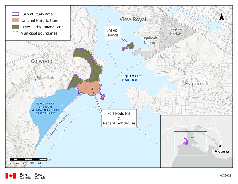
Figure 1: Current study area for the proposed Greater Victoria national urban park — text description
This map identifies the study area for the Greater Victoria national urban park candidate site. Most of the lands in the current study area are located within the boundaries of the City of Colwood. It includes Fort Rodd Hill and Fisgard Lighthouse National Historic Sites, and adjacent Parks Canada administered lands. The Islands in Esquimalt Harbour referred to as Inskip Islands are also included in the study area.
Alignment with program objectives
The current study area for the proposed national urban park in Greater Victoria aligns well with the National Urban Parks Program three core objectives:
1. Advancing reconciliation with Indigenous Peoples
The existing Parks Canada administered lands and surrounding areas are places of significant cultural importance, both historic and contemporary, and reflect local First Nations’ close connection to the sea and traditional land management and community. Some additional areas of interest identified by partners for inclusion in the future national urban park are part of treaty discussions and may be discussed in the next phases of the designation process.
During the planning phase Parks Canada will continue to foster relationships and build capacity to remove barriers and provide opportunities to support cultural practises and stewardship. During the feasibility phase, Parks Canada worked with Songhees and Esquimalt Nations to include art, language, environmental and cultural monitoring into the national historic sites’ interpretation and operations.
2. Conservation of nature
Fort Rodd Hill and Fisgard Lighthouse National Historic Sites are located within largely intact coastal forest ecosystems, including Douglas fir forests and Garry oak meadows. These ecosystems provide habitat for 12 federal, and six provincially listed species at risk, as well as numerous plants and animals of cultural significance.
The area supports species associated with traditionally managed, culturally significant landscapes, such as camas in Garry oak meadows, and continues to enable conservation and cultural harvesting practices within the community, including camas roasts. Further, a non-contiguous national urban park offers opportunity for preservation of habitat as well as showcasing a diversity of rare coastal ecosystems.
3. Connecting people with nature
The existing national historic sites are well positioned as an entry point to the wider park, connecting school groups, community events, and general tours. They currently see approximately 60,000 visitors annually, and accessibility improvements make it an all-ages opportunity for access to natural spaces.
The City of Colwood saw a population increase of 12% between 2016-2021, and the surrounding area continues to be one of the fastest growing populations in the country. The increase in population in Greater Victoria has raised the need for transportation to natural areas, including demand for multimodal options such as buses and bicycles. Transportation studies undertaken by the City of Colwood, as well as transit planning by BC Transit, have identified opportunities for creating more multimodal transportation and transit options for visitors.
Site-specific studies
The following site-specific studies were conducted as part of the feasibility report and will inform future planning activities for this site.
Draft active transportation studies
Identifies three viable schematic design options that allows the existing national historic sites and adjacent lands to be accessible by sustainable modes of transportation (walking, cycling, and public transportation), to support safe access to and from the site, and aligns with the City of Colwood’s proposed multimodal path along Ocean Boulevard.
Draft Colwood waterfront stewardship plan
A planning and management framework for the development of the Esquimalt Lagoon waterfront, including ecological, infrastructure, public access and amenity considerations. This draft plan is intended to complement the multi-use trail and transportation study listed above.
Colwood ecosystem regeneration strategy
Outlines a framework for the regeneration of ecosystems located within the Colwood waterfront Stewardship Plan. The long-term objectives behind the strategy are for the support and planning of ecosystem regeneration of the waterfront to support the proposed national urban park which could connect to the Colwood waterfront.
Fort Rodd Hill & Fisgard Lighthouse National Historic Site Ecological Management Plan
Outlines the ecological management approach undertaken at these sites to support maintenance or restoration of ecological integrity, to monitor and ensure the commemorative integrity of historic places, protect cultural and natural resources, and provide for appropriate visitor experiences.
Infrastructure report
Written by Green PI Inc for the purposes of identifying and reviewing potential locations for visitor services facilities that could be considered within the national historic sites, such as welcome and education facilities, washrooms, parking, picnic and rest areas.
Findings from preliminary partner engagement
Preliminary bilateral meetings, which included representatives from Esquimalt Nation, Te’mexw Treaty Association (representing Beecher Bay / SC’IȺNEW, Songhees, T-Sou’ke First Nations), the City of Colwood, and Parks Canada were held from fall 2022 to fall 2024 to explore the feasibility of a national urban park in Greater Victoria.
Through bi-lateral engagement Parks Canada heard:
- there is strong support to prioritize Reconciliation in all stages of planning, implementation, and potential programming, including:
- future public space should respect the rights and interests of local Indigenous peoples
- strong interest in co management and leadership from First Nations, including interest in Indigenous Protected and Conserved Areas (IPCAs) or Tribal Parks
- conservation and infrastructure projects should use a two eyed seeing approach, integrating Indigenous knowledge into management, stewardship, and operations
- access to land and natural spaces is critical, especially the stewardship by the Nations of culturally significant lands
- interest in connecting Fort Rodd Hill and Fisgard Lighthouse National Historic Sites and areas of interest to the wider community, including diverse storytelling, art, interpretation, and accessibility
- interest in opportunities for tourism and economic development, and in raising the profile of the region, including amplifying the unique culture and history of local First Nation stewards of the Greater Victoria area
- interest in identifying a name for the national urban park that reflects the history and culture of the land and water
- furthermore, conservation of and access to nature are key elements, including:
- strong support for the conservation and access to natural and cultural spaces in the area, given increasing development pressures in the Greater Victoria area
- support for removing social and physical barriers and increasing accessibility of the park for all ages and abilities
- agreement that the park should be an inclusive and accessible place
Local community and stakeholder groups
During this first phase of the national urban park process, the emphasis was to ensure First Nations rightsholders were made aware of the project and were comfortable with progressing to the next phase. Initial communications from public and stakeholders indicate support for a national urban park designation. Broader public and community engagement will take place during the planning phase.
Next steps: planning phase
The planning phase is the next step in the national urban park designation process.
Building on the feasibility phase, activities in support of the planning phase of the national urban park designation process for the Greater Victoria candidate site include:
- wider public engagement and outreach, including ongoing First Nations led community engagement
- ongoing engagement with First Nations leadership and partners, grounded in the spirit of Nation to Nation relationships
- collaboration within the partner group to develop a shared vision, confirm the study area, identify land use and access plans, and determine roles and responsibilities in stewardship and management of the national urban park
- collaboration to identify priority investments and prepare draft budget, and begin operational planning
- First Nations led identification of capacity building needs of respective Nations
- identification of opportunities and spaces for First Nations’ ceremonial and cultural land use
- completion of existing infrastructure investments and maintenance work on existing Parks Canada–administered lands
- identification of public access needs, as well as additional infrastructure and amenities
- identification of connectivity and the shared story of the non contiguous mosaic of lands
- Date modified :