
Camping and travel restrictions
Kluane National Park and Reserve
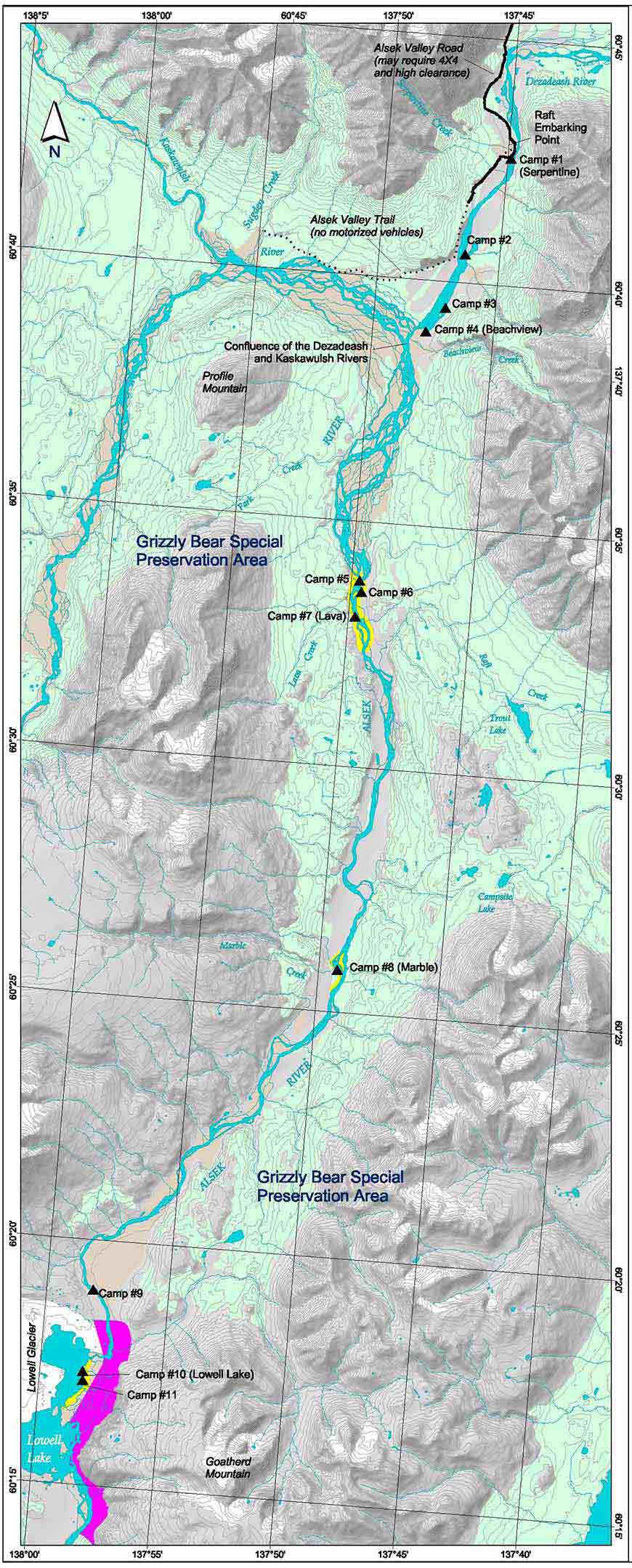
The Alsek River corridor represents a large portion of the important habitat available to black bears and grizzly bears in Kluane. To help protect grizzly bears and their habitat, the upper portion of the Alsek River (from the confluence of the Kaskawulsh and Dezadeash rivers to Lowell Lake) has been designated a Special Preservation Area.
Special Preservation Area
Special Preservation Area regulations
To reduce the potential for bear-human encounters and displacement of bears from important habitats the following restrictions are in effect within the Special Preservation Area.
-
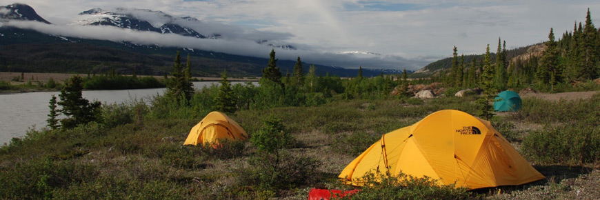
Designated camping
-
Camping is restricted to designated campsites and/or camping areas
.To minimize the effects of river travel on normal bear activity, the movements of river users should be as predictable as possible. Bears are able to adjust their activities to avoid humans based on predictable behaviour. Some predictability may be accomplished by having regularly spaced departures and by having rafters use designated campsites.
The regular use of designated campsites will make it easier for bears to adjust to human activities, but it also may raise other concerns that need to be considered. Some bears may become habituated to the regular presence of humans and therefore become bolder in their activities around these sites. This may increase the risk of bear-human encounters. For this reason, bear interactions with humans must be reported (refer to Reporting Bear Incidents).
In addition, human food and garbage scents may become more prevalent at these sites through regular use and due to careless handling of food and garbage. This could potentially attract habituated bears into the campsites to investigate scents. For this reason, campsites with lower potential for bear-human encounters or bear displacement have been identified and designated for use.
Where possible, cooking areas should be located on the active floodplain so that they are periodically flooded and cleaned of lingering scents. Proper handling and storage of food and garbage are essential to the success of any human-bear conflict program.
-
Important points regarding designated campsites
- All designated campsites have the potential for bear-human encounters and displacement of bears. Read the materials provided so that you can reduce risk to yourself and the bears that you will encounter.
- Only designated campsites were assessed for the potential risk of bear-human encounters and displacement of bears. Other potential campsites within designated camping areas may have a higher risk for negative bear-human conflicts.
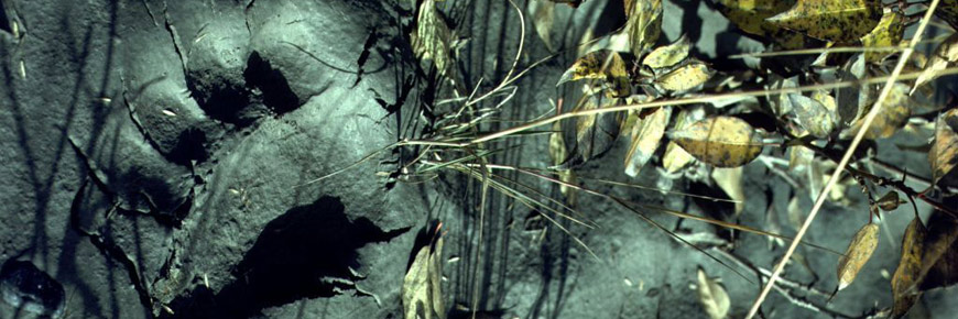
- Campsites hazard ratings are relative to other campsites assessed. High quality grizzly bear habitat is found along the entire length of the Alsek Valley. The river edge is also an important travel corridor for bears.
- Major game trails parallel both sides of the river. These trails are used regularly by bears, and in many cases trails pass close to designated campsites. Designated campsites have alternative travel routes around the area for bears to move if they detect the campsite is occupied.
- Camp in the open as far away as possible from trails and features that limit visibility.
- The benefits of designated camping can only be achieved if bears do not learn that human food and garbage can be obtained from campsites. Store food and garbage appropriately.
- Campsite designation may change if changes in bear behaviour at designated campsites occur, problems with bears develop, or lower risk alternatives are assessed.
-
Designated campsites
Campsite risk assessments
Designated campsites have been assessed as having low, low to moderate or moderate potential for bear-human encounters and possible displacement of bears from their habitat.
The location of designated campsites were chosen and assessed by considering several factors including:
- evidence of previous use by river travellers
- the abundance of bear food plants available
- the amount of bear sign such as scats, mark trees, trails and beds
- features that reduce the ability of bears and people to detect each other such as thick vegetation, prevailing winds, and noise from creeks
- geographic features that influence the likelihood of a bear travelling in an area, such as constrictions in terrain.
Serpentine Creek to the Dezadeash/Kaskawulsh Confluence
From Serpentine Creek to Beachview Creek, camping is restricted to four designated campsites. Campsites 1 and 2 are recommended because they have the lowest potential for bear-human encounters and displacement of bears.
Campsite 1 (river right) - Serpentine Creek
- UTM 8V 350199/6734055 (NAD 27)
This campsite is downstream of Serpentine Creek on the Northeast edge of a large patch of alders. A primitive road leads to this popular campsite and boat launch. There is a low abundance of bear foods at and immediately adjacent to this campsite. There has been no evidence that bears travel through this campsite regularly. The terrain at and adjacent to the campsite is flat and travel is unrestricted. Bears are not funnelled through this campsite.
Potential for encounters rated: Low
- visibility is good in areas surrounding the campsite, however a stand of alders at the campsite makes visibility poor
- this campsite is frequently used by day visitors, backpackers and river travellers so there may be higher potential for bears to obtain food or garbage at this site
Potential for displacement rated: Low
- this campsite has lower quality feeding habitat
- bears travelling along the river have alternate routes to avoid this campsite
Campsite 2 (river left) - Point of peninsula
- UTM 8V 348478/6730063 (NAD 27)
This campsite is on river left at the southern tip of the large peninsula between Serpentine Creek and Beachview Creek. Relative to other areas, food abundance is relatively low. Bearroot and horsetail are sparse. Soapberry and locoweed are scattered along the edge and within the poplar/willow strip. The campsite is open and visibility is good towards the head of the peninsula. Visibility is obstructed along the outer edges of the peninsula, which is surrounded by water. Note: when water levels are low this campsite may be difficult to access.
Potential for encounters rated: Low
- high quality bear habitat and a network of well used game trails are located at the north end of the peninsula and on the mainland river edge
Potential for displacement rated: Low
- bears are likely to choose the higher quality habitats at the head of the lagoon and on the mainland edge of the river for feeding and travel
Campsite 3 (river left) - Small point in bay before Beachview
- UTM 8V 347789/6728003 (NAD 27)
This campsite is approximately 100 - 150 m upstream from the southern tip of a small peninsula. Visibility is relatively good. The main camping area is open and the terrain is flat. Bearroot and locoweed are sparse. Soapberry is common in and along the edges of the open spruce and mixed spruce/poplar forests to the south and southeast. Kinnikinnick and red bearberry are common with patchy distribution in the same habitats as soapberry. While bears are likely to use this campsite occasionally, they can easily avoid it.
Potential for encounters rated: Low - Moderate
- abundance of bear sign and high quality of habitat increases as you move away from the campsite, thus, the potential for encounters also increases.
- camp in the open and as close to the river as possible. Hiking away from this campsite will greatly increase the potential for encounters and is not recommended.
Potential for displacement rated: Low - Moderate
- bears have alternatives to avoid the campsite if they detect people
Campsite 4 (river left) - Beachview (north side of fan)
- UTM 8V 347114/6727165 (NAD 27)
This campsite is located on the upstream edge of the large alluvial fan located upstream of Beachview Creek. There is good visibility in all directions except a thick poplar/willow patch to the southeast. There is a low abundance of bear foods. Soapberry is abundant and kinnikinnick is common along the edge and behind the poplar/willow patch. A prominent and well-used game trail, with abundant bear sign, parallels the edge of the poplar/willow patch directly behind the campsite.
Potential for encounters rated: Moderate
- bears have frequently been observed near this campsite
- abundance of bear sign and high quality of habitat increases as you move away from the campsite, thus, the potential for interactions also increases
- hiking away from this campsite is not recommended
- camp in the open and as close to the river as possible
- do not camp near the game trail
Potential for displacement rated: Moderate
- the edges of this fan and the confluence is a productive well-used feeding area with locoweed and soapberry
- bears have alternative travel routes around this campsite but may be displaced from what appears to be a major travel route along the river.
Kaskawulsh / Dezadeash Confluence to Campsite 9
Camping within this zone is restricted to one night. Two camping areas have been established on the river. The first area is at Lava Creek, which offers a choice of three assessed campsites, and the second area is at Marble Creek with one assessed campsite. Camping at designated campsites within camping zones is recommended.
Campsite 5 (river right) - Above Lava Creek
- UTM 8V 344859/6717742 (NAD 27)
Bear food and sign observed at this campsite were low. There was little evidence that bears use this area on more than an occasional basis. It is likely that most bears chose to travel on the other side of the river or possibly inland above the rock face. There are higher quality habitats for bears immediately upstream of this campsite.
Potential for encounters rated: Low
- rocky knolls restrict visibility
- stay alert for bears and make noise when walking around the lava rocks, particularly when walking to and from the lava pool to the west
- hiking away from this campsite is not recommended
Potential for displacement rated: Low
- there are better food sources upstream of the campsite
- bears likely chose alternative routes for travel around this campsite
Campsite 6 (river left) - Lava Rocks
- UTM 8V 345103/6717252 (NAD 27)
There is a low to moderate abundance of bear foods at this campsite. There are patches of bearroot, kinnikinnick and horsetail. Locoweed is scattered in the openings. Soapberry is sparse in the open flats around the campsite but more abundant along the edges of the trees. There was relatively little bear sign observed at this campsite. Visibility is poor at the base of the large rock outcrop in the small bay to the north. Visibility is good at the campsite downstream of the large rock outcrop. If bears detect people they have alternatives to avoid the campsite. Note: that when water levels are low this campsite may be difficult to access.
Potential for encounters rated: Low - Moderate
- camp in the large open area downstream of the large rock outcrop
- poor visibility at the upstream campsite in the small bay will make it more difficult to detect bears
- the potential for surprise encounters increases with distance from the campsite because vegetation and rock reduce visibility
- the safest route to the lava pools is to hike in the open where visibility is the best, downstream from the campsite and into the open flats before cutting upstream over to the rocks
Potential for displacement rated: Low - Moderate
- the surrounding area is open rock that offers alternative travel routes up slope
Campsite 7 (river right) - Lava Creek
- UTM 8V 344825/6716320 (NAD 27)
This campsite is beside the small creek just downstream of Lava Creek. Bearroot, kinnikinnick, horsetail and soapberry are less abundant at this campsite. Locoweed is common on the flats at the campsite. All major bear foods are abundant up slope and downstream of the campsite. Bear sign was low to moderate at the campsite but bears may use the trail that leads up slope from the campsite. Visibility is relatively good at the campsite but decreases in all directions with distance from the campsite. It is unlikely that many bears travel along the river upstream of Lava Creek because of impassable cliffs. Bears are most likely to travel on the East Side of the river or further inland. Because travel along the river to the north appears to be restricted, areas near this campsite may be used by bears for crossing the river. Bears may chose to travel down the trail from higher quality habitats to the west into the campsite. However, the campsite is in the open and bears are likely to detect people before they get into the campsite.
Potential for encounters rated: Low - Moderate
- camp below the rock bluffs on either side of the smaller creek downstream of Lava Creek rather than beside Lava Creek so bears can avoid the camp
- hiking from this campsite is not recommended
Potential for displacement rated: Low - Moderate
- this campsite may be located near a favoured river crossing area for bears. Therefore, movement patterns may be disrupted. However, with regular human use of this campsite bears will learn to expect people and cross the river further downstream
Campsite 8 (river right) - Marble Creek
- UTM 8V 344568/6702934 (NAD 27)
Campsite 8 is located on the downstream edge of Marble Creek. Soapberry is common and abundant in patches in and on the edges of the willow/poplar habitats around the campsite and the long poplar / willow / spruce / alder strips that parallel the river. Kinnikinnick was abundant in patches. All other bear food plants around this campsite are in relatively low abundance. There was a moderate amount of bear sign at this campsite. Visibility is relatively good at this campsite because it is relatively open on three sides. Visibility is poorest to the south because of willows. Bears are not funnelled through this campsite and have alternatives to avoid the campsite if they detect it.
Potential for encounters rated: Low - Moderate
- camp in the open flats away from the shrub edges to give bears the greatest opportunity to detect and avoid people
- hiking away from this campsite is not recommended because visibility is poor and the chances of surprising a feeding or travelling bear is high
Potential for displacement rated: Low - Moderate
- alternatives for bears to bypass this campsite are present
- there are areas with abundant bear foods upstream of Marble Creek and on the opposite side of the river
Campsite 9 (river right) - Above Lowell Lake
- UTM 8V 335616/6690567 (NAD 27)
This campsite is located on river right approximately 2.5 km above Lowell Lake. People camping at the site will likely hike to the moraine (>20 minutes) for a view of the glacier. There is a good place to pull boats in. The campsite is in open Willow-Dryas shrub habitat. There is a small patch of alder in the middle of the campsite that could be used as a windbreak for a kitchen. Upstream there is balsam poplar with scattered spruce and thick shrubs including soapberry ( Shepherdia canadensis ) and willow ( Salix spp.). Downstream there is a thick alder ( Alnus crispa ) and willow strip along the river. Inland there is a patch of less dense spruce ( Picea glauca ) with balsam poplar ( Populus balsamifera ) and soapberry. Behind this patch is Dryas spp. habitat.
Potential for encounters rated: Low - Moderate
Encounter concern:
Spring: L-M Summer: L-M Late Summer: L-M- Visibility is restricted by vegetation the farther one moves form the site. Visibility concerns are high in some places but moderate overall.
- Trails are broken. Terrain and vegetation do not funnel travel. However, travel concerns increase upstream of the campsite because the moraine is closer to the river edge.
Potential for displacement rated: Moderate
Displacement concern:
Spring: M Summer: M Late Summer: M- Alternatives for bears to bypass this camp exist
Recommendation
Generally a lower risk campsite but risk increases upstream and downstream of the campsite. Hiking in this area will increase the risk for surprise encounters because there are areas with low visibility and habitat potential increases with distance from the campsite. People walking downstream will be walking into prevailing winds. This site should be considered as a temporary site when weather conditions prevent a safe advancement to the Lowell lake sites.
Lowell Lake
Camping at the base of Goatherd Mountain is prohibited. Camping is permitted on the western outer edges of glacial till along the eastern shore of Lowell Lake. Camp as far away from the base of the mountain as possible, minimize the length of your stay and keep your activities at the base of the mountain to a minimum.
-
-
One night restriction
Camping between the confluence of the Kaskawulsh and Dezadeash Rivers and campsite # 9 above Lowell Lake is limited to one night only per group per trip.
The goal of the one night restriction is to minimize the number of people in the Special Preservation Area at any one time, and thus reduce human caused displacement of bears.
-
Lowell Lake
Camping at Lowell Lake is limited to two nights maximum per group per trip..
The goal of the two night restriction is to minimize the number of people in the Special Preservation Area at any one time, and thus reduce human caused displacement of bears.
-
Goatherd Mountain Closure Area
Camping is prohibited in the Goatherd Mountain closure area and is limited to the eastern edge of Lowell Lake with a maximum stay of two nights.
The base of Goatherd Mountain is a major travel route for bears moving past Lowell Lake. Use of this area has a high potential for encounters and for the displacement bears. Bear movement is funnelled through open non-vegetated terrain along the base of a steep mountain face. Camping outside the closure area, and minimizing your length of stay at Lowell Lake, will help to reduce the long-term human impacts on bears.
-
Off river travel
Campsite hazard ratings do not take hiking into consideration. Off river travel (e.g. day hikes) is not encouraged due to the risk of bear-human encounters and the possible disturbance to bears. Do not leave rafts or camps unattended while hiking. At least one person must stay to watch the boats and/or camp.
-
Food storage
© Ron Chambers It is mandatory to ensure that all attractants are stored in an approved manner so that they are not accessible to bears.
Bears are opportunistic and quick to learn. As they become habituated to people, the potential for bears to obtain attractants such as human food and garbage increases. Food-conditioned bears are dangerous. If human food and garbage are not secured from bears, it is only a matter of time before food-conditioned bears become a threat to human safety.
The Alsek River corridor will only continue to be a wilderness area, free of food conditioned bears, by preventing bears from accessing your food and garbage. This is your responsibility as a river user. These simple steps will help:
- Keep your campsite clean and leave it clean when you leave
- Never leave your campsite, boats, or food unattended
- You are required to use IGBC certified bear resistant containers (coolers, canisters, raft boxes etc) and/or IGBC certified portable electric fences to secure all attractants such as food and garbage.
Preventing bears from accessing attractants requires extra effort. As a river user, this is the most important thing you can do to preserve the grizzly bear populations in this region and increase your personal safety.
Electric fences
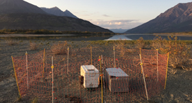
© Jeffrey Peter Electric fences are an effective method of securing attractants when they are set up and used properly. Please ensure your fence is an IGBC certified model and that you know how to set it up so it meets the USFS guidelines.
If you plan to use an electric fence to secure your attractants, please let our staff know when requesting your put-in date. Make sure the exact model you are using is on the IGBC certified products list (note: some models have similar names but not all are certified).
Ensure that you can set up your fence so it meets the requirements for proper use. You should practice setting up and testing your fence prior to the start of your trip. When finalizing your registration you will be asked for the IGBC Certification number of your fence. Trip leaders will have a mandatory meeting with the KNPR Duty Officer, where you will be expected to set up and demonstrate proper use of your electric fence prior to being issued your wilderness permit. You must have a voltmeter and demonstrate using it to test your fence.
System requirements for portable electric fences System component Requirement Controller output 0.11 Joules (minimum) Tested voltage (every hot line) 5000 Volts (minimum) Strands of wire (per hot line) 7 (minimum) Ground rod length 0.31 m (minimum) Distance between lines 0.28 m (maximum) Fence height 0.8 m Distance from fence to attractants inside 0.45 m (minimum)
Regulations for the whole river
- Fire pans are required for campfires. Camp stoves are recommended, since driftwood and deadwood are limited and difficult to obtain
- All garbage and human waste must be packed out. Human waste disposal systems are available for rent from commercial suppliers.
- Removal of natural or historical objects from the park is prohibited
- Firearms are prohibited in Kluane National Park and Reserve
- Motors are prohibited
- Date modified :