
Other areas
Rouge National Urban Park
Explore the history of various areas of the park, from an old logging trail, to schoolhouses, to former campgrounds and cottage getaways.
Graham Park
Before it was the Glen Rouge Campground, this area was the site of a different campground called Graham Park, which was a popular getaway for Toronto residents.
Although the Rouge Valley was historically known for its rich forests and agricultural lands, it was also a place for leisure. In particular, areas near the shores of Lake Ontario, the Rouge River, and the Little Rouge River were popular locations for city folks from Toronto to relax and experience nature. One popular destination was Graham Park, a campground nestled along the banks of the Rouge River.
Established in 1923, Graham Park was owned and operated by Jack Graham and his family. At the time, Graham Park had about 10 sites and allowed large tents, trailers, or seasonal residence. Campers had plenty of activities to keep them entertained, including baseball, horseshoes, fishing, dancing, and playing in a local corn field. A swimming pool was created by placing a dam in the Rouge River, allowing campers to cool off on warm summer days. The park also had a small dance pavilion and a restaurant called Brigadoon.
After Hurricane Hazel hit Toronto in 1954, the Toronto and Region Conservation Authority (TRCA) purchased the land from Jack Graham as part of their flood mitigation plans. The TRCA later re-opened the park as Glen Rouge Campground. The prefix “Glen” comes from the Scottish and Irish Gaelic word for a small, narrow valley. The name Glen Rouge therefore means the “small, narrow Rouge Valley”.
Hurricane Hazel
Hurricane Hazel hit Toronto in 1954, claiming 81 lives and damaging many parts of the city, including several areas within the park.
Hurricane Hazel struck Toronto on October 15, 1954, bringing winds of 110 km/h and 285 mm of rain in 48 hours. Eighty-one people died, roads and bridges were washed out, trains were derailed, and thousands of people were left homeless due to the destructive flooding that occurred in the city's river valleys. Damages were estimated at $100 million (well over $1 billion today).
Hurricane Hazel impacted many areas of the park. Cecil White's Venice of the North development at Rouge Beach was severely damaged by the storm, causing the project to be abandoned. Graham Park, a campground along the Rouge River, was also destroyed by the flooding. The land was later acquired by the Toronto and Region Conservation Authority and is now the site of Glen Rouge Campground. A bit further north, the flood waters washed away the swimming hole dam at the Rouge Valley Inn, near Twyn Rivers Drive.
Several bridges in the park were also washed out, including the bridge on Old Finch Avenue, near the Finch Meander area. To restore traffic flow through the area, a number of Bailey bridges were installed by the 2nd Field Engineer Regiment of the Canadian Military Engineers. The bridge on Old Finch Avenue is the last of these remaining in service in Toronto. Hurricane Hazel also damaged the campground and cottage area at Woodland Park and washed out the bridge at Reesor Road and Steeles Avenue.
Significant changes were made in the aftermath of Hurricane Hazel. A 1956 report gave the Rouge, Duffins, Humber, and Petticoat (RDHP) Conservation Authority a mandate to acquire and manage properties for flood control purposes. Today, many of these lands are valuable conservation and recreation areas. In 1957, the RDHP Conservation Authority merged with the Humber Valley and Etobicoke-Mimico authorities to create the Metro Toronto Regional Conservation Authority (MTRCA). They developed a "Plan for Flood Control and Water Conservation", which led to the construction of dams, reservoirs, and stream channel improvements for flood mitigation.
The report also suggested that the Rouge offered great potential "for the development of a large-scale wilderness parkland and nature preserve", though no action was taken on this suggestion at the time. It would be several more decades before Rouge National Urban Park would be established.
Mast Trail
This trail commemorates the original Mast Trail which was used to transport large trees down to Lake Ontario on the way to ship building yards in Europe.
Transportation of various products by overland routes became increasingly important during the 19th century. Settlers made use of Indigenous trails along with some of their own carved out roads, which first started as trails slashed through the bush. One of these carved out roads was the Mast Road, which was used to transport large pine trees that were logged for ship masts. The road ended on the Little Rouge River where the logs were floated down the river to Lake Ontario and eventually transported to ship building yards in Europe.
Some of the demand for ship masts was driven by the Napoleonic Wars. Timber, particularly the old-growth pines needed to build ship masts, was in short supply in Britain. Masts had to be shipped in from forests along the Baltic Sea. The British Royal Navy was a significant threat to Napoleon’s forces so in an attempt to weaken their navy, Napoleon declared an embargo, barring other nations from trading with Britain and cutting off their supply of ship masts. In response, Britain began to source their masts from the then-plentiful old growth forests in the Canadian colonies. Some of these masts were cut from the forests of the Rouge Valley and transported down the Mast Road, along the St. Lawrence, and across the Atlantic. Remnants of the Mast Road make up the Mast Trail in Rouge National Urban Park today.
Schoolhouses
By the mid-1800s the Rouge Valley was home to several schools, including the Locust Hill School House and the Cedar Grove School House, which still stand today.
As communities in the Rouge Valley became more established, formal education became necessary for children to learn new skills, develop citizenship values, and gain discipline. Starting in the 1840s, Egerton Ryerson helped to establish a new educational system for Ontario (then known as Upper Canada), intended to make good schooling accessible to all. Local school boards were responsible for hiring teachers, and erecting and maintaining school buildings. By the 1850s several schools were established in the Markham area, including the Locust Hill School House, located on Reesor Road north of Highway 7, and the Cedar Grove School House, located on 14th Avenue between Reesor Road and the Little Rouge River.
Built in 1869, the Cedar Grove School House was unique because it contained a gallery where adults could watch their children while class was in session. The school served many families that lived in the community of Cedar Grove, operating for nearly 100 years before it closed in 1966 due to educational reform. Today, the schoolhouse serves as the Cedar Grove Community Centre and occasionally hosts Rouge National Urban Park events and meetings.
Venice of the North
The Rouge Beach area was once a popular resort and cottage area in the late 19th and early 20th centuries. One man even had a vision to build a "Venice of the North" here, though his dreams ultimately never materialized.
In the early 19th century, a growing industrial economy began to surround the predominantly rural areas of the Rouge Valley. Water-based methods of transportation were often used to get agricultural and other products to market. The mouth of the Rouge River even had some of its own shipbuilding with at least four ships, sailing vessels, and steamers being constructed between the 1820s and 1880s.
As time progressed into the late 19th and early 20th centuries, the Rouge became a centre for leisure and recreation, a place for city-dwellers to escape into nature. Rosebank, for example, was a large-scale resort that began to develop in the 1870s, and quickly became an affordable and popular summer resort, offering camping, picnic grounds, and a dance hall. Morgan's Park was another area where city dwellers could escape the "roar of cities", having several cottages that eventually became year-round homes. Both Rosebank and Morgan's Park were located east of where Rouge Beach is today, on the other side of the Rouge River.
In the early 1920s, Cecil White, a local real estate broker, envisioned building a "Venice of the North" in the marsh area, calling it the Rouge Hills. He hired a team of Italian architects to design the project, which was to include roads, a network of canals, an artificial lake, and a bridge over the Rouge River. The project stalled once when the Great Depression hit in 1929 and again with the start of World War II in 1939. When Highway 401 reached the area in 1942, construction sped up again. Unfortunately, White passed away in 1946, before the project was completed. His wife Gladys continued work on the development, but when Hurricane Hazel hit Toronto in 1954, the project was largely destroyed and White's dream was abandoned. Today, one of the canals can still be seen on Google maps.
Woodland Park
The land around the Woodland Trail was home to a thriving camping and cottage area from the 1920s until the land was expropriated for the proposed Pickering airport in 1974.
This area was once a popular camping and cottage destination that drew thousands of visitors seeking to escape from the city life in Toronto. The lands that make up the Woodland Trail today were inherited by Nellie Lapp from her father in 1922. The Lapps were one of the original pioneer families that settled in this area in the early 1800s. The property was originally home to a cattle farm but Nellie soon opened it up to picnickers and campers and established the Woodland Park Campers' Association. She also leased some of the land to cottagers. Woodland Park had picnic grounds, playing fields, refreshments stands, and a large swimming pool created by damming the Little Rouge River. The park drew in many city residents looking for a quick vacation and was also popular with school and church groups.
Nellie was a committed temperance advocate and enforced a strict no-alcohol policy at her park. When she sold the park to Austin Reesor in 1950, he agreed to keep the park a dry zone. Woodland Park continued to grow over the years and hosted a popular apple butter festival every fall. By the 1970s there were as many as 80 cottages here. Woodland Park was expropriated for the proposed Pickering airport in 1974 and was slated to become part of the planned city of Cedarwood. Austin Reesor opposed the airport plans and co-founded the group People or Planes, which fought to protect farmland from the airport development.
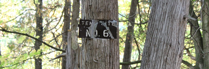
Traces of this area's rich history can still be seen while hiking along the Woodland Trail. Concrete remnants from the swimming pool can be found in the Little Rouge River, along with the foundations of a former cottage. If you look carefully, you may also notice a sign for "Tent site 6" tacked onto a tree beside the trail.
This area was once a popular camping and cottage destination that drew thousands of visitors seeking to escape from the city life in Toronto. The lands that make up the Woodland Trail today were inherited by Nellie Lapp from her father in 1922. The Lapps were one of the original pioneer families that settled in this area in the early 1800s. The property was originally home to a cattle farm but Nellie soon opened it up to picnickers and campers and established the Woodland Park Campers' Association. She also leased some of the land to cottagers. Woodland Park had picnic grounds, playing fields, refreshments stands, and a large swimming pool created by damming the Little Rouge River. The park drew in many city residents looking for a quick vacation and was also popular with school and church groups.
Nellie was a committed temperance advocate and enforced a strict no-alcohol policy at her park. When she sold the park to Austin Reesor in 1950, he agreed to keep the park a dry zone. Woodland Park continued to grow over the years and hosted a popular apple butter festival every fall. By the 1970s there were as many as 80 cottages here. Woodland Park was expropriated for the proposed Pickering airport in 1974 and was slated to become part of the planned city of Cedarwood. Austin Reesor opposed the airport plans and co-founded the group People or Planes, which fought to protect farmland from the airport development.
Traces of this area's rich history can still be seen while hiking along the Woodland Trail. Concrete remnants from the swimming pool can be found in the Little Rouge River, along with the foundations of a former cottage. If you look carefully, you may also notice a sign for "Tent site 6" tacked onto a tree beside the trail.
Related links
- Date modified :