
Snowmobile Map
Gros Morne National Park
Click here to download pdf of map (PDF 3.7 MB).
Click the link to download the snowmobile GPS track files (gpx file type)
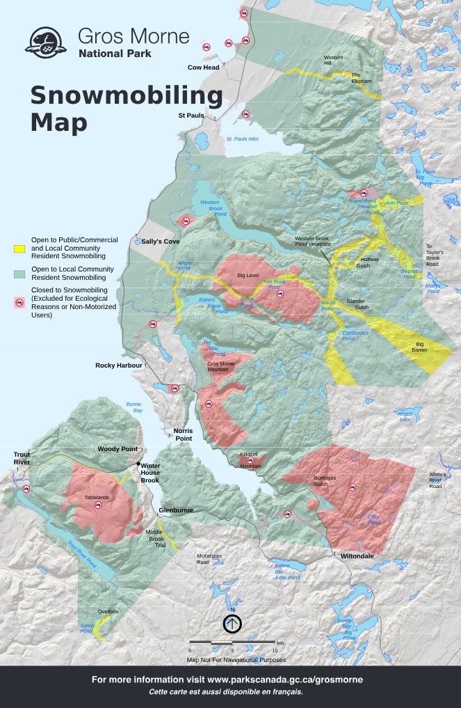
Description of Closed Areas
Stanford River-Lower Head: This is the best example of a sand dune ecosystem in the park and it includes an inter-tidal sandy beach. Also, the limestone cliffs at Lower head are exceptional fossil sites. From Lower Head to the park boundary, there’s an undisturbed coastal tuckamore forest.
Stearin and Belldowns Islands: These islands are important nesting areas for common and arctic terns as well as other seabirds such as eider ducks, gulls, and kittiwakes. They are the only significant coastal islands in the park.
St. Pauls Inlet Salt Marsh: This area is made up of a unique, fairly undisturbed salt marsh. It protects a number of rare wetland plants and is also an important habitat for shore birds, or “beachy” birds.
Frontal Slope of Western Brook Pond: This area has plant communities that are made up of arctic-alpine plants not usually seen in lowland areas of the park.
Killdevil: Rare plant communities live on the cliffs near the summit of Killdevil. The lower slope contains white birch and a heath shrub community that is the result of fire. Fire origin forests like this are rare in the park.
Heather Pond: Heather Pond is the best example of a large, deep (113 metres), fishless, alpine lake in the park. Also found here is the only known population in eastern North America of the rare plant, the Mountain Fern.
Big Level: This barren is a traditional caribou calving ground and contains important habitat for rock ptarmigan and arctic hare. The area has large snow beds which have rare plant communities and a large area of patterned sedge fens, a peat-land vegetation type found on poorly-drained, gently-sloped sites of the alpine plateau.
Tablelands: The Tablelands are an internationally significant geological feature. It is one of the reasons that Gros Morne is designated a UNESCO World Heritage Site. Its unusual geology results in some unique and rare plant life and it’s also the only known nesting area of significance for Greater Yellowlegs.
Non-motorized recreational areas: We also need to ensure that Gros Morne’s other winter enthusiasts can find the wilderness experience they are looking for. Areas that were traditionally used by backcountry skiers and snowshoers were set aside as non-motorized recreational areas to ensure they can find solitude and undisturbed snow. These areas include: Burridges Gulch–Clifty Pond, and Gros Morne Mountain–Crow Gulch–Big Hill.
Cross Country Ski trails: Ski trails can be found at Trout River Day Use Area, Lomond–Wigwam Stuckless, Visitor Centre, Berry Hill Campground and Shallow Bay Campground. Machines destroy the set tracks and pose safety concerns for other users.
Related links
- Date modified :