
© Ditidaht First Nation
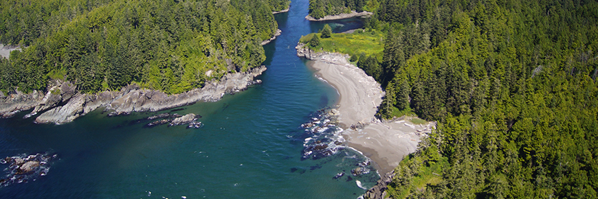
West Coast Trail's Balaats’adt (Nitinaht Village) Trailhead
Pacific Rim National Park Reserve
The light stations and surrounding grounds at Carmanah Point and Pachena Point are closed to the public. Please respect all posted notices and signs. Due to the increase in reports of human-wildlife interactions on the West Coast Trail, Parks Canada strongly recommends that a minimum of one person per group carry bear spray and know how to use it.Carmanah Point and Pachena Point Light Stations are closed to the public by Superintendent Order.
Bear spray
Important information
The West Coast Trail is a marquee adventure for the serious hiker. But a six to eight day hike can be intimidating, even to the most seasoned adventure seeker. A mid-point entrance at Nitinaht Narrows (only accessible by water from Balaats’adt (Nitinaht Village)), allows hikers to tackle a shorter portion of the West Coast Trail.
Hikers using the Balaats’adt (Nitinaht Village) Trailhead should plan for the same rigorous and challenging excursion as those hiking the entire length of the West Coast Trail.
Start planning your adventure today! Don’t forget to read our West Coast Trail Preparation Guide to ensure you’re well prepared for the best experience possible.
Pachena Bay Campground – Huu-ay-aht First Nation
Starting or ending your trip at Pachena Bay? Why not book a night at Huu-ay-aht First Nation’s Pachena Bay Campground? This campground is owned and operated by the Huu-ay-aht First Nation, who welcome you to their traditional territory.
Itineraries
Want to know what an itinerary from the Balaats’adt (Nitinaht Village) Trailhead might look like? The itineraries below are only suggestions and can be modified to suit hikers’ abilities.
Note: At any point during the season, campgrounds may be closed due to wildlife and/or trail conditions. The itineraries below are suggestions and hikers may be required to use an alternative campground nearby.

Travelling south – Nitinaht Narrows to Gordon River (42 km in total)
Day 1: Nitinaht Narrows to Cribs Creek
- Kilometre marker: 32.5 km to 42 km
- Travel distance: 9.5 km
- Points of interest:
- 38 km - An anchor, and just past it the Dare Shipwreck, lie amongst the rocks in plain view.
- 39 km - Dare Beach is a nice, though narrow, patch of beach in an area of almost entirely rocky coastline.
- 42 km - Cribs Creek features a natural breakwater along with many tide pools.
- Itinerary:
- 7:00 a.m. – Attend the pre-hike briefing at the Balaats’adt (Nitinaht Village) Visitor Centre in Balaats’adt (Nitinaht Village).
- 8:00 a.m. – Board the Balaats’adt (Nitinaht Village) Water Taxi up to the Nitinaht Narrows and the entrance to the West Coast Trail. The water taxi will first stop on the north bank and pick hikers up, then carry on to the south bank of the Narrows where you will start your hike.
- Start hiking south towards Cheewhat River and cross the Cheewhat Bridge. Between Cheewhat River and Carmanah Point, follow either the beach or the trail and stop for the evening at Cribs Creek at 42 km.
Day 2: Cribs Creek to Walbran Creek
- Kilometre marker: 42 km to 53 km
- Travel distance: 11 km
- Points of interest:
- 48 km – Take in the breathtaking ocean scenery near Bonilla Point, the sea stacks and Bonilla Falls.
- Itinerary:
- From Carmanah Point, the trail follows the beach until Walbran Creek at 53 km where you will encounter long wooden ladders heading in either direction from the campsite, as well as a cable car crossing.
Day 3: Walbran Creek to Camper Creek/Bay
- Kilometre marker: 53 km to 62 km
- Travel distance: 9 km
- Points of interest:
- 56 km - Logan Creek is famous for its spectacular suspension bridge crossing and the wooden ladders on either side of the creek.
- 58 km - Cullite Creek/Cove is a picture-perfect beach surrounded by steep cliffs.
- Itinerary:
- The trail between Walbran Creek and Camper Creek/Bay is through the forest and is considered by most to be the most challenging section of the trail, with mud, roots, and many ladder systems to contend with.
Day 4: Camper Creek/Bay to Thrasher Cove
- Kilometre marker: 62 km to 70 km
- Travel distance: 8 km
- Points of interest:
- 67 km – The sea caves at Owen Point are accessible during low tides along the beach route. These caves have been carved out by surges of the Pacific Ocean over time and the vivid colors reflect the mineral deposits from both the rock and the sea salt.
- Itinerary:
- If you access the beach at 65 km, you can walk on the sandstone shelf at low tide only (be very careful), until you reach Owen Point.
- After Owen Point, the beach route is all big boulders until you reach Thrasher Cove. The boulder route is very slow hiking. There are several surge channels in the sandstone, and you will need to consult the tide tables. If the tides are high or you do not want to do this challenging boulder route then choose to take the inland forested route.
Day 5: Thrasher Cove to Gordon River
- Kilometre marker: 70 km to 71 km
- Travel distance: 5 km
- Points of interest:
- At 73 km, there is an old piece of logging equipment called a “donkey engine”. This is also one of the highest points on the trail.
- Itinerary:
- It is a long steep climb out of Thrasher Cove to the main trail.
- At the junction, turn right and head towards Gordon River through the forest.
- From the junction to the Gordon River, the next four to five hours are on difficult uneven trail.
- Once at the end of the trail, raise a buoy in the tree to signal the ferry operator.
- Note that the last ferry ride is at 3:30 p.m.
Transportation to and from the trailheads
You will need to arrange ground transportation to and from the West Coast Trail trailheads. You can either arrange for transportation to Balaats’adt (Nitinaht Village) and leave your vehicle at the Gordon River Trailhead, where you will be exiting, or you can leave your vehicle at Balaats’adt (Nitinaht Village) and arrange transportation back to your vehicle when you exit the trail at Gordon River.
Travelling north – Nitinaht Narrows to Pachena Bay (33 km in total)
Day 1: Nitinaht Narrows to Tsusiat Falls
- Kilometre marker: 33.5 km to 25 km
- Travel distance: 8 km
- Points of interest:
- 27 km – If you decide to take the beach route you will pass through the Hole-in-the-Wall at Tsusiat Point.
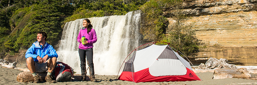
- 23 km – Tsusiat Falls is an iconic waterfall that offers a wonderful opportunity to cool off and one of the more popular campgrounds.
- Itinerary:
- 7:00 a.m. – Attend the pre-hike briefing at the Balaats’adt (Nitinaht Village) Visitor Centre in Balaats’adt (Nitinaht Village).
- 8:00 a.m. – Board the Balaats’adt (Nitinaht Village) Water Taxi up to the Nitinaht Narrows and the entrance to the West Coast Trail. The drop off point is on the north bank of the Narrows where you will begin your hike.
- Start the moderately easy hike north to Tsusiat Falls, following beautiful views from high rocky cliffs. The trail drops down and follows the forest near the beach past the Ditidaht First Nation Comfort Camping at Tsuquadra Point. Here, either access the beach if the tides are low enough, or stay on the forested trail.
Day 2: Tsusiat Falls to Darling River
- Kilometre marker: 25 km to 14km
- Travel distance: 11 km
- Points of interest:
- 20 km – Check out the large anchor from the steam ship Woodside.
- 18 km – The Valencia Bluffs lookout gives a view of where the wreck of the Valencia lies —a steamer that went down in 1906 with over 125 lives lost.
- Itinerary:
- Start by hiking up the steep set of ladders to the trail and cross the Tsusiat bridge heading north.
- Take the trail through this area all the way to Klanawa River to the first cable car.
- After the river, the beach is the only route to follow until Trestle Creek.
- From Trestle creek, the trail goes up again to more viewpoints.
- Continue over the suspension bridge at Billy Goat Creek and on to Tsocowis Creek.
- From here to Darling River, walk the forested trail or the beach, depending on tides.
- Crossing the Darling River through the water at a low tide makes for an easier crossing. If the river is flooded, crossing can be dangerous and should not be attempted until water levels drop.
Day 3: Darling River to Pachena Bay
- Kilometre marker: 14 km to 0 km
- Travel distance: 14 km
- Points of interest:
- 9 km – Just past the lighthouse, there is a short trail to a viewpoint for a sea lion haul out rock where many stellar sea lions bask in the sun.
- Itinerary:
- On the last day, hike along the beach to Michigan Creek then on the trail to Pachena Point Bay.
- From Michigan Creek, it is approximately five hours of trail hiking to Pachena Bay.
- The trail meanders through a lush temperate rainforest to Pachena Bay and the West Coast Trail orientation centre, where you must register off the trail.
Transportation to and from the trailheads
You will need to arrange ground transportation to and from the West Coast Trail trailheads. You can either arrange for transportation to Balaats’adt (Nitinaht Village) and leave your vehicle at the northern trailhead near Pachena Bay, where you will be exiting, or you can leave your vehicle at Balaats’adt (Nitinaht Village) and arrange transportation back to your vehicle when you exit the trail at Pachena Bay.
Related links
- Date modified :