
02
Jasper National Park
Jasper National Park of Canada
Marmot Basin Ski Area Site Guidelines for Development and Use
5.1 Developed Area
Ski Area Management Guidelines
"The existing Developed Area represents the area modified for skiing or other uses within the leasehold through construction of physical works, or through clearing/removal of trees and other vegetation, landscaping, terrain modification or other activity associated with ski area operation. It includes ski runs, lift lines, parking areas, commercial buildings, operational buildings and forested areas between ski runs. It does not include Undeveloped Areas, Un-serviced Terrain or Un-skied Terrain. The perimeter of the Developed Area will be determined by:
- the top terminal of the upper-most lifts;
- the outer limits of formally cut ski runs/gladed areas or approved Ski Terrain; and
- the perimeter of base/parking, staging and operational areas.
Inside the existing Developed Area, new development can be considered where potential ecological impacts can be mitigated.
Outside the existing Developed Area, new development can be considered if there is a Substantial Environmental Gain within or adjacent to the leasehold."
Page 2 and 3, Ski Area Management Guidelines , Minister of Environment, December 7, 2006
Objectives
- Improve protection of Whistlers Creek bed area and surrounding up-slopes including Woodland Caribou habitat and a goat mineral lick.
Existing Situation
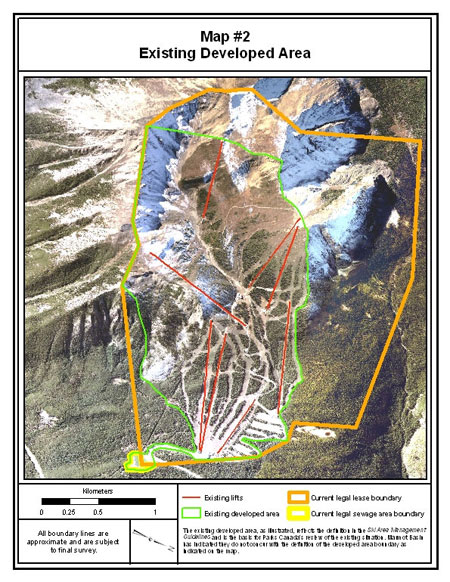
- Map #2, below, outlines the existing Developed Area 2 . It encompasses 361 ha.
Site Guidelines
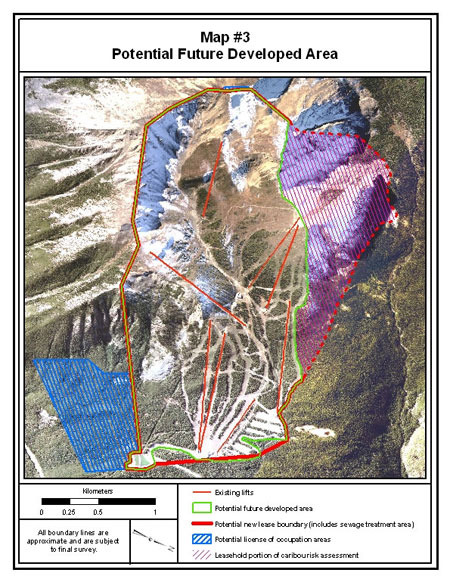
5.1.1 As an exception to the Ski Area Management Guidelines, as set out in Section 4.0, an expansion to the Developed Area can be considered as shown in Map #3. The adjusted Developed Area covers 437 ha and will be the basis for preparation of Long-Range Plans once the leasehold has been reconfigured to remove the Whistlers creek bed area, and surrounding up-slopes, to the extent shown on Map 1.
2 The existing Developed Area, as illustrated in map #2, reflects the definition in the Ski Area Management Guidelines and is the basis for Parks Canada's review of the existing situation. Marmot Basin has indicated they do not concur with the definition or the Developed Area boundary as indicated on the map.
- Date modified :