
Self-guided tour
Fort Anne National Historic Site
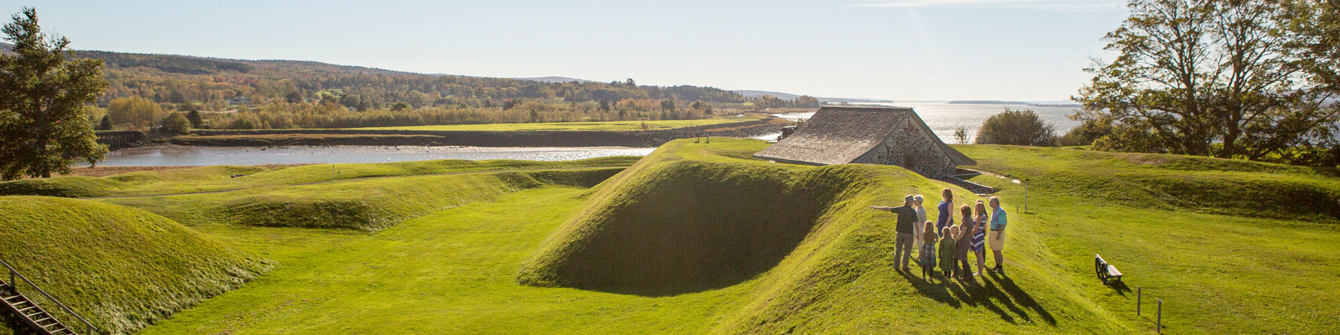
Stroll inside the fort and around the Perimeter Trail to discover four hundred years of history here at Fort Anne in Annapolis Royal. Walk the earthen walls, explore the 1797 Officers’ Quarters Museum, and soak up thousands of years of the region’s history.
Plan to spend a minimum of two hours to get to know the full scale of the fort. Spend an entire day to experience the exhibits, have a leisurely tour of the grounds, enjoy a picnic, and visit nearby attractions.
The story of Canada’s oldest national historic site
The booklet "Capitol, Colony and Bastion: The story of Fort Anne National Historic Site, Canada’s Oldest National Historic Site" is a great self-guiding resource and is available for purchase at the Officers' Quarters.
Map
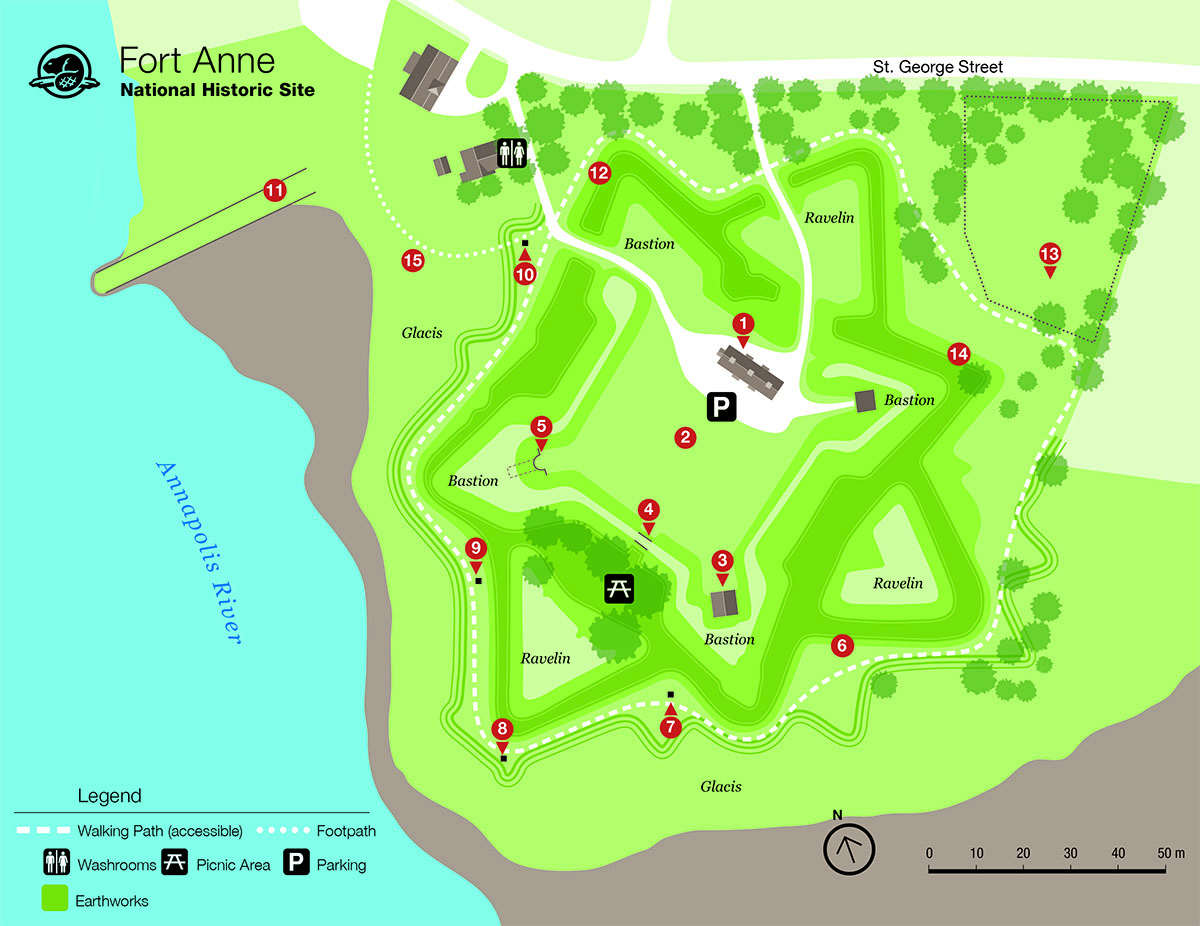
Text version
This map shows the features of interest and facilities and services at Fort Anne National Historic Site.
Legend
![]() Parking
Parking
![]() Washrooms
Washrooms
![]() Picnic area
Picnic area
 Walking path
 Footpath
 Earthworks
Parking
Parking is available next to the Officers' Quarters Museum.
The parking lot surface is made of compacted dirt and gravel and is wheelchair accessible.
Washrooms
Washrooms are available in the administration building at the end of the exit road when the museum is open.
The walking distance is about a 100 m walk from the Officers’ Quarters Museum to the washroom building. The road surface is made of compacted dirt and gravel.
Picnic areas
Visitors may lay down a blanket and picnic anywhere on the grounds.
There are picnic tables available across the parade square from the Officers’ Quarters Museum and through the sally port. The picnic tables are in the shade under some large trees.
This picnic table area is grass-covered and not wheelchair accessible. There are some picnic tables that may be accessible by all-terrain wheelchair.
Walking path (Perimeter Trail)
The path around the perimeter of the fort is approximately 1 km long and 3 feet wide. The path surface is made of compacted crushed stone and is wheelchair accessible.
Footpath
The footpath is 50 metres long from the Pierre Dugua, Sieur de Mons monument to where it joins up with the Town of Annapolis's waterfront boardwalk. The path surface is made of compacted crushed stone and is wheelchair accessible.
Earthworks
The fort is surround by steep, grass-covered earthworks. Earthworks are large artificial banks of soil used to protect the fort.
The earthworks are not wheelchair accessible, but some sections may be accessible by all-terrain wheelchairs.
Features of interest
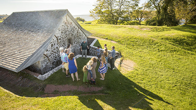
1. Officers’ Quarters Museum
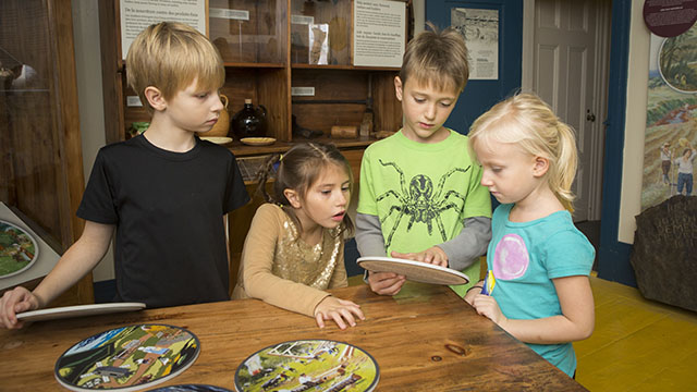
Immerse yourself in the history of the region inside the Officers’ Quarters Museum. Use innovative technology to delve deeper into the social, cultural, and military stories of all peoples connected to this place, including Mi’kmaq, Scottish, French, British, Acadian, and African Nova Scotians. Explore how the site has changed over time and what it means now to the people of Annapolis Royal and Canada.
Things to see and do:
- Listen to stories about Mi’kmaq history and culture
- See a reproduction of the Nova Scotia Charter from 1621
- Dress as a French or British soldier
- See the actual key to Fort Anne
- Learn about the Covenant Chain of Treaties at the Treaties table
- See the incredible Fort Anne Heritage Tapestry
- See a selection of artifacts found on site
2. Parade Square
The open space in front of the Officers' Quarters is called the Parade Square.
Signs around the perimeter show where some of the buildings were when the fort was garrisoned, including a store house, the governor's residence, barracks site, and the chapel site.
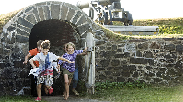
3. Powder Magazine
Look inside Parks Canada’s oldest building!
In the south corner of the Parade Square is a restored Powder Magazine, originally constructed by the French in 1708.
There are barrels stacked on one side, and a cool draft comes through slotted openings to keep the powder dry. The slots were also designed to keep out sparks and flames, which would have ignited the whole supply.
The walls are much thicker than the roof, which is actually designed to blow outward, making it easier for the walls to absorb the impact. In the event of an explosion, damage to the fort is minimal.
4. Sally port
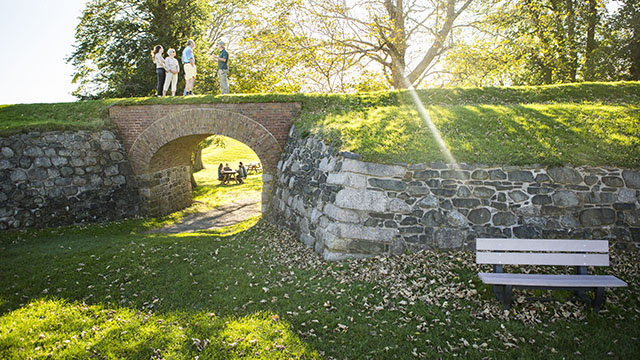
The sally port is located along the southwest side of the Parade Square. This entrance into the fort grounds was used by the British, while the French had a bridge here earlier.
Many popular pictures of the Officers’ Quarters were taken through this opening.
5. Black Hole
In the far corner of the Parade Square is another structure known as the Black Hole. This powder magazine was built into the west bastion by the French.
After 1740, it was abandoned as a magazine because of chronic dampness, and was used sporadically as a prison by the British.
6. Earthworks
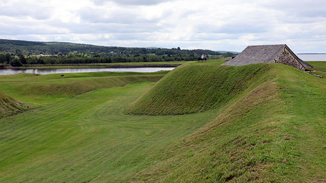
The Earthworks have some of the most striking features of the fort, and contain the best surviving example in North America of a Vauban fort.
Vauban (1633-1707) was a French military engineer. A Vauban fort is essentially a star shaped fort.
The four projecting corners are called bastions and the triangle of earth in front of the walls are ravelins. This allowed for protection on all flanks.
The fort is surrounded by a dry moat with very steep banks, followed by the glacis, an open sloping area also surrounding the fort. The glacis was intended to make secret approaches by enemies impossible.
The earthworks are not wheelchair accessible, but some sections may be accessible by all-terrain wheelchairs.
7. Jean Paul Mascarene Monument
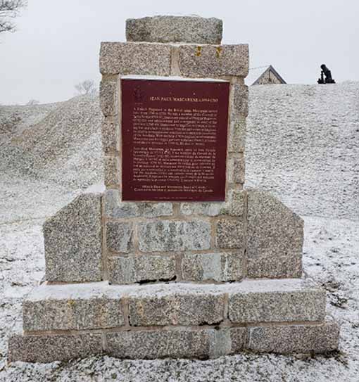
Jean Paul Mascarene’s efforts and influence on this area were of such importance that the fruits of his labour are reflected in the community, and all of Acadia, to this day.
Historic Sites and Monuments Board of Canada:
JEAN PAUL MASCARENE c.1694-1760
A French Hugenot in the British army, Mascarene served here from 1710 to 1750. He was a member of the Council of Nova Scotia (1710-1750), lieutenant-colonel of Philipps’ Regiment (1742-50), and administrator and commander-in-chief of the province (1742-49).
Hampered by insufficient troops, a decaying fort, and a lack of guidance from the authorities in England, he tried by persuasion and conciliation to ensure the neutrality of the Acadians.
With the help of New England reinforcements, Mascarene and his ragged garrison withstood French attempts to retake the province in 1744-46.
He died in Boston.
8. Charles Fort and d’Aulnay Monument
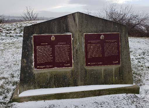
Forts under forts under forts. Stand where the first and second forts were built on these grounds. Washed away and buried by progress, archeological remnants still exist below the surface.
Plaque Text
CHARLES FORT
A group of about 70 Scottish settlers began a colony here in 1629, eight years after King James I granted 'Nova Scotia' to Sir William Alexander. Led by Alexander's son, the Scots built a small fort, the remains of which lie beneath Fort Anne. Despite many deaths during the first winter, the surviving colonists thrived on agriculture, fishing, and trade with the Mi'kmaq. Most returned to Great Britain in 1632 after France reacquired the region by treaty. Although the colonization attempt was short-lived, the province of Nova Scotia owes its name, flag, and coat of arms to this early Scottish settlement.
Plaque Text
CHARLES DE MENOU D'AULNAY (v. 1604-1650)
This eminent sea captain played a key role in the settlement of Acadia. He commanded La Hève and Port Royal in 1636, and became governor of Acadia in 1647. Over a fourteen-year period, he oversaw the construction of forts, mills and schools and ventured into shipbuilding. He drained marshes with a system of dykes and tide gates, enabling settlers to survive through agriculture. Charles de Menou d'Aulnay was one of the great architects of French settlement in Canada.
9. Samuel Vetch Monument
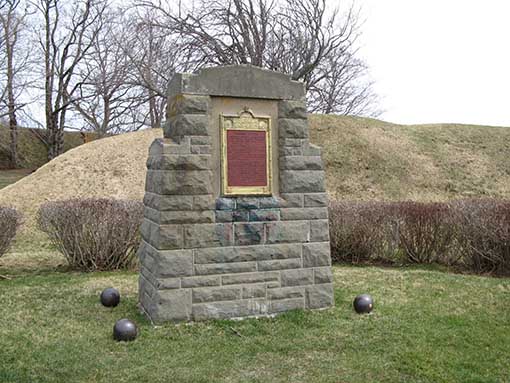
Samuel Vetch was a man of great importance to the history of Fort Anne, Nova Scotia, and the expansion of the British Empire.
Monument:
SAMUEL VETCH
Adjutant-General of the force under Colonel Francis Nicholson, which captured Port Royal, Capital of Acadia, in 1710.
First Governor and Commander-in-chief. A notable figure in colonial history. An able soldier and administrator.
With Imperial vision he strove to extend the realm of Britain beyond the seas.
Erected 1928
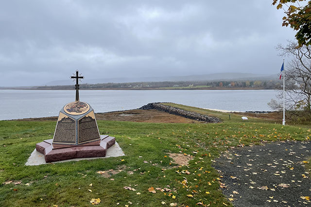
10. Pierre Dugua, Sieur de Mons Monument
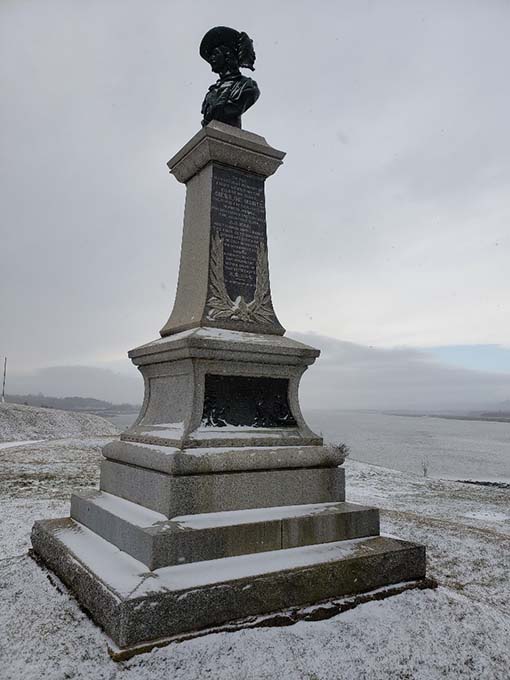
Pierre Dugua, Sieur de Mons is an often overlooked giant in European exploration and settlement of North America. The text is dated and very Eurocentric, but the monument is a testament to a man of great importance nonetheless.
Pierre Dugua led the French expedition that created the first permanent European settlement in North America north of St. Augustine, Florida – in what was to become Canada. He also helped to establish a relationship with the Mi’kmaq that would influence events in the Maritimes for decades to come.
Monument:
To the illustrious memory of Lieut. Gen’l Timothé Pierre du Guast, Sieur de Monts, the pioneer of civilization in North America, who discovered and explored the adjacent river, A.D. 1604, and founded on it’s banks the first settlement of Europeans north of the Gulf of Mexico. The Government of Canada reverently dedicates this monument within sight of that settlement, A.D. 1904.
Genus immortale manet
11. Queen’s Wharf
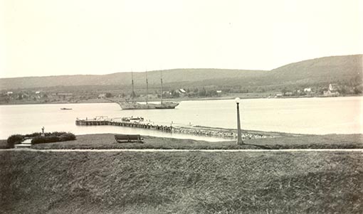
The wharf was used by both the French and British when occupying the fort.
Walk on the last piece of land that many Acadians set foot on before being deported in 1755.
Sit in the red chairs and take in the timeless view.
12. Perimeter Trail
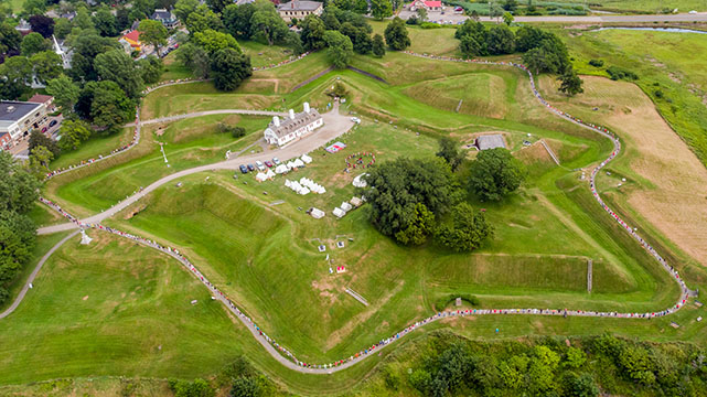
The best way to see the Earthworks (#6) is to walk around the Perimeter Trail that circles the fort.
Experience the full scope of the grounds and enjoy an excellent view of the Annapolis River and basin all the way to Digby, approximately 24 kilometres away!
The path around the perimeter of the fort is approximately 1 km long and 3 feet wide. The path surface is made of compacted crushed stone and is wheelchair accessible.
13. Fort Anne cemeteries
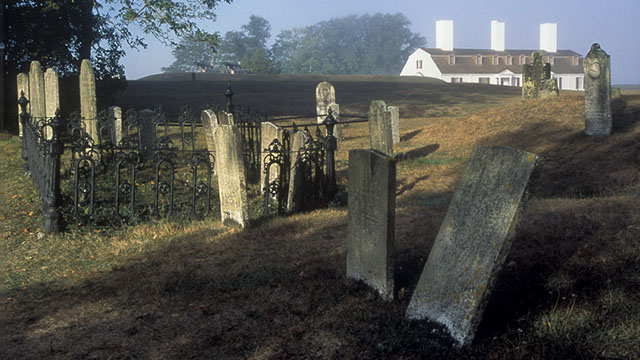
The Acadian and French Cemetery and the Garrison Graveyard served as the final resting place of Acadians, British citizens, French and British soldiers, and diplomats that lived in Annapolis Royal over the past 350 years.
Some of the oldest grave markers in Canada are found here, and remember, there are many more burials here that are far older than the stones.
Things to see and do:
Candlelight graveyard tour
Join a guided tour presented by The Historical Association of Annapolis Royal.
What Lies Beneath: An ArcGIS StoryMap
"What Lies Beneath" is an Acadian ancestry project by MAPANNAPOLIS in partnership with Boreas Heritage Consulting and Parks Canada.
14. Cold case burial site
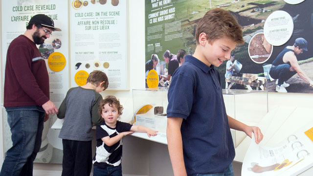
The final resting place of an 18th century soldier whose remains were found on the shore, just below the fort walls.
Visit the Discovery Room in the Officers’ Quarters Museum to uncover the soldier’s identity!
15. Acadian Odyssey Monument
Annapolis Royal was the second largest deportation site of Acadians (1,664 people) during the Great Upheaval in 1755.
For many Acadians, the Queen’s Wharf was the last piece of land they set foot on in Acadia.
Plaque text
PORT-ROYAL, CRADLE OF ACADIE
Established in Mi’kma’ki, the homeland of the Mi’kmaq, in 1605, Port-Royal was the first permanent European settlement in what is today Canada. It was the cradle of Acadie from which settlers spread to other settlements such as Beaubassin, Grand-Pré, Rivière-aux-Canards, Pisiquid and Cobequid.
In 1755, Port-Royal (renamed Annapolis Royal in 1710) had a population of 2,300 Acadians living in about 30 villages with the support of the Mi’kmaq on both sides of the basin and the Dauphin (now Annapolis) River. They created rich farmland by draining the marshes of their salt content with a system of dykes and aboiteaux.
Some villages had descriptive names like Pré-Ronde, Loups-marins, Beaulieu and Belle-Isle. Others were named after a family like Melanson or a nickname like La Rosette.
On December 8, 1755, 1,664 Acadians from Port-Royal were deported by ship to the Anglo-American colonies. One group of deportees managed to take hold of their ship (the Pembroke) and diverted it to the Saint John River. Hundreds of other Acadians from Port-Royal, thanks to their natural and sustained Acadian-Mi’kmaq relationships, also escaped deportation and stayed in Acadie. Some of them eventually settled in the Memramcook area and along Saint Mary’s Bay after after 1763.
None of the Acadians who had been deported or chased from the Port-Royal region returned there permanently. Most settled in Québec. Some came back to Acadie and settled in Saint Mary’s Bay and Sainte-Anne-du-Ruisseau while others settled in Louisiana.
Honour and gratitude to the first Acadian families!
- Date modified :