
History of Sloop Cove
Prince of Wales Fort National Historic Site
Sloop Cove was identified as Nationally Significant because of the inscriptions left there by the men who lived at the Fort and worked with the boats used by the Hudson's Bay Company.
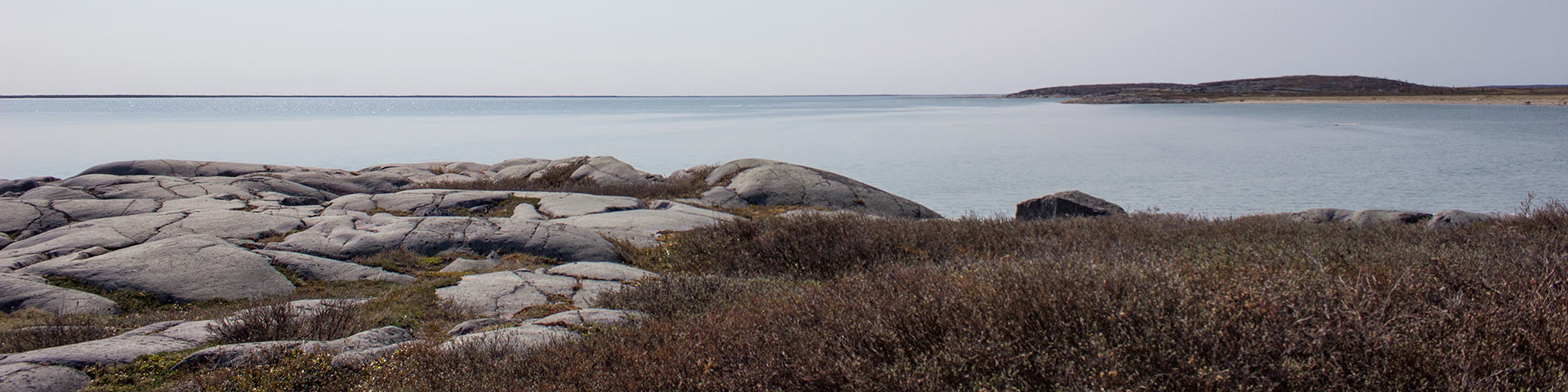
Sloop Cove is a sheltered nook situated 3.2 kilometres from Prince of Wales Fort on the west side of the Churchill River. Sloops were wooden sailing vessels used during the fur trade for exploration, whaling expeditions and northern trading attempts with the Inuit. During the 1700s, there was 3.2 metres of water in the cove at high tide, so it was an ideal wintering and mooring spot for them. Iron rings,which were driven into the rocks by the Hudson's Bay Company men to secure the sloops, are still visible today. They brought supplies and long-awaited mail for the Hudson's Bay Company men who lived at Prince of Wales Fort. Ships from England wintered in the cove as early as 1689.
The south accesses the Churchill River in two spots, one between the west wall and a rock outcrop island in the centre of the cove; the other between the island and a man made breakwater to the east.
For many years it was thought that the dry cove was a result of the phenomenon known as isostatic rebound. This situation describes the gradual rising of land elevations as it springs back after thousands of years of being crushed under the weight of continental glaciers. The west coast of Hudson Bay is known as one of the more dramatic areas of isostatic rebound where the land still rises at a rate of a meter per century. This is especially noticeable in the flat lowland areas of the coast. However, at Sloop Cove, mooring ships in 1750 would have involved a situation where the daily water level was, at most, less than 3 m higher than today. This situation would have resulted in a large pool in the cove where the Centre was about 1 m deep and most of the pool was 50 centimetres or less - hardly enough for the boat mooring. However, even at an increase of only 2 m, the cove becomes an almost perfect dry dock. At high tide, there is enough water to easily drag the boat into the mouth of the cove and past the breakwater and natural island. Then the boat can be manhandled through a shallow, salt water pond to the location desired. Once into the cove, there is little chance of damage from ice or storms.
There has been no analysis of how Sloop Cove was used by the 18th-century inhabitants of the area, but there are several indications that help us understand at least part of the picture. First of all, the site is a wintering cove for the sloops that over wintered in the bay and possibly a place for larger, ocean going ships to put in for repairs. Virtually all of the inscriptions are from seamen or shipwrights so the area was probably of little use except as shelter for the boats. It has been assumed that the boats were floated into the cove at a time when the ocean was 2 or more meters higher and that the dry cove is a result of isostatic rebound. This seems unlikely. The number and location of the many mooring rings would suggest that the boats were hauled into the cove with block and tackle to rest in the small depression in the center of the cove. The raised beach ridge in front may have been dug out each season to make the hauling easier. There may also have been a somewhat deeper central pond but it is unlikely that any boats with a draft of a metre or more floated into the cove.
If repairs were needed below the waterline or if barnacles were to be removed, the boat would then have to be hauled to one side or to the back of the cove to bring it out of the water. In the absence of any concrete evidence, alternative explanations are equally plausible.
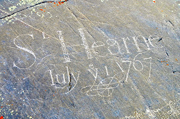
The lichen covered rocks bear the names carved into the stone by the Company men. They were sailors, harpooners, shipwrights, carpenters, shipmates, captains, labourers and a servant. The name most visitors recognize is that of Samuel Hearne.

© Parks Canada/ PWF Collection
Samuel Hearne
Samuel Hearne was 22 years old when he carved his name at Sloop Cove. He was employed by the Hudson's Bay Company as a shipmate. He journeyed to the Coppermine River with the help of Mattonnabbee and his wives, a trip which took 18 months. Mattonnabbee was a leading Indigenous person who had great prestige among the Chipewyans and the Athabascan Cree. He had developed an organized pattern of movement between the trade posts on the coast and the interior. In 1774, Hearne established the first inland trading post, Cumberland House, and was governor at Prince of Wales Fort from 1775 to 1782. After the French destroyed the fort in 1782, Hearne returned to establish Fort Churchill 8 km upriver from Prince of Wales Fort. Read about Samuel Hearne in his own words: Arctic Dawn: The Journeys of Samuel Hearne.
- Date modified :