
Mount Decoeli Route
Kluane National Park and Reserve
Distance: 18 km (11 mi) return trip
Time: 7 - 11 hours
Elevation gain: 1,332 M (4,370')
Maximum elevation: 2,330 M (7,644')
Trailhead: 20 km (12.5 mi) north of Haines Junction on the Alaska Highway, 2.2 km (1.4 mi) north of the Spruce Beetle Trailhead
Topo map: Kloo Lake 115A/13
In summary
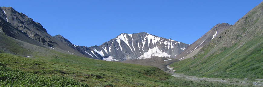
The ascent of Mt Decoeli is a long strenuous day hike. Alternative options include a day exploration of the rock glacier or pass between Mt Decoeli and the unnamed peak to the southwest. The climb is not technical but a section near the summit is quite steep with some loose rock (the last 240 meters).
This route offers ample opportunity to see wildlife including hoary marmots, Dall sheep, golden eagles, and the occasional wolverine and grizzly bear. Views from the rock glacier, pass, and summit are exceptional. From the summit, on a clear day some of the highest peaks of the ice fields range can be seen including Mt. Logan, Mt. Vancouver, Mt. Kennedy, Mt. Hubbard, Mt. Alverstone, and Weisshorn. The headwalls above the rock glacier and the abundance of wildflowers make even a cloudy day in the area an inspiring adventure. Mt. Decoeli offer views into the Shakwak valley to the east half way to Whitehorse, south to Dezadeash Lake, and northwest as far as the branching arms on Kluane Lake.
The route described here is not within the boundaries of Kluane National Park and Reserve.
Download the Mount Decoeli Route description (PDF, 180 Kb)A route is not a trail
Routes are not marked with signs or maintained in any manner. The route described here is only a suggestion that may help guide you on your trip. Self-reliance and wilderness travel experience are essential, including excellent route finding skills, map and compass skills. It is the responsibility of individual hikers who choose to follow such routes to adequately prepare and be prepared to rely on themselves.
The details
The route begins from a parking area on the west side of the highway just 2.2 km north of the Spruce Beetle Trailhead. Park in the parking lot and walk south along the west side of the highway for a short while. You will see flagging tape and a rock cairn that mark the start of the route. Follow this trail for 1 km to Summit Creek. Here you will start following the creek bed up towards the rock glacier.
The route follows the creek staying on the south (left hand) side on the lower section with occasional shortcuts along dried up stream channels. You may choose to cross the creek occasionally, however during high water it may be best to remain on the south (left) side of the creek, and cross the creek at the base of the rock glacier. It is also possible to walk along the alpine ridge to the south of the creek bed to avoid the creek altogether until you reach the rock glacier.
The easiest way up Mt. Decoeli is from the south-southwest. Many people attempt to climb straight towards the peak from the toe of the rock glacier, this route is steeper than it appears, very exposed and is not recommended.
On the north (right) side of the rock glacier and the creek, you can access a grassy slope where a well-used trail will take you up and along the base of Mt Decoeli. This meadow is also the home of a colony of hoary marmots. Continue along the meadow and drop back down to Summit Creek where the meadow stops and you can see a drainage with a temporary creek to your right (north). Although this looks like the quickest way to the ridge of Mt Decoeli, it is much easier and faster to continue up Summit Creek, go around a lighter coloured rocky slope to your right and start heading up to the pass once you are around the corner.
Go to the ridge and then venture right (east) up to the summit of Mt. Decoeli. It is best to stay on this side of the mountain as the east and south facing slopes are very steep with loose rock.
What you need to know
Good boots are a must for hiking on the loose rock sections and the boulders along the creek. You may want to take 1-2 litres of water with you, especially on a hot day. Binoculars or a spotting scope are very useful for wildlife viewing and for observing distant mountains.
Bear sightings are common in this area. Review recommendations for travel in the You Are In Bear Country brochure. Please report all bear sightings to the staff at the Kluane National Park and Reserve Visitor Centre in Haines Junction or at the Thachäl Dhäl Visitor Centre.
Using topographic a map at a 1:50,000 scale is highly recommended: Kloo Lake 115 A/13
Parks Canada 24 hour emergency dispatch
1-780-852-3100
Cellular telephones do not work in most of the park. Satellite phones or satellite messaging devices are strongly recommended.
Related links
- Date modified :