
Dän Zhùr (Donjek) Route
Kluane National Park and Reserve
Distance: 110 km (68 mi) loop
Time: 8-10 days
Elevation gain: 3,600 m (11,811’)
Maximum elevation: 2,170 m (7,120’)
Trailhead: 700 m (2,300’) north of the Duke River Bridge, 9.5 km (6 mi) north of Burwash Landing on the Alaska Highway.
Topo maps: Bighorn Creek 115 G/3, Donjek Glacier 115 G/4, Steele Creek 115 G/5, Duke River 115 G/6, Burwash Landing 115 G/7
In summary
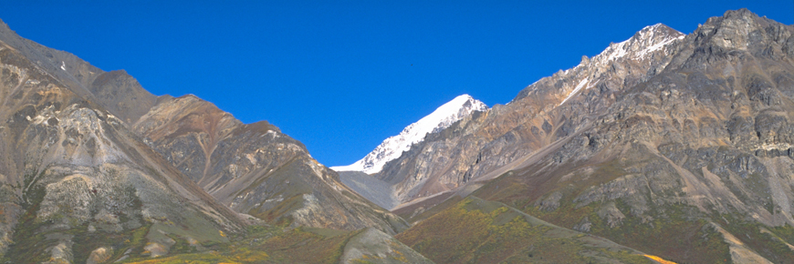
One of the most popular hikes for wilderness enthusiasts is the Donjek Route. Rising over the vast alpine of the Burwash Uplands and then descending to the toe of the Donjek Glacier, this hike typifies "pristine mountain wilderness".
Download the Dän Zhùr (Donjek) Route description (PDF, 175 Kb)
A route is not a trail
Routes are not marked with signs or maintained in any manner. The route described here is only a suggestion that may help guide you on your trip. Self-reliance and wilderness travel experience are essential, including excellent route finding skills, map and compass skills. It is the responsibility of individual hikers who choose to follow such routes to adequately prepare and be prepared to rely on themselves.The details
This route is a recommended 8 - 10 day trip that starts where the Duke River meets the Alaska Highway. It then travels southwest over Hoge Pass to the Donjek River before turning southeast past the Donjek glacier to Bighorn Creek. From this point the route turns northeast rising over Atlas pass then continuing on to the Duke River and finally following Copper Joe Creek (still marked as Halfbreed Creek on some maps) out to the Highway. The estimated map distance from where the Alaska Highway crosses the Duke River, to where Copper Joe Creek meets the highway, via the following described route, is approximately 100-120 km. About ½ of this route is outside the park boundaries. The route follows creek and river drainage for the most part with some sections along an old road, horse and wildlife trails, and some sections, without any obvious trail at all. Route finding abilities and solid wilderness experience is essential for this route.
Using topographic maps at a 1:50,000 scale is highly recommended.
Route segments
-
Burwash Uplands
The route begins about 28 kilometres from the park boundary at the Duke River, 9.5 kilometres north of Burwash Landing. After crossing the Duke River bridge, turn left onto a narrow gravel road. This is an old mining road that you may be able to drive on for about 5 km depending on your vehicle and road conditions. This road is not within the park. Access is subject to change due to mining activity and road conditions. Travel at your own risk.
Approximately 5.1 km down the old mining road (from where you turned off the highway), a few older cabin-style buildings appear on your right. This is a horse camp. Just after the horse camp, the road forks (UTM 07 V 597900E 6802200N). It is a good idea to leave your vehicle in this area and continue on foot.
Taking the right fork, follow the road uphill; you will pass debris from recent mining activity on your left and a portable white trailer on your right. Another 1.5 km up the road, you will arrive at a second junction (UTM 07 V 596900E 6802900N); follow the road to the left. The trail continues climbing through the trees for 3.3 km, passing a lake and a couple of small creeks before reaching the subalpine.
After walking for a couple of kilometres in the subalpine, you will reach an area where the old mining road is severely eroding (sloughing off) into small ponds that exist on either side of the old mining road. The mining road continues for a further 3 km across the hummocky tundra and crosses a creek (at UTM 07 V 591300E 6802000N). The large flat open area on the north side of this creek provides a comfortable camping spot.
It is a good idea, particularly under wet conditions, to continue along the main mining road as far as you can before heading towards Hoge Pass. If conditions are dry, you might choose to cut across the hummocky tundra before the main mining road disappears, but this involves some up-and-down travel over steeper terrain. This is a section of the route where you will need to judge, which is the best route to take, based on the conditions you encounter.
If you stick to the main mining road, in about 3.5 km you’ll reach a junction (UTM 07 V 588400E 6803300N) where another road heads straight south towards Amphitheatre Mountain. It is generally advisable not to turn down this road, but to continue along the main mining road for another 1.8 km, at which point the road virtually disappears (UTM 07 V 586700E 6803300N). From this point, head west (left), aiming for a low saddle on the northwest end of Amphitheatre Mountain. From where you leave the road, it is about6 km over the hummocky tundra to Burwash Creek. There are suitable camping areas on the west side of Burwash Creek, a couple of kilometres upstream from where you descend to the creek. The park boundary (UTM 07 V 583200E 6798100N) is a little further on. A warden patrol cabin is situated at the base of a rock outcrop just over 1 km upstream from the park boundary.
-
Hoge Pass
The route continues along Burwash Creek. About 1 km past the warden cabin, a creek enters Burwash Creek from the west (UTM 07 V 582300E 6796800N); an old mining road runs above this creek. Follow this road for about 2 km west to Hoge Pass. Once at the top of the creek, do not follow the creek down although it seems to be the obvious route. Rather, gradually climb up the ridges to the south (left). Once up on the ridges continue southwest, staying to the west on the ridges, as far as possible. Drop down a scree slope to the left. Once in the grass gully, follow it down veering to the left. Don't take the first gully down but stay left until you come to a very steep canyon. Here you will find a scree slope you can hike down to get to a small creek that empties into Hoge Creek. From the correct descending point you will be able to see both the small creek and Hoge Creek as well as the route down. It is about 10 km from the top of Hoge Pass to the Donjek River.
There are several gullies heading down to Hoge Creek. They are all tricky and steep with a lot of loose scree and rocks. Choose your route carefully because some gullies are dangerous and impassable. Follow Hoge Creek to the Donjek River. The creek will be high and numerous crossings will be required.
-
Donjek River and Glacier
Depending on the flow of the Donjek River, it may be possible to walk in the valley bottom along its east side to a point where the river comes up against high cliffs. If you choose this route, just before you reach the cliffs, start hiking east up the slope away from the river (perpendicular to the river) toward the mountains. After 30-45 minutes of bushwhacking you will meet a well-defined trail (an old horse trail).
When the Donjek is running along the east side of the valley, an alternate route may be taken to reach the horse trail. To follow this alternate route, look for well-used game trails a couple of hundred metres downstream from the old horse camp located on the south side of Hoge Creek (near UTM 07 V 575100E 6794900N). Follow the game trails to the more prominent horse trail.
Once you are on the horse trail, follow it as it crosses a couple of small creeks and opens into a meadow (at UTM 07 V 575600E 6792500N). The trail crosses a creek bed of pink coloured rock 2.5 km further on (near UTM 07 V 576800E 6791200N). It then enters a balsam grove, and enters a creek with clear water (at UTM 07 V 578000E 6790400N). The horse trail continues through thicker shrubs for nearly 2 km before coming to a larger creek (at UTM 07 V 580300E 6788800N). It is possible to camp near this creek just upslope from the trail near the cut bank.
One kilometre further on, the trail enters a small meadow that has a running stream. Over the next 3 kilometres, you will cross a few more creek beds, after which the trail opens in a larger meadow (UTM 07 V 581700E 6786300N), also with a running stream. This meadow is closer to the Donjek, and the hills in front of the toe of the glacier make for nice walking and great views of the glacier. Follow the easiest route until you arrive at cliffs above Bighhorn Creek. Look for the distinctive gully that provides an easy route through the cliffs to creek level.
-
Bighorn Creek
Proceed upstream along the north side of the creek until the creek is visible within the canyon. At this point, you must decide whether to stay along the creek or find a convenient route up the steep slopes to the north. If you decide to travel through the canyon you may find you have to cross the main channel of the creek a number of times. If the creek is high, it is recommended to bypass the canyon by heading north, up roughly 400', and then contouring east to a convenient slope that drops down on the tributary (Chert Creek) of Bighorn flowing from the north. At low water levels, walking through the canyon will take less than an hour, while taking the canyon bypass may take as long as 3 hours.
Another alternative if the creek is running high is to hike to Atlas Pass via Expectation Pass. This route (which is described by V. Lougheed in The Kluane National Park Hiking Guide ) offers stunning views of the Donjek and some of the bigger peaks in the icefields. The elevation gain along this alternative route is steady, but the contouring is easy.
-
Chert Creek
The next stage of the route involves following the tributary of Bighorn (Chert Creek), which flows in from the north by north east. About 2 km up, the creek branches. Follow the right (east) side. 600 m past the fork is a second fork (you will pass a small creek before the second fork, do not mistake this for the second fork!). From the second fork a waterfall may be visible (depending on water levels) on the right side. It is easiest to bypass by following the left fork (west) 300 500 m until a climbable slope appears on the right (east) side. After a short, steep climb you will emerge in sub alpine area and a good place to camp (UTM 07 V 591300E 6782600N).
An alternate route to bypass the waterfall is to climb high on the grassy slopes of the east side of the creek but it is steeper and you have to climb higher than on the left (west) side. Just a bit above the falls the creek forks again. The area between the two forks is a flat, excellent, slightly overused campsite.
-
Atlas Pass
The route follows the left fork tributary to its source just before the top of Atlas Pass (6900') (at UTM 07 V 593100E 6785300N). It is very easy to travel up off the creek drainage, between the falls and the top of the pass, into the alpine and there are numerous places to camp.
Once you reach the top of Atlas Pass the view is stunning and a little overwhelming (provided you aren't immersed in cloud). Simply going straight down the most direct route off the pass is neither inviting nor recommended. The easiest route is to head to the left (north) side of the pass and climb up a bit toward some rock outcrops along the ridge (there is a small outcrop of rock that you will pass, continue up to the larger outcrop above this one). It is then relatively easy to contour along the base of the outcrop and over to a broad sloping ridge (about 150m long) composed of silt and scree. This material gives way under foot and provides a comfortable route down (and a more difficult route up). Directly down the slope you see a knoll along the ridge, off a bit to the left. Beyond this knoll there is a small saddle and then the ridge levels off and rises slightly before dropping off to the creek. Stay to the left side of the rising ridge and watch down‑slope to the left for "A Hole #9" (a distinct, flat, green patch visible on the top of a little knoll that resembles a putting green on a golf course). The best route down is the drainage just right (east) of Hole #9. Once you are down on the creek it is just a matter of following the water to where it flows into the Duke River, about 6 easy km downstream.
An alternative route description for reaching the Duke River from Atlas Pass can also be found in V. Lougheed’s The Kluane National Park Hiking Guide .
-
Duke River
Just before you reach the Duke River you will see a game trail leave the creek bed on the right. After 200 300 m along the trail it is possible to head left towards the river and find some good places to camp at UTM 07 V 596400E 6789500N.
From this point, proceed upstream along the south (right) side of the Duke River. Hiking on numerous game trails and old gravel river drainage. Just over 4 km along the river you will arrive at small creek, in a big drainage, which flows into the Duke from the south. Along the east shore of the creek, 100 m upstream from the river, there is evidence of old and new campsites alike. Continue along the Duke for about 1 km until the river begins to braid out and look for a place to cross (if water levels are high you may have to go upstream and cross Grizzly Creek before finding an area shallow enough to cross). Once across the river follow game trails and gravel washes for another 3 4 km.
-
Cache Lake
Where to turn up, away from the Duke River is not that obvious. As you travel along the river, the vegetation on the left (north) begins to thin out into an open terrace covered in Dryas (mountain avens). From this terrace head northeast to the edge of the vegetation and right away there is a dry creek wash evident and emerging in a small steep fan from the bank. Continue east past this fan until you hit the next dry fan. As you head north up the wash (about 100-300 m) you will find a small path that was once a road. This path can be difficult to find and the creek is small. If you find yourself standing across from Grizzly Creek you have gone too far and missed the path. Retrace your steps and eventually you will find the path. You can easily follow this path up over a low pass to Cache Lake where you will find another excellent camping spot at UTM 07 V 604300E 6787600N.
When looking at a map, you can see that there is an alternative way to reach Cache Lake, by ascending the first creek (it may appear as a dry creek bed) southeast of Cache Lake. Walk through the trees and continue along the creek bed for about 2 kilometres. Just past the knoll at UTM 07 V 605100E 6785900N, exit the creek bed up and to the left (northwest). Continue northwest towards Cache Lake. You will pass another small lake on your left, and the walking is pleasant and provides great views. It is an easy walk down to Cache Lake, and the old road can be located on the west side of the lake.
-
Copper Joe Creek (Halfbreed Creek on some maps)
The remainder of the route follows the drainage of Copper Joe Creek. At some points there is evidence of an old road, but in many places it has been washed away. In most cases the remains of the road are found on the east (right) side of the creek and as a result it is often easier to travel on that side, but you may find it necessary to cross. You will cross the park boundary again about 15 km before the Alaska Highway. The road improves substantially 4 or 5 km before you arrive at the highway and it is an easy end to the trip.
What you need to know
Unfortunately, cases of giardia have been reported in Kluane, so water boiling, tablets or filters are recommended.
Good boots are necessary when climbing scree and gaiters are also handy for keeping the water, rocks and snow out.
Depending on the year, this route is generally snow free from around mid-June to mid-September. Although unusual, it is possible to get snow on the passes on any day of the summer.
Some commercial companies guide groups over this route, so do not be surprised to see other people in the middle of nowhere. However, some times of year it will be unusual to see someone else on the whole hike.
For all overnight trips in the park Approved Bear Resistant Food Canisters are mandatory and a Wilderness Permit is required, both can be obtained from the Kluane National Park and Reserve Visitor Centre in Haines Junction or at the Thechàl Dhâl Visitor Centre. For more information: Overnight Registration
Bear sightings are common in this area. Review recommendations for travel in the You Are In Bear Country brochure. All bear sightings should be reported to the staff at one of the Visitor Centres.
Parks Canada 24 hour emergency dispatch
1-780-852-3100
Cellular telephones do not work in most of the park. Satellite phones or satellite messaging devices are strongly recommended.
Related links
- Date modified :