
Ä’äy Chù (Slim’s River) East Route
Kluane National Park and Reserve
Distance: 46 km (28 mi) return trip
Time: 2 - 4 days
Elevation gain: 91 m (299')
Maximum elevation: 1,680 m (5,500')
Trailhead: 2.8 (1.7 mi) km south of the Thechàl Dhâl Visitor Centre, (67.5 km (42 mi) north of Haines Junction) on the Alaska Highway.
Topo map: Slims River 115 B/15
In summary
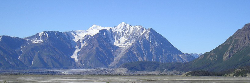
The Ä’äy Chù (Slim's River) East route follows the East shore of the Ä’äy Chù (Slim's River) Valley to the toe of the Kaskawulsh glacier. Note that this route follows a decommissioned trail – it is not maintained anymore. As you will see in the description, the old trail is in varying shape, depending on where you are. The elevation gain occurs mainly at the end of the route, for those who decide to climb up the ridge to get a view of the glacier. This hike and its destination are similar to the Ä’äy Chù (Slim’s) West route but it is a bit easier.
Download the Ä’äy Chù East Route description (PDF, 186 Kb)
A route is not a trail
Routes are not marked with signs or maintained in any manner. The route described here is only a suggestion that may help guide you on your trip. Self-reliance and wilderness travel experience are essential, including excellent route finding skills, map and compass skills. It is the responsibility of individual hikers who choose to follow such routes to adequately prepare and be prepared to rely on themselves.
The details
After the leaving the highway and driving to the small pull-off, if the gate is open, you can drive another 3 km further on a narrow dirt road. The road is rough and requires a high clearance vehicle. Watch for a trail sign on the left and a small pull-out on the right marking the beginning of the route. If you reach the creek, you have gone too far. Try to park to the side as much as possible.
About 1.5 km along the route you will reach Vulcan Creek. It has changed course several times over the years and washed out sections of the route. Watch for rock cairns guiding the way through this area. Use caution when crossing the creek, as there will be varying amounts of water flowing depending on the weather and season.
Once across the creek try to find the old clear-cut trail. Follow this trail to an alluvial fan. There are rock cairns guiding you across the fans. However, they become sparser over time and harder to see. Also note that it can be difficult to find the route after traversing alluvial fans, so be sure to note where you exit the trees onto the fan to help you find the trail on the way back. After the forested section following Vulcan creek fan, the trail will lead you down to a swampy bog. The trail is a little hard to find in this location so look for a rusty coloured stream and large rocks and then turn sharply to the left to pick up the trail again, leading you to higher ground. It is not recommended to cross over the swamp, as there are sink holes.
The trail then crosses the end of a rock glacier. The rock glacier is still active (moving) and forested, and can be recognized by the way it is breaking off into the valley, causing cracks in the ground, and splitting trees in half from the bottom.
After the rock glacier you cross over another alluvial fan and have to find the trail on the other side. Follow the rock cairns across the fan to pick up the trail again. After another short, forested section, you come to a small pond on the right hand side. Then the trail leads through some more forest.
A good camping spot is about 15 km up the valley, near a small lake. There are other camping spots over the next 6 km. Fresh water can be scarce at certain times of the year. Camping is recommended well away from the riverside, as this is a travel corridor for wildlife. The last two km before the toe of the Kaskawulsh glacier are not recommended for camping, due to high winds and blowing silt. The last 8 km after the lake are flat and easy walking to the foot of the glacier.
There are two nice vantage points that offer views onto the glacier. The easier one is from the hill at the foot of the glacier; the other requires hiking onto a ridge on the south-east side across from the hill. You can see the south arm converging with the main glacier by hiking up this ridge. An extra day should be planned to accommodate this hike.
What you need to know
When the water level is lower, people have been known to hike along the riverbed. Remember that the English name of the river (Slim’s) refers to a horse that sank and was killed in the dangerous ‘quick mud’, so it’s best to watch where you step!
Take care when traveling through the forested sections of the trail as the riverbanks are eroding.
For all overnight trips in the park Approved Bear Resistant Food Canisters are mandatory and a Wilderness Permit is required. Both can be obtained from the Kluane National Park and Reserve Visitor Centre in Haines Junction or at the Thechàl Dhâl Visitor Centre. For more information, please refer to Overnight Registration.
Bear sightings are common in this area. Review recommendations for travel in the You Are In Bear Country brochure. All bear sightings should be reported to the staff at one of the Visitor Centres.
Parks Canada 24 hour emergency dispatch
1-780-852-3100
Cellular telephones do not work in most of the park. Satellite phones or satellite messaging devices are strongly recommended.
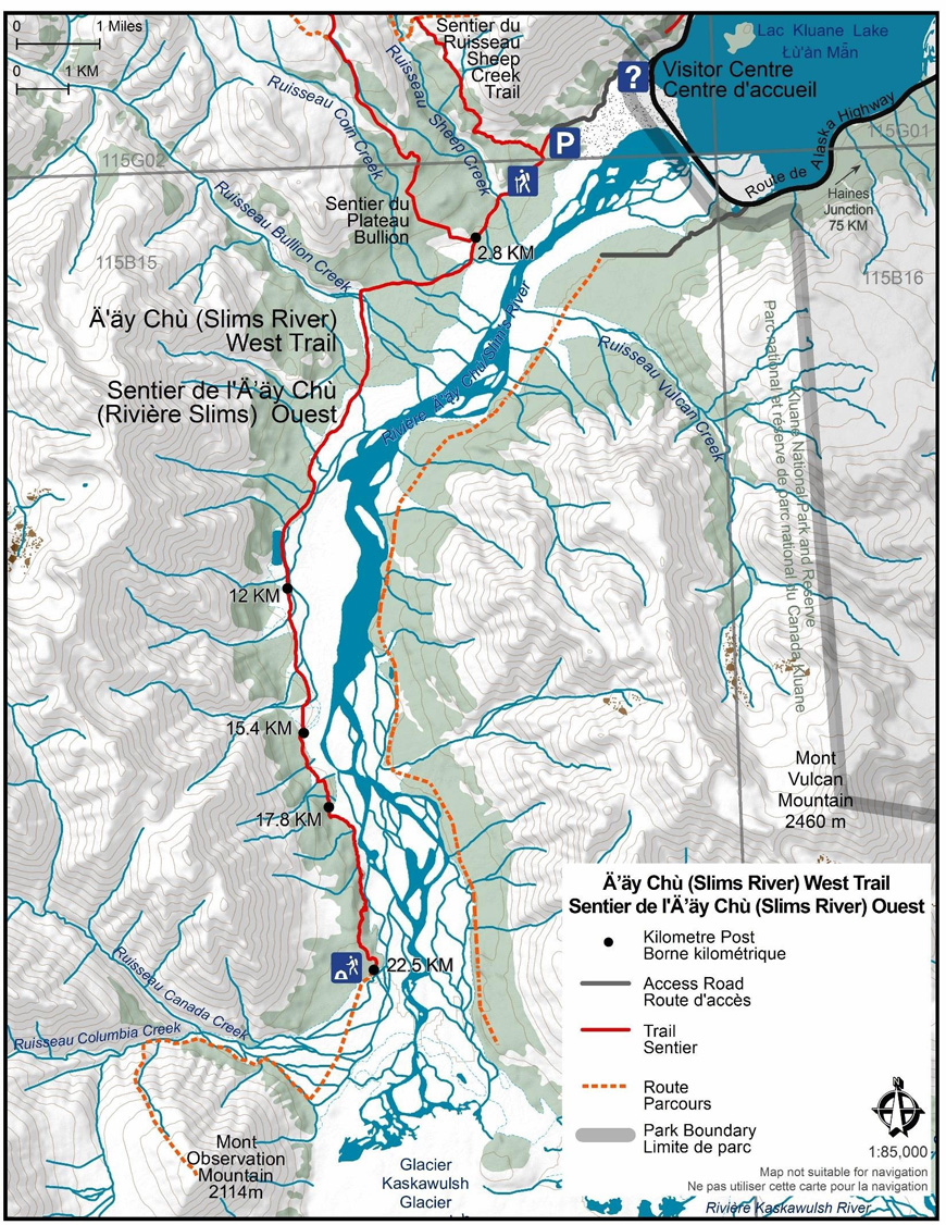
Using a topographic map at a 1:50,000 scale is highly recommended: Slim’s River / Ä’äy Chù 115 B/15
Related links
- Date modified :