
Georgian Bay Islands National Park of Canada, including Beausoleil Island National Historic Site draft management plan 2022
Georgian Bay Islands National Park
Table of contents
Executive summary
Established in 1929, Georgian Bay Islands National Park is Canada’s smallest national park. The park is located approximately 160 km north of Toronto, Ontario and is within a half day’s drive for millions of Canadians. Consisting of 50 islands and properties covering a total area of 14 km2, the park can only be accessed by boat. Visitors arrive via private watercraft, commercial operators, and the park-operated Day Tripper shuttle boat service. Beausoleil Island is both the largest and most culturally significant island within the park, and accounts for a majority of the land base.
Ecologically, the island-based park is part of the world’s largest freshwater archipelago. This area is known as the 30,000 Islands and is a core protected area of the Georgian Bay Biosphere Reserve – a United Nations Educational, Scientific and Cultural Organisation (UNESCO) designation. Interestingly, this National Park straddles two natural bioregions: the Great Lakes Precambrian Shield and St. Lawrence Lowlands.
Georgian Bay Islands National Park is located close to several First Nation and Métis communities, and is also within an area of traditional interest to others. For millennia, Beausoleil Island has been at an intersection for people traveling along the sheltered islands of Georgian Bay, and those travelling from central Ontario on what is now the Trent-Severn Waterway. This long and significant heritage of generational ties to the land led to the designation of Beausoleil Island as a National Historic Site in 2011.
The main visitor access and location of all services is Beausoleil Island. Visitors connect with the rich natural and cultural heritage of Georgian Bay Islands National Park through a wide range of activities including hiking, swimming, picnicking, canoeing, kayaking and docking opportunities, as well as overnight accommodation. The park also offers engaging programs such as interpretive presentations, Indigenous workshops, cultural activities and special events. Two YMCA camps have been operating in the park since 1919.
This management plan replaces the 2010 management plan for Georgian Bay Islands National Park. Since 2010, the park has improved overall ecological integrity through restoration programs as well as the reduction of invasive species, visitor experience by constructing a new visitor centre and comfortable overnight accommodations, capacity for day visitors through expanded Day Tripper (boat shuttle) service, park infrastructures such as docks, trails, and worked with Indigenous partners through the Cultural Advisory Circle.
The four key strategies for the ten year management plan are:
- Key Strategy 1: Managing conservation and climate change adaptation within a broader fragmented ecosystem:
This strategy focuses on positive conservation outcomes for the park and for the region through ecological resiliency, managing impacts of climate change and collaborative relationships with a range of partners. - Key Strategy 2: Enabling access and enhancing a diverse visitor experience:
This strategy aims to improve visitor experience from beginning to end. Partnerships will play a key role. - Key strategy 3: Strengthening formal Indigenous Relations — Sharing the heritage and culture:
This strategy focusses on the foundation of respect, mutual trust, tradition and communications to strengthen relationships with Indigenous communities, sharing their stories and their cultural heritage. - Key Strategy 4: Building national park awareness and community support — The invaluable treasures of the park are known:
This strategy aims to improve Georgian Bay Islands National Park and Beausoleil Island National Historic Site’s regional brand awareness and highlight their role in protection of natural and cultural resources.
1.0 Introduction
Parks Canada manages one of the finest and most extensive systems of protected natural and historic places in the world. The Agency’s mandate is to protect and present these places for the benefit and enjoyment of current and future generations. Future-oriented, strategic management of each national park, national marine conservation area, heritage canal and those national historic sites administered by Parks Canada supports the Agency’s vision:
Canada’s treasured natural and historic places will be a living legacy, connecting hearts and minds to a stronger, deeper understanding of the very essence of Canada.
The Canada National Parks Act and the Parks Canada Agency Act require Parks Canada to prepare a management plan for each national park. The Georgian Bay Islands National Park of Canada (including Beausoleil Island National Historic Site of Canada) Management Plan, once approved by the Minister responsible for Parks Canada and tabled in Parliament, ensures Parks Canada’s accountability to Canadians, outlining how park management will achieve measurable results in support of the Agency’s mandate.
Canadians, including Indigenous peoples and other partners, were involved in the preparation of the management plan, helping to shape the future direction of the national park. The plan sets clear, strategic direction for the management and operation of Georgian Bay Islands National Park by articulating a vision, key strategies and objectives. Parks Canada will report annually on progress toward achieving the plan objectives and will review the plan every ten years or sooner if required.
This plan is not an end in and of itself. Parks Canada will maintain an open dialogue on the implementation of the management plan, to ensure that it remains relevant and meaningful. The plan will serve as the focus for ongoing engagement on the management of Georgian Bay Islands National Park in years to come.
2.0 Significance of Georgian Bay Islands National Park and Beausoleil Island National Historic Site
Established in 1929, Georgian Bay Islands National Park is Canada’s smallest national park. Although small, the ecological and cultural significance of these islands cannot be overstated.
Ecologically, the island-based park is part of the world’s largest freshwater archipelago. This area is known as the 30,000 Islands and is a core protected area of the Georgian Bay Biosphere Reserve – a United Nations Educational, Scientific and Cultural Organisation (UNESCO) designation. Interestingly, this national park straddles two natural bioregions: the Great Lakes Precambrian Shield and St. Lawrence Lowlands. A host to this transition zone, Beausoleil is a unique example of southern forests of sugar maple and smooth-barked beech shifting to northern windswept pines and red oak found emerging from hard granite of the Shield. As this landscape merges it produces a fascinating array of habitat and species diversity is uncovered. Though small in land area, this park is widely recognized for its ecological significance. In a combined area of only 14 km2, spread out over dozens of islands, there exists a total of 25 plants and animals designated as species-at-risk. Most notably the park boasts over 30 species of amphibians and reptiles, more than any national park in Canada, of which 13 are considered species-at-risk. For these reasons the park is recognized as an ‘important area' by the Canadian Herpetological Society.
For generations, Georgian Bay has been the land of the haunting call of the loon and the bittersweet splendour of autumn hills aflame with scarlet maples. More recently, it has become well-known as an area for recreational boating and iconic cottages. However, the islands of Georgian Bay are places that people have been coming to for thousands of years. Archaeological findings demonstrate human activity and settlement on the islands from early pre-contact to the present . Beausoleil Island has been at an intersection for people traveling along the sheltered islands of Georgian Bay, and those travelling from central Ontario on what is now the Trent-Severn Waterway. Historically, this region is the heart of Huronia, home to the Wendat people. This island with sandy beaches and ample fishing created an ideal destination for the Anishinaabeg to trade goods and forge relationships. Through time, the people struggled to adapt to life that was compatible with their traditions while Euro-Canadians rapidly began to settle the area. Beausoleil Island remains a cultural landscape and a place of memory that reflects on the relationship with the land and subsequent displacement. This long and significant heritage of generational ties to the land led to the designation of Beausoleil Island as a national historic site in 2011. The park’s iconic landscapes, which inspired the Group of Seven to create distinctly Canadian works of art, continue to be a source of inspiration today.
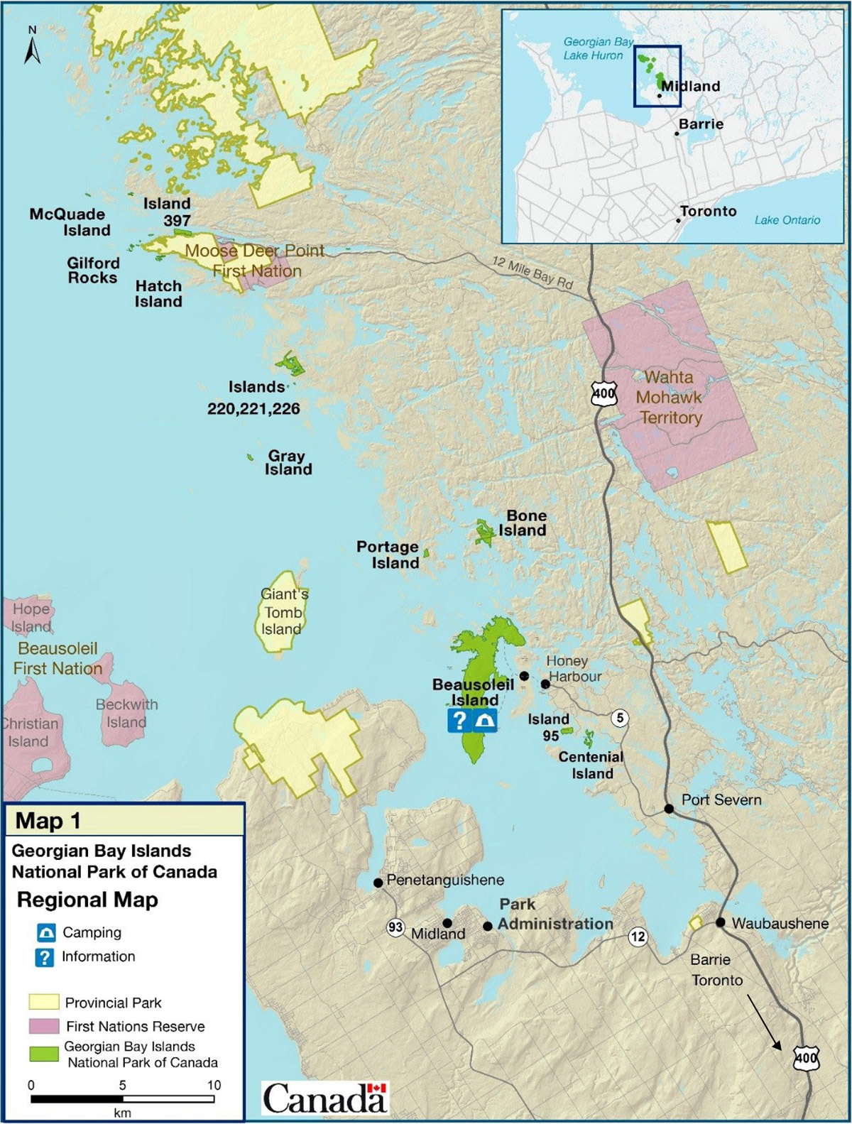
Map 1: Regional setting
3.0 Planning context
Georgian Bay Islands National Park is located approximately 160 km north of Toronto, Ontario and is within a half day’s drive for millions of Canadians. Consisting of 50 islands Footnote 1 and properties covering a total area of 14 km2, the park can only be accessed by boat. Visitors arrive via private watercraft, commercial operators, and the park-operated Day Tripper shuttle boat service. Beausoleil Island is both the largest and most culturally significant island within the park, and accounts for a majority of the land base.
Georgian Bay Islands National Park is located close to several First Nation and Métis communities, and is also within an area of traditional interest to others. These include Beausoleil First Nation, the Georgian Bay Métis Council, the Chippewas of Georgina Island First Nation, Chippewas of Rama First Nation, Huron-Wendat Nation, Potawatomie of Moose Deer Point First Nation, Shawanaga First Nation, Wahta Mohawks, and Wasauksing First Nation. Many of these communities are represented on the park’s Cultural Advisory Circle which has provided guidance and brought an Indigenous perspective to park management, cultural resources, languages, and programming for the past 20 years.
Visitors connect with the rich natural and cultural heritage of Georgian Bay Islands National Park through a wide range of activities including hiking, swimming, picnicking, canoeing, kayaking and docking opportunities, as well as overnight accommodation options including waterfront cabins, oTENTiks and traditional tent camping. The park also offers engaging programs such as interpretive presentations, Indigenous workshops, cultural activities and special events. Two YMCA camps have been operating in the park since 1919, integrating park learning opportunities and providing an exceptional opportunity to reach Canada’s youth.
Located outside the boundary of the park, the community of Honey Harbour has long served as the gateway to the park, and a key launch point for visitors to Beausoleil Island. Significant increases in the number of park visitors leaving from the Parks Canada operations base in Honey Harbour over the past decade has led to the area being at or beyond peak capacity during the summer months.
The park administration office is located in Midland, approximately 35 kilometers away from Honey Harbour, on the edge of the Wye River. This location also houses the field unit headquarters for four national parks and 15 national historic sites across Ontario.
This management plan replaces the 2010 management plan for Georgian Bay Islands National Park which provided direction for improving visitor facilities and services, protecting the iconic landscape and building partner support. Since 2010, the park has:
- Improved overall ecological integrity through restoration programs that target species-at-risk habitat improvements as well as the reduction of invasive species found in the park.
- Made significant improvements to the visitor experience by constructing a new visitor centre and comfortable overnight accommodations, enhancing interpretation, and improving capacity for day visitors through expanded Day Tripper (boat shuttle) service.
- Made investments of over 3.5 million dollars to improve park infrastructure such as docks, picnic shelters, trails, and water treatment systems through Federal Infrastructure Investment (FII) funds and other capital funding sources.
- Worked with Indigenous partners through the Cultural Advisory Circle to protect significant cultural resources and help visitors understand the significance of this cultural landscape.
The 2018 State of the Park Assessment identified four themes that need to be addressed during the implementation of the next management plan: conservation management within a broader fragmented ecosystem and adaptation to climate change; enabling access and sustainable visitor growth while enhancing a diverse and enjoyable visitor experience; strengthening formal Indigenous relations; and building brand awareness and community support.
Ecological Integrity
Conservation management actions at this small, island-based park have been beneficial to the park’s current state of ecological integrity. The challenge for this park relates to factors external to the park boundary. Increased population growth, development, and road networks across southern and central Ontario have reduced or greatly fragmented habitats and impacted the broader ecosystem. The park islands have increasingly become a refuge for a variety of species-at-risk (25). These pressures are not only impacting species-at-risk, they are also introducing and accelerating the pathways for non-native species with unknown long-term impacts to park biodiversity. Phragmites (a European shoreline reed) is a current concern since it has rapidly invaded the south side of Beausoleil Island and displaced native species, impacting the integrity of this coastal environment. Extreme high water, rapid fluctuations in lake levels, along with ice, wind and seiche events have eroded shoreline and caused significant damage to infrastructure and facilities. As a result, understanding both adaptation and resilience of ecosystems and infrastructure to climate change has become a top priority and will be integrated into conservation, visitor experience, and built asset objectives. This range of factors and effects are particularly impactful for an island-based park intrinsically shaped by water levels and their associated changes.
Visitor Experience and Access
The main visitor access and location of all services is Beausoleil Island. Facilities and services for visitors are available from late May until early October. Although park attendance is fairly stable, usually in the range of 41,000 to 44,000 visitors, the patterns of visitation have evolved over time. Demand for day visitation has increased, especially from residents of the Greater Toronto Area (the 2019 Visitor Information Program shows that visitors from Ontario make up the majority of visitors to the park). Roofed accommodation in the form of rustic cabins and oTENTiks are very popular with first-time visitors, while traditional tent camping has declined. Adapting the visitor experience program to meet the needs and expectations of current visitors is challenging, given the access limitations of an island park, available infrastructure and the park’s historic emphasis as a boating destination. The park operations base in Honey Harbour has become the launch point to facilitate access to the national park for those both staying in roofed accommodation and visiting for the day. However, the property and associated infrastructure is not conducive to support basic visitor services for the volume currently being experienced. Parks Canada’s ability to transport visitors to and from Beausoleil Island cannot keep up with increasing demand and visitors without reservations, who are turned away each day in peak season. New options are required to provide visitors with more opportunities to experience the park.
Boaters remain an important visitor group, accessing the park through many dock locations. The demand for docking facilities on most summer weekends is greater than what is available. Boaters do not access the park through a common entrance, and dated fee collection methods and limited connection with park staff remain challenges. Most dock areas require self-registration but park staff attend them for compliance and visitor services. As most docks have no time limit on the length of stay, those with seasonal mooring passes can enjoy long term stays, limiting dock accessibility for others.
Indigenous Relations
There have been several successful collaborations over recent years with Indigenous communities, in particular with the guidance and participation of the Cultural Advisory Circle. The Circle is made up of First Nations and Métis group members, as well as other partners such as the YMCA leadership and the Georgian Bay Biosphere Reserve. Contributions from the Cultural Advisory Circle continue to be an integral component for park management and strengthening this partnership will be critical as the park moves forward to incorporate the management of Beausoleil Island as a national historic site. While existing relationships between staff and community members are well established, stronger on-going dialogue and effective ways of working together directly with leadership of Indigenous communities is needed. A deeper collaboration and integration of Indigenous perspectives into park programming, resource management and decision-making is desired, as is a shared understanding of the park’s role in connecting Indigenous communities.
Regional Brand Awareness, Support and Partnering
The park has strong long-standing relationships with members of regional Indigenous groups, two YMCA camps and works with numerous local and regional partners. As a core protected area within the Georgian Bay Biosphere Reserve, the park is part of a network that works toward common goals and interests. Increased participation with and support from these partners will be imperative in setting future direction for the park.
Many regional residents, partners and stakeholders are familiar with Beausoleil Island, but may not know it is part of Georgian Bay Islands National Park or its role as a Parks Canada administered heritage place. The park has several successful existing partnerships for tourism, marketing and conservation, yet there remains a lack of recognition and awareness of the park. A shift is needed to nurture a sense of pride in, and support for the park, and to create opportunities for meaningful engagement.
4.0 Vision
Shaped by wind and water, our vision is to be a peaceful gathering place deeply rooted in memory and in connection to nature.
Georgian Bay Islands National Park and Beausoleil Island National Historic Site, along with their trusted partners, are proud ambassadors of the world’s largest freshwater archipelago along southeastern Georgian Bay. Together, they lead the way in conservation, experiential learning, and engagement with Indigenous peoples, leaving visitors transformed and inspired. The islands are a refuge for biological diversity and a catalyst for regional conservation.
In 15 years Georgian Bay Islands National Park will be renowned:
- For having an exceptional ecosystem with incredible biodiversity;
- For leading edge, forward-thinking conservation management that includes scientific research, Indigenous knowledge, collaboration with partners, and addresses the effects of climate change and landscape fragmentation;
- As a place where Indigenous heritage and cultures are respectfully woven throughout conservation management and visitor programs, and Indigenous partners contribute to decision-making related to heritage place management;
- As a welcoming place to gather for spiritual and physical connection with the natural world;
- For being a place of memory- both historically and as a place where memories are created;
- As a place where Indigenous people recognise themselves, their stories and their heritage;
- For building and maintaining strong relationships, and being an important regional leader for conservation and tourism partnerships;
- As an invigorating journey starting from the moment visitors arrive and are transported over the sparkling waters of Georgian Bay. Visitors discover an incredible wilderness where they understand and are inspired by the inseparable link between nature and culture.
5.0 Key strategies
Four strategies frame the management direction for Georgian Bay Islands National Park for the next ten years. The strategies and corresponding objectives and targets lay out a roadmap for achieving the vision for the park through an integrated approach to park management. Targets will be achieved by the specified dates or earlier, depending on opportunities, annual priorities and operational capacity. Unless otherwise specified, all targets are meant to be achieved within the ten-year period of the plan.
Key Strategy 1:
Managing conservation and climate change adaptation within a broader fragmented ecosystem
Understanding the ecological pathway of Georgian Bay Islands National Park is challenging as the lands surrounding the park have been developed and have isolated the park from its broader landscape. With that, ecological resiliency and adaptation will be incorporated into the future of conservation management. This will become more urgent as climate change impacts will have greater influence on the very shape and shoreline of the island, its biodiversity, visitor services and the cultural landscape. The park cannot achieve success in isolation. The ecological aspirations for the region, crucial to the structure and function of the park, are inextricably linked to integration and collaboration across multiple jurisdictions and with various partners. Given the high degree of influence of external factors on the park ecosystem, there will be a need to consider the future condition of the park in order to manage towards its optimal viability and to prevent ecological collapse. Effective demonstration of stewardship techniques that engage visitors and area residents will be key to success. Habitat protection, resilience and enhancement, particularly for species-at-risk, will be paramount in management decisions.
Objective 1.1:
The ecosystem is maintained within Georgian Bay Islands National Park
Targets:
- In the next State of the Park Assessment, the overall ecological integrity indicators show a stable or improving trend:
- The forest and coastal/marine indicators continue to show a good condition rating.
- The wetlands indicator shows a stable or improving trend.
- By 2024, ecological stressors, including invasive species, are addressed through mitigation and adaptation techniques to facilitate greater ecological resiliency.
- By 2028, through strengthened local relationships, Indigenous knowledge is respectfully integrated into the decision-making process.
Objective 1.2:
Conservation goals are achieved through integration with regional conservation groups.
Targets:
- By 2024, effective conservation efforts will consider the broader landscape and work with partners to harmonize strategies that will achieve results.
- By 2025, conservation efforts are supported through new and existing partnerships (with a range of groups) that will respectfully weave Indigenous knowledge into projects.
Objective 1.3:
The impacts of climate change are better understood and mitigated.
Targets:
- By 2024, maintenance and capital strategies and plans targeted at increasing the climate resiliency of shoreline infrastructure have been developed to ensure long term sustainability.
- By 2028, ecological restoration considers optimum viability for future ecosystem stability and transition during times of instability.
Objective 1.4:
Species-at-risk are protected.
Targets:
- On an ongoing basis, the Multi-species Action Plan is implemented and continues to be an influential yet dynamic reference to support the conservation, recovery and long term viability of the species-at-risk.
- By 2026, the park is a leader in species-at-risk knowledge and sharing that knowledge throughout the broader community.
- By 2029, a land protection strategy across the broader ecosystem is developed that identifies potential partners as well as key properties that would support species-at-risk populations.
Objective 1.5:
Cultural resources are protected.
Targets:
- By 2026, the park will work with Indigenous knowledge holders to foster a deeper understanding and appreciation of the cultural landscape of Beausoleil Islands NHS
- By 2026, Beausoleil Island will be a place of ceremony that celebrates contemporary cultural values and fosters re-connections for Indigenous peoples with the cultural landscape.
- By 2027, a Commemorative Integrity Statement, building upon the approved historical narrative is finalized.
Key Strategy 2:
Enabling access and enhancing a diverse and enjoyable visitor experience
Given the impact of fluctuating water levels in the arrival and departure areas on Beausoleil Island, a holistic plan for the approximately 1 km stretch of shoreline will be key for this strategy. Rehabilitating, repairing or designing new climate resilient/adaptable shoreline infrastructure will facilitate arrival and access to the ‘’gathering place’’ and instill a sense of wonder from the moment of arrival. Partnerships with Indigenous groups, the private sector, and others, will enable access for all to a Beausoleil Island experience and help visitors to connect with the amazing natural and cultural heritage of the park. Creating and fostering new partnerships will help develop innovative experiential programming. The park will encourage a more family-friendly environment and ensure visitors are charmed and enlightened when exploring new outdoor recreation and innovative learning opportunities. Designing for various user group needs will help ensure a better experience and desired depth of connection to place. The park will use visitor management and green strategies to ensure protection of natural and cultural resources while providing exceptional visitor experiences. Improved management and processes around water lots, dock use and mooring policies will also help improve visitor experience and access throughout the park. Sacred and traditional use, day use, camping, boating and use associated with accessibility considerations will be key segments for design consideration
Objective 2.1:
A new sense of welcome is conveyed at Georgian Bay Islands National Park as a result of arrival areas being repaired, rehabilitated or purpose built with climate resilient design adaptations that meet the distinct needs of each user group.
Targets:
- By 2027, a vision for the shoreline will be designed in consultation with Indigenous and other strategic partners that will address a range of requirements for third party operators, staff, special events, and mobility access.
- By 2028, space is created on Beausoleil Island to welcome all visitors and create a sense of arrival that meets or exceeds expectations through the implementation of visitor use management tools and intelligent design solutions.
Objective 2.2:
Access to the park and its experiences is improved, facilitating new offers and meaningful experiences for an increasingly diverse range of visitors.
Targets:
- By 2024, a review of park infrastructure and programming is completed to identify potential opportunities for creating barrier-free and inclusive facilities and experiences.
- By 2025, new partnerships (e.g. third parties) are developed and in place to create and improve the range of opportunities to access the park for all visitors (e.g. day-use, overnight).
- By 2026, an analysis of services offered to boaters and other visitors, including segment demand, seasonal passes, mooring permits, payment and reservation options is completed and processes are modernized and improved as required.
- By 2027, a strategy is developed for greening of park operations and visitor experiences, incorporating new products and processes where economically and operationally feasible.
Objective: 2.3:
Working with partners, meaningful experiences are offered at Georgian Bay Islands National Park and connections are forged with the invaluable treasures of this island park.
Targets:
- By 2028, a visitor experience strategy is completed, identifying opportunities to engage partners in enhancing the visitor offer.
- By 2028, Indigenous partners lead in sharing the compelling cultural significance of Georgian Bay Islands National Park and Beausoleil Island National Historic Site.
- In the next State of the Park Assessment:
- Visitors rate the satisfaction of their overall visit at a minimum 90%.
- At least 90% of visitors enjoy their visit.
- At least 85% of visitors consider the park meaningful to them.
- The number of visitors who consider they learned about the natural and cultural heritage shows an increasing trend.
Key strategy 3:
Strengthening formal Indigenous Relations — Sharing the heritage and culture
Sharing the stories and cultural heritage of Indigenous peoples in this pristine archipelago setting is essential to Georgian Bay Islands National Park. The park experience will be transformative for visitors who will leave with a greater understanding and appreciation of Indigenous cultures and heritage. To that end, the park will continue to rely on collaborative work with Indigenous partners such as the Cultural Advisory Circle and create new strong relationships with Indigenous communities and elected officials. Building on the foundation of respect, mutual trust, traditions and communication while identifying common goals, the park will foster on-going connection between Indigenous peoples and the lands and waters that make up the park.
Objective 3.1.
Indigenous knowledge is woven into park operations and management.
Targets:
- The Cultural Advisory Circle continues to meet regularly to:
- Provide guidance and advice on cultural heritage relating to Georgian Bay Islands National Park and Beausoleil Island National Historic Site;
- Enhance cultural heritage understanding among park staff and visitors.
- By 2024, formal working relationships with Indigenous communities are established based on their interest and priorities.
- By 2026, a regional approach to collaborating on park matters is in place (i.e. a forum or agreement on how to work together for consultation, youth opportunities and to collaborate on decision-making and park management).
Objective 3.2:
Indigenous peoples’ connection to traditionally used lands within the national park is strengthened.
Target:
- By 2023, opportunities are developed collaboratively with Indigenous partners to ensure community members have opportunities to connect with the park and to identify a sacred place for ceremony.
Objective 3.3:
The park works with Indigenous communities in the area on increasing employment opportunities for Indigenous peoples (e.g. Internships).
Targets:
- By 2024, economic and employment opportunities for Indigenous partners are identified.
- By 2026, at least one Indigenous tourism program is offered on-site by Indigenous partners and Parks Canada.
Key Strategy 4:
Building national park awareness and community support — The invaluable treasures of the park are known
Parks Canada will improve its regional branding and showcase its role in protecting and influencing stewardship within the greater ecosystem. Many will be inspired to visit this unique archipelago destination and create their own meaningful connections by enjoying the views, the water, family moments, exploring the invaluable natural and cultural treasures, and volunteering through a range of stewardship endeavours. Stronger partnerships and involvement will help the park enrich its programming.
Objective 4.1:
Canadians are aware of Georgian Bay Islands National Park and its associated experiences.
Targets:
- The park’s social media followers increase by 10% annually.
- By 2023, local and national media outlets begin to cover the park as a source of regular stories and feature angles (conservation, cultural, Indigenous, history).
- By 2026, social media and/or new media opportunities connect with regional residents and other key targeted audiences to curate online communities interested in park activities and opportunities.
- By 2026, mutually beneficial cross-promotion and packaged experiences are in place with partners.
Objective 4.2:
Community support and engagement is increased as a result of stewardship projects with partners, stakeholders and visitors.
Targets:
- By 2023, a plan adapted to annual priorities and engagement targets outlines local outreach and regional events, including participation in indigenous ceremony, conservation conferences, parades and festivals.
- By 2027, strategic partnerships are planned and/or expanded to support regional conservation efforts and visitor experience programs
- By 2026, the number of volunteer and/or volunteer numbers per program show increasing trends.
6.0 Management areas
In support of the four key strategies, this section presents detailed objectives for specific locations within Georgian Bay Islands National Park, including Beausoleil Island National Historic site, Outer/Northern Islands and Cedar Spring.
Beausoleil Island National Historic Site of Canada
Known to the Anishinaabeg as Baamidoonegog, “rocky place floating about the mouth of a river”, Beausoleil Island is the largest island in Georgian Bay Islands National Park and was officially designated a national historic site in 2011. It was designated because:
- it is representative of the cultural landscape of the Anishinaabeg of the southern Georgian Bay region, demonstrating the land's role as a place of memory, illustrating their people's relationship with the land, and recalling the Anishinaabe presence in Southern Ontario and their subsequent displacement;
- it is the setting for traditional narratives that record the island's creation and meaning. Many of the traditions associated with the island relate to women, including their use of Beausoleil for gathering berries and other plants, and for traditional ceremonies such as girlhood to womanhood transformation rituals; and,
- it has been witness to a long history of settlement. The evolving landscape of the island includes evidence of ancient camps and of its brief period as a reserve in the mid-19th century when the Anishinaabeg struggled to find a new way to live that was compatible with their traditions and with the rapidly growing Euro-Canadian settlement surrounding them.
This designation is an opportunity to protect and highlight the island’s historic value and character-defining elements. Strengthening Indigenous relationships will be critical as the park moves forward to incorporate the management of Beausoleil Island as a national historic site.
Objective:
Beausoleil Island National Historic Site and its significance is well known as a national historic site, becoming synonymous with Georgian Bay Islands National Park
Targets:
- Visitors to the park and local residents are aware of the national historic site and its cultural significance.
- By 2024, in conjunction with shoreline rehabilitation, a cultural and historical narrative is developed with language and imagery and design treatment that resonates deeply with Indigenous partners and highlights the significance of Beausoleil Island National Historic Site.
Objective:
The park strives for Indigenous collaboration in regards to cultural components.
Targets:
- The park works in collaboration with Indigenous communities with respect to cultural resource areas, archeological work, interpretation and direction setting.
- Cultural resources areas are updated regularly and considered in decision-making.
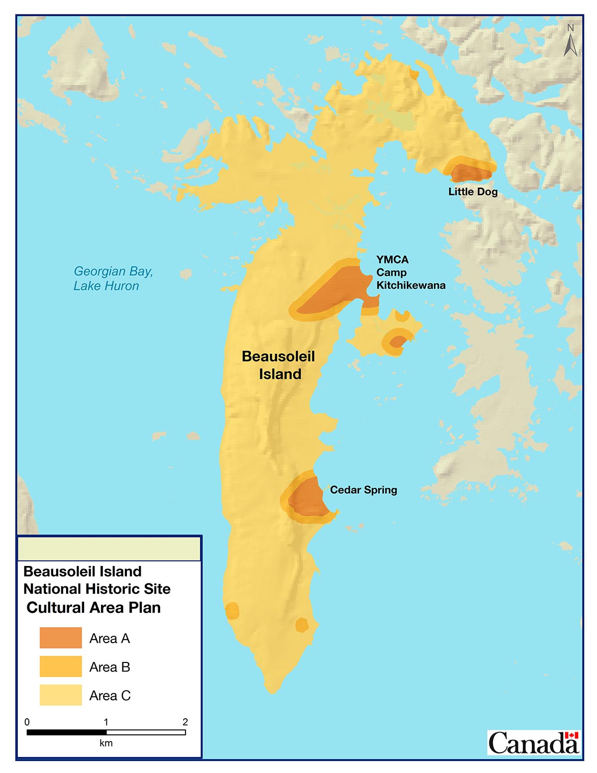
Area considerations for cultural values as a national historic site
Beausoleil Island has been designated as a national historic site not only for its tangible points of human history, but also in recognition as a cultural landscape. A cultural landscape is an area that reflects on the intangible qualities that characterize a “sense of place” and integrates both the natural values and human values. Currently, the concept of a cultural landscape is not reflected in the management plan.
The intent here is to identify a spectrum of areas that spatially characterize cultural values, from the tangible to the intangible, into the planning process. This will assist park management in ensuring spatially explicit cultural values are considered in the decision making process, similar to ecological values within the national park.
The implementation is not intended to be restricting activities from certain areas (as done in a national park), but prescriptive on how the activity can proceed with the heritage values of the national historic site maintained. In this approach, there are three cultural resource areas that should be considered:
Area A: Culturally significant areas where historic use existed. These areas are more sensitive to development and disturbance that require mitigation. Much of these areas have been surveyed. These are point locations, or well defined areas.
Area B: A buffer of the known culturally significant areas or place whereby people exercised their influence on the landscape. They may have less tangible indicators of human use. This may include cultivated or managed landscape signs such as disturbance to support livelihoods (fire, agriculture, berries, etc.).
Area C: Reflects on the cultural landscape as a “sense of place’’. This type of area reflects the environment from which people defined “home’’, a connection to the land that may possess intangible heritage value.
Map 2: Cultural area plan Footnote 2
YMCA camps
Camp Kitchikewana and Camp Queen Elizabeth introduce over 4,500 young campers per year to Georgian Bay Islands National Park. The two YMCA Camps (Simcoe-Muskoka and Western Ontario chapters) are critical long-term partners at the park, with Camp Kitchikewana pre-dating the establishment of the national park and holding its 100th anniversary in 2019. The close working relationship between the park and camps provides unparalleled opportunities to deliver key Parks Canada messages to receptive target youth audiences. The YMCA camps provide key opportunities to reach important multiplier audiences such as camp staff and educators. Opportunities also exist to leverage the use of YMCA facilities by park teams and Indigenous partners. Both camps are located within species-at-risk habitat and areas containing significant Indigenous cultural resources, providing excellent linkages to reach campers and instill a strong connection to place and sense of relevance and reverence. The YMCA camps will continue to be managed to respect the cultural and natural setting of the park.
Objective:
Youth are provided opportunities to form life-long memories while learning to appreciate the natural and cultural significance of Georgian Bay Islands National Park at the YMCA Camps (Camp Kitchikewana and Camp Queen Elizabeth).
Targets:
- By 2024, learning and training programs are expanded, including interpretive programs to campers, volunteer opportunities for Leaders-in-Training, park awareness and species-at-risk training for camp staff, and professional development opportunities for educators.
Outer/Northern Islands
Beausoleil Island, which is over 70% of the park’s total area, serves as the location for visitor services and facilities in the park. However, it is the balance of the park area that forms the most iconic images of Georgian Bay. Tightly woven fabrics of juniper covering the crevices of ancient granite outcroppings and gnarled pine trees bending to the direction of the west wind have inspired those who have come this way before and continue to this very day. This is a place of refuge, a place of solitude. This is where colonies of nesting gulls and herons try to escape the predators of the mainland, only to be met by the Eastern Foxsnake. These islands are vital to the ecological integrity of this archipelago and contribute to understanding change across the broader landscape. They will continue to be managed with minimal human interference.
Objective:
Visitor services continue to be supported on Beausoleil Island. The remaining islands contribute to the conservation vision and are part of the inspirational fabric of the 30,000 islands.
Target:
- By 2030, where appropriate, visitation is supported by non-consumptive opportunities such as virtual reality and effective outreach initiatives, and the outer/northern islands continue to be a source of inspiration for all Canadians.
Cedar Spring
Cedar Spring is the main visitor hub and access point on Beausoleil Island, however rapid water level fluctuations and high lake levels have severally impacted shorelines infrastructures in recent years. As such, future visitor offers will be affected by the scale and timing of funding available to rehabilitate, repair and make climate resilient adaptations. The integration of plans, designs and strategic environmental assessments will be incorporated over the next 5 years to outline the needs and potential of this approximately 1 km of shoreline and surrounding visitor nodes. Access by third party operators to provide visitor services will also be focussed here. Currently, island camping is offered in an area surrounded by lush hardwood forest along the Georgian Bay shoreline. The visitor information centre is located at Cedar Spring, along with roofed accommodation options, and a 45-site campground that offers the highest level of facilities at the park including showers, washrooms, and potable water. Day-use facilities, interpretive media and programming, park sales and rentals, and access to hiking trails are all available in Cedar Spring, as are areas that focus on ecological initiatives such as pollinator gardens and species-at-risk habitat.
Objective:
Cedar Spring serves as an efficient central hub for visitor orientation and experience, facilitating opportunities for growth in visitation and experience.
Targets:
- By 2027, the integration of plans that include visitor experience, accessibility, user group management, visitor services and infrastructure is completed in light of climate change adaptations respecting available funding options.
- By 2028, a sense of welcome and arrival is created for visitors at Cedar Spring, focussing on the role and history of Indigenous people on the Island, and the nature of entering protected habitat.
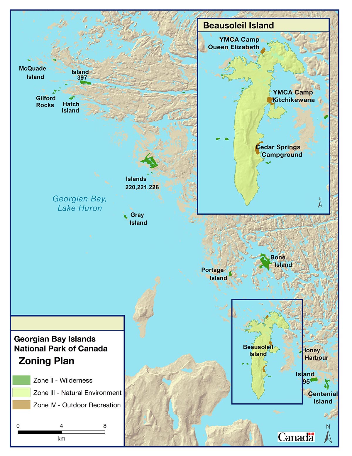
7.0 Zoning
Parks Canada’s national park zoning system is an integrated approach to the classification of land and water areas in a national park and designates where particular activities can occur on land or water based on the ability to support those uses. Considering the small geographic footprint of Georgian Bay Islands National Park, the zoning includes three categories:
- Zone II – Wilderness Area
- Zone III – Natural Environment
- Zone IV - Outdoor Recreation
Zone II: Wilderness Area
Zone II wilderness areas are meant to protect representative natural landscapes where visitors can experience nature with minimal human intrusion or facilities. The visitor experience in these areas is focused on self-propelled activities. No motorized access or circulation is permitted.
Zone II wilderness areas represent 17% of all park lands. These Zone II areas encompass all lands and islands except Beausoleil Island. These islands have significant ecological and species-at-risk habitats and cannot support visitor infrastructure.
Zone III: Natural Environment
Zone III areas are managed as natural environments that are capable of supporting a range of visitor experiences. These areas enable visitors to enjoy and learn about the parks natural and cultural features through outdoor recreational and educational activities requiring minimal facilities and services.
Zone III includes the majority of Beausoleil Island. These areas encompass 82% of all park lands.
Zone IV: Outdoor Recreation
Zone IV designation is applied to limited areas that are capable of supporting more intensive visitor use and major facilities.
The zone IV areas include: the two YMCA camps and Cedar Spring campground. These areas encompass 1% of all park lands.
Non-conforming use
Over snow vehicle use is a popular winter pastime throughout the region. The vast majority of the use occurs on Georgian Bay, however, people also use trails on Beausoleil Island. In order to prevent the impacts of random access the park will direct use to the Huron/Rockview/Portage Trail. The activity is considered an environmental mitigation, and not supported as a visitor experience.
Map 3: Zoning
8.0 Summary of the strategic environmental assessment
All national park management plans are assessed through a strategic environmental assessment to understand the potential for cumulative effects. This understanding contributes to evidence-based decision-making that supports ecological integrity being maintained or restored over the life of the plan. The strategic environmental assessment for the Management Plan for Georgian Bay Islands National Park considered the potential impacts of climate change, local and regional activities around the park, expected changes to the volume and character of visitation and proposals within the management plan. The strategic environmental assessment assessed the potential impacts on different aspects of the ecosystem, including forest habitat, coastal habitat, herpetofauna, species-at-risk, colonial water birds and cultural resources.
Georgian Bay Islands National Park is part of the world’s largest freshwater archipelago, and at 14 km2, is Canada’s smallest national park. The park is a renowned refuge for herpetiles in the region, and is a core protected area within the United Nations Educational, Scientific and Cultural Organisation (UNESCO) Georgian Bay Biosphere Reserve. As an island-based park, Georgian Bay Islands National Park remains sensitive to external factors, such as climate change and water level fluctuations, and regional habitat changes. The ecological monitoring program has been designed to focus on these sensitivities. The management plan focuses on the park’s contribution to maintaining the high biodiversity of the region and the importance of working with local partners in the region and deepening relationships with Indigenous groups, in order to manage the cumulative effects on the identified valued components. The management plan identifies objectives to understand environmental change in the park and adapt management practices to the evolving environment. Adaptation and resilience to climate change will drive the future design of infrastructure within the park, as well as conservation activities. Beausoleil Island National Historic Site was established since the last Management Plan. Its designation as a national historic site and identification of cultural areas that guide management activities will help to mitigate the potential cumulative impacts of park management activities on cultural resources. No further mitigation measures were identified through the SEA in addition to the management plan, existing management action and legislative requirements.
Indigenous partners, stakeholders and the public will be consulted on the draft management plan and summary of the draft strategic environmental assessment. Feedback will be considered and incorporated into the strategic environmental assessment and management plan as appropriate.
The Strategic Environmental Assessment was conducted in accordance with the Cabinet Directive on the Environmental Assessment of Policy, Plan and Program Proposals (2010) and facilitated an evaluation of how the management plan contributed to the Federal Sustainable Development Strategy. Individual projects undertaken to implement management plan objectives at the site will be evaluated to determine if an impact assessment is required under the Impact Assessment Act, or successor legislation. The Management Plan supports the Federal Sustainable Development Strategy goals of Greening Government, Healthy Coasts and Oceans, Sustainably Managed Lands and Forests, Healthy Wildlife Populations, and Connecting Canadians with Nature.
Many positive environmental effects are expected from the implementation of the management plan, including the identification of strategies to increase the park’s resilience and ability to adapt to climate change, the continued protection of sensitive species and their habitat, reduction in persecution of herpetofauna through public outreach and education efforts and management of invasive species. There are no important negative environmental effects anticipated from implementation of the Georgian Bay Islands National Park of Canada Management Plan.
Related links
- Date modified :