
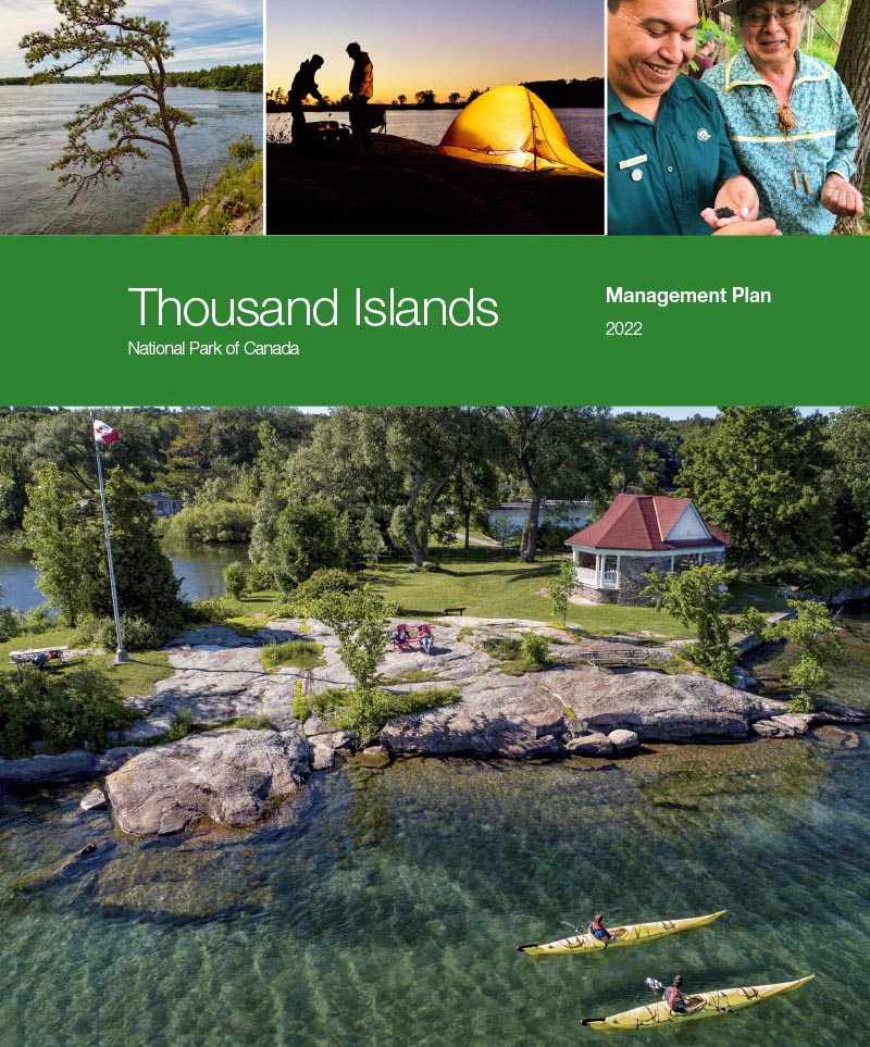
Thousand Islands National Park of Canada Management Plan, 2022
Thousand Islands National Park
Title: Thousand Islands National Park of Canada Management Plan, 2022
Organization: Parks Canada Agency
Note to readers
The health and safety of visitors, employees and all Canadians are of the utmost importance. Parks Canada is following the advice
and guidance of public health experts to limit the spread of COVID-19 while allowing Canadians to experience Canada’s natural
and cultural heritage.
Parks Canada acknowledges that the COVID-19 pandemic may have unforeseeable impacts on the Thousand Islands National
Park of Canada Management Plan. Parks Canada will inform Indigenous partners, stakeholders and the public of any such impacts
through its annual implementation update on the implementation of this plan.
Table of contents
Maps
Foreword from Minister

Minister of Environment and Climate Change and Minister responsible for Parks Canada
From coast to coast to coast, national historic sites, national parks and national marine conservation areas are a source of shared pride for Canadians. They reflect Canada’s natural and cultural heritage and tell stories of who we are, including the historic and contemporary contributions of Indigenous peoples.
These cherished places are a priority for the Government of Canada. We are committed to protecting natural and cultural heritage, expanding the system of protected places, and contributing to the recovery of species at risk.
At the same time, we continue to offer new and innovative visitor and outreach programs and activities to ensure that more Canadians can experience these iconic destinations and learn about history, culture and the environment.
In collaboration with Indigenous communities and key partners, Parks Canada conserves and protects national historic sites and national parks; enables people to discover and connect with history and nature; and helps sustain the economic value of these places for local and regional communities.
This new management plan for Thousand Islands National Park of Canada supports this vision.
Management plans are developed by a dedicated team at Parks Canada through extensive consultation and input from Indigenous partners, other partners and stakeholders, local communities, as well as visitors past and present. I would like to thank everyone who contributed to this plan for their commitment and spirit of cooperation.
As the Minister responsible for Parks Canada, I applaud this collaborative effort and I am pleased to approve the Thousand Islands National Park of Canada Management Plan.
Foreword by the Mohawk Council of Akwesasne
Reflecting on the past, present, and future from two worlds
We invite you into a moment of reflection to think about the past, present, and future of Thousand Islands National Park. We acknowledge the importance of community, place, and creation. It is through an interconnected relational network that we find ourselves thinking and planning how to be the best caretakers of these lands. More than ever, caring for national parks is important to protecting the world’s biodiversity, addressing mental health, embodying Haudenosaunee values, and responding to climate change.
This management plan acknowledges the importance of maintaining and improving relationships between Indigenous people and the lands and waters of Thousand Islands National Park that carry teachings to help guide us forward. The Two-Row Wampum was an agreement established between the Haudenosaunee and Dutch, two mutually consenting parties, to respect the autonomy of each other in perpetuity. This agreement and teaching helps carry our minds forward, in a good way, as we engage in different relationships or negotiate different paradigms from around the world. Renewing the relationship between the park and Akwesasne, or polishing the Kaswentha (wampum), is an important means of ensuring this relationship remains healthy and strong. As part of this effort, the park and Akwesasne will carry out another Smokey Fire ceremony, last done in 2007, to rekindle the love and life that initially ignited the partnership that has produced so many successes. Our relationship will continue to draw upon the foundational principles of the Kaienerakowa (Great Law), which are Sken:nen (Peace), Kasastenserah (Power), and Kanikonriio (Good Mind). We must bring ourselves to acknowledge the relationships that exist beyond people connecting us to all of creation. The Haudenosaunee do this through the Ohenten Kariwahtkwen (Thanksgiving Address). We bring our minds together to acknowledge that all of creation has roles and responsibilities to each other, and we must keep these relationships in mind when we make important decisions. At Thousand Islands National Park, all people have the opportunity to reconnect and develop our relationship with creation. Akwesasne and Thousand Islands National Park will continue to work together to take small conservation actions that have resounding impacts.
This management plan aims to improve access and human connection to Thousand Islands National Park. The COVID-19 extended reality has left people exhausted and anxious about the future. Conversations about mental health have been brought to the forefront and people are taking the time to find mechanisms for self-care. In particular, the grief felt individually and collectively by the world has left us with a heaviness on our minds, emotions, spirits, and bodies. The Haudenosaunee speak to the experience of grief as though our fire has been scattered and the smoke has filled our eyes, ears, and mouth so we are unable to see, hear, or speak clearly. We use our medicines which are found on the land to help us get through these moments and to clean the smoke from our eyes, ears, and mouth. The land not only offers medicines in the material form; the land offers a space for connection, renewal, acknowledgment, and peace.
This management plan addresses the importance of responding to the effects of climate change. COVID-19 has taught us that there is hope for addressing climate change and that we can use this as a catalyst to create adaptations that are good for us, future generations, and for the lands that sustain us. There is evidence globally that the pandemic has led to positive environmental impacts related to decreased air pollution, lower greenhouse gas emissions, and improved water quality. Recent times have demonstrated that we have the power to come together to make intentional changes by disrupting systems that were previously thought to be unchangeable. We need to remind ourselves to prioritize life over profit and deconstruct systems that do not see this value. Additionally, we must bring our minds together to understand that we live in a world of systemic oppression, and climate change action must be accompanied by social change. In the wise words of queer artist, Demian DinéYazhi', who gracefully articulated, “Indigenous Sovereignty and Land Back movements cannot be realized without amplifying, empowering, and continually fostering solidarity with Black Liberation, Migrant rights, Disability Justice, Trans rights, and Asian and Pacific Islander empowerment” (Demian DinéYazhi', 2021). The future we seek must create space for all to find a place and a connection with each other and all of creation.
We must work together to strengthen our relationships. We maintain peace amongst each other by moving forward with intentions grounded in a good mind. This management plan sets out key intentions for the future of Thousand Islands National Park. Indigenous people comprise less than 5% of the world’s population and protect 80% of global biodiversity (The World Bank, 2008). Herein lies the importance of collaboration that traverses cultural boundaries because complex problems require complex solutions that only diverse minds can bring to life. Furthermore, we must protect and engage with these landscapes as kin, because they are here to care for us as we are here to care for them – our future depends on it.
Recommendations
Recommended by:
Ron Hallman
President & Chief Executive Officer
Parks Canada
Andrew Campbell
Senior Vice-President, Operations Directorate
Parks Canada
Katherine Patterson
Superintendent, Eastern and Central Ontario Field Unit
Parks Canada
Executive summary
In the heart of the Thousand Islands, on traditional Haudenosaunee and Anishinaabe (Algonquin of Ontario) lands, Thousand Islands National Park consists of several mainland properties, 26 islands, and 89 islets and shoals. The properties extend across a 120-kilometre stretch along the St. Lawrence River and Lake Ontario from Brockville to Prince Edward County. The park was initially established in 1904 as St. Lawrence Islands National Park, and officially renamed in 2013.
Thousand Islands National Park is a core protected area of the Frontenac Arch Biosphere Reserve. The park is located at the crossroads of the St. Lawrence River and the Frontenac Arch, and is in the transition zone between Eastern Deciduous and Boreal Forests. Because of this, the region is one of the most biodiverse in Canada. The park has more regularly occurring reptile and amphibian species than any other Canadian national park. The park also represents a rich cultural landscape of human activity. Many generations have connected to this place including pre-contact and contemporary Indigenous groups, military and trade route travellers, early island settlers and farmers.
The park offers facilities and services to visitors at three of its mainland properties: Landons Bay, Mallorytown Landing and Jones Creek. These hubs, featuring a variety of trails, a former church campground and recreation facility, oTENTik accommodations, a visitor centre and an administration office, are situated on the Thousand Islands Parkway between Brockville and Gananoque. The vehicular and cycling parkway runs along the river, parallel to the nearby Highway 401, approximately halfway between Toronto and Montréal. Visitors, with either their own or third-party boat and kayak access, can enjoy docks, trails and diverse camping and accommodation offers at 20 island locations.
This management plan replaces the 2010 management plan for St. Lawrence Islands National Park, now called Thousand Islands National Park. Since 2010, the park has improved overall ecological integrity by engaging with stakeholders, local landowners, volunteers and Indigenous partners; developed a multi-species action plan; improved marine structures; established strong foundational relationships with several partners; and undertaken initiatives to increase access to islands for paddlers and campers.
Engagement and consultation with partners and stakeholders as well as the general public in the preparation of this management plan yielded key thematic areas for guiding management activities at Thousand Islands National Park for the next ten years.
The four key strategies for the ten-year management plan are:
Key strategy 1
Working together to achieve conservation goals in a fragmented and developed landscape
This strategy focuses on positive conservation outcomes for the park and for the region through collaborative relationships with a range of partners.
Key strategy 2
Re-imagining the Thousand Islands National Park experience
This strategy aims to develop new experiences that immerse both island and mainland visitors in the unique ecology of the area and the rich cultures of Indigenous peoples.
Key strategy 3
Building resilience and sustainability of assets
This strategy focuses on modernizing the asset base from its eclectic mix of antiquated facilities toward unified design aesthetics and elements that support the park’s conservation and visitor experience objectives.
Key strategy 4
Recognizing the value of Thousand Islands National Park
This strategy aims to improve Parks Canada’s regional brand awareness and highlight its role in managing Thousand Islands National Park.
Introduction
Parks Canada administers one of the finest and most extensive systems of protected natural and historic places in the world. The Agency’s mandate is to protect and present these places for the benefit and enjoyment of current and future generations. Future-oriented, strategic management of each national historic site, national park, national marine conservation area, and heritage canal administered by Parks Canada supports the Agency’s vision:
Canada’s treasured natural and historic places will be a living legacy, connecting hearts and minds to a stronger, deeper understanding of the very essence of Canada.
The Canada National Parks Act and the Parks Canada Agency Act require Parks Canada to prepare a management plan for each national park. The Thousand Islands National Park of Canada Management Plan, once approved by the Minister responsible for Parks Canada and tabled in Parliament, ensures Parks Canada’s accountability to Canadians, outlining how park management will achieve measurable results in support of the Agency’s mandate.
Indigenous peoples are important partners in the stewardship of heritage places, with connections to the lands and waters since time immemorial. The Mohawks of Akwesasne, stakeholders, partners and the Canadian public were involved in the preparation of the management plan, helping to shape the future direction of the national park. The plan sets clear, strategic direction for the management and operation of Thousand Islands National Park by articulating a vision, key strategies and objectives. Parks Canada will report annually on progress toward achieving the plan objectives and will review the plan every ten years or sooner if required.
This plan is not an end in and of itself. Parks Canada will maintain an open dialogue on the implementation of the management plan, to ensure that it remains relevant and meaningful. The plan will serve as the focus for ongoing engagement and, where appropriate, consultation, on the management of Thousand Islands National Park in years to come.
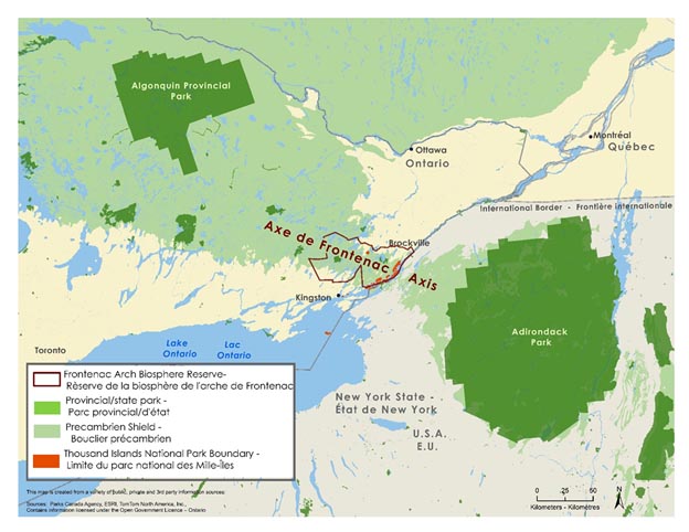
Map 1: Regional setting — Text version
This is a map showing the regional setting for Thousand Islands National Park. The geographical extent includes south-eastern Ontario, southern Quebec, and northern New York state including Lake Ontario. The cities of Ottawa, Toronto, Kingston, and Brockville, Ontario; and Montreal, Quebec. There is a legend at the bottom left corner of the map and a 0 to 60 km scale.
The Frontenac Arch Biosphere Reserve is outlined in burgundy extending west from Brockville, ON, through the Frontenac Axis north of Kingston ON. The Precambrian Shield appears in light green and covers the lands at the northern section of Ontario connecting through the Frontenac Axis into New York State. Algonquin Provincial Park and Adirondack State Park are shown in dark green as the largest parks in the Precambrian Shield. Thousand Islands National Park boundaries are shown in red at the south eastern edge of the Frontenac Arch Biosphere Reserve.
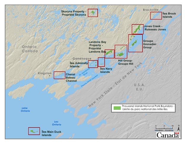
Map 2: Thousand Islands National Park — Text version
This is a map showing the properties managed by Thousand Islands National Park. The geographic extent includes eastern Lake Ontario with the St. Lawrence River between Ontario, Canada and New York State, USA. There is a scale at the bottom right showing 0-10 km with a legend above the scale depicting the boundary of Thousand Islands National Park, including: Main Duck Islands; Bateau Channel; Admiralty Islands; Navy Islands; Landons Bay Property; Hill Group; Grenadier Group; Jones Creek; Brock Islands; and the Skoryna Property.
Significance of Thousand Islands National Park
Initially established in 1904 as St. Lawrence Islands National Park, and officially renamed in 2013, Thousand Islands National Park was the first Canadian national park east of the Rocky Mountains.
Thousand Islands National Park is a core protected area of the UNESCO Frontenac Arch Biosphere Reserve and representative of the St. Lawrence Lowlands and the Canadian Shield. The park is located at the crossroads of the St. Lawrence River and the Frontenac Arch, and is in the transition zone between Eastern Deciduous and Boreal forests. Because of this, the region is one of the most biodiverse in Canada. With thirty-one species known from park properties, Thousand Islands National Park has the most regularly occurring reptile and amphibian species of any Canadian national park. It is the only national park protecting species such as gray ratsnake, deerberry, pitch pine, and pale-bellied frost lichen.
The characteristics of Thousand Islands National Park’s intersectional location make it an exceptionally important north-south corridor for wildlife movement and gene flow. The park is the only ecologically intact connection between the Canadian Shield and the Adirondack Mountains, and a key artery through the continentally significant Algonquin-to-Adirondack corridor (see Map 1).
The park also represents a rich cultural landscape of human activity. Connected by the water, the Thousand Islands region has long been important to many Indigenous groups. As European exploration, trade and settlement expanded into the area from the 1600s onwards, it became known for its natural beauty and tourism potential. Many generations have connected to this place, including pre-contact and contemporary Indigenous groups, military and trade route travellers, early island settlers and farmers.
Planning context
In the heart of the Thousand Islands, on traditional Haudenosaunee and Anishinaabe (Algonquin) lands, Thousand Islands National Park consists of several mainland properties, 26 islands, and 89 islets and shoals. The properties extend across a 120-kilometre stretch along the St. Lawrence River and Lake Ontario from Brockville to Prince Edward County. The park offers facilities and services to visitors at three of its mainland properties: Landons Bay, Mallorytown Landing and Jones Creek. These hubs, featuring a variety of trails, a former church campground and recreation facility, oTENTik accommodations, a visitor centre and an administration office, are situated on the St. Lawrence Parks Commission’s Thousand Islands Parkway between Brockville and Gananoque. The vehicular and cycling parkway runs along the waterfront, parallel to the nearby Highway 401 and railway, approximately halfway between Toronto and Montréal. Visitors – with either their own or third-party boat and kayak access – can enjoy docks, trails and diverse camping and accommodation offers at 20 island locations.
This management plan replaces the 2010 management plan for Thousand Islands National Park, which provided direction for regional connection, working with Indigenous communities, and exploring new landscapes, markets and opportunities. Since 2010, Thousand Islands National Park has:
- improved the overall ecological integrity by engaging with partners, stakeholders, local landowners, volunteers and Indigenous partners. Outcomes include deer management, road mortality mitigations, youth programming, invasive species removal, rare plant restoration, prescribed fires, citizen science initiatives (bioblitzes, turtle nest protection) and native tree plantings;
- developed an ongoing relationship with the Mohawks of Akwesasne;
- taken steps to think more broadly and act on landscape-level planning, to ensure that the artery of wildlife movement running north to south does not get further pinched or severed;
- developed a Multi-species Action Plan, a commitment under the Species at Risk Act (SARA);
- improved the park’s understanding of target markets and gathered more refined data for new islands and mainland offers;
- established strong foundations to evolve from a state of being inward focussed to building relationships with various partners (e.g., environmental groups, steering committee);
- improved marine structures through the replacement of end-of-life-cycle crib docks with engineered floating docks;
- improved the mainland visitor offers to reach new markets including becoming a Learn-to-Camp site; and
- undertaken new initiatives to increase access to islands for paddlers and campers.
A 2018 State of the Park assessment identified four themes that need to be addressed during the implementation of the next management plan: conservation management in a fragmented and highly-developed region; re-imagining the visitor experience; long-term asset sustainability; and regional brand awareness, support and partnering.
Ecological integrity
Thousand Islands National Park is one of Canada’s smallest and most biodiverse national parks. It is surrounded by major east to west transportation corridors, urban development, intensive agriculture, and regulated water flows. While the predominant ecosystem of the park is forest, the freshwater shorelines and wetlands of the park are its defining ecological features and one of its most important conservation priorities. Of the nine species for which critical habitat is identified in the park, five occur in wetlands or along shorelines. Due to the park’s size, many of these species-at-risk move outside of the park to complete their life cycle. Therefore, engagement with Indigenous partners, regional conservation groups, local landowners, and volunteers is crucial to success in protecting the ecological integrity of the park and the broader corridor. Many of these partners and stakeholders work with Parks Canada on ecological restoration projects in the park such as hyper-abundant species management, invasive species removal, prescribed fires, native tree plantings and ecological land securement. As challenges such as urbanization, ever increasing nearby transportation congestion, climate change, and ubiquitous invasive species grow, the park will need to continue to work closely with the network beyond its boundaries to secure ecosystem resilience and protect critical natural corridors.
Cultural resources
Within Thousand Islands National Park, there are a number of cultural resources that warrant protection. Nineteen buildings have been assessed through the Federal Heritage Building Review Office process. Of these, seventeen are Recognized and two are Classified. A total of 109 archaeological sites have been identified to date. Some of these cultural resources (mainly archaeological sites) are at risk of damage or destruction, most notably by erosion and flooding at shoreline locations. These threats are expected to be exacerbated by the effects of climate change in coming years.
Visitor experience
Almost 15 million Canadians and over 3.5 million Americans live within a 3-hour drive of Thousand Islands National Park. The park is also located in the South-Eastern Ontario (RTO9) tourism region, which encompasses the entire Ontario portion of the St. Lawrence River, the city of Kingston and Prince Edward County. It is a popular destination that sees close to 8 million visitors each year. Further, over 35,000 vehicles pass by the park each day on Highway 401. The park’s current annual visitation of 80,000 has the potential for considerable growth. It will be important to proactively plan for the capacity of infrastructure and to consider the sensitivity of ecosystem features to cumulative effects, as new visitor experiences are developed at the park. Already, mainland visitation has doubled since 2013, while visitation to the islands has remained constant over the past decade. Many natural destinations across Ontario, representing escapes from the growing cities, are struggling to appropriately manage excess demand and all that entails.
The island geography of the park presents inherent difficulties for connecting visitors to the park. Historically, the park has been a boater’s destination that is largely inaccessible for visitors who do not own boats. Most island visitors access the park with private vessels, although a growing number of visitors are paddling. However, an iconic immersive island experience is difficult for most. The park has undertaken the development of a visitor experience strategy that will result in a range of opportunities that appeal to market demand. Expanding experiences on the islands themselves, and finding ways to connect mainland visitors to the actual islands within this park, will be a focus for this plan.
Asset sustainability
In addition to the typical array of land-based assets such as administration buildings, visitor shelters, campgrounds, and trails, Thousand Islands National Park maintains more than 60 docks and marine facilities that are critical to the visitor experience and park operations. These assets are vulnerable to the effects of climate change, including extreme high and low water levels and significant weather events. Recent high water levels on Lake Ontario damaged most of these marine facilities in one season. Assets are also spread throughout the park along its 120-kilometre water route at a high number of disjointed nodes, presenting challenges for operational efficiency.
Regional brand awareness, support and partnering
As a small part of a much larger regional tourism industry, Thousand Islands National Park lacks brand awareness among regional visitors, or has brand confusion with other organizations such as the St. Lawrence Parks Commission. Increased visibility and distinct branding will ensure that visitors, potential partners and stakeholders are aware of the national significance of the park, Parks Canada’s role in managing it, and new experiences as they come into play.
The park has a well-established relationship with the Mohawk community of Akwesasne, located approximately 100 km to the east, and regular quarterly meetings are held with representatives of the Mohawk Council of Akwesasne. Areas of collaboration include species-at-risk inventory, ecological connectivity mapping, medicinal plant collection, hyper-abundant deer management, preservation of important archaeology, and National Indigenous Peoples Day celebrations. The park is working on deepening this relationship into employment and other opportunities, and strengthening relationships with other Indigenous communities.
The park also maintains strong working relationships with several regional conservation organizations including the Frontenac Arch Biosphere Network, the Algonquin to Adirondacks Collaborative, and the Thousand Islands Watershed Land Trust.
Development of the management plan
In order to inform the development of an updated management plan for Thousand Islands National Park and to generate bold, new ideas to help connect the park with the hearts and minds of Canadians, Parks Canada has engaged a broad spectrum of stakeholders including partners, park visitors and the general public including youth. Separate from the broader public engagement processes, First Nations communities were also consulted.
Phase 1: Engagement, pre-consultation on vision elements and themes (2017–2018)
To initiate reflection on the future of the Thousand Islands National Park, current management issues were identified by the park team and validated by external partners, Indigenous partners and stakeholders through existing relationships. As the park has an existing working relationship with the Mohawk community of Akwesasne, the key issues and potential vision elements were presented to Akwesasne community leaders at regular quarterly meetings to gather input and feedback. Feedback was received from partners and stakeholders at a Park Advisory Committee meeting in December 2017. A Visitor Information Program (VIP) survey was conducted at the park in the summer of 2018 to gather feedback from visitors.
Phase 2: Public consultation on draft management plan (2019–2020)
Between May 15 and July 15, 2019, consultation on the draft management plan was conducted with local, regional and national audiences. During this period, the draft plan was posted online along with a comment card to gather feedback on the proposed vision and potential opportunities for the park over the next 10 years. Invitation to comment on the draft plan was advertised in local newspapers and sent to the park’s seasonal boater mailing list. The consultation was shared on the Thousand Islands National Park, Town of Gananoque and Visit the 1000 Islands Facebook pages who collectively have over 17 thousand followers. In addition, personal invitations to comment were sent to over 50 partners and stakeholders, and over 300 printed invitations to participate were distributed to park visitors.
A series of in-person sessions were also held with various audiences including the Mohawk Council of Akwesasne, conservation groups, stakeholders, local residents, youth and the general public. These sessions started with a presentation on management planning, followed by an opportunity for participants to interact with subject matter experts, ask questions, and complete the online comment card survey. A Park Advisory Committee Workshop including representatives from municipalities, Thousand Islands Watershed Land Trust, Algonquin to Adirondacks Collaborative, Regional Tourism Organization 9, Frontenac Arch Biosphere Foundation, and Frontenac Arch Biosphere Network was also facilitated in May 2019. During this period, public open houses took place for two days.
To gather input from a younger demographic, the online comment card was reopened from January 15 to February 15, 2020. During this time, Parks Canada Campus Clubs from across the country were invited to participate and visits were made to University of Ottawa and to Queen’s University.
During this consultation phase, a total of 175 comment cards were received and over 150 comments were recorded during in-person meetings and events, and from written submissions. The input gathered and analyzed indicates that participants were receptive to the proposed vision elements and four key considerations identified in the draft management plan. The general message from respondents is that the plan must clearly articulate Parks Canada’s mandate and that the park must continue to protect the ecological integrity of the park while balancing the visitor experiences people have enjoyed for generations. There is an obvious emphasis on the park being a conservation leader and working with regional partners to improve ecological connectivity and ecosystem health. A common concern expressed by respondents also related to asset sustainability and resilience to climate change and high water levels, which is addressed in this plan through key strategy 3.
Following the consultation period, feedback has been reviewed and incorporated into the final management plan and a What We’ve Heard report is available.
Indigenous partners’ consultation
From the beginning of the process, the park engaged with representatives from the Mohawk Council of Akwesasne at regular quarterly meetings to gather input and feedback in identifying themes and a proposed vision. The draft plan was reviewed in April 2019. As a result, the efforts of the Mohawks of Akwesasne to support ecological connectivity was highlighted in the “Planning context” section of the plan. The spiritual importance of Main Duck Island to the Haudenosaunee was also acknowledged. The park also shared the draft plan with the Mohawks of the Bay of Quinte who had no specific concerns. The park also reached out to the Algonquins of Ontario on the future of the Skoryna Property. As with the previous plan, the Mohawks of Akwesasne provided a foreword at the beginning of the management plan.
Vision
Thousand Islands National Park is a natural oasis on the shores of a busy world. It is a living model of collaboration, respect for partners, and honour for the land and water that sustain all life. A place of connection for thousands of years, and for thousands of years to come.
Parks Canada’s first priority is to protect the natural and cultural heritage of the park. In 10 to 15 years, Thousand Islands National Park will:
- Continue to protect a treasured area right next to three of Canada’s largest urban centres.
- Improve ecological connectivity in the continentally-significant Algonquin-to-Adirondack corridor through strong partnerships, land stewardship and a regional conservation strategy.
- Offer an exceptional day-use program that is accessible to all visitors, including those who do not own boats.
- Promote and provide immersive and experiential programs that connect visitors with the unique ecology of the area and rich cultures of Indigenous peoples.
- Collaborate respectfully with Indigenous partners to provide visitor experience and conservation initiatives throughout the park.
- Reconfigure docks and other assets with designs that respond to changing trends, improve efficiency, showcase emerging green technologies and are resilient to climate change.
- Be recognized as a national park in the region through strong engagement with regional partners and more strategic promotional and outreach activities.
- Build strong relationships with partners in the region, working together to protect species-at-risk, reverse harm and adapt to ecosystem change.
Long regarded as a sacred area by local Indigenous groups, Thousand Islands National Park is a place where all Canadians can connect with rich Indigenous history and experience living and vibrant Indigenous cultures. Thousand Islands National Park continues to forge diverse connections among landscapes, wildlife, and people inspired by the story of the Great Peacemaker who brought the Haudenosaunee peoples together centuries ago.
Where the waters of the St. Lawrence River cross the ancient granite ridges of the Frontenac Arch, Thousand Islands National Park provides a critical artery in a continentally significant ecological corridor and a refuge for one of the most diverse arrays of species anywhere in Canada. Here, partners come together to join in conservation efforts that build connectivity across the broader landscape and ensure that the whole is greater than the sum of its parts.
The park is an accessible and inviting place where youth, families, new and urban Canadians share in the experience and enjoyment of the park’s picturesque islands and secluded bays, and find their own personal connections to the natural world.
Key strategies
Four strategies frame the management direction for Thousand Islands National Park for the next ten years. The strategies and corresponding objectives and targets lay out a roadmap for achieving the vision for the park through an integrated approach to park management. Unless otherwise specified, all targets are meant to be achieved within the period of the plan.
Key strategy 1
Working together to achieve conservation goals in a fragmented and developed landscape
Given the fragmented nature of the park, positive conservation outcomes for the park and for the region will not be possible without collaborative relationships with a range of partners. Rethinking a focus on Parks Canada–administered lands versus a collective landscape will shape many future approaches. Partners will appreciate the leadership shown by Parks Canada in conservation efforts in and beyond the boundaries of the park. Parks Canada will find near-term, encouraging wins and reasons to celebrate while forming long-term actions and strategies. The park and Indigenous partners will continue to work together to maintain an active connection to lands, and to encourage involvement in the ecological management of the park.
Objective 1.1
Ecological connectivity between the park and the broader landscape is maintained and improved through strong partnerships.
Targets
- By 2025, a landscape connectivity and stewardship strategy is implemented to increase protection of natural areas in the region.
- With the best available science and Indigenous knowledge, Parks Canada and partners are actively identifying, prioritizing and protecting ecologically important lands.
- By 2025, Parks Canada has begun working with partners and levels of government toward a plan to mitigate the impact on connectivity created by nearby roads and highways (e.g. Highway 401, County Road 5, the 1000 Islands Parkway).
- The park is contributing to Regional Conservation Action Plans developed by partner organizations.
Objective 1.2
Ecological integrity of Thousand Islands National Park is maintained and improved.
Targets
- By 2030, key ecosystems of the park maintain or improve their condition ratings:
- Forest and Wetland indicators maintain or improve their good condition.
- Freshwater indicators maintain or improve their fair condition rating.
- Indigenous partners are actively involved in the ecological management in the park.
- By 2030, ecological integrity is improved through active management projects such as prescribed fire, invasive species management, hyper-abundant species management, and road mortality mitigation.
- By 2030, levels of shoreline (riparian) disturbance are equal to or less than 2016 baseline levels.
Objective 1.3
Species-at-risk and their habitat are protected through the Multi-species Action Plan for Thousand Islands National Park and through public outreach that instills a sense of wonder and a stewardship ethic.
Targets
- Recovery actions identified in the Multi-species Action Plan are completed.
- Population and distribution monitoring objectives identified in the Multi-species Action Plan are met.
- Monitoring and protection measures are in place for new species-at-risk identified during the life of this management plan.
- Before 2030, new outreach and interpretive experiences are integrated into appropriate park nodes, focusing on species-at-risk, road mortality, park ecology and biodiversity.
Objective 1.4
Boundary encroachment impacts are reduced.
Targets
- By 2025, the amount of boundary encroachment is reduced in comparison to the 2019 baseline.
- By 2030, park boundaries are better defined using various tools to limit impacts of encroachment (e.g. communications, signs, fences).
Key strategy 2
Re-imagining the Thousand Islands National Park experience
While achieving conservation goals, the park will continue to offer diversified and interpretive experiences that encourage exploration and learning opportunities to help protect the park. The park will develop new experiences that immerse both island and mainland visitors in the unique ecology of the area and the rich cultures of Indigenous peoples. In so doing, Parks Canada will take advantage of its proximity to Highway 401, to the railway and to the major urban centres of Toronto, Montréal and Ottawa to connect target markets (e.g. youth, new Canadians, and urban-dwellers) to this special place in a sustainable way. Careful visitor use management will continue to ensure safe and unforgettable experiences in ways that leave Thousand Islands National Park unimpaired for future generations. The visitor experience strategy being undertaken will refine target markets for the park and result in a range of offers appealing to them.
Objective 2.1
Access to the park is improved and strong personal connections to Thousand Islands National Park are forged.
Targets
- By 2025, new and diversified accommodation offers are available on mainland properties.
- By 2025, new “gateway experiences” to attract short-stop visits are developed in the park.
- By 2025, administrative aspects of the visitor experience such as reservations and fee collection are modernized and improved.
- By 2030, a high-quality island day-use experience is offered to visitors who do not own boats, connecting them to the unique attributes of the park.
- By 2030, a representative portion of island and mainland experiences are available to visitors with mobility challenges.
Objective 2.2
Deeply enjoyable, “only at Parks Canada” experiences are created and strong personal connections to the conservation aspirations of Thousand Islands National Park are forged.
Targets
- By 2030, immersive visitor experiences, infrastructure and special events are developed that showcase the confluence of important ecological features such as the St. Lawrence River; Frontenac Arch; Carolinian, boreal and eastern deciduous forests; and wetlands.
- Welcome nodes and messages are designed for a sense of arrival and passage into important ecological areas.
- By 2030, the most recent data shows that:
- 90% of visitors enjoy their visit.
- 85% of visitors consider the park meaningful to them.
- Participation of island visitors in interpretive programs has increased by 10%.
- 60% of boaters, and overall visitors, entering through controlled park hubs, report that they have learned something about the natural and cultural heritage of the park.
- Connection to the park is maintained through the active use of social media (web and followers) and visits on the Thousand Islands National Park webpage increase by 10% per year.
Objective 2.3
Visitor experiences are enhanced as visitors discover Thousand Islands National Park as a place of Indigenous cultures and histories.
Targets
- By 2025, new programs and products highlighting Indigenous cultures and the essence of place are developed in collaboration with Indigenous partners.
- By 2030, Indigenous language is prominent on park signage through a graduated signage replacement plan.
- By 2030, visitors have a minimum awareness of regional Indigenous and treaty history. For others, deeper learning experiences and programming are available.
Objective 2.4
Visitor use planning is employed to provide safe and quality visitor experience while maintaining resource protection and optimal use of assets.
Targets
- By 2025, strategies are developed and in place that ensure visitation levels are sustainable and address visitor use impacts and traffic management.
- By 2030, the value of cultural resources in the park is assessed and a Cultural Resource Values Statement is completed.
Key strategy 3
Building resilience and sustainability of assets
Thousand Islands National Park will modernize its asset base from its eclectic mix of antiquated facilities toward unified design aesthetics and elements that support the park’s conservation and visitor experience objectives. As assets are replaced and repaired, they will: be adaptable and purpose-built to fulfil changing visitor needs; be resilient to the effects of climate change; avoid or minimize environmental impacts and maximize operational efficiency. Infrastructure will be designed to be low-carbon and green to ensure the protection of this small and highly-valued park, leaving it unimpaired for future generations.
Objective 3.1
Assets are built and repaired to support outstanding visitor experiences, safety, environmental protection, and operational efficiency.
Targets
- By 2025, new visitor facilities and experiences that appeal to target markets are developed at Landons Bay and Mallorytown Landing.
- By 2030, mainland trail networks are improved to support a premiere hiking experience for target markets.
- Marine infrastructure is resilient to the impacts of climate change, addresses changing trends in boating, and promotes ecosystem protection and operational efficiency.
- By 2030, the office and administration complexes are modernized and improved.
Objective 3.2
Assets are planned, designed and maintained for resilience and long-term sustainability.
Targets
- All new and replacement assets are located, planned, and designed to be resilient to the impacts of climate change.
- Principles of green design are used for all new and replacement assets (e.g. minimizing footprint, engineering transit options, using lower impact materials and emerging technologies).
- By 2025, preventative maintenance plans are in place for all assets.
- By 2030, built assets indicators (buildings, roads, marine structures and visitor facilities) maintain their fair condition rating.
- By 2030, excess infrastructure is eliminated and those sites are restored or repurposed (e.g. rundown buildings).
Key strategy 4
Recognizing the value of Thousand Islands National Park
This strategy aims to improve Parks Canada’s regional brand awareness and highlight its role in managing Thousand Islands National Park. Stronger engagement with regional partners and more strategic promotional and outreach activities will result in better differentiation between the park and other regional tourism offers. Greater involvement of Indigenous partners in the park will help to highlight its cultural significance and build awareness of the Indigenous and treaty history of the area. All of this work will help to solidify Parks Canada’s reputation as a leader in conservation, visitor experience, and relationship-building with Indigenous peoples.
Objective 4.1
Indigenous involvement in Thousand Islands National Park is increased.
Targets
- By 2025, existing relationships with Indigenous groups are formalized and deepened.
- Relationship-building efforts are increased with other local Indigenous groups.
- Parks Canada continues to meet regularly with the Mohawk Council of Akwesasne and their departments to discuss various aspects of park management.
- Parks Canada continues to collaborate with the Mohawk Council of Akwesasne and the Mohawk Nation of Chiefs on ecological restoration projects, restoring connection to the land, and preserving cultural sites.
- By 2025, joint employment and tourism opportunities are explored and implemented with the Mohawks of Akwesasne.
Objective 4.2
Parks Canada’s regional brand awareness is improved through strategic outreach, promotional activities and strengthened partnerships.
Targets
- By 2023, the informal steering committee is guided into a formal advisory committee with documented aims and terms of reference.
- By 2025, opportunities are explored for a Co-operating Association, alongside the expanded visitor offerings.
- By 2030, the number of volunteer opportunities and/or volunteer numbers per program show increasing trends. Volunteers having great experiences transform into park ambassadors.
- Participation in outreach events increases, targeting youth and urban dwellers. Parks Canada stays in touch with participants and they become visitors with calls to action (e.g. through public information sessions, a mailing list, local events).
- Parks Canada finds partners for mutually beneficial cross-promotion and packaged experiences.
Objective 4.3
Proximity to the 401 corridor and the Nation’s Capital is leveraged to continue to offer a high quality experiences that showcase the special characteristics of Thousand Islands National Park.
Targets
- By 2030, all travellers on Highway 401 know when they are in the biosphere, a critical corridor, and that they are passing next to Thousand Islands National Park (e.g. signage and features).
- By 2030, the park becomes a learning hub for federal employees to experience the programs Parks Canada has to offer.
- By 2028, there is an increase in visitation from the National Capital Region.
Management areas
In support of the four key strategies, this section presents detailed objectives for specific locations within Thousand Islands National Park. The four strategies mentioned previously (e.g. achieving conservation goals) applies to the heritage place as a whole including these distinct geographic areas mentioned below.
Mainland properties
The mainland properties of Thousand Islands National Park contain three distinct visitor nodes: Landons Bay, Mallorytown Landing and Jones Creek. Gananoque, while not having any park-owned properties, could be a future launching pad for park visitors to get access to the islands. A welcoming storefront or mobile, pop-up unit may form part of that offer. These properties and the town of Gananoque are linked by the 1000 Islands Parkway that follows the river’s edge and is connected at both ends to Highway 401, making these locations easily accessible to visitors travelling by car. These nodes will be a main focus in the next ten years for improving the mainland visitor experience. New facilities, products and programs will be developed that meet the park’s objectives to connect to target markets (e.g. youth, new Canadians, and urban dwellers).
Landons Bay
Located north and adjacent to the parkway, Landons Bay is in a strategic location. It has the best high-elevation natural lookout in the region and accessible vistas of the islands scattered in the St. Lawrence River. For decades, this site had been used as a kids’ day camp, family campground, and as a hub for community programs. Planning is underway to incorporate these holdings into Parks Canada and finalize visitor offer developments and ecosystem management and protection.
Mallorytown Landing
Located south and immediately adjacent to the parkway and river, Mallorytown Landing provides for a more intimate river experience. It will continue to be the primary point where park visitors can access the St. Lawrence River, with its waterfront picnic areas, boat launch and trail system.
Objectives
- A holistic and integrated visitor experience offer is developed that ties Landons Bay together with Mallorytown Landing and respects the following guiding principles:
- Immersive experiences are provided that connect Canadians to nature.
- The rich cultures and histories of Indigenous peoples are integrated.
- Ecological integrity improvements are incorporated into plans and impacts on the ecological integrity of ecosystems is limited.
- Species-at-risk are protected and habitat connectivity is promoted.
- Partnerships and learning opportunities are favoured.
- Sustainable, innovative and “green” design is incorporated.
- Accessibility and inclusivity are promoted. Awareness of Thousand Islands National Park as a Parks Canada–administered place is improved.
- The features of Landons Bay, including the best cliff-edge viewpoint in the Thousand Islands, are leveraged and made available to visitors.
- New built assets will have a multi-purpose use (e.g. as a shelter, a gathering place, an interpretive space) to support new target markets.
- The proximity of the Thousand Islands Parkway is leveraged with partners for a suite of people-powered mainland experiences such as bike rentals, day-long itineraries, and fitness events.
Jones Creek
The Jones Creek trails provide a hiking experience through a small slice of accessible wilderness with a wetland complex and rocky terrain typical of the Frontenac Arch. Trail upgrades will be made that improve the visitor experience and maintain ecological integrity.
Objective
- The Jones Creek trail system is improved to provide one of the best hiking experiences in Eastern Ontario.
Island properties in the St. Lawrence River
The park consists of 26 island properties, and 89 islets and shoals. Some islands or parts of islands have sensitive and representative features such as species-at-risk habitats, archaeological sites, and rare floral communities and there is no visitor offer at these locations. While the park’s 20 island-based visitor nodes can be accessed by boaters from anywhere on the river, Mallorytown Landing will continue to be a key port of entry with its boat launch and trailer parking. It is anticipated that the large tourism hub of Gananoque will also become a gateway to the islands, via future third-party offers that bring visitors to the Admiralty group of islands. Islands will be managed according to their features and benefits for visitors, ecosytem health, vulnerabilities and cultural and spiritual considerations. They will support the following offers:
Full-service offer
This offer accommodates high visitation and provides a high level of service that includes garbage collection, boat generator use, dock space and some wheelchair accessibility. It currently applies to areas such as Central Grenadier Island. This offer typically attracts private boaters who tie up at park docks.
Basic offer
This offer provides a peaceful experience in a more natural setting and significantly lower noise levels. Services include composting toilets, a pack-in and pack-out policy for garbage, primitive camping sites, no generator use, smaller docks, and mooring buoys where appropriate. It currently applies to islands distributed across a number of areas such as Gordon Island. This offer typically attracts private boat-owners seeking a more natural experience, and campers arriving by private boat, kayak/canoe, or water taxi.
Paddle-only offer
This offer provides the same peaceful, natural setting and basic facilities included in the Basic offer, but for paddling and beaching access only. This offer does not currently exist in the suite of island offers at Thousand Islands National Park, but future sites may include parts of Mulcaster or Aubrey islands.
Day-use offer
This offer provides a day-use boat transit, swimming and picnicking experience to visitors who do not own boats. Transportation to and from the island(s) must therefore be facilitated by Parks Canada or a third-party operator. A node within the Admiralty Islands group will be the likely landing spot for the island day-use experience, with the best available swimming, most suitable features and the iconic cloistered viewscapes of the incomparable 1000 Islands. Through previous planning work, Thwartway Island has been identified as an optimal location. In recent years, Island Quest, a day-use program for school groups has been run at Georgina Island. The Island Quest program will continue into the future.
Objectives
- By 2025, a system is in place that facilitates better management and access to docks and islands (e.g. reserveable dock spaces, updated length of stay policies, updated seasons pass policies, mooring buoys, etc.).
- By 2025, an exceptional island day-use experience is available to visitors who do not own boats as result of the implementation of the new visitor experience strategy.
Stovin, Cedar, and Milton Islands
These islands exist outside of the main groupings of islands within the park. Stovin Island is in Brockville while Cedar and Milton Islands are within a stone’s throw of Fort Henry National Historic Site in Kingston. Because of their distance from other park operations, they present unique operational challenges. Cedar Island is home to the Cathcart Martello Tower, part of the Rideau Canal UNESCO world heritage site, along with Kingston Fortifications and Fort Henry national historic sites. The cultural landscape will continue to be protected while the management of the historic structure is addressed in the management plan for Kingston Fortifications and Fort Henry. The offer at these islands will therefore continue to follow the basic model. Further, opportunities will be explored to work with partners and/or volunteers to operate these islands more efficiently, or under license.
Yorkshire and Main Duck Islands
These two islands are links in a chain of islands in eastern Lake Ontario that stretches from Prince Edward Point near Picton, Ontario, to Stony Point, New York. These islands are important to the Haudenosaunee because they are seen as a stopping place of the Peacemaker in crossing Lake Ontario. They are the most distant islands from Thousand Islands National Park’s base of operations. Given their remoteness, they attract far fewer visitors than other areas of the park, although they are a destination for some boaters. Operations on these islands focus on resource management, with some basic visitor facilities that include a dock and single composting toilet at School House Bay, and a primitive hiking trail between the dock area and the Canadian Coast Guard lighthouse at the west end of the island. There are a number of unused buildings on Main Duck Island that will be removed during this planning cycle.
Objectives
- Partners and/or volunteers are involved in the operation and maintenance of Yorkshire and Main Duck islands.
- Together with Indigenous partners, the park is exploring ways to honour the significance of the islands to the Haudenosaunee.
- Main Duck Island is managed to protect critical habitat for species-at-risk, and the impact of invasive and hyperabundant species is minimized.
- By 2030, surplus buildings are eliminated from Main Duck Island.
- Species-at-risk are monitored and recovery activities are implemented.
Skoryna Nature Reserve
The Skoryna Nature Reserve is located approximately 50 km to the north of the main body of the park. Part of the property is within a regionally significant Area of Natural and Scientific Interest (ANSI) and the south-east portion borders on an important wetland. The ecological significance of this site is its combination of habitats, including forest cover and wetlands. There are no visitor facilities on this property and public access is difficult.
Objectives
- Partners and/or volunteers are involved in the operation and maintenance of Skoryna Nature Reserve.
- Ecological integrity is monitored and Multi-species Action Plan recovery activities are implemented.
Zoning
Parks Canada’s national park zoning system is an integrated approach to the classification of land and water areas in a national park and designates where particular activities can occur on land or water based on the ability to support those uses. The zoning system has five categories:
- Zone I – Special preservation;
- Zone II – Wilderness;
- Zone III – Natural environment;
- Zone IV – Outdoor recreation; and
- Zone V – Park services.
The zoning plan for the park is illustrated on Maps 3 to 12. The park zones apply to all areas of the park.
Zoning will help support the park vision by directing visitor use to appropriate areas of the park, and ensuring that rare, sensitive ecological or cultural areas are protected.
Changes have been made to zoning to contribute to improving ecological connectivity, to reflect contemporary use and to enhance visitor experiences. These amendments from the 2010 management plan include:
- Increase in Zone I areas to improve ecological connectivity, preserve interior forests, and protect species at risk critical habitat areas.
- The addition of new Zone I areas as a result of new knowledge on species-at-risk and recent discoveries of significant areas (e.g. wetland complex at Lees Pond), forest habitat (notably Jones Creek, Landons Bay).
- Zone III areas were adjusted and added in areas such as Thwartway Island, Gordon Island and Lindsay Island to reflect current and future visitor use.
- Zones IV and V areas at Landons Bay, Jones Creek, Mallorytown Landing, and Hill Island, were adjusted to reflect existing use of the areas, infrastructure in place and planned visitor opportunities.
- Several new properties and islets were acquired since 2010 and minor adjustments as a result of surveyed boundary connections were required.
Zone I – Special preservation area
Zone I is applied to areas of the park that are among the best examples of the features that represent the natural region, or that support outstanding or rare natural or cultural features. This zone offers the highest level of protection. This zone may also be used to protect areas that are too sensitive to accommodate facility development or large numbers of visitors. Within Zone I areas, preservation is the primary management consideration. Motorized access and circulation is not permitted. Natural features may be interpreted off-site.
There are 18 Zone I areas encompassing a total area of 7.1 km2 representing 28% of park lands. These areas provide a high level of protection for sensitive and representative features such as multiple species-at-risk habitats, rock barrens, provincially significant wetlands, archeological sites, mature old growth forests and rare floral communities.
Zone II – Wilderness area
Zone II wilderness areas are meant to protect representative natural landscapes where visitors can experience nature with minimal human intrusion or facilities. The visitor experience in these areas is focused on self-propelled activities and these areas may have rudimentary service facilities such as docks, primitive campsites and composting toilets. No motorized access or circulation is permitted. Boat access to docks is not considered motorized access on the islands.
There are 154 Zone II wilderness areas totalling 16.5 km2 representing 65.4% of all park lands. Most islands throughout the park that were previously Zone 2 remain unchanged. These Zone II areas encompass islands and undeveloped mainland properties that may have significant ecological and species-at-risk habitats but that can support rudimentary visitor facilities.
Zone III – Natural environment area
Zone III areas are managed as natural environments that are capable of supporting a range of visitor experiences. These areas enable visitors to enjoy and learn about the park’s natural and cultural features through outdoor recreational and educational activities requiring minimal facilities and services.
There are 14 Zone III areas that encompass a total area of 1.1 km2 or 4.4% of the park. Most of the park hiking trails, many of the interpretive signs, oTENTik accommodations on islands, and many of the facilities such as composting toilets and shelters are located within Zone III areas.
Zone IV – Outdoor recreation
The Zone IV designation is applied to limited areas that are capable of supporting more intensive visitor use and major facilities. These zones provide direct access by motorized vehicles.
The Zone IV areas include: all paved roads, parking lots, campgrounds, etc. These areas encompass 0.4 km2 or 1.5% of all park lands.
Zone V – Park services
This zone applies to operation, maintenance and administrative facilities. There are three of these zones in the park and they encompass 0.06 km2 or 0.2% of all park lands.
Environmentally and culturally sensitive sites
Thousand Islands National Park has a number of natural and cultural resources that warrant protection but may be small in extent, are located within visitor use areas or are of somewhat lesser significance than the valued resources in Zone 1. Designation of an environmentally (ESS) and culturally (CSS) sensitive site provides a means by which these resources can be protected without completely restricting other park uses in the area. The protection required for each designation is determined through an assessment of the sensitivity of the resource. Several sensitivities considered in these areas include a number of species-at-risk or provincially rare flora populations, species-at-risk fauna habitat (including nesting and hibernating areas), rare geological areas, numerous culturally significant and archaeological sites, and Federal Heritage Building Review Office Classified or Recognized heritage structures. These sensitive sites are found on 18 islands and 3 mainland properties throughout Thousand Islands National Park. As new information on park resources is obtained, it may be necessary to refine the boundaries of sensitive sites or to identify new ones. If necessary, this designation may be removed from some sites. Changes to sites under this designation will not require a revision to the management plan.
A special note on landscape planning
Land management within the park and priority areas outside the park will be based on the best available science and collaborative efforts with partners. Land use decisions will be adaptive as new information or conditions emerge. As a result of adaptive decision-making, certain areas may need stronger protections in the future and a reduced footprint. Other areas may need temporary restrictions for restoration activities or for climate change mitigations to take place. Parks Canada will manage these changes, and be transparent and proactive in its communications and engagement on these types of changes. Lands acquired for Thousand Islands National Park for ecological purposes will be gazetted under the Canada National Parks Act.
Non-conforming uses
An inappropriate use within a zone is termed a non-conforming use. There are three types of non-conforming use at Thousand Islands National Park: bridge easements; road right-of-ways; and utility lines. The Thousand Islands International Bridge spans Constance and Georgina islands. The Thousand Islands Bridge Authority, by agreement with Parks Canada, maintains a cleared right-ofway under the bridge. This right-of-way is at variance with the Zone II designation of both Constance and Georgina islands. In order to minimize future impacts, consultations will be held with the bridge authority to establish guidelines for managing the natural resources along the right-of-way. There are three road easements on the park’s Hill Island property that allow for access by private landowners. These are Skydeck, Blacksnake, and Park Hill Lane. They do not conform to the adjacent Zone I and II designations. There are also about 15 km of utility lines forming a total of 12.1 ha across the park. The lines service both park and adjacent facilities and are long-standing utilities, or were included in previous land transfers. Where possible, the park supports decommissioning these lines when they are no longer needed.
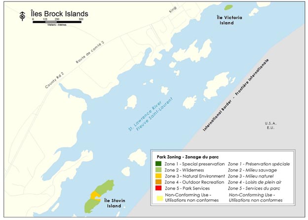
Map 3: Brock Islands Group — Text version
This is a map showing the zoning for the Brock Islands. There is a scale showing 0-500m.
Legend
Park zoning
- Zone 1 – special preservation
- Zone 2 – wilderness
- Zone 3 – natural environment
- Zone 4 – outdoor recreation
- Zone 5 – park services
- and one additional zone of non-conforming use.
Locations featured on the map are categorized by zone as follows:
- Stovin Island- zones 2 and 3.
- Victoria Island - zone 2.
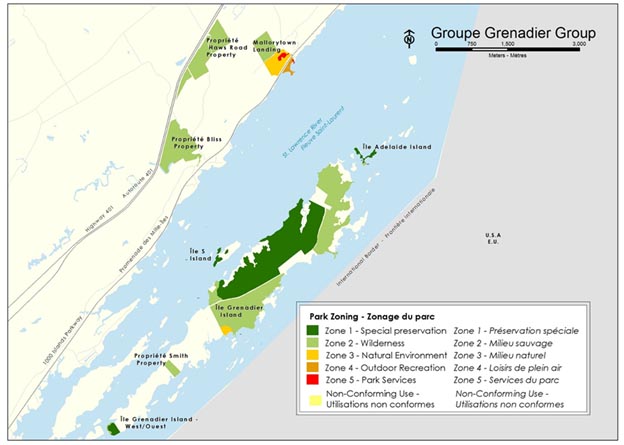
Map 4: Grenadier Group — Text version
This is a map showing the zoning for the Grenadier Group. The scale shows 0-1000 meters.
Legend
Park zoning
- Zone 1 — Special preservation
- Zone 2 — Wilderness
- Zone 3 — Natural Environment
- Zone 4 — Outdoor recreation
- Zone 5 — Park Services
- Non-conforming use
Locations featured on the map are categorized by zone as follows:
- Grenadier Island West – Zone 1
- Smith Property – Zone 2
- Grenadier Island – Zones 1, 2, and 3
- S Island – Zone 1
- Adelaide Island – Zones 1 and 2
- Bliss Property – Zone 2
- Haws Road Property – Zone 2
- Mallorytown Landing – Zones 2, 3, 4 and 5
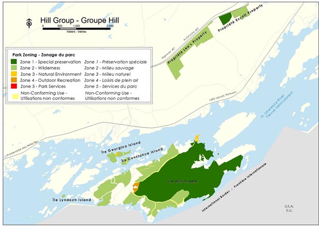
Map 5: Hill Group — Text version
This is a map showing the zoning for the Hill Group. The scale shows 0-1000 meters.
Legend
Park zoning
- Zone 1 — Special preservation
- Zone 2 — Wilderness
- Zone 3 — Natural Environment
- Zone 4 — Outdoor recreation
- Zone 5 — Park Services
- Non-conforming use
Locations featured on the map are categorized by zone as follows:
- Lees Property – zone 2
- Escott Property – zones 1 and 2
- Georgina Island – zones 2, and 3
- Constance Island – zone 2
- Hill Island – zones 1, 2, 3 and 4
- Lyndoch Island – zone 2
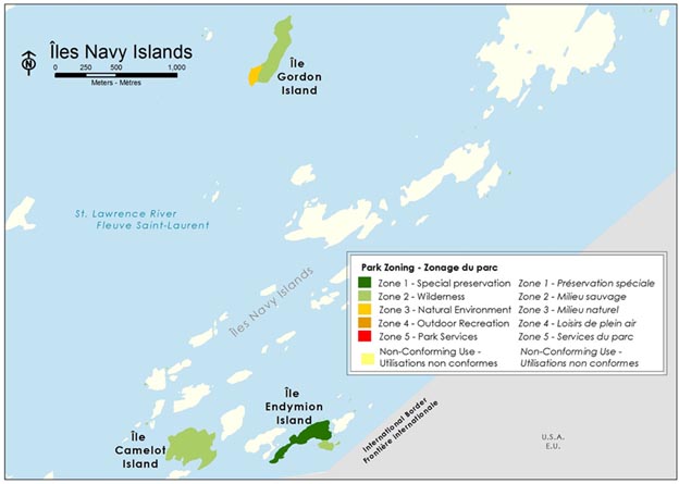
Map 6: Navy Islands Group — Text version
This is a map showing the zoning for the Navy Islands Group. The scale shows 0-1000 meters.
Legend
Park zoning
- Zone 1 — Special preservation
- Zone 2 — Wilderness
- Zone 3 — Natural Environment
- Zone 4 — Outdoor recreation
- Zone 5 — Park Services
- Non-conforming use
Locations featured on the map are categorized by zone as follows:
- Gordon Island – zones 2 and 3
- Camelot Island – zone 2
- Endymion Island – zones 1 and 2
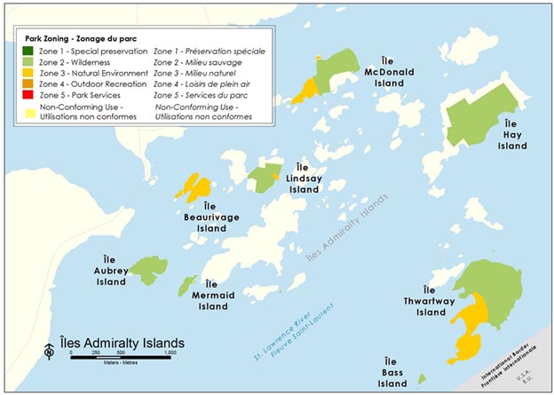
Map 7: Admiralty Islands Group — Text version
This is a map showing the zoning for the Admiralty Islands Group. The scale shows 0-1000 meters.
Legend
Park zoning
- Zone 1 — Special preservation
- Zone 2 — Wilderness
- Zone 3 — Natural Environment
- Zone 4 — Outdoor recreation
- Zone 5 — Park Services
- Non-conforming use
Locations featured on the map are categorized by zone as follows:
- McDonald Island – zones 2 and 3
- Lindsay Island – zones 2 and 3
- Thwartway Island – zones 2 and 3
- Bass Island – zone 2
- Beaurivage Island – zone 3
- Aubrey Island – zone 2
- Mermaid Island – zone 2
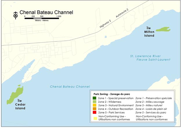
Map 8: Bateau Channel Group — Text version
This is a map showing the zoning for the Bateau Channel Group. The scale shows 0-1000 meters.
Legend
Park zoning
- Zone 1 — Special preservation
- Zone 2 — Wilderness
- Zone 3 — Natural Environment
- Zone 4 — Outdoor recreation
- Zone 5 — Park Services
- Non-conforming use
Locations featured on the map are categorized by zone as follows:
- Cedar Island – zone 2
- Milton Island – zone 2
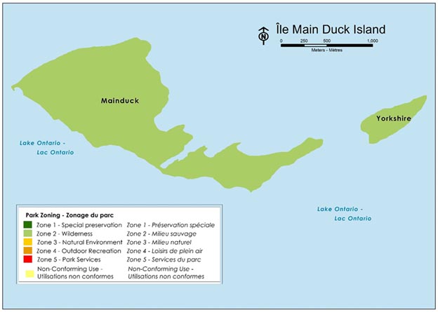
Map 9: Main Duck Islands Group — Text version
This is a map showing the zoning for the Main Duck Islands Group. The scale shows 0-1000 meters
Legend
Park zoning
- Zone 1 — Special preservation
- Zone 2 — Wilderness
- Zone 3 — Natural Environment
- Zone 4 — Outdoor recreation
- Zone 5 — Park Services
- Non-conforming use
Locations featured on the map are categorized by zone as follows:
- Main Duck Island
- Yorkshire Island
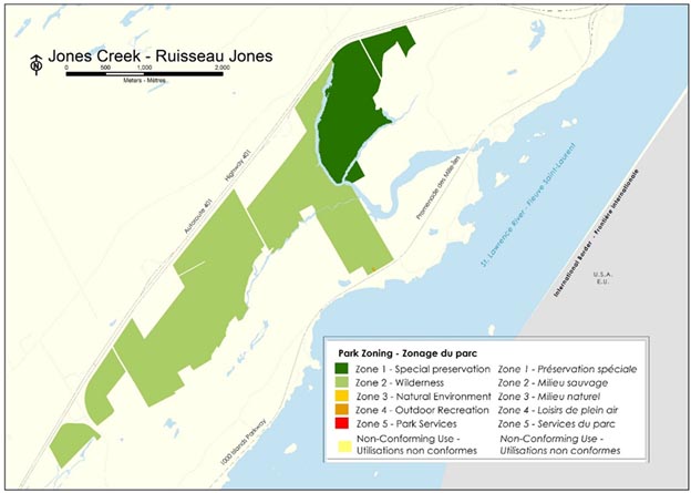
Map 10: Jones Creek — Text version
This is a map showing the zoning for Jones Creek. The scale shows 0-2000 meters.
Legend
Park zoning
- Zone 1 — Special preservation
- Zone 2 — Wilderness
- Zone 3 — Natural Environment
- Zone 4 — Outdoor recreation
- Zone 5 — Park Services
- Non-conforming use
Locations featured on the map are categorized by zone as follows:
- Jones Creek Property – zones 1 and 2
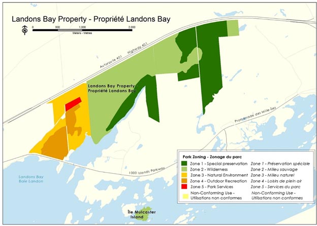
Map 11: Landons Bay Property — Text version
This is a map showing the zoning for Landons Bay and Mulcaster Island. The scale shows 0-2000 meters.
Legend
Park zoning
- Zone 1 — Special preservation
- Zone 2 — Wilderness
- Zone 3 — Natural Environment
- Zone 4 — Outdoor recreation
- Zone 5 — Park Services
- Non-conforming use
Locations featured on the map are categorized by zone as follows:
- Landons Bay Property – zones 1, 2, 3, 4, 5
- Mulcaster Island – zone 2
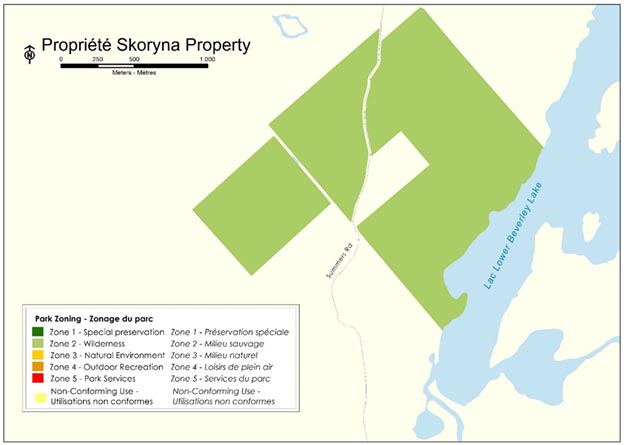
Map 12: Skoryna Property — Text version
This is a map showing the zoning for the Skoryna Property. The scale shows 0-1000 meters.
Legend
Park zoning
- Zone 1 — Special preservation
- Zone 2 — Wilderness
- Zone 3 — Natural Environment
- Zone 4 — Outdoor recreation
- Zone 5 — Park Services
- Non-conforming use
Locations featured on the map are categorized by zone as follows:
- Skoryna Property – zone 2
Summary of strategic environmental assessment
All national park management plans are assessed through a strategic environmental assessment to understand the potential for cumulative effects. This understanding contributes to evidence-based decision-making that supports ecological integrity being maintained or restored over the life of the plan. The strategic environmental assessment for the management plan for Thousand Islands National Park considered the potential impacts of climate change, local and regional activities around the park, expected changes in visitation and proposals within the management plan. The strategic environmental assessment assessed the potential impacts on different aspects of the ecosystem, including forests, freshwater, wetlands, and species at risk.
The forest ecosystem, 87% of the park, benefits from a good and stable current condition, and relative to other ecosystems, is less susceptible to external stressors. The visions and objectives from the management plan are expected to yield net positive environmental outcomes for the forest ecosystems at Thousand Islands National Park.
The freshwater shorelines and wetlands of Thousand Islands National Park are defining ecological features of the park, even though they make up a much smaller component. Many of the species at risk in the park depend on freshwater shorelines or wetlands. The longer term predictions of climate change suggest increasing pressure on the freshwater and wetland ecosystems. All of the streams that are monitored originate outside the park and thus are also subject to potential effects from future activities and other land uses outside the park boundaries, for example increased nutrient inputs from agriculture or golf course maintenance, or changes to flow from new non-permeable surfaces. Within the park, the infrastructure footprint in wetland ecosystems is minimal and impacts to freshwater can be mitigated. Between the management plan objectives and the implementation of strategic mitigations outlined in the strategic environmental assessment, potential negative effects from the management plan on freshwater and wetland ecosystems can be managed.
Thousand Islands National Park is home to over 40 species at risk assessed as endangered, threatened or special concern. More than 30 of those are listed on Schedule 1 of the Species at Risk Act. Thousand Islands National Park Multi-species Action Plan outlines the actions that will be taken to protect and recover these species. The strategic environmental assessment identified further mitigations for several species at risk.
Indigenous partners, stakeholders and the general public were provided with opportunities to provide comments on the draft management plan and a summary of the draft strategic environmental assessment. Feedback received has been incorporated into the strategic environmental assessment and management plan as appropriate.
The strategic environmental assessment was conducted in accordance with the Cabinet Directive on the Environmental Assessment of Policy, Plan and Program Proposals (2010) and facilitated an evaluation of how the management plan contributed to the Federal Sustainable Development Strategy. Individual projects undertaken to implement management plan objectives at the site will be evaluated to determine if an impact assessment is required under the Impact Assessment Act, or successor legislation. The management plan supports the following Federal Sustainable Development Strategy goals: Effective Action on Climate Change, Modern and Resilient Infrastructure, Pristine Lakes and Rivers, Sustainably Managed Lands and Forests, Healthy Wildlife Populations, and Connecting Canadians with Nature.
Many positive environmental effects are expected and there are no important negative environmental effects anticipated from implementation of the Thousand Islands National Park of Canada Management Plan.
Contact us
For more information about the management plan or about Thousand Island National Park of Canada:
Thousand Islands National Park
2 County Road 5, RR 3
Mallorytown ON K0E 1R0
Canada
Publication information
© Her Majesty the Queen in Right of Canada, represented by the President & Chief Executive Officer of Parks Canada, 2022.
Front cover image credit:
top from left to right: Parks Canada
bottom: Parks Canada
Cette publication est aussi disponible en français :
Plan directeur du parc national du Canada des Mille-Îles, 2022
- Paper: R64-578/2022E
- 978-0-660-38905-9
- PDF: R64-578/2022E-PDF
- 978-0-660-38905-9
Related links
- Date modified :