
State of the park assessment 2018
Quttinirpaaq National Park

Prepared by: Jenna Boon, Field Unit Superintendent, Nunavut Field Unit
Approved by:Trevor Swerdfager, Senior Vice-President, Operations
Table of contents
- Overview of Indicators- Quttinirpaaq National Park
- 1.0 Ecological Integrity Indicators
- 2.0 Cultural Resource Indicators
- 3.0 External Relations Indicators
- 4.0 Indigenous Relations Indicators
- 5.0 Visitor Experience Indicators
- 6.0 Built Assets Indicators
- 7.0 Key Issues
- Appendix 1: Species at Risk Indicators
Overview of Indicators- Quttinirpaaq National Park
Indicators
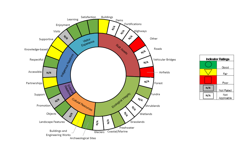
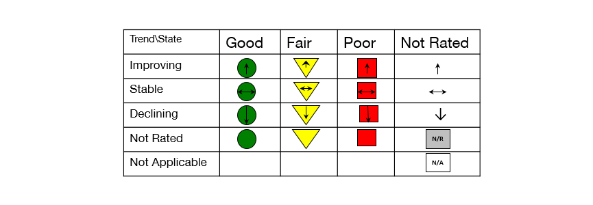
Legend
1.0 Ecological Integrity Indicators
Overview
This is the first Ecological Integrity (EI) assessment for Quttinirpaaq National Park. Following Agency direction for EI monitoring in northern parks, the EI monitoring program reports on two indicators: Tundra and Freshwater. The overall condition and trend assessment for Ecological Integrity is ‘good’ and considered ‘stable’.
Plant phenology is rated as “good” and “stable”. The program for the ground temperature, thaw tube and plant community measures is new and “not rated”, as there is insufficient data for analysis available, although a baseline can be determined. The water flow program has a longer dataset, but a baseline cannot be determined yet as data was not collected during the same time-frames. These issues are being addressed. Inuit Knowledge measures have not yet been developed for the park.
The overall trend for the Tundra Indicator is determined to be ‘stable’. The Circumpolar Active Layer Monitoring grid condition is rated as ‘good’, but with a declining trend. If the trend continues, it is anticipated that the condition will decrease to ‘fair’ by the next assessment. Continued monitoring is important as changes to the active layer will affect plant communities.
The Freshwater Indicator is determined to be ‘good’. It reports on data from the Ruggles, the outflowing river from Lake Hazen, in conjunction with mercury levels in Arctic char, rated as ‘good’ and ‘stable’. During the data analysis, it was noted that the water quality of inflowing rivers to Lake Hazen shows elevated levels of lead, zinc, iron and aluminum. Continued monitoring of the inflow rivers as well as the Ruggles is required to demonstrate whether these changes will impact water quality of the freshwater ecosystem. Encouraging research into the role of climate change on water quality may be beneficial. Including common elements for analysis between Arctic char contaminants and water quality measures may also be warranted.
National direction advises that EI monitoring occur within the same watershed. For historical reasons (i.e. pre-existing monitoring plots and data), the Tundra monitoring program is based at Tanquary Fiord. The Freshwater program is based at the Lake Hazen watershed as it is conducted in conjunction with Environment and Climate Change Canada. Plans to establish a Tundra program at Lake Hazen will depend on the operational capacity to support it.
Sources:
Resource Conservation, Nunavut Field Unit, Ecological Integrity measure assessment summary
Environment & Climate Change Canada, Derek Muir, Arctic Char Monitoring Data
Natural Resource Conservation Branch, Parks Canada National Office
Ecological integrity indicators
Tundra
Plant Phenology (2017)
Plant Community
Plant Productivity (2013)
Active Layer – CALM Grid (2017)
-- Ground Temperature
-- Thaw tube
Inuit Knowledge of Tundra
Freshwater
Water Quality (2016)
Water Flow/Gauging
Arctic Char Contaminants (2017)
Lake Ice On/Off / Phenology
Inuit Knowledge of Freshwater
2.0 Cultural Resource Indicators
Overview
Two waves of human migration have occurred over the past 5,000 years in what constitutes Quttinirpaaq National Park today. The artefacts, food caches, tent rings and subterranean houses left behind bear witness to this. In more recent history, polar explorers and military scientists have left behind signs of their presence and endeavours in Canada’s High Arctic.
Archaeological Sites
A total of 296 archaeological sites have been recorded. Their overall rating is ‘good’. The risk of disturbance by humans is low in most areas. Natural threats such as erosion, animal trampling and flooding exist, but are beyond Parks Canada’s control. Archaeological excavation and recording of sites particularly vulnerable to natural threats should be considered.
Buildings and Engineering Works
The overall rating for buildings and engineering works is ‘fair’. Out of a total of 38 buildings and engineering works located in the park, 31 are estimated to be over 40 years of age. Half of these originate from the Defence Research Board era between 1957-1962. Twelve of these assets have been assessed by the Federal Heritage Building Review Office (FHBRO) and came back as not classified. Evaluation under the Parks Canada Cultural Resource Management policy has yet to occur for assets that were not recommended for designation by the FHBRO or were not subjected to any evaluation.
In addition to the above are the three Greenlandic or Peary huts at Fort Conger. These are classified heritage buildings under the Treasury Board Policy on Management of Real Property. Regular monitoring has shown ongoing degradation; mitigation measures will need to be developed in the future.
Objects
Both historical and archeological objects are rated as ‘good’. Historical objects of importance have been catalogued and are housed in PCA’s archaeological collections facility in Winnipeg as well as the Canadian Museum of Civilization. A total of 14 artifacts were collected from sites vulnerable to natural disturbance for curation. The objects present at various sites in the park are considered to be in ‘good’ condition.
Landscapes and Landscape Features
These indicators are ‘not rated’ as not been identified yet.
Sources: Parks Canada Historical Objects Data at Tanquary Fiord 2017, Parks Canada Cultural Resources Monitoring DRB Collection 2013, CRM database for Quttinirpaaq, available literature (bibliography available)
Cultural resource indicators
Archaeological Sites
Archaeological Sites
Buildings and Engineering Works
Buildings and Engineering Works

Landscapes and Landscape Features
Landscapes and Landscape Features
Objects
Objects (Historical)
Objects (Archaeological)
3.0 External Relations Indicators
Overview
Quttinirpaaq National Park does not have dedicated External Relations staff to support outreach and engagement initiatives. More work directly involving the park’s adjacent communities is necessary to increase awareness about the park and to build a sense of place.
Promotion
Promotion is “not rated” because contacts can’t be specifically applied to this park as they are for all Nunavut parks. Quttinirpaaq was identified to develop a Northern Iconic Experience (NIE) in 2014. A significant amount of promotional work has been conducted to increase awareness about the NIE and the park in general.
Quttinirpaaq is featured annually at the Nunavut Trade Show and Conference, the Toronto Outdoor And Adventure Show, the Northern Lights, the Kitikmeot and the Kivalliq Tradeshows to actively promote and increase awareness about the park. Quttinirpaaq is also actively featured in print and social media. Since 2009, 188 articles have been published about the park.
Google Street View Imagery captured in 2016 was showcased in Grise Fiord and Resolute Bay and launched online in 2017. The pro-active media reached over 1.5 billion people via print, online articles, broadcasts, radio interviews, and social media snapshots.
Since 2015, Quttinirpaaq has maintained an active partnering agreement with Blackfeather Outfitters in order to jointly promote and facilitate experiences in the park.
Support
Since 2015, QNP has been offering the Chef at the Top of The World volunteer opportunity. Two or three individuals per year have volunteered their time to support camp operations by cooking for staff. In exchange, volunteers have been able to learn about the park first hand and participate in staff activities such as EI monitoring or backcountry patrols.
Two student volunteers and two chaperones from Resolute Bay and Grise Fiord spent time in the park in 2017. This was the first direct student visit to the park since 2009. Students and chaperones learned about park operations, and provided support where possible.
Sources: Annual Management Implementation Reports for Quttinirpaaq National Park 2010-2013
Nunavut Field Unit records managed by External Relations Team
National Office Media Team.
External Relations indicators
Promotion
Events
Support
Volunteers

4.0 Indigenous Relations Indicators
Indigenous Partnerships
Quttinirpaaq National Park is managed cooperatively through advice from the Joint Park Management Committee (JPMC). The Inuit Impact and Benefit Agreement (IIBA) for Auyuittuq, Quttinirpaaq and Sirmilik National Parks defines the terms and conditions of cooperative management. Parks Canada has been able to establish positive working relations with the members of the JPMC. Members were provided with a survey to give their input with respect to the ratings on this page. Trends are not provided for the ratings due to a very small data set.
Indigenous Accessibility
This indicator is ‘not rated’. The park area has not been inhabited by Inuit for over 800 years. Due to the physical distance (650-800km) between the park and its adjacent communities, Inuit rarely have opportunity to access it. Traditional activities are rarely performed.
Mutual Respect
Working relations with the JPMC are ‘good’ as demonstrated through active participation in meetings as well as members’ interest in remaining on the board for multiple terms. Five out of six board members are Inuit. Parks Canada presence in Resolute and Grise Fiord is sporadic, but reception of staff is typically positive. Relationship building is practiced through collaboration and cooperation.
Incorporation of Traditional Knowledge
Since Inuit have not lived or pursued traditional activities in the park, traditional knowledge has not been incorporated into the park’s management to date. Inuit values however, are incorporated through the cooperative management model. Use of Indigenous Language is rated ‘fair’ and ‘improving’. All public documentation is translated into Inuktitut. Inuit are encouraged to speak Inuktitut in the workplace however it is not the day-to-day working language.
Support for Indigenous Communities
This indicator is rated as ‘fair’ and ‘stable’. The park’s current organizational structure limits capacity building. To date, support and capacity building are mainly in the form of seasonal employment (no year-round positions other than the park manager exist) and short-term contracting opportunities. Other, minor economic spin-offs are from tourism to the park (visitors overnight in Resolute).
Sources: Inuit Impact and Benefit Agreement for Auyuittuq, Quttinirpaaq and Sirmilik National Parks, Field Unit statistics on employment, contracting Survey for QJPMC members
Indigenous Relations indicators
Indigenous Partnerships
Indigenous Collaboration in Heritage Place Planning and Management

Indigenous Collaboration in Heritage Place Operations
Indigenous Accessibility
Indigenous Partner Access to Heritage
Place Traditional Lands & Activities
Mutual Respect
Team Member Commitment to Building Mutual Respect, Trust and Understanding with Indigenous Partners
Extent of Reconciliation with Local Indigenous Communities
Incorporation of Traditional Knowledge
Incorporation of Traditional Knowledge
Use of Indigenous Languages
Support for Indigenous Communities
Economic Opportunities for Indigenous Peoples
Capacity Building for Indigenous Peoples
5.0 Visitor Experience Indicators
Overview
Visitor numbers to Canada’s most northerly national park are low due to the high cost of travel in the north ($14,000 for round trip from Ottawa) complex logistics and time required (2-3 days travel one way) to get there. In spite of this, the park receives visitors every year. 2007-08 is considered the base year for visitation throughout Parks Canada—that year 138 visitors came to Quttinirpaaq.
The trend for visits is ‘not rated’ because the trend rating is based on the average visitation for the last 5 years (51) compared to the base year (2007-08 of 138). A rating would demonstrate a significant downward trend, which is not a true representation of the actual trend, as cruise years and non-cruise years should not be compared. Trends are rated where data from post trip surveys are available in spite of a small sample size. Three additional measures are ‘not rated’ because they were not included in the survey, or did not apply to the park. Visitor Information Programs (VIPs) are not conducted in Nunavut and as such, are not available for the park.
Visits
The number of visits to Quttinirpaaq is heavily influenced by the availability of transportation: cruise ships and charter flights are the only way visitors can access the park. 2007 was a cruise ship year for Quttinirpaaq. Between 2008 and 2017, cruise ships visited the park three times. The average annual visitation to the park in these cruise ship years was 215. The average annual visitation for the park in the 7 years when cruise ships did not visit was 17 visitors.
Enjoyment
Post trip surveys were completed by 22 visitors between 2012 and 2017. 22 out of the 22 respondents totally agreed with the statement that “This place is meaningful to me.” Some of the words they used to describe this sentiment included “unique”, “wilderness”, “beautiful”, “top of the world”, “remote” and “untouched”.
Areas that received the highest ratings included cleanliness of outhouses, satisfaction with park staff conveying knowledge of the park, courteous park staff, service in the official language of choice, demonstrating a passion for the park, and condition of park facilities.
Learning
20 of the 22 respondents totally agreed with the statement “Thanks to my visit, I have learned something about the natural heritage of this park.”
Staff orientations and general interactions with staff were considered important to this learning. People indicated that they would be interested in learning more about geology, glaciers and climate change, history and wildlife. Efforts are underway to create a self-guided walking tour of a culturally significant area in the park as well as a pamphlet on local geology.
Sources: Parks Canada Attendance Reports Dashboard
Visitor Experience indicators
Visits
Attendance (person-visit)
Enjoyment
Enjoyed Visit
Satisfaction with Availability of Services
Satisfaction with Availability of Activities
Satisfaction with Staff Demonstrating Passion
Satisfaction with Condition of Facilities
Learning
Learned Something
Satisfaction
Overall Visit Satisfaction
Satisfaction with Information Prior to Arrival
Satisfaction with Value for Entry Fee
6.0 Built Assets Indicators
Overview
Quttinirpaaq National Park has 3 basecamps located within the park. The camps were established as part of the Defence Research Board’s (DRB) scientific work on Ellesmere Island during the 1950s and 60s. They are still in use for park operations today. Each camp has an airstrip, and buildings serve as kitchens, accommodations, or storage.
Buildings
There are a total of 29 buildings in the park. The Facility Condition Index (FCI) for buildings is ‘fair’ and ‘declining’. Tanquary Fiord is the main operations camp during the summer season. 7 buildings at Tanquary are available for visitors or other user groups (i.e., scientists, military). These include two accommodation buildings, a kitchen, outhouses, an interpretive centre and a solar shower. Many of the original DRB buildings are still in use for park operations today.
There are 9 buildings at Lake Hazen, including a laboratory owned by the University of Calgary as well as a shed that will require demolition. The buildings at Lake Hazen are frequently used by and shared with science groups in support of Quttinirpaaq’s long standing history and mandate to foster scientific research in Canada’s high arctic.
Ward Hunt Island has a camp with 7 buildings, including a laboratory owned and operated by Université Laval’s Centre for Nordic Studies.
Parks Canada has been able to maintain and upgrade infrastructure during periods of time when additional funding has been available, ex., the 2010-11 Arctic Research Infrastructure Fund. Since 2015, $500,000 has been invested to upgrade infrastructure at Tanquary Fiord, the park’s main operations base to support increased visitation and to meet Occupational Health and Safety requirements, using Federal Infrastructure Initiative. Plans are underway to address shortfalls in the other two camps, which are primarily used to support academic researchers and their science programs in the high Arctic.
Airstrips
Staff, scientists and visitors access the park by air, using one of the 3 airstrips available. A fourth airstrip exists at Fort Conger, a historic site within the park. This strip is rarely used and unmaintained. Maintenance on all airstrips has been sporadic, depending on staff availability and knowledge in the use of equipment. The FCI for 2 of the 4 airstrips is ‘poor’. Due to weather and difficulties accessing the airstrip at Ward Hunt, it has yet to be assessed. Regular basic maintenance on the three airstrips is critical to perform safe park operations and to be able to safely and effectively deliver on all aspects of the Agency’s mandate.
Other
Tanquary Fiord has a water reservoir built by the DRB in the 1960s. The reservoir is critical to park operations during the summer months. It was breached in 2011 and repaired temporarily by staff on site. While these repairs are still holding, the dam needs to be reinforced properly. The FCI for this structure ‘poor’. Plans are underway to repair the reservoir by 2020 as well as to explore alternative water sources.
Sources: Maximo, November 2017 NFU files
Built Assets indicators
Buildings
All types, including visitor or other user accommodations
Airstrips
Airfield

Other
Water reservoir
7.0 Key Issues
Issue 1: Meeting obligations under the Nunavut and Inuit Impact and Benefit Agreements (IIBA)
Indigenous partnerships, providing economic opportunities for indigenous people and building capacity in the form of employment have all received a ‘fair’ rating. Community engagement, recruitment and contracting/procurement within a federal and land claim context are complex and the operational model and associated funding level of Quttinirpaaq limit the ability to deliver on the obligations outlined in the Nunavut and Inuit Impact and Benefit Agreements (IIBA).
*Note that the IIBA is currently undergoing a review as required by law every seven years. Whether this review will have an impact on the park is unknown at this time.
Issue 2: Delivery on asset maintenance
The overall rating for all assets in the park is either ‘fair’ or ‘poor’ with a downward trend. The current operational model and associated funding level of Quttinirpaaq put the Nunavut Field Unit and the Agency at risk with respect to the Health and Safety of staff and other users of the park’s infrastructure. The park’s assets play a critical role in the success of continuing existing collaborations with other stakeholders, such as the scientific community, the military as well as the visiting public. Engagement with the science community in particular is critical to the successful delivery of the park’s EI monitoring program. Providing adequate facilities to visitors is imperative to the continuing success of the visitor offer.
Issue 3: Impacts of climate change
Climate change poses a significant risk to Quttinirpaaq operations. Assets, cultural and natural resources, visitor and staff safety as well as the safety of other users (researchers, the military, other government bodies) are all at risk to be impacted by climate change in the future. No clear strategy or direction exists on how to assess, mitigate and address this risk.
Issue 4: Consideration of all park users & impacts on the park
Visits to the park are ‘not rated’ in this assessment. While actual visitor numbers are low, Quttinirpaaq has relatively high numbers of other users not captured. These are primarily military and scientific personnel. An average of 40-50 military personnel and 15 scientists use the park as well as its facilities every year, including Environment and Climate Change Canada staff. Tanquary Fiord regularly sees air traffic (landings and take-offs, refueling of aircraft, overnighting of personnel) in support of scientific and military activities in the vicinity. The funding model of Quttinirpaaq does not account for this added strain on staff and the park’s infrastructure.
Appendix 1: Species at Risk Indicators
Porsild’s Bryum (Haplodontium macrocarpum) Conservation Target 1
Target: Survey site to determine baseline, identify threats
Outcome: Not Initiated (Funding not available to date)
Porsild’s Bryum (Haplodontium macrocarpum ) Conservation Target 2
Target: Develop long term monitoring program
Outcome: Not Initiated (Baseline information required first )
The 3 categories for Species at Risk reporting:
Reached: All actions are completed and conservation target is reached.
Partial: Some actions are completed but conservation target is not yet reached.
Not initiated: No actions have been implemented.
Changes in species conservation status or trends
3 species at risk: Peary Caribou-endangered; Porsild’s Bryum-threatened; Polar Bear-Special Concern. Peary Caribou population trend is unknown. Porsild’s Bryum has 8 populations located in 3 sites in the Tanquary Fiord area; trend unknown. Polar bear-Arctic Basin subpopulation is data deficient for population and trend.
Key information and threats
Porsild’s Bryum: Specific threats for park population have not been identified. Overall species threats include recreational activities, stochastic events and climate change related factors such as drought (reduced water seepage) and temperature extremes.
Peary Caribou: Most serious threat is climate change. The identification of critical habitat is outstanding for the park area.
Polar Bear: The recent analysis of the sub-population (Kane Basin) density nearest to the Arctic Basin sub-population suggests a stable to increasing abundance with an increasing range. Impacts of climate change may initially benefit the Kane Basin sub population before causing negative effects.
Results of management actions
Porsild’s Bryum: Populations have not been surveyed since 2004. Mitigation measures for outfitter business licences have been developed to ensure guides and their clients do not inadvertently impact the colonies.
Completion of recovery documents or other legal requirements
Porsild’s Bryum: Approved Recovery Strategy. Action Plan awaiting posting. Critical habitat identified for park listed in Canada Gazette (January 2017).
Peary Caribou: No approved Recovery Strategy or Action Plan.
Polar Bear: No approved management plan.
Sources: Information extracted from Biotics, Recovery Strategies, draft plans
- Date modified :