
Geology
Kejimkujik National Park and National Historic Site
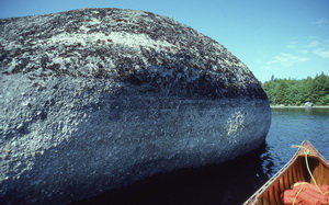
Photo: J. Brownlie
Kejimkujik is located on the Southern Upland Region of Nova Scotia. This area is a flat plain lacking the major escarpments, mountains and valleys found in other parts of the province. However, the park contains examples of many smaller surface features created during the last glacial stage.
Giant boulders, boulder fields, long winding eskers and drumlin hills are easily observed, while kames and outwash plains are less obvious and relatively inaccessible. Following glaciation, the formation of numerous shallow lakes, connected by wandering rivers, made southwestern Nova Scotia the best canoeing country in the province.
Bedrock
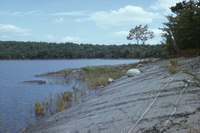
Photo: P. Hope
Most of the more visible landforms seen in Kejimkujik are a direct result of the last glaciation, which started approximately 100,000 to 80,000 years ago. Drumlins, shallow lakes, streams, rivers and granite boulders are all the result of glacial action. This glacial action was greatly influenced by the bedrock beneath the ice sheets. Most glacial landforms are in areas with slate bedrock, as it is soft and easily eroded.
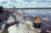
Photo: P. Hope
The bedrock consists of Precambrian to Ordovician period quartzite and slate, plus Devonian period granite. All of these rocks, especially quartzite, have high silica content and provide scanty amounts of nutrients to the soils that develop on them. The slate, however, is fine-grained and produces a loamy soil which yields its nutrients more quickly than the stony sandy loams and loamy sands found over the coarse-grained rocks. Most of the slaty loams occur around Kejimkujik Lake. Deep outwash sands and gravels form a band west of the lake. Elsewhere the soil landscape is dominated by the cobbly, often shallow granite or quartzite material.
Glacial features
Drumlins
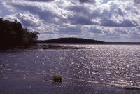
Photo: P. Hope
Drumlins are smooth, oval hills with a steeper, blunt end facing the oncoming glacier, and a gentle slope pointing in the direction of ice movement. The drumlins in Kejimkujik all trend southeastwards, indicating the direction of the strongest ice advance was from the northwest to the southeast. They were formed when a large accumulation of eroded material was deposited underneath the ice. The glacier then continued to move up and over this material, moulding it into the streamlined drumlin shape.
Erratics
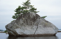
Photo: P. Hope
The gently rolling hills of Nova Scotia’s interior represents the Atlantic Coast Plain, a land of folded metamorphic rock, polished and grooved by retreating glaciers that exposed stony, shallow soil and left behind erratics - huge granite boulders carried by the migrating ice then strewn about as the ice melted. Many such ice-transported boulders are strewn throughout Kejimkujik. Look for them along lakesides and trails.
Eskers
Eskers are long, sinuous ridges formed by the deposition of material in an ice tunnel carved at the base of a glacier by meltwater streams. Long eskers occur along the northern margin of Kejimkujik and also along West River.
Lake basins
Kejimkujik is underlain by two main types of rock; a granite terrane and a sedimentary terrane comprised of slate and quartzite. The granite landscape appears as a higher upland while the sedimentary areas are lower and more level. Glaciation has stripped away ancient soils and scooped out easily eroded bedrock to form lake basins. Today, the numerous lakes, their basins scooped out as the ice retreated, comprise about 15 percent of the area.
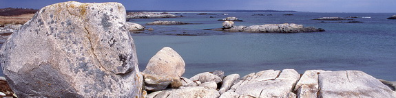
Kejimkujik Seaside
With its kilometres of exposed coastline, the Seaside is a haven for those visitors interested in geology.
Ancient geology
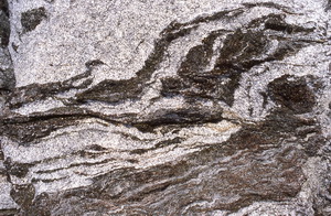
Photo: P. Hope
The rocks which make up Kejimkujik’s Seaside are very similar to those found in Kejimkujik inland. White granites and quartzites line the headlands and feed the cobble and rocky beaches. The granite is part of a major geological event that shaped western Nova Scotia. Known today as the North Mountain batholith, this enormous bubble of magma rose from the Earth’s interior. It ate its way into the existing rocks by following cracks and weaknesses and by heating and melting the rock. The intense heat generated by the magma caused the existing sandstones and slate to change, or metamorphose into quartzites and greywackes.
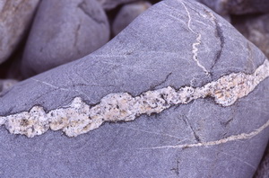
Photo: J. Brownlie
Where the magma followed cracks and fractures, linear veins, dykes, and sills cut across older rocks. On the headlands veins and dykes of granite cutting through the darker metamorphic quartzites and greywackes are visible. The contact of this molten granite changed the metamorphic rocks in many interesting and observable ways.
The oldest rocks in the metamorphic greywackes and quartzites, are Cambrian in age, or 550 million years old. The granite is Carboniferous in age, or 352 million years old.
Ice Age
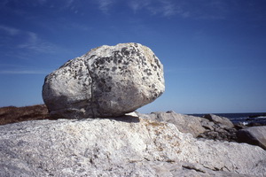
Photo: P. Hope
The Ice Age also left its mark on Kejimkujik’s Seaside. The ice retreated from this area about 13, 000 years ago; almost 2,000 years before the inland portion of Kejimkujik. In some areas, the bedrock has been polished smooth when glaciers flowed over them. Thousands of large erratic boulders stick out through bogs and barrens, just where the melting glaciers dropped them. The soil of this land is often just a thin veneer of glacial till, composed of a mixture of sand, rock, and gravel that were left behind by the glaciers. It lacks many nutrients. The presence of thicker patches of soil determine where forests will grow as the trees prefer growing on deeper and more well-drained till.
During glaciation, sea levels were below present levels. Much of the world’s water had been removed from the ocean and captured in the form of ice. But, the Seaside contains visible evidence of a dramatic change in sea level. A walk along the shoreline at Harbour Rocks will reveal peaty muds, fossilized tree stumps on beaches, and soil layers on rocky outcrops or islands. These features only form inland where plant material can slowly accumulate. Soil does not form where crashing waves of salt water wash everything away. Trees do not grow on beaches. In fact, the fossilized tree stumps may be many thousand years old and were preserved deep underground. The post-glacial history of Kejimkujik Seaside can be viewed as a continual encroachment of the marine environment on the land. In recent memory, off-shore islands such as Little Hope Island were vegetated and supported small farms. Evidence suggests that the sea level continues to rise at a rate of 30 centimetres a century on the south shore of Nova Scotia. Add this to the ocean level increase due to global warming and it is clear that the Seaside’s coastline is going to continue to change.