Kejimkujik National Park and National Historic Site of Canada Management Plan, 2022
Note to readers
The health and safety of visitors, employees and all Canadians are of the utmost importance. Parks Canada is following the advice and guidance of public health experts to limit the spread of COVID-19 while allowing Canadians to experience Canada’s natural and cultural heritage.
Parks Canada acknowledges that the COVID-19 pandemic may have unforeseeable impacts on the Kejimkujik National Park and National Historic Site of Canada Management Plan. Parks Canada will inform Indigenous peoples, partners, stakeholders and the public of any such impacts through its annual implementation update on the implementation of this plan.
The Honourable Steven Guilbeault, P.C., M.P.
Minister of Environment and Climate Change and Minister responsible for Parks Canada
From coast to coast to coast, national historic sites, national parks and national marine conservation areas are a source of shared pride for Canadians. They reflect Canada’s natural and cultural heritage and tell stories of who we are, including the historic and contemporary contributions of Indigenous peoples.
These cherished places are a priority for the Government of Canada. We are committed to protecting natural and cultural heritage, expanding the system of protected places, and contributing to the recovery of species at risk.
At the same time, we continue to offer new and innovative visitor and outreach programs and activities to ensure that more Canadians can experience these iconic destinations and learn about history, culture and the environment.
In collaboration with Indigenous communities and key partners, Parks Canada conserves and protects national historic sites and national parks; enables people to discover and connect with history and nature; and helps sustain the economic value of these places for local and regional communities.
This new management plan for Kejimkujik National Park and National Historic Site of Canada supports this vision.
Management plans are developed by a dedicated team at Parks Canada through extensive consultation and input from Indigenous partners, other partners and stakeholders, local communities, as well as visitors past and present. I would like to thank everyone who contributed to this plan for their commitment and spirit of cooperation.
As the Minister responsible for Parks Canada, I applaud this collaborative effort and I am pleased to approve the Kejimkujik National Park and National Historic Site of Canada Management Plan.
Recommendations
Recommended by:
Ron Hallman
President & Chief Executive Officer
Parks Canada
Andrew Campbell
Senior Vice-President, Operations Directorate
Parks Canada
Eric Nielsen
Superintendent, Mainland Nova Scotia Field Unit
Parks Canada
Executive summary
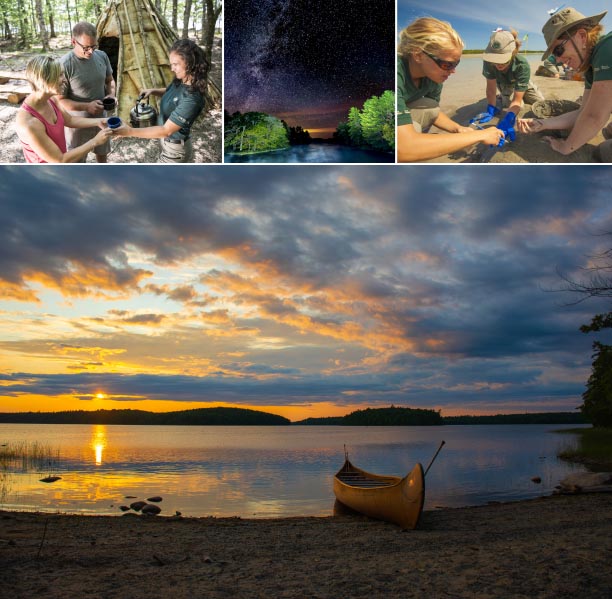
Kejimkujik National Park and National Historic Site is a place where, for generations, people have connected to nature and culture in a landscape of forests, lakes, rivers and the Atlantic coast. Kejimkujik has a profound ecological and cultural significance to the Mi’kmaq, and has significance as a place of recreation, respite and connection for both new and returning visitors, and to local communities with deep historical connections.
Kejimkujik National Park and National Historic Site is situated in unceded traditional Mi’kmaw territory, also known as Mi’kma’ki, and is the first national park in Canada where the majority of the park is also a national historic site. Kejimkujik is of great importance to the Mi’kmaq of Nova Scotia as a cultural landscape, used by the Mi’kmaq for millennia through to today; this importance was recognized formally through a 1995 designation as a national historic site. Kejimkujik was first designated as a national park, protecting a representative example of the Atlantic Coast Uplands Natural Region in 1974. An additional area along the Atlantic Coast, now known as Kejimkujik National Park Seaside (Kejimkujik Seaside), was added to the national park designation in 1985 and protects an outstanding coastal wilderness.
Kejimkujik occurs over two distinct parcels of land: Kejimkujik Inland and Kejimkujik Seaside. Kejimkujik Inland is located in the centre of Kespukwitk, or southwest Nova Scotia, about a two-hour drive from Halifax, between Bridgewater and Annapolis Royal. A biodiversity hotspot characterized by forests, including old-growth hemlocks, lakes and wetlands, Kejimkujik Inland is a well-loved destination for camping, canoeing and wilderness adventure, with multiple generations of visitors returning year after year. Kejimkujik Seaside is located about 100 kilometres by road from Kejimkujik Inland, to the west of Liverpool at the Atlantic Ocean end of the traditional Mi’kmaw route and along the Mersey River corridor. It is largely a self-guided destination for coastal adventure, with stunning views, sandy and cobble beaches, coastal wetlands and headlands, estuaries and lagoons.
This management plan was developed to replace the 2010 management plan. It strives to reflect Parks Canada’s strong desire to work cooperatively with the Mi’kmaq of Nova Scotia to ensure a shared approach to the management of Kejimkujik, in the spirit and intent of the Recognition of Indigenous Rights and Self-Determination negotiations currently underway. The significance of Kejimkujik to the Mi’kmaq as a Mi’kmaw cultural landscape underpins all management direction for the site.
As well, the management plan benefited from the input of stakeholders, visitors, local communities, tourism operators and organizations, local and regional economic development and conservation interests, the Province of Nova Scotia, and the Canadian public at large.
Four key strategies have been outlined, reflecting four key Mi’kmaw worldview concepts. These key strategies and associated objectives provide strategic management direction for Kejimkujik over the next ten years:
Key strategy 1
Kepmite’tmek — We respect — Protect
We are actively protecting a treasured and changing landscape
Key strategy 2
Netukulu’ltiek — We share stewardship — Conserve
We are collectively participating in the principle of sustainability through responsibility
Key strategy 3
Msit Ki’kamunaq — All of our relations — Connect
We are connecting the people with the place
Key strategy 4
Toqi’maliaptme’k — We cooperate and collaborate — Co-create
Together, we are the ones who are achieving results through co-creation and co-management
Introduction
Parks Canada administers one of the finest and most extensive systems of protected natural and historic places in the world. The Agency’s mandate is to protect and present these places for the benefit and enjoyment of current and future generations. Future-oriented, strategic management of each national historic site, national park, national marine conservation area and heritage canal administered by Parks Canada supports the Agency’s vision:
Canada’s treasured natural and historic places will be a living legacy, connecting hearts and minds to a stronger, deeper understanding of the very essence of Canada.
The Canada National Parks Act and the Parks Canada Agency Act require Parks Canada to prepare a management plan for each national park and national historic site. The Kejimkujik National Park and National Historic Site of Canada Management Plan, once approved by the Minister responsible for Parks Canada and tabled in Parliament, ensures Parks Canada’s accountability to Canadians, outlining how park management will achieve measurable results in support of the Agency’s mandate.
The Mi’kmaq of Nova Scotia are important partners in the stewardship of Kejimkujik, with connections to the lands and waters since time immemorial. The Mi’kmaq of Nova Scotia, stakeholders, local communities, tourism operators and organizations, local and regional economic development and conservation interests, the Province of Nova Scotia, as well as the Canadian public, were involved in the preparation of the management plan, helping to shape the future direction of the national park and national historic site. The plan sets clear, strategic direction for the management and operation of Kejimkujik National Park and National Historic Site by articulating a vision, key strategies and objectives. Parks Canada will report annually on progress toward achieving the plan objectives and will review the plan every ten years or sooner if required.
This plan is not an end in and of itself. Parks Canada will maintain an open dialogue on the implementation of the management plan, to ensure that it remains relevant and meaningful. The plan will serve as the focus for ongoing engagement and, where appropriate, consultation, on the management of Kejimkujik National Park and National Historic Site in years to come.
Significance of Kejimkujik National Park and National Historic Site
Kejimkujik, located in the unceded Footnote 1 traditional Mi’kmaw territory of Mi’kma’ki, is a place where, for generations, people have connected to nature and culture in a landscape of forests, lakes, rivers, and the Atlantic coast. Kejimkujik and the broader cultural landscape, including the Mersey River corridor, has a profound ecological and cultural significance to the Mi’kmaq. Kejimkujik also has significance as a place of recreation, respite and connection for both new and returning visitors, and to local communities with deep historical connections.
Kejimkujik was the first national park in the Parks Canada system where the majority of the park is also a national historic site. Although operating as a national park since 1969, the inland portion (Kejimkujik Inland) was officially designated as a national park in 1974 to protect a representative example of the Atlantic Coast Uplands Natural Region. In 1985, the seaside portion (Kejimkujik National Park Seaside, or Kejimkujik Seaside) was added to the designation to protect an area representative of the coastal characteristics of this natural region (Map 1).
Kejimkujik Inland was designated a national historic site in 1995 because it is a significant Mi’kmaw cultural landscape that attests to Mi’kmaw occupancy and use of the area from time immemorial. The Mi’kmaq of Nova Scotia worked closely with Parks Canada to seek this designation. Within the landscape, many important cultural resources can be found, including pre-contact habitation sites, post-contact reserve sites, petroglyphs, canoe routes and portages, fishing weirs and sacred sites.
In 2001, the Southwest Nova Biosphere Reserve was designated a UNESCO Footnote 2 demonstration area for conservation and sustainable development that encompasses the five surrounding counties, with its core protected area including Kejimkujik and the adjacent provincial Tobeatic Wilderness Area (Map 2).
In 2010, Kejimkujik was designated a dark-sky preserve by the Royal Astronomical Society of Canada, in recognition of its low levels of light pollution and its ability to connect people to the night skies.
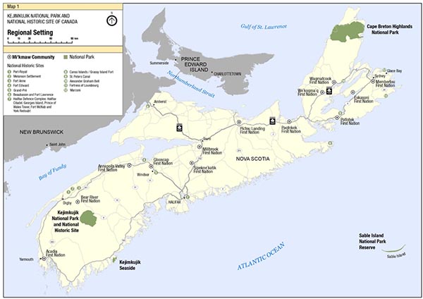
Map 1: Regional setting
A road map of Nova Scotia, showing the location of Kejimkujik National Park and National Historic Site. Kejimkujik National Park and National Historic Site is located in the South Shore Region of Nova Scotia, nestled inland near the village of Caledonia, about 167 km west of Halifax.
Kejimkujik Seaside is located along Nova Scotia’s coast, 99 km southeast of Kejimkujik National Park and National Historic Site and 180 km west of Halifax.
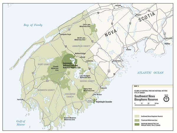
Map 2: Southwest Nova Biosphere Reserve
The Southwest Nova Biosphere Reserve is a UNESCO designated, and internationally recognized, unique region of natural and cultural heritage, spanning the five counties of Annapolis, Digby, Yarmouth, Shelburne and Queens. This Biosphere Reserve is one of only 16 in Canada. Both Kejimkujik National Park and National Historic Site and Kejimkujik Seaside are within the confines of the Biosphere Reserve.
Planning context
Kejimkujik is situated about a two-hour drive from Halifax in the unceded traditional Mi’kmaw territory of Mi’kma’ki, within the district of Kespukwitk, which is the Mi’kmaw name for southwest Nova Scotia meaning “land’s end” or “end of flow.” Kejimkujik is an important tourism attraction and economic driver in southwest Nova Scotia.
Kejimkujik Inland (381 square kilometres) is located about 65 kilometres from both Bridgewater and Liverpool, and about 50 kilometres from Annapolis Royal, with its entrance near the village of Caledonia (Map 3). Characterized by the Acadian forest ecosystem, with a multitude of lakes and rivers and old growth hemlock stands, Kejimkujik is a destination primarily for frontcountry and backcountry camping, wilderness canoeing, hiking and biking during the summer months. Although previously a winter recreation destination, the winter offer was reduced in 2012. Kejimkujik Inland has 344 camping sites in the frontcountry, 18 oTENTiks, five Ôasis dome-shaped sleeping pods, three rustic cabins and one yurt, and about 39 kilometres of frontcountry trails, while in the backcountry there are 46 camping sites, three cabins, 13.5 kilometres of portages accessing 20 of Kejimkujik’s approximately 40 lakes, and about 89 kilometres of backcountry trails. The lands surrounding the park include the provincial Tobeatic Wilderness Area, Shelburne River Wilderness Area, Lake Rossignol Wilderness Area, Medway Lakes Wilderness Area, and the nearby Katewe’katik Wilderness Area, and other provincial and private lands. The Friends of Keji Cooperating Association is an active partner at Kejimkujik Inland. A concession holder at Kejimkujik Inland, Whynot Adventure, supports guiding, frontcountry and backcountry camping, biking, stand-up paddle boarding, canoeing and kayaking.
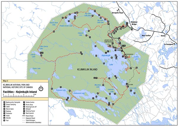
Map 3: Kejimkujik inland facilities
A detailed map of Kejimkujik inland facilities with icons marking each location for each of the facilities. These include:
Backcountry Campsites
Group Camping
Cabins
Patrol Cabins
Parking Areas
Fire towers
Kiosks
Otentiks
Yurts
Visitor Centre
Picnic Areas
Viewing and Look-off areas
Helipad
Viewing Tower
Boat Launch
Paved Roads
Unpaved Roads
Trails and Portages
Administrative Boundary for the Park
There is also a map scale bar to assist with measuring distances.
Kejimkujik Seaside (24 square kilometres) is located about 100 kilometres by road from Kejimkujik Inland on the Atlantic coast to the west of Liverpool, between Port Mouton and Port Joli (Map 4). Kejimkujik Seaside is an iconic destination for exploring Nova Scotia’s wild Atlantic coast, characterized by coastal barrens, headlands, cobble and sandy beaches, estuaries and lagoons. Since 2012, the seaside portion has been largely self-guided; although unstaffed, the site has high visitation and modest services and facilities including a parking lot, washroom facilities, hiking trails and beaches.
In recent years, visitation at Kejimkujik has increased. There was a dramatic 68 percent increase in attendance at Kejimkujik (Inland and Seaside combined) from the previous year to 60,650 visitors during the Canada 150 celebrations in 2017. The annual attendance further increased to 78,806 in 2018–2019, although an improved visitor attendance methodology may have contributed to that. The COVID 19 pandemic and facility closures due to infrastructure renewal disrupted visitation patterns in 2020 and 2021. Visitation at Kejimkujik Inland is largely repeat visitors, with about three quarters from Nova Scotia; at the seaside portion the majority of visitation is first-time visitors with about one quarter from Nova Scotia. At both Kejimkujik Inland and Kejimkujik Seaside, the majority of parties consist of adult-only groups. Kejimkujik is close to Halifax Regional Municipality, providing strong and innovative opportunities to tap new markets including new Canadians, urban dwellers and youth.
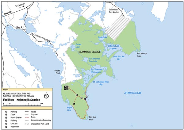
Map 4: Kejimkujik seaside facilities
A detailed map of Kejimkujik Seaside facilities with icons marking each location for each of the facilities. These include:
Parking Kiosk
Picnic Shelter
Pit Privy
Look-off
Washrooms
Paved Road
Unpaved Road
Trails
Administrative Boundary
Ungazetted Park Land
There is also a map scale bar to assist with measuring distances.
About $15 million was invested in Kejimkujik’s infrastructure between 2016 and 2021, including bridges, a new hiking and biking trail, maintenance of buildings and day-use areas. A significant project to upgrade washrooms and utilities at Jeremys Bay Campground occurred 2020–2021, showcasing energy efficiency and fuel switching, accessibility and principles of universal inclusion in infrastructure renewal.
Ecosystem indicators being monitored at Kejimkujik are largely green or in “Good” condition, with the exception of the coastal indicator, which is yellow or in “Fair” condition. Footnote 3 However, the ecological integrity of Kejimkujik is being affected by regional, large-scale factors including climate change and invasive species (e.g. hemlock woolly adelgid Footnote 4; invasive fish species including chain pickerel and smallmouth bass; green crab at Kejimkujik Seaside). Several species at Kejimkujik are currently listed under the Species at Risk Act, including Blanding’s turtle, eastern ribbonsnake, water pennywort and piping plover. Footnote 5 Parks Canada has received multi-year funding to better understand and respond to the threats of invasive species. Kejimkujik is within a Priority Place identified by Environment and Climate Change Canada for species at risk conservation under the Kespukwitk Conservation Collaborative, a recognized multi-stakeholder initiative focused on species at risk conservation across the broader landscape. This landscape-level approach has been facilitated by the well-established, collaborative nature of conservation in the larger landscape, for which Parks Canada has been an acknowledged leader. Kejimkujik managers have been proactive in responding to climate change, including holding a Climate Change Adaptation Workshop and action planning in response to current national priorities on this topic. “Two eyed seeing” (or Etuaptmumk, where both western and Mi’kmaw knowledge are woven together to inform all management decision making) will be important in developing the climate change resiliency of Kejimkujik.
Strategic relationships are vital to ensuring the successful operation and management of Kejimkujik. The Friends of Keji Cooperating Association, the park’s long-standing cooperative association, has the mandate to, “support Parks Canada’s mandate for the protection, preservation and interpretation of all the resources in Kejimkujik National Park and National Historic Site.” The Friends of Keji runs the gift shop, and firewood and food services at Kejimkujik Inland and supports the volunteer program. Many environmental research and conservation groups and organizations contribute to research and monitoring of ecosystems in Kejimkujik and the broader landscape, contributing to evidence-based ecosystem management. With Kejimkujik being surrounded by provincial crown lands, including several provincial wilderness areas, Parks Canada has the opportunity to participate in broader initiatives with other land managers, such as conservation and regional transboundary recreation. There are active partnerships for collaborative ecosystem research (e.g. Mersey Tobeatic Research Institute), and sustainable forest management (e.g. Medway Community Forest Cooperative). Parks Canada has the opportunity to support and work with local land managers, partners and local Mi’kmaw communities to advance the ecological and functional connectivity of the broader landscape. Connections between Kejimkujik managers and local communities and businesses near Kejimkujik Inland and Seaside are vital. The park draws tourism to the region, offering local communities opportunities to provide essential goods and services to visitors.
Parks Canada has a strong and growing relationship with the Mi’kmaq of Nova Scotia in Kejimkujik’s management, interpretation and monitoring programs. The aspiration is for continued development of this relationship, with Parks Canada and the Mi’kmaq of Nova Scotia cooperating and co-creating shared approaches to the management of Kejimkujik over the life of this plan and beyond. Several Mi’kmaw people are employed at Kejimkujik, and there have been recent successful collaborative projects including birch bark harvesting and birch bark canoe building, Indigenous tourism and collaborative archaeology. Guidance on management direction on matters of interest to the Mi’kmaq (e.g. key projects, collaborations and opportunities for economic benefit) is provided by the Mainland Nova Scotia Mi’kmaq-Parks Canada Advisory Committee, a structure established with local Mi’kmaw community representation under an Interim Arrangement with the Mi’kmaq of Nova Scotia. Established in 2012 and renewed in 2017, the Interim Arrangement describes the relationship between Parks Canada and the Mi’kmaq of Nova Scotia while Recognition of Indigenous Rights and Self-Determination negotiations are ongoing. The Interim Arrangement will be replaced once these negotiations are concluded. The management plan has been prepared in anticipation of this, in the spirit and intent of the rights implementation negotiations.
Because of Kejimkujik’s dual designation as both a national park and a national historic site, Parks Canada seeks to ensure both its ecological integrity and commemorative integrity. In fact, there is an emerging understanding that at Kejimkujik one cannot exist without the other. The Canada National Parks Act defines ecological integrity for a national park as,
a condition that is determined to be characteristic of its natural region and likely to persist, including abiotic components and the composition and abundance of native species and biological communities, rates of change and supporting processes.
Commemorative integrity refers to the condition or state of a national historic site when the site has retained the heritage value for which it was designated; this is the desired state for a national historic site. According to Parks Canada’s Cultural Resource Management Policy, a national historic site possesses commemorative integrity when:
the resources directly related to the reasons for designation as a national historic site are not impaired or under threat;
the reasons for designation as a national historic site are effectively communicated to the public; and
the site’s heritage values (including those not related to the reasons for designation as a national historic site) are respected in all decisions and actions affecting the site.
Development of the management plan
The management plan for Kejimkujik has been prepared in consultation with the Mi’kmaq of Nova Scotia, and with key stakeholders and site partners including the Friends of Keji Cooperating Association, the Royal Astronomical Society of Canada, the Mersey Tobeatic Research Institute and other conservation organizations in the Kespukwitk Conservation Collaborative, environmental organizations, local communities, local and regional economic development organizations and interests, tourism operators and interests and the Province of Nova Scotia.
During the development of the management plan, the Mi’kmaq of Nova Scotia were engaged, and the plan was developed in the spirit and intent of the Recognition of Indigenous Rights and Self-Determination negotiations, with strong consideration given to key principles expressed by the Mi’kmaq. Parks Canada met with Kwilmu’kw Maw-klusuaqn Negotiation Office, the Mainland Nova Scotia Mi’kmaq-Parks Canada Advisory Committee, and the Confederacy of Mainland Mi’kmaq during the course of development of the plan, and their input has shaped this final plan.
The management plan was prepared following two periods of public engagement. During the first phase, held during spring-summer 2019, ideas and reactions were solicited on a draft vision and on a series of topics. During the second phase, held summer 2021, reaction on a draft plan was sought. An online engagement platform was created (Let’s Talk Kejimkujik!) that encouraged participation in surveys at each phase, as well as the sharing of ideas and stories. This website was promoted to visitors by Parks Canada staff at Kejimkujik, by Parks Canada Learn-to Camp and Outreach teams in Halifax and elsewhere, through social media, and during public engagement sessions. The website was complemented by a multi-stakeholder session, a staff session, meetings with Kejimkujik Seaside neighbours and stakeholders, and bilateral meetings with key stakeholders including Mersey Tobeatic Research Institute and Friends of Keji. In all, over 3,000 people were engaged during the process, and about 400 people responded to the online surveys. The COVID-19 pandemic caused delays in the preparation of the draft plan and consequently delays in consultation and finalizing the plan.
Vision
The vision presented below expresses the future desired state of Kejimkujik National Park and National Historic Site in 15 to 20 years. The vision has been updated from the 2010 management plan, in consultation with the Mi’kmaq of Nova Scotia, stakeholders and Canadians, and was refined through further consultation and engagement during the development of this management plan.
From the rich diversity of forests, lakes and rivers of the interior to the headlands and beaches of the rugged coastline, Kejimkujik National Park and National Historic Site, including Kejimkujik Seaside, is a place where the people have shaped the land and the land has shaped the people since time immemorial.
At the centre of the Mi'kmaw District of Kespukwitk (meaning "Land's End") and the Southwest Nova Biosphere Reserve, Kejimkujik is a place where nature and culture are inseparable, and where both are protected, respected, and celebrated.
Kejimkujik is a place where nature and culture will be resilient in a changing world, and where everyone can develop a deep connection and sense of belonging.
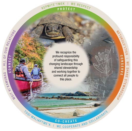
Figure 1: Kejimkujik vision
The vision for Kejimkujik is presented in graphic format, principally a circle with text above and text inside the circle.
The text inside the circle reads:
We recognize the profound responsibility of safeguarding this changing landscape through shared stewardship and working together to connect all people to this place.
Around the circle there are four concepts:
Kepimite’tmek/We respect (Protect)
Netukulu’ltiek/ We share stewardship (Conserve)
Toqi’maliaptme’k/We cooperate and collaborate (Co-create)
Msit Ki’kamunaq/All of our relations (Connect).
Key strategies
The four key strategies reflecting four Mi’kmaw worldview concepts of the vision frame the management direction for Kejimkujik for the next 10 years. The strategies and corresponding objectives and targets focus on achieving the vision for Kejimkujik through an integrated approach to site management. Targets have been prioritized with specific dates where feasible. Where no dates have been referenced, the target will be achieved within the life of the plan based on opportunities, annual priorities and capacity of Parks Canada. Annual implementation updates will be provided to the Mi’kmaq of Nova Scotia, partners, stakeholders and the general public.
Key strategy 1 Kepmite’tmek — We respect — Protect
We are actively protecting a treasured and changing landscape
Being both a national park and a national historic site, the primary management aim for Kejimkujik is to conserve its ecological integrity and maintain its commemorative integrity. Healthy and resilient ecosystems that are connected to the surrounding landscape can better respond to large-scale landscape changes. Kejimkujik aims to provide abundant habitat for native plants and animals, with ecosystems that can also support sustainable levels of visitation. Ecological management projects and programs are aimed at improving and restoring ecological integrity. Kejimkujik managers will continue to work collaboratively with other land managers and conservation interests toward broader landscape conservation, including supporting the creation of Indigenous Protected and Conserved Areas and important ecological and functional connectivity such as the Mersey River corridor and the corridor between Kejmkujik and the Katewe’katik Wilderness Area.
Kejimkujik Inland protects and conserves a cultural landscape occupied by the Mi’kmaq for millennia, with evidence of occupation through archaeological sites dating back more than 4,500 years. The Mi’kmaq of Nova Scotia have an essential role in protecting, conserving and sustainably using the Mi’kmaw cultural landscape of Kejimkujik, which has supported the Mi’kmaq for thousands of years. The Mi’kmaq seek to strengthen and renew connections with Kejimkujik through contemporary use, recognition of treaty rights and further documenting Mi’kmaw heritage in these unceded lands.
Parks Canada and the Mi’kmaq of Nova Scotia are collaboratively committed to implementing evidence-based ecosystem management at Kejimkujik, supported by a “two-eyed seeing” approach (Etuaptmumk) where both and Mi’kmaw and western ways of knowing are woven together to inform all management decision making. Better understanding of ecosystems and threats informs evidence-based ecosystem management and the maintenance of ecosystem functions and biodiversity. Such understanding also improves the ability to respond to landscape-scale threats to assets and to visitor experience opportunities. Ecosystem management and assessment processes will continue to be improved at Kejimkujik, drawing from both Mi’kmaw and western ways of knowing.
Climate change is recognized as a major landscape-level threat to Kejimkujik Inland and Kejimkujik Seaside, and Parks Canada and the Mi’kmaq of Nova Scotia have together identified ways that it will significantly affect ecosystems and the cultural landscape. Projected climate change trends have informed management direction for Kejimkujik, including for species at risk and invasive species. The work of protecting such a changing landscape requires evidence-based actions and two-eyed seeing knowledge to understand change and to identify protection values. Innovation and collaboration are necessary to protect and respect dynamic systems, and conservation planning tools and climate change adaptation plans are essential to maintain ecological and commemorative integrity. Kejimkujik managers are committed to continuing to demonstrate excellence in climate change adaptation planning and collaboration.
There are also opportunities for climate change mitigation, and Parks Canada aims to demonstrate leadership in environmental management at Kejimkujik, responding to public interest and to the government priority of greening government operations, such as the application of green technologies that minimize energy use and greenhouse gas production.
Objective 1.1
Species at risk populations at Kejimkujik are protected, maintained or recovered.
Targets
Measures for species at risk in Kejimkujik’s Multi-species Action Plan (2017) are implemented and monitored, and the Action Plan is updated by 2023.
The number of new nesting female Blanding’s turtles in the park remains stable or has increased in the next State of the Park Assessment.
Eastern ribbonsnake populations are maintained at key locations (e.g. Grafton Lake, Cobrielle Brook) in the next State of the Park Assessment.
Objective 1.2
The populations of invasive species (e.g. hemlock woolly adelgid and chain pickerel at Kejimkujik Inland; green crab at Kejimkujik Seaside) and their impacts on ecosystems in Kejimkujik and the surrounding area are managed by Parks Canada and the Mi’kmaq of Nova Scotia in collaboration with others.
Targets
The impacts of hemlock woolly adelgid on forested ecosystems are reduced by implementing the Hemlock Woolly Adelgid Management Plan created in collaboration with members of the Hemlock Woolly Adelgid Working Group and Indigenous partners within the life of this plan.
The impacts of chain pickerel on freshwater ecosystems are reduced through assessment and collaborative management strategies with partners within the life of this plan.
The condition of coastal ecosystems of Little Port Joli are maintained or improved through targeted fishing of green crab within the life of this plan.
Objective 1.3
Kejimkujik maintains ecological integrity in the face of landscape-level pressures, such as climate change.
Sub-objective 1.3.a
Managers of Kejimkujik are taking action to address climate change impacts.
Target
Key climate change priority adaptation actions from the Adaptation Action Plan are identified and implemented by 2025.
Sub-objective 1.3.b
There is improved ecosystem connectivity between Kejimkujik and the broader landscape, as determined in collaboration with others.
Target
Landscape connectivity is increased compared with the 2019 State of the Park Assessment baseline, including related to increases in protected areas and/or Indigenous Protected and Conserved Areas in southwest Nova Scotia, as well as collaborations that enhance functional connectivity on the existing land base.
Sub-objective 1.3.c
Biodiversity levels and ecological functions of park ecosystems are maintained.
Target
Forest indicator remains in “Good” condition in the next State of the Park Assessment.
Sub-objective 1.3.d
Robust assessment processes, including tracking such things as large landscape-level threats (e.g. climate change impacts and invasive species), contribute both to increased scientific knowledge and to national reporting.
Target
Remote sensing is utilized to quantify forest change due to invasive pests within the next five years.
Objective 1.4
The features of cultural importance and significance at Kejimkujik (e.g. cultural landscape, archaeological sites, petroglyphs, burial sites) are co-managed with the Mi’kmaq of Nova Scotia.
Targets
The level of financial and organizational support by Parks Canada for co-management of cultural resources (e.g. Mi’kmaw studies, involving Mi’kmaq in direct actions to celebrate, restore or protect cultural resources) increases from the 2019 State of the Park Assessment baseline.
Cultural resources are protected, with condition ratings for cultural resources maintained or improved from “Fair” to “Good” in the next State of the Park Assessment.
Sub-objective 1.4.a
The key cultural features of Kejimkujik are better understood, including through collaborative archaeology with the Mi’kmaq.
Targets
Over the next 10 years, collaborative archaeology with Mi’kmaw partners is the norm.
Documentation from collaborative research initiatives and knowledge holders increases from the 2019 State of the Park Assessment baseline.
Objective 1.5
Increased western and Mi’kmaw knowledge of Kejimkujik ecosystems contributes to integrated, evidence-based decision making at Kejimkujik.
Targets
Understanding of the distribution and abundance of species of interest to the Mi’kmaq improves within the life of this plan (e.g. black ash, a species of cultural significance to the Mi’kmaq particularly for use in basketry).
Specific processes to integrate western and Mi’kmaw knowledge are implemented in species and ecosystem management within the life of this plan (e.g. workshops with knowledge holders, direction from Advisory Committees, Mi’kmaw knowledge studies).
Objective 1.6
Environmental leadership at Kejimkujik is demonstrated, and the carbon footprint of operations is decreased.
Targets
Implementation of green technologies and use of renewable power in operations at Kejimkujik increases over the next 5 years.
Greenhouse gas emissions from operations decrease by 40 percent from 2005 levels by 2025.
Sub-objective 1.6.a
Asset consolidation and implementation of green technologies at Kejimkujik effectively contributes to greener and more efficient operations.
Targets
The cost of ongoing operations decreases by 10 percent over the next 10 years through target asset consolidation/implementation of green technologies at Kejimkujik.
A Greenhouse Gas Action Plan is prepared for Kejimkujik and priority actions are implemented in the next five years.
Key strategy 2 Netukulu’ltiek – We share stewardship – Conserve
We are collectively participating in the principle of sustainability through responsibility
The Mi’kmaw concept of Netukulimk is about balanced, respectful and sustainable use of resources. It relates to ensuring that the use of resources does not exceed the land’s ability to sustain itself, and that people are seen to be an integral part of the ecosystem. It is about shared stewardship, and a recognition of the practical, cultural and spiritual connections to the land. This respect for the landscape is by extension also a respect for the people and the place. At Kejimkujik this respect is predicated on an understanding and appreciation of the land and of its significance to the Mi’kmaq. Therefore, this key strategy is about strengthening the understanding and stewardship of Kejimkujik as a cultural landscape. It is about Mi’kmaw presence on the land, about understanding the cultural landscape through Mi’kmaw language and knowledge, and about shared actions to use and conserve the cultural landscape’s natural and cultural features.
Kejimkujik is a place of deep significance to the Mi’kmaq, recognized by the designation of Kejimkujik Inland in its entirety as a national historic site for its significance as a Mi’kmaw cultural landscape, with a continuity of use from time immemorial to the present. Parks Canada, in collaboration with the Mi’kmaq of Nova Scotia and others, has a responsibility to protect and promote the commemorative integrity of the national historic site, ensuring the protection of the valued cultural features and the understanding of their cultural significance by Canadians and international visitors. The Mi’kmaq also have contemporary connections to Kejimkujik as part of their living culture and economy, and there is strong interest in exploring opportunities for economic benefit related to service provision by Mi’kmaq at Kejimkujik. These connections are essential to the Mi’kmaw presence on the land and the exercising of rights, including traditional practices such as ceremony and harvesting. Some areas of Kejimkujik are of particular importance to the Mi’kmaq, and identifying such areas and co-development of their management will be explored through the life of this management plan. Historic and contemporary connections are communicated through visitor experiences at Kejimkujik Inland, with visitors having opportunities to understand and experience how the Mi’kmaq currently, and in the past, view, use and steward the landscape.
Parks Canada and the Mi’kmaq of Nova Scotia collaboratively facilitate public understanding of Kejimkujik as a Mi’kmaw cultural landscape through the telling of the rich heritage of Mi’kmaw stories by Mi’kmaq in their own voice. The Mi’kmaq have a central role in program development and delivery of their own stories.
Kejimkujik is of great importance to visitors for recreation, and to local communities with long historical connections, which must be acknowledged and respected. The full scope of Kejimkujik’s human history from pre-contact, contact, settlement to present day, and local community history both at Kejimkujik Inland and Seaside, are layered upon each other and should be communicated. Kejimkujik and vicinity has been used and valued by many generations, particularly in the past decades as a national park and historic site, providing a place for visitors to connect with, learn about, and respect nature and culture.
Objective 2.1
The significance of Kejimkujik as a Mi’kmaw cultural landscape is well-understood and appreciated by the public.
Targets
The number of surveyed visitors who consider they learned about the natural and cultural heritage of Kejimkujik meets or exceeds 60 percent and 85 percent respectively in the next State of the Park Assessment.
Participation by visitors in programs with Mi’kmaw content (excluding the petroglyph program, which is at capacity) increases from the 2019 State of the Park Assessment baseline during the life of this plan.
Objective 2.2
At Kejimkujik, Mi’kmaw stories are told by the Mi’kmaq in their own voice.
Target
The number of programs and products prepared in collaboration with or delivered by the Mi’kmaq is maintained or increases within the life of the plan.
Objective 2.3
The deep connection between the land and the Mi’kmaw language is recognized and incorporated as a means to better understand the Kejimkujik cultural landscape and to better re-connect Mi’kmaw communities to that landscape.
Targets
Resourcing for Mi’kmaw employees to improve their Mi’kmaw language skills increases from the 2019 State of the Park Assessment baseline within the next five years.
Opportunities for all employees to develop basic Mi’kmaw language skills increases from the 2019 State of the Park Assessment baseline within the life of the plan.
Use of Mi’kmaw language in communications (e.g. signage, place names, planning, programs and products) increases from the 2019 State of the Park Assessment baseline within the life of this plan.
Objective 2.4
Kejimkujik supports a living Mi’kmaw culture and economy, where the Mi’kmaq have strong contemporary connections to Kejimkujik, demonstrated through their increased presence and activities in the landscape.
Targets
Annual participation by Mi’kmaq in youth and Elder gatherings increases by 15 percent from the 2019 State of the Park Assessment baseline within the life this plan.
Opportunities for Mi’kmaq to undertake traditional activities, such as harvesting (e.g. birch bark), in Kejimkujik are maintained or increase within the life of this plan.
Areas of Kejimkujik of particular importance to the Mi’kmaq of Nova Scotia are identified, and approaches for their management to reflect shared objectives are co-developed by Parks Canada and the Mi’kmaq over the life of this plan.
Additional opportunities for economic benefit for the Mi’kmaq related to the park are explored and pursued through the life of this plan.
Mi’kmaq feel welcomed and have a strong presence on the land.
Objective 2.5
Connections to the park by visitors and local communities are strengthened, particularly through communication about the full scope of history of Kejimkujik in visitor programming.
Target
Percentage of surveyed visitors who feel Kejimkujik has meaning for them is maintained or increases from 81 percent in the next State of the Park Assessment.
Key strategy 3 Msit Ki’kamunaq – All of our relations – Connect
We are connecting the people with the place
At Kejimkujik, the Mi’kmaw philosophy of Msit Ki’kamunaq (“all of our relations”), or Msit No’kmaq (“all my relations”), that humans are physically and spiritually related to all the elements of the natural world, is truly evident. Kejimkujik has been a peaceful place for the Mi’kmaq to connect holistically to the landscape as a way to enrich their cultural heritage. The Mi’kmaq continue to have an active and vibrant presence in Kejimkujik, including through ceremony, gatherings and celebrations shared with visitors.
Many families have returned generation after generation to spend time in Kejimkujik, enjoying many seasons of camping and wilderness adventure; they are loyal and passionate visitors with deep connections to the park. All visitors have opportunities to develop their own personal connections to Kejimkujik that can inspire balance in their physical, mental, emotional and spiritual states. Kejimkujik offers diverse opportunities for fun, escape, learning and enjoyment that create memories and inspire visitors to build new or strengthen long-term connections to the place with friends and family. New and more diverse markets will be encouraged to visit, by facilitating experiences that appeal to emerging markets, promoting Kejimkujik to target audiences, and through innovative partnerships, which will in turn bring business opportunities to local service providers. Visitors will find increased site accessibility that responds to the input and needs of long-term, returning campers and park visitors. Facility upgrades will be designed for people with a range of abilities, needs and social identities, and programming and facilities will strive to be universally inclusive.
At Kejimkujik Inland, visitors will have year-round opportunities to experience the place, to gain a better understanding of natural ecosystems, the importance of active management and their role as stewards of the landscape, as well as of the Mi’kmaq and their integral connections to the lands and waters of Kejimkujik. Supported by modern and energy-efficient facilities and infrastructure, Kejimkujik Inland will continue to offer camping, canoeing, hiking and biking opportunities, and will continue to be recognized internationally as a dark-sky preserve. Recognizing strong public interest, Parks Canada will explore the reintroduction of year-round activities (including winter camping), on a financially sustainable model. Kejimkujik’s backcountry will continue to provide an exceptional visitor offer: a true wilderness experience with exclusive sites and appropriate facilities. The upgrading of visitor welcoming and reception facilities will be explored to provide accessible and inclusive opportunities for visitors to learn about Kejimkujik and its programs and experiences.
At Kejimkujik Seaside, the reintroduction of staff and services for visitors during the summer months will support visitors experiencing and learning about the coastal ecosystems of the park and about its diverse human history and local communities. The offer at Kejimkujik Seaside will continue to focus on outstanding coastal hiking experiences with modest facilities concentrated at the Port Joli trail head and entrance area that complement the largely natural character of the site and the local tourism offer. Having a regular staff presence to support public safety, conservation and visitor experience will be an important change in the coming years.
The importance of Kejimkujik and its research, monitoring and restoration work will continue to be shared with all Canadians through outreach efforts, promotions, events and social media platforms. The results of the large amount of collaborative research that occurs at Kejimkujik will be broadly shared. This will build an awareness and support for Kejimkujik among those who may not visit. It seeks to attract prospective visitors, particularly among target audiences of urban and new Canadians, and youth by facilitating experiences that appeal to emerging markets, promoting Kejimkujik to target audiences, and through innovative partnerships.
Objective 3.1
New and diverse markets (e.g. youth, young families, new Canadians and urban dwellers) are attracted to Kejimkujik by its exceptional experiences, which respond to the needs and interests of new and returning visitors.
Targets
Visitation to Kejimkujik Inland during non-peak months increases by 15 percent from the 2019 State of the Park Assessment baseline by 2025.
Visitation to Kejimkujik Seaside during the summer season increases 15 percent from the 2019 State of the Park Assessment baseline by 2025.
Within the life of the plan, target markets constitute a greater proportion of visitors to Kejimkujik compared with the 2019 State of the Park Assessment baseline, evidenced through market analysis of available data.
Objective 3.2
Year-round service is offered at Kejimkujik Inland on a financially sustainable model, including diversified, innovative experiences that attract a variety of users.
Targets
Visitor services are piloted during the shoulder and winter seasons at Kejimkujik Inland by 2023; full service may be offered within the life of this plan if the pilot is financially sustainable.
The number of new visitor programs and products at Kejimkujik Inland during the shoulder season increases from the 2019 State of the Park Assessment baseline.
Objective 3.3
An expanded visitor service is offered at Kejimkujik Seaside, supporting greater visitor understanding, education, public safety and contributing to site protection.
Targets
Staff presence, including at the kiosk, at Kejimkujik Seaside increases from the 2019 State of the Park Assessment baseline in the next five years.
Visitor satisfaction with availability of programs and services at Kejimkujik Seaside meets or exceeds 90 percent in the next State of the Park Assessment.
Objective 3.4
Visitors have more opportunities to learn about and participate in a variety of contemporary Mi’kmaw experiences at Kejimkujik (Inland and Seaside).
Targets
Attendance at and awareness of programs or interpretive products at Kejimkujik (Inland and Seaside) with Mi’kmaw content increases from the 2019 State of the Park Assessment baseline.
Objective 3.5
Site visitors with diverse abilities, needs and social identities find welcoming and inclusive service at Kejimkujik.
Targets
Infrastructure projects from 2019 onward incorporate designs, as feasible, to improve barrier-free accessibility to meet goals of the Accessible Canada Act.
Barrier-free access in existing infrastructure at key destinations is improved, as feasible, within the life of this plan.
Universal access and inclusion is incorporated in programs, services, facilities, infrastructure, equipment and communications at Kejimkujik within the life of this plan.
Visitor satisfaction with site facilities at Kejimkujik is maintained or increased from 85 percent satisfied or very satisfied in the next State of the Park the Assessment.
Objective 3.6
Youth, urban audiences and new Canadians feel greater connections to Kejimkujik.
Targets
Within the life of the plan, surveyed visitors from these target markets demonstrate increased connection toward Kejimkujik, from the 2019 State of the Park Assessment baseline.
Mi’kmaq youth feel welcomed, and their sense of connection and belonging to Kejimkujik is restored.
Key strategy 4 Toqi’maliaptme’k – We cooperate and collaborate – Co-create
Together, we are the ones who are achieving results through co creation and co management
It is anticipated that in future, shared management of Kejimkujik by the Mi’kmaq and Parks Canada will continue to grow and deepen, ensuring the protection and presentation of the Mi’kmaw cultural landscape, in recognition of the nation-to-nation relationship between the federal government and the Mi’kmaq and in the spirit and intent of ongoing rights implementation negotiations. In particular, Parks Canada and the Mi’kmaq of Nova Scotia will co-create approaches to natural resource conservation, cultural heritage and collaborative archaeology. It will be of importance to seek engagement with Mi’kmaw youth through such things as youth and Elder camps in the park, and to include Mi’kmaw concepts and language in the management of Kejimkujik.
Successful management of Kejimkujik relies on strong collaborative partnerships and cooperation with many agencies and organizations. Parks Canada and the Mi’kmaq of Nova Scotia collaboratively manage Kejimkujik in further collaboration with many groups and organizations with shared interests in ecological conservation and sustainable recreational tourism. Inspiring stewardship of the broader region of Kespukwitk, Kejimkujik provides opportunities for Canadians to participate in exemplary natural heritage research, monitoring and restoration. On-site and outreach programs provide a variety of activities that encourage visitors to get involved and become supporters and champions of Kejimkujik.
A diverse network of partner agencies and organizations and collaborators are crucial in the successful management of both Kejimkujik Inland and Kejimkujik Seaside. Parks Canada will continue to support and strengthen existing strategic relationships and partnerships to meet Parks Canada’s mandate and to support conservation, research, tourism and cultural aims, as well as to create new relationships and partnerships.
Since the year 2000, volunteers have provided over 200,000 hours of their time to projects within the greater Kejimkujik landscape. This demonstrates an incredible sense of connection and dedicated stewardship of visitors and local residents to Kejimkujik, which is essential to its continued protection and commemoration. The volunteer program, a collaboration between Parks Canada, the Friends of Keji Cooperating Association, Mersey Tobeatic Research Institute and Birds Canada, provides opportunities for Canadians to contribute their time and energy to help with conservation goals, and increases their sense of stewardship and support for Kejimkujik and its surrounding landscape. The volunteer program and citizen-science initiatives will benefit from active recruitment to ensure sustainable participation, and to develop public ecological literacy and understanding of ecosystem management measures within Kejimkujik and the broader landscape.
Objective 4.1
Parks Canada and the Mi’kmaq co-manage Kejimkujik, including in the areas of natural resource conservation, cultural heritage and collaborative archaeology.
Target
Organizational structures are in place and functioning to support co-management of Kejimkujik by the Mi’kmaq and Parks Canada.
Objective 4.2
Partnerships and collaborations between Parks Canada, the Mi’kmaq of Nova Scotia and other land managers, research organizations and conservation interests within the region contribute to landscape-scale conservation, forest management and recreation initiatives that benefit Kejimkujik and the broader landscape.
Targets
The number of joint projects with land managers, research organizations and conservation interests with implications for Kejimkujik increases within the life of this plan.
Parks Canada provides increased support to key partner agencies toward landscape-scale conservation efforts from the 2019 State of the Park Assessment baseline within the next 10 years.
Objective 4.3
Connections between local communities, local businesses, and Kejimkujik are strengthened as an expanded visitor offer at Kejimkujik draws increased sustainable tourism to the region.
Targets
Parks Canada with the Mi’kmaq of Nova Scotia partner with local communities on economic development related to Kejimkujik through the life of this plan.
An increased number of Kejimkujik visitors are aware of and make use of services and experiences offered by local gateway communities and local businesses from the 2019 State of the Park Assessment baseline.
Objective 4.4
Continued public engagement and a strong volunteer program continue to support effective natural and cultural resource conservation and visitor experience in Kejimkujik.
Targets
Volunteer hours (11,128 in 2019) are maintained or increased over the next five years.
The number of contacts from outreach and promotion events increases by 5 percent by 2025 from 7,476 in 2014–15.
Management areas
Inland Management Area (MA)1: Jeremys Bay Campground
Jeremys Bay Campground, on the wooded shoreline of Kejimkujik Lake, is very popular in terms of Nova Scotia campgrounds with a loyal camping clientele and growing interest from new markets; it is Parks Canada’s third busiest campground on opening day reservations after Banff National Park and Jasper National Park campgrounds. Jeremys Bay Campground has 344 campsites (40 percent with electric service), 18 oTENTiks, five Ôasis dome-shaped sleeping pods, three rustic cabins and one yurt and a group campground. Parks Canada has made significant infrastructure investments in the campground (completed in 2021) including ten service buildings and essential utility systems (e.g. new water treatment plant, sewer, water systems). Rebuilt on the footprint of the old service buildings, the new ones are environmentally efficient, with barrier-free and gender-neutral universal washrooms and showers that increase personal privacy, security and safety. At this time, there are no plans to increase the number of sites with electric service given visitor feedback and limitations of power distribution with the existing electrical line.
Improvements have been implemented at the Jim Charles Point area, with its day-use beach, group campground and alternative accommodation facilities. Group campground use has been increased, and diversified accommodations and recreation for overnight users have been added. New washroom, shower and shelter facilities better support oTENTik and rustic cabin users as well as day-use beach users, and a new septic field has been added to support waste management. Parking and traffic flow improvements will increase public safety. The potential of Jim Charles Point area as a node for winter activity and accommodations will be explored.
The presence of hemlock woolly adelgid has the potential to create significant hemlock mortality in Kejimkujik within the life of this plan. Parks Canada is collaborating with the Mi’kmaq of Nova Scotia to test mitigation options and to diversify the species composition of the campground forest in order to retain ecological values, protect the safety of visitors and continue to maintain a positive camping experience (e.g. shade, privacy, aesthetics). Mitigation actions include silviculture to remove some hemlock trees and promote growth of other trees, potential chemical application to protect priority hemlock trees, and exploration of biocontrol measures that will facilitate predation on hemlock woolly adelgid. Results of these tests will further inform management actions in priority stands within the larger Kejimkujik landscape. Communications will help inform visitors’ expectations regarding this matter. In an effort to prevent the spread of hemlock woolly adelgid and the introduction of other invasive forest pests (including emerald ash borer), the firewood importation ban will continue, and the Friends of Keji will continue to provide certified pest-free wood for sale to campers.
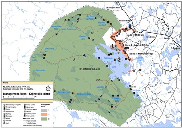
Map 5: Kejimkujik Inland Management Areas
A detailed map of the three managed areas in Kejimkujik Inland.
Managed Area 1 includes Jeremys Bay Campground on the wooded shoreline of Kejimkujik Lake. It includes the Jim Charles Point area, with its day-use beach, group campground and alternative accommodation facilities.
Managed Area 2 includes the New Connector Trail – The Ukme’k Trail which is a series of short loops reached by vehicle from the Main Parkway. It follows the meandering Mersey River and includes Mill Falls, Jakes Landing and Merrymakedge.
Managed Area 3 includes the backcountry. It consists of the majority of the Zone II area of the park, extending to the west and south of Kejimkujik Lake.
It also includes a detailed map of Kejimkujik inland facilities with icons marking each location for each of the facilities. These include:
Backcountry Campsites
Group Camping
Cabins
Patrol Cabins
Parking Areas
Fire towers
Kiosks
Otentiks
Yurts
Visitor Centre
Picnic Areas
Viewing and Look-off areas
Helipad
Viewing Tower
Boat Launch
Paved Roads
Unpaved Roads
Trails and Portages
Administrative Boundary for the Park
There is also a map scale bar to assist with measuring distances.
Objectives
The feasibility of further infrastructure investments for campground facilities, such as playgrounds, additional alternative accommodations, theatre and event space, and a centralized kiosk/service hub for check-ins, firewood, ice, and other services, is explored.
Vegetation in and around the campground, in response to hemlock woolly adelgid and other impacts, is diversified in accordance with a campground vegetation diversification plan that includes strategic tree removals and regeneration efforts.
Improvements to the Jim Charles Point area are explored.
Inland MA2: New Connector Trail – The Ukme’k Trail
The trail network at Kejimkujik Inland was designed in the 1960s as a series of short loops reached by vehicle from the Main Parkway. In response to visitor feedback and tourism trends, Parks Canada has constructed an expanded and connected trail network to complement what exists. A new trail, making use of some existing trails, has been constructed, connecting all day-use areas and the campground. The new six kilometre section of the connector trail, known as the Ukme’k Trail (“twisted” in Mi’kmaq), was designed to follow the meandering Mersey River and constructed to be environmentally low-impact, low-maintenance and sustainable. With features appealing to mountain and fat bike audiences, the trail is expected to be a regional destination. This new connector trail will change how visitors can experience Kejimkujik, allowing visitors to travel the entire frontcountry by trail rather than having to drive, and improving visitor safety by removing bicycle traffic from the Main Parkway. The entire 13.5-kilometre connector trail follows the Mersey River from the Mill Falls Area all the way to Kejimkujik Lake and the Merrymakedge area. In collaboration with the Mi’kmaq of Nova Scotia and knowledge holders, the route was selected to avoid archaeological sites while allowing visitors to experience the river as a key aspect of the Mi’kmaw cultural landscape. Accessible from several points at existing day-use areas and the campground, visitors may opt to bike the trail in one direction and get a shuttle to another node. The three proposed nodes are existing day-use areas that will be revitalized and renewed to better serve as entry and exit points for this trail:
Node 1: Mill Falls
Mill Falls is a popular day-use area near the front of the park, and a gateway point for the new section of Ukme’k trail. A new pedestrian bridge has been constructed below Mill Falls to provide year round access to the Ukme’k trail. Also, the possibility is being explored of using the existing asset footprint at Mill Falls, with the existing utility service and parking area, for a new Visitor Centre. The current Visitor Centre is outdated, with parking, access and space constraints. Mill Falls would provide an ideal location to welcome visitors at an iconic and beautiful destination, and provide a gateway to the scenic short walks in the area and to the new trail system as a whole.
Objectives
Mill Falls is developed as a gateway point for the new Ukme’k trail.
The river crossing at Mill Falls is improved to support year-round access.
The potential for Mill Falls as the site for a new Visitor Centre is explored.
Node 2: Jakes Landing
Jakes Landing is a key departure point for Kejimkujik’s backcountry and also for day-use canoeing and kayaking. It has a long history of being a gateway to wilderness, even prior to the establishment of Kejimkujik as a national park and historic site. Jakes Landing is well used now, but often congested with multiple uses, including increasing picnicking and day-use activity. Being the primary location of Kejimkujik Inland’s concession business, with increased equipment rentals and guiding, means this is a very busy and active area.
Objectives
Vehicle congestion issues at Jakes Landing are addressed.
Picnicking facilities at Jakes Landing are improved.
The existing concession building at Jakes Landing is revitalized, with densification on the existing footprint.
The main trail corridor is rerouted at Jakes Landing to improve public safety and wayfinding, and to address congestion.
Node 3: Merrymakedge
Merrymakedge is a key location for experiencing the Mi’kmaw cultural landscape with the rich cultural resources in the area including the monument, petroglyphs, encampment site and program areas. It should be noted that as they are exposed to the elements, the petroglyphs are fading; a new approach to presenting this cultural resource will need to be determined over the next 10 years in collaboration with the Mi’kmaq of Nova Scotia. Along the sunset shore of Kejimkujik Lake, it is also a vital day-use area for Kejimkujik with its main beach, food services, picnic areas, communal cooking grills, trails and playgrounds.
Objectives
The day-use offer and food services at Merrymakedge are revitalized and improved.
As a gateway for the trail system, additional services (e.g. bike rental, showers, shuttle) to support trail use at this location are explored.
Interpretation about the Mi’kmaw cultural landscape continues to connect visitors to the history and cultural significance of the area.
Access to petroglyphs is restricted through physical measures (e.g. signage), and alternative means to present them are developed, in collaboration with the Mi’kmaq.
Inland MA3: Backcountry
The backcountry of Kejimkujik offers an unparalleled wilderness experience with exclusive private sites in gentle and accessible terrain. The backcountry consists of the majority of the Zone II area of the park, extending to the west and south of Kejimkujik Lake. Backcountry is accessed by canoeists, kayakers and hikers, and contains 46 backcountry camping sites and three rustic rental cabins.
Some remote backcountry sites that have very limited use will be examined resulting in potential closures. Equivalent asset footprint could be added to areas where visitor demand is higher. Because some sites are more remote than others, firewood and other service provisions varies. Backcountry services and rates need to better match user demand and preference. A sectoral approach to backcountry experiences and associated services will be explored; for example, firewood provision may vary by sector, either being provided at the site, through centralized wood drops or not provided in some areas, with a fee structure that varies by sector.
The Liberty Lake hiking trail offers a challenging and rewarding perimeter route around Kejimkujik. During the life of this plan, improvements to this long distance hiking experience will be explored, including improvements to the trail route and potential of rustic shelters or cabins. Opportunities to access the south district of the park at Peskowesk Landing by shuttle only will be explored; public vehicle access will not be restored.
Objectives
Backcountry firewood services and fees better match user demand and preference.
The potential for an improved long distance hiking experience in the backcountry, potentially with rustic shelters or cabins, is explored.
Possible retirement of some little-used backcountry sites and replacement with new ones in more desirable areas is explored.
Seaside MA1: Port Joli Head – St. Catherines River Beach
An iconic Atlantic Coastal destination, Kejimkujik Seaside has ecologically important habitats and biodiversity, and offers wilderness coastal experiences with outstanding hiking. Parks Canada will continue to work with local conservation organizations to increase understanding and protection of Kejimkujik Seaside in the broader coastal and marine environment and support landscape conservation efforts. Over this planning cycle, Kejimkujik will continue to work toward gazetting the federal lands on the Port Mouton side and will contemplate additional land acquisition near Kejimkujik Seaside as opportunities arise.
An expanded visitor service offer during the summer months at Kejimkujik Seaside would support greater visitor understanding, education, public safety and contribute to site protection. The visitor offer at Kejimkujik Seaside will continue to focus on St. Catherines River Beach and Port Joli Head; there are no plans during the life of this plan to develop facilities at the Port Mouton side. Modest facilities concentrated at the Port Joli trail head and entrance area will complement the natural character of the overall site and the local tourism offer. A staff presence at the entrance area would provide welcoming, orientation, interpretation, way-finding, fee collection services, as well as ensure compliance with rules and public safety. Rustic accommodations may be explored for Kejimkujik Seaside; they would be located at or near the park entrance where washroom services already exist. Any development would seek to complement the local tourism offer, including Thomas Raddall Provincial Park campground and local resorts, chalets and inns. Opportunities for local tourism providers to provide visitor services at Kejimkujik (e.g. food trucks, kayak tours) will be explored.
Objectives
An increased staff presence at Kejimkujik Seaside during the summer season supports visitor safety, visitor experience, fee collection, and conservation.
The trail network at Kejimkujik Seaside is redesigned and redeveloped for sustained adaptation to climate change and storm damage.
The feasibility of rustic accommodations at Kejimkujik Seaside is explored.
Relationships between Parks Canada and local conservation organizations and local tourism providers are strengthened.
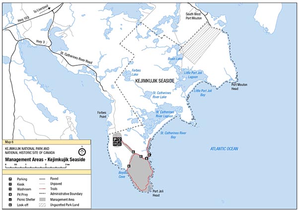
Map 6: Kejimkujik Seaside Management Areas
A detailed map of the Managed Area of Kejimkujik Seaside including Port Joli Head – St. Catherines River Beach. Kejimkujik Seaside has ecologically important habitats and biodiversity, and offers wilderness coastal experiences with outstanding hiking.
A detailed map of Kejimkujik Seaside facilities with icons marking each location for each of the facilities. These include:
Parking Kiosk
Picnic Shelter
Pit Privy
Look-off
Washrooms
Paved Road
Unpaved Road
Trails
Administrative Boundary
Ungazetted Park Land
There is also a map scale bar to assist with measuring distances.
Zoning and declared wilderness area
Zoning
Parks Canada’s national park zoning system is an integrated approach to the classification of land and water areas in a national park and designates where particular activities can occur on land or water based on the ability to support those uses. The zoning system has five categories, although not all categories must be applied:
Zone I – Special Preservation;
Zone II – Wilderness;
Zone III – Natural Environment;
Zone IV – Outdoor Recreation; and
Zone V – Park Services.
Kejimkujik’s zoning system is complex due in part to the area’s role in protecting its large concentration of species at risk (see Map 7: Kejimkujik Inland Zoning Plan and Map 8: Kejimkujik Seaside Zoning Plan). The critical habitat of several species at risk includes large areas of Kejimkujik Inland’s frontcountry, including areas immediately adjacent to existing facilities and infrastructure. For example, endangered Blanding’s turtles use infrastructure areas opportunistically, including roadsides for nesting habitat. Special management actions (such as speed bumps during nesting and hatchling seasons) are implemented to protect important ecological values during specific seasons when most required. Zoning plans are based on the best available information about natural and cultural resources and visitor experience and are modified if necessary. They are reviewed every ten years as part of the management plan review process.
Zone I – Special Preservation
Zone I areas provide an increased level of protection for the most sensitive or representative natural features and threatened cultural resources. Public motorized access (including both vehicles and motorized boat use) is not permitted. Opportunities are provided for visitors to experience and learn about these unique areas in a manner that does not threaten the value. There are 27 Zone I areas in Kejimkujik Inland and three at Kejimkujik Seaside, representing 5.8 percent and 7.7 percent of their total respective areas. These areas include (but are not limited to) critical habitat for species at risk, unique stands of old-growth forests, and sensitive Mi’kmaw petroglyphs. Additional Zone I areas for cultural resource protection may be identified in future as a result of research.
Zone I area boundaries have not been modified from the 2010 plan. However, two new Zone 1 areas have been added (numbers 26 and 27) (see Appendix 1).
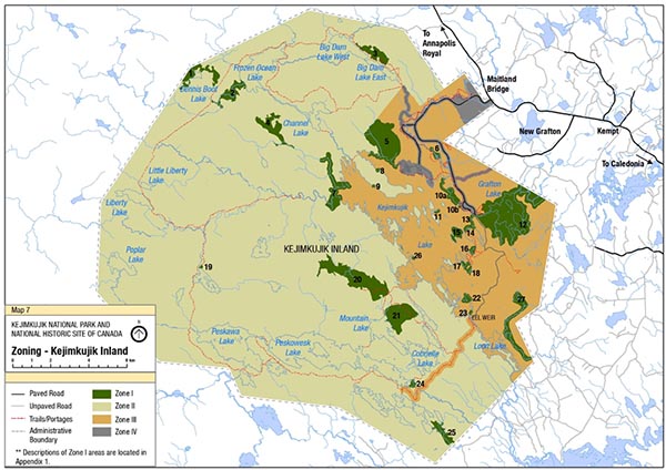
Map 7: Kejimkujik Inland Zoning
A detailed map of Kejimkujik Inland Zoning. It includes:
Zone I Areas: There are 27 Zone I areas scattered throughout the site. Public motorized access (including both vehicles and motorized boat use) is not permitted.
Zone II Areas: These are conserved in wilderness condition with minimal interference. Public motorized access (including both vehicles and motorized boat use) is not permitted. Zone II areas represent 75 percent of the total area of Kejimkujik Inland and encompass most of the area west of Kejimkujik Lake and the Mersey River, separating what is traditionally thought of as Kejimkujik’s front- and backcountry.
Zone III Areas: These areas are managed as natural areas where impacts are minimized and mitigated to the extent possible/feasible. Public motorized access is controlled.
Zone IV Areas: These include campgrounds, beach facilities, roads, and parking areas.
It also includes a detailed map of Kejimkujik inland paved and unpaved roads, trails, portages and administrative boundaries.
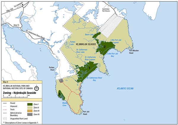
Map 8: Kejimkujik Seaside Zoning
A detailed map of Kejimkujik Seaside Zoning. It includes:
Zone 1 Areas: There are three Zone I areas on the site. Public motorized access (including both vehicles and motorized boat use) is not permitted.
Zone II Areas: These are conserved in wilderness condition with minimal interference. Public motorized access (including both vehicles and motorized boat use) is not permitted. Zone II areas represent 92 percent of the total area of Kejimkujik Seaside.
Zone III Areas: There are no Zone III areas at Kejimkujik Seaside.
Zone IV Areas: These include beach facilities, roads, and parking areas. The Zone IV area at Kejimkujik Seaside is the Port Joli entrance area.
The map also includes a detailed map of Kejimkujik Seaside paved and unpaved roads, trails, administrative boundaries and ungazetted park land.
Zone II – Wilderness
Zone II areas are conserved in wilderness condition with minimal interference. They provide high-quality backcountry opportunities for visitors to experience wilderness, including remoteness and solitude, with a high degree of visitor self-reliance and minimal built structures. Public motorized access is not permitted.
Zone II areas represent 75 percent of the total area of Kejimkujik Inland and encompass most of the area west of Kejimkujik Lake and the Mersey River, separating what is traditionally thought of as Kejimkujik’s front- and backcountry.
Most of Kejimkujik Seaside is designated as Zone II, representing 92.1 percent of the total area.
Zone III – Natural Environment
Zone III areas are managed as natural areas where impacts are minimized and mitigated to the extent possible/feasible. Zone III areas provide high quality frontcountry opportunities to experience and learn about the natural and cultural environment and are supported by minimal facilities of a rustic nature.
While public motorized access may be allowed in Zone III areas, it will be controlled, and public transportation is encouraged.
Zone III areas represent 17.5 percent of the total area of Kejimkujik Inland. There are no Zone III areas at Kejimkujik Seaside.
Zone IV – Outdoor Recreation
Zone IV areas are small areas that support intensive visitor use and infrastructure such as campgrounds, beach facilities, roads, and parking areas. Zone IV areas offer high-quality frontcountry recreational and learning opportunities with an emphasis on accessibility and safety.
Zone IV areas encompass 1.8 percent of the total area of Kejimkujik Inland and 0.2 percent of Kejimkujik Seaside. The Zone IV area at the Port Joli entrance area of Kejimkujik Seaside has been expanded to accommodate potential changes related to an exploration of rustic accommodations at the site. The remaining area of Crown land on the Port Mouton side will be added to the description of Kejimkujik in Schedule 1 of the Canada National Parks Act and will be zoned during the next management plan review process.
8.2 Wilderness Area Declaration
The intent of legally designating a portion of a national park as wilderness is to maintain its wilderness character in perpetuity. Only activities that are unlikely to impair the wilderness character of the area may be authorized within the declared wilderness area of Kejimkujik.
At Kejimkujik, although a wilderness area had been identified in the 2010 management plan for the park with the intention to declare it in regulations following the plan approval, this did not occur. A wilderness area will be considered for Kejimkujik during the next management plan review.
Summary of strategic environmental assessment
All national park management plans are assessed through a strategic environmental assessment (SEA) to understand the potential for cumulative effects. This understanding contributes to evidence-based decision-making that supports ecological integrity being maintained or restored over the life of the plan. The strategic environmental assessment for the management plan for Kejimkujik considered the potential impacts of climate change, local and regional activities around the park, expected increase in visitation and proposals within the management plan and included considerations of the potential impacts on the commemorative integrity of the national historic site. The strategic environmental assessment assessed the potential impacts on species at risk, wetlands, common loons, and cultural landscapes as well as coastal, forest and freshwater ecosystems.
Coastal ecosystems in Kejimkujik Seaside are subject to cumulative effects from invasive species, climate change, acid precipitation, increasing visitation, and external activities. The management plan identifies priorities to manage the impacts of these stressors, such as the removal of green crab within the Little Port Joli Estuary and St. Catherines River Estuary, while identifying the need to increase the resilience and adaptive capacity of the ecosystem.
While the forest ecosystem indicator is ranked as “Good” in the 2018 State of the Park Assessment, it is anticipated that up to 80 percent of Kejimkujik’s eastern hemlock trees could be lost within the life of the management plan due to the spread of the invasive hemlock woolly adelgid. To mitigate this, the management plan indicates that Parks Canada in collaboration with the Mi’kmaq of Nova Scotia will investigate control methods for this invasive species, such as chemical and biological control, within priority old growth hemlock, while also using silviculture and planting to manage the forest community structure of hemlock forests in the park.
Invasive aquatic species, such as the chain pickerel, can rapidly alter freshwater ecosystems and have recently been discovered within the boundaries of Kejimkujik Inland, while smallmouth bass also have the potential to spread into the park. The management plan identifies the importance of collaborating with regional partners to reduce the impact of chain pickerel on freshwater ecosystems while addressing the resilience of freshwater ecosystems to future cumulative effects in response to climate change and acidification. The management plan also identifies objectives to maintain or increase species at risk populations, particularly Blanding’s turtle and eastern ribbonsnake populations. These mitigations include the protection of habitat through zoning and other measures to reduce the impacts of cumulative effects on these species.
The management plan will result in many positive impacts on the environment including the maintenance and improvement of ecological integrity and commemorative integrity of Kejimkujik, stronger partnerships with the Mi’kmaq of Nova Scotia, and closer working relationships with other stakeholders to address regional conservation initiatives such as landscape connectivity to increase the resilience of ecosystems to landscape-level stressors.
The Mi’kmaq of Nova Scotia, stakeholders and the public were consulted on the draft management plan and summary of the draft strategic environmental assessment. Feedback has been considered and incorporated into the strategic environmental assessment and management plan as appropriate.
The SEA was conducted in accordance with the Cabinet Directive on the Environmental Assessment of Policy, Plan and Program Proposals (2010) and facilitated an evaluation of how the management plan contributed to the Federal Sustainable Development Strategy. Individual projects undertaken to implement management plan objectives at the site will be evaluated to determine if an impact assessment is required under theImpact Assessment Act, or successor legislation. The management plan supports the Federal Sustainable Development Strategy goals of Effective Action on Climate Change, Greening Government, Healthy Coasts and Oceans, Pristine Lakes and Rivers, Sustainably Managed Lands and Forests, Healthy Wildlife Populations and Connecting Canadians with Nature.
Many positive environmental effects are expected and there are no important negative environmental effects anticipated from implementation of the Kejimkujik National Park and National Historic Site Management Plan.
Appendix A: Zone I descriptions
Kejimkujik Inland
There are 27 Zone I areas within the inland portion of Kejimkujik:
The Eastern hemlock (Tsuga canadensis) stand near Dennis Boot Lake features some of the largest old-growth hemlock trees in Kejimkujik. Also present are areas where large hemlocks have been blown down by high winds, illustrating the effects of powerful natural forces.
The Innis Brook floodplain is a fragile area containing one of the best examples of an old-growth red maple (Acer rubrum) floodplain.
The significant stand of old-growth hemlock located along the north side of Big Dam Lake, features trees more than 300 years old.
Atkins Meadow bog (to the west of Channel Lake) features patches of curly grass fern. The bog also serves as a research site for measuring the park wetland monitoring program.
This area includes Heber Meadows, featuring important endangered Blanding’s turtle overwintering and feeding habitat. The Kejimkujik shoreline includes Blanding’s turtle nesting habitat and rare Atlantic Coastal Plain flora, including water pennywort (Hydrocotyle umbellata) habitat immediately adjacent to Meadow Beach.
The Mersey River and braided islands in this area support uncommon Atlantic Coastal Plain flora and provide important winter habitat for the endangered Blanding’s turtle.
Glode Island and nearby Glode Point are important nesting habitat for the endangered Blanding’s turtle population found in the vicinity of West River and Atkins Meadow Brook.
The deeply notched cove on the northeastern shoreline of Indian Point is excellent aquatic plant habitat and includes a large colony of threatened water pennywort.
The west side of Indian Point has both sand and cobble beaches as well as muddy flats – ideal habitat for a diversity of Atlantic Coastal Plain flora.
This area contains important Mi’kmaw cultural features, including petroglyphs and a 19th-century burial ground. The Fairy Bay shoreline area supports a rich diversity of plants, including water pennywort, threatened eastern ribbonsnake (Thamnophis sauritus septentrionalis), and other Atlantic Coastal Plain species.
Ell Island provides excellent habitat for water pennywort and a variety of uncommon Atlantic Coastal Plain flora.
Grafton Lake, the associated Minard Brook and Sweeney Brook drainage basins and the adjacent perimeter of Kejimkujik Lake combine to create an important habitat for rare flora and fauna. The open hardwood forest and edge habitats support provincially rare species such as American cancer-root (Conopholis americana), wavy-leaved aster (Symphyotrichum undulatum), panicled hawkweed (Hieracium paniculatum), large tick-trefoil (Hylodesmum glutinosum), and silvery-flowered sedge (Carex argyrantha). The area provides important habitat for endangered Blanding’s turtles, and high concentration of threatened eastern ribbonsnake. A Zone III corridor accommodates the presence of the Eel Weir Road.
The area north of Mill Bay protects Mi’kmaw petroglyphs.
The tip of Peter Point protects Mi’kmaw petroglyphs and water pennywort.
Peale Island contains a unique old growth sugar maple (Acer saccharum)/yellow birch (Betula alleghaniensis)/white ash (Fraxinus americana) stand (a rare stand type in Kejimkujik). The shoreline is habitat for threatened eastern ribbonsnake.
This area has extensive shoreline habitat for a diversity of uncommon Atlantic Coastal Plain flora and is nesting habitat for the endangered Blanding’s turtle.
The land between the base of Peter Point and Snake Lake is excellent habitat for Atlantic Coastal Plain plants.
An assemblage of rare Atlantic Coastal Plain flora occurs southeast of Snake Lake.
The stream at the north end of Big Red Lake contains the only known community of netted chain fern in Kejimkujik.
This area contains an old-growth sugar maple–yellow birch forest. It is contiguous with the bog/fen wetland area north of Mountain Lake but on a higher elevation, and is an important component of Kejimkujik’s old-growth forests.
The wetland bog/fen area between Mountain Lake and North Cranberry Lake features exceptional examples of the rare Scheuchzeria-Sphagnum association.
The small cove on George Lake contains threatened water pennywort and other Atlantic Coastal Plain flora.
The southern shore of George Lake protects Mi’kmaw petroglyphs and a small population of water pennywort.
The extreme southeast end of Peskowesk Lake contains a significant variety of rare and uncommon Atlantic Coastal Plain plant species.
Mud Lake is a shallow, acid water body in the southern portion of Kejimkujik. It is an excellent example of lake succession and features a variety of significant plant species. High concentrations of rare floating aquatic vegetation also occur within the lake.
The islands of Dark, Parmotrema and Ell include a rare lichen Parmotrema perforatum that is only known to occur at four locations in Canada. Dark Island also features an ancient stand of very old hemlock trees (greater than300 years).
This area includes the lower portion of Paddy and Cannon Brook, featuring extensive wetlands and flood plain forests. This is an important overwintering and summer feeding area for Blanding’s turtle.
Kejimkujik Seaside
There are three Zone I areas within Kejimkujik Seaside:
St. Catherines River Beach and Lagoon is primary nesting habitat for the piping plover. This area will continue to be restricted to visitors during the nesting season.
Little Port Joli Beach and Lagoon is nesting habitat for the piping plover. This area will continue to be restricted to visitors during the nesting season.
Boyds Cove contains a spectacular display of orchids and pitcher plants susceptible to trampling, including arethusa (Arethusa bulbosa) – some of which are the rare white form, tuberous grass pink (Calopogon tuberosus), club-spur orchid (Platanthera clavellata), upright common juniper, and krummholz black spruce.
Contact us
For more information about the management plan or about the Kejimkujik National Park and National Historic Site of Canada:
Kejimkujik National Park and National Historic Site of Canada P.O. Box 236
Maitland Bridge NS B0T 1B0