
Mnjikaning Fish Weirs Historic Site of Canada Management Statement
Mnjikaning Fish Weirs National Historic Site
© His Majesty the King in Right of Canada, represented by the President and Chief Executive Officer of Parks Canada, 2025.
Cette publication est aussi disponible en français.
Lieu historique national du Canada des Barrages-de-Pêche-Mnjikaning Énoncé de gestion
- Paper: 978-0-660-45112-1
- R64-599/2025E
- PDF: 978-0-660-45111-4
- R64-599/2025E-PDF
For more information on this management statement or about
Mnjikaning Fish Weirs National Historic Site of Canada
P.O. Box 567, 2155 Ashburnham Drive
Peterborough ON K9J 6Z6
Front cover image credits
Parks Canada
Approval
Approved by:
David Britton
Director
Ontario Waterways
Parks Canada manages one of the finest and most extensive systems of protected natural and historic areas in the world. The Agency’s mandate is to protect and present these places for the benefit and enjoyment of current and future generations. This management statement outlines Parks Canada’s management approach and objectives for Mnjikaning Fish Weirs National Historic Site of Canada.
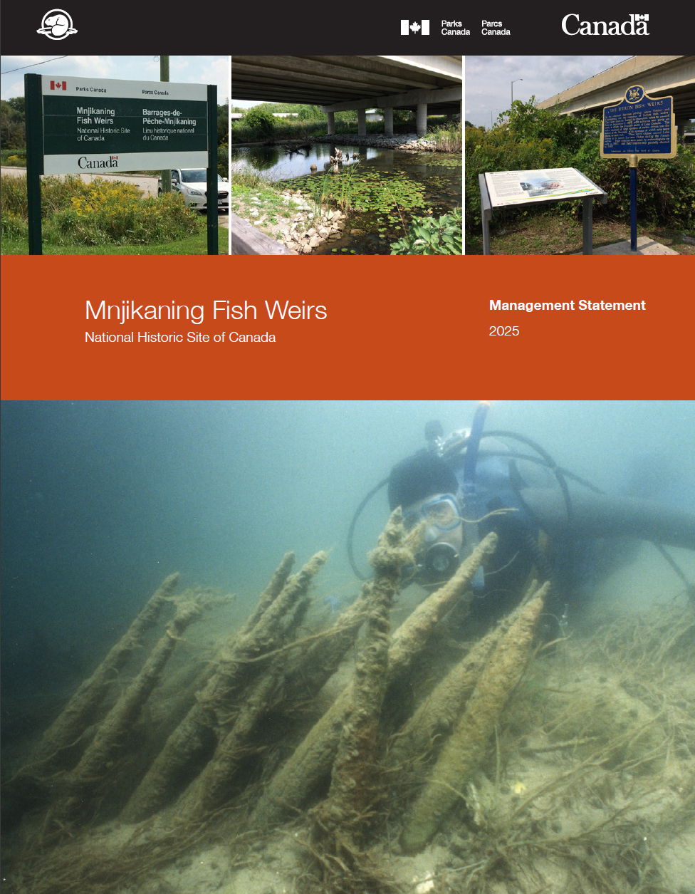
Mnjikaning Fish Weirs National Historic Site of Canada is located on portions of the bottom of the Narrows between Lakes Simcoe and Couchiching.
The Site includes the navigable marked channel, the old channel that runs to the northeast, and marshland surrounding these channels. The constriction of the Narrows allowed fish to be caught as they moved between the lakes, and the shallowness of the channel permitted wooden weirs to be built there.
The channel today is divided into two: the original channel curves to the northeast and the navigation channel runs straight to the north. The navigation channel was first dredged in 1856 to 1857, and dredging has also taken place in the original channel south of the junction. A linear island has been created along the eastern side of the navigation channel. A causeway for an old Canadian Pacific Railway bed runs across the north end of the narrows. Marshland lies in between these channels, and to the east of the old channel. A third channel appears to have existed in the past, curving to the west of the navigation channel and it has been largely filled in by modern development.
In 1982, the Mnjikaning Fish Weirs was designated a national historic site of Canada because:
- the site contains the largest and best-preserved wooden fish weirs known in eastern North America, in use from about 3300 B.C. until the recent past;
- the site was cared for and used by the Huron-Wendat First Nation in the centuries immediately before 1650 A.D., and today the Huron-Wendat and Anishinaabeg are stewards of the site; and
- For the Huron-Wendat and Anishinaabeg, this is a sacred place that represents an ancient and ongoing spiritual bond between the Creator and all living things. The spirits of people, water, animals, birds and fish are seen as all coming together in respect and gratitude at Mnjikaning.
The oldest wooden stakes are clustered in the east channel, and samples taken from the stakes have provided carbon dates in excess of 5000 years old (also know as the Little Archaic period by archaeologists). Little is known about this area in this period of time and the cultural affiliations of the earliest people who used the weirs. Another cluster of 12 radiocarbon dates falls within the time that the Huron-Wendat and their immediate ancestors lived in the area around the Narrows.
Management approached
At the northern end of the Waterway, the Mnjikaning Fish Weirs National Historic Site reflects the 5,000 year-old history of Indigenous use of these waters for fishing. However, the underwater site is exposed and vulnerable to outside perturbations such as boating activity and nearby development. Moreover, awareness of, and learning opportunities about, the significance of this sacred area is limited. Presently, many fish weir stakes are in storage in the Collection facility managed by Parks Canada in Ottawa, while other stakes are on loan to the Orillia Museum of Art, the Mnjikaning Fish Fence Circle, and the Chippewa of Rama First Nation. Further work is required to understand the condition of the fish weirs, and to inform decision-making on conservation, interpretation opportunities and ongoing monitoring.
The Mnjikaning Fish Fence Circle (MFFC) was established when the removal of stakes was proposed by Parks Canada. Many people, including members of the Chippewas of Rama First Nation, were concerned about disturbing the ancient Indigenous artifacts. Through open and respectful discussion, and using Indigenous methods to explore ideas, the group became the formal entity as the guardian of the Mnjikaning Fish Weirs.
In 1993, the Mnjikaning Fish Fence Circle oversaw the removal, by qualified underwater archaeologists, of a small number of weir stakes from the Atherley Narrows that were threatened by erosion, boat traffic and fishing pressures.
Members of the Circle include representatives of the Chippewas of Rama First Nation, local municipal governments and historical associations, and residents of the area. Since 2018, Parks Canada has been consulting with the Mnjikaning Fish Fence Circle on the development of text for a Historic Sites and Monuments Board of Canada (HSBMC) plaque. This plaque will communicate the history and significance of the site in English, French and Ojibway, with guidance from the Chippewas of Rama First Nation.
Concurrently, the Atherley Narrows Pedestrian Bridge Project, undertaken by the City of Orillia in partnership with Ramara Township and the Chippewas of Rama First Nation, proposes a recreational trail across the Atherley Narrows to address a functional gap within the Trans Canada Trail system. The preliminary concept includes a multi-use bridge crossing; an interpretive centre incorporated into the bridge abutment; and a platform at the water's edge for sacred ceremonies. Parks Canada will support this project by working with involved parties to help conserve and interpret the cultural and natural heritage resources at this location.
Management objectives
Objective: A renewed and strengthened collaboration between Parks Canada, the Mnjikaning Fish Fence Circle and the City of Orillia enhances the understanding of the condition of the fish weirs, and supports the conservation and ongoing monitoring of the site.
Objective: A renewed and strengthened collaboration between Parks Canada, the Mnjikaning Fish Fence Circle and the City of Orillia in the areas of interpretation and promotion ensures the Mnjikaning Fish Weirs is a protected and valued landmark on the Trent-Severn Waterway.
Objective: Parks Canada collaborates with the Mnjikaning Fish Fence Circle to install a HSBMC plaque at Atherley Narrows.
- Date modified :