
Other Effective Area-Based Conservation Measures
Fortress of Louisbourg National Historic Site
The Fortress of Louisbourg National Historic Site is now acknowledged as an Other Effective area-based Conservation Measure (OECM) for its biodiversity and ecological value and the current land use, governance, and management practices that contribute to that conservation. A 5,922 hectare (ha) area is now recognized as an OECM for the national historic site.
What is an OECM?
Other Effective area-based Conservation Measures are lands managed in ways that achieve the conservation of biodiversity. An OECM has similar biodiversity outcomes to parks and protected areas but they are established for different purposes. This type of recognition helps geographically define areas that support biodiversity and are managed in a way that results in its effective conservation. All national parks are reported as protected areas, whereas historic sites can now be reported as OECMs.The Fortress of Louisbourg National Historic Site supports occurrences of several federally listed species at risk including two bats – little brown myotis (Myotis lucifugus) and northern myotis (Myotis septentrionalis) – both listed as endangered under the Species at Risk Act as well as bank swallows (Riparia riparia) and barn swallows (Hirundo rustica) – both threatened. The 5,920 ha of the site being reported as an OECM is entirely in natural ecosystem cover, a mix of intact rocky coastline and headlands, coastal barrens, coniferous forest, and wetland ecosystems with a full range of native species and supporting ecological processes characteristics of the region. The national historic site is also contiguous with the Stillwaters Wilderness Area, managed by the province of Nova Scotia. Together these areas help protect the drinking water supply for the nearby town of Louisbourg.
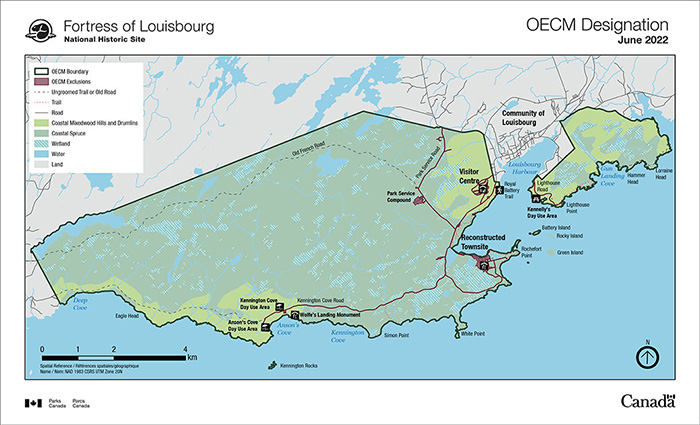
Map 1 – Fortress of Louisbourg National Historic Site Other Effective Areas of Conservation Measures (OECM) Designation 2022 — Text version.
A thematic map showing the area of Louisbourg which includes Fortress of Louisbourg National Historic Site, the community of Louisbourg, and surrounding green spaces. A black line delineates the boundaries of the newly designated Other Effective Conservation Measures areas. Two separate areas of land are delineated with black boundary lines, one southeast of the community of Louisbourg and the other, much larger, southwest. Areas that are excluded from Other Effective Areas of Conservation Measures are shaded in a burgundy colour which includes: Fortress of Louisbourg Visitor Centre, Parks Canada service compound and the reconstructed town site at Fortress of Louisbourg National Historic Site.
A legend indicates geographic characteristics of this area and are listed in the following order:
OECM Boundary
OECM Exclusions
Ungroomed Trail or Road
Trail
Road
Coastal Mixedwood Hills and Drumlins
Coastal Spruce
Wetland
Water
Land
- Date modified :