
B. History and development
- Description of property
- History and development
- Defence of the Empire
- Lieutenant-Colonel John By’s Vision
- The Changing Role of the Canal
- The Changing Role of the Canal’s Fortifications
- The Structural History of the Canal’s Engineering Works
- The Structural History of the Canal’s Bridges
- The Structural History of the Canal’s Buildings and Fortifications
- The History of the Conservation of the Rideau Canal and its Fortifications
B. History and development of the property
Upper Brewers Lockstation was the site of an 1802 mill that was destroyed by the construction of the Rideau Canal.
© Parks CanadaAs a result of the American War of Independence, thousands of people who remained loyal to the British Crown moved northwards to Canada. The influx of these loyalists led the government to examine the Cataraqui and the Rideau rivers to determine if adjacent lands were suitable for settlement. By 1800, most of the land along the two rivers had been surveyed and a number of mills had been built, the first, at Kingston Mills, in 1784. Within a few years, there were mills at most of the major falls along the two rivers: at Nicholson’s Rapids in 1785, at Merrickville in 1792, followed by Burritt’s Rapids in 1793, at Davis in 1800, and at Brewer’s Upper Mills in 1802. Despite the presence of these mills, settlement of the interior was very slow. Neither the Rideau nor the Cataraqui was easily navigable, and roads were scarce. It was, consequently, difficult to reach the St. Lawrence River, then the primary transportation route in the colony.
Defence of the Empire
The Rideau Canal was built in response to the tensions that existed between Great Britain and the United States of America, which erupted in armed conflict with the outbreak of the War of 1812. The primary theatre of the war was the colony of Upper Canada (now the Province of Ontario), and the St. Lawrence River was Britain’s only military supply line to the colony. During the war, the inadequacy of the St. Lawrence River for this purpose became increasingly apparent. Not only was travel on the river exceedingly slow and costly, because of a series of rapids, but also the river itself was exposed to American attack along most of its length between Montréal and Lake Ontario. Disruption of the supply line would have jeopardized the security of the colony. British authorities were determined to prevent such a situation from arising and developed the concept of a military canal linking the Ottawa River and Lake Ontario.
What also became evident to military planners early in the war was the need for a substantial naval force on Lake Ontario. In an era when virtually all transportation was by water, the control of Lake Ontario was essential for the defence of the colony. The British naval dockyard in Kingston was the centre for ship construction, and the War of 1812 saw a virtual arms race as each side built larger and more heavily armed ships. The need for strong defensive works in connection with the Kingston dockyard, along with a secure military supply route, was regarded as vital for the defence of the colony. Even with the end of hostilities, the United States of America was still seen as a potential threat to the security of Canada. Military planners were determined to pursue the idea of a military canal and, in the fall of 1814, turned their attention to the Rideau and Cataraqui rivers as a possible route. Twelve years later, work began on the construction of the Rideau Canal.
Lieutenant-Colonel John By’s Vision
Lieutenant-Colonel John By of the Corps of Royal Engineers was appointed by the British government to supervise the construction of the Rideau Canal, and he arrived in Canada in the spring of 1826. What he discovered, when he travelled the proposed route for the canal, was a wilderness. The land had been surveyed years earlier, but the area was only sparsely populated.
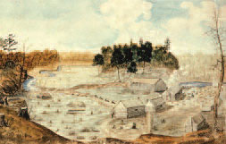
The Rideau-Cataraqui region was a virtual wilderness when the construction of the canal began.
© Parks CanadaBesides Kingston, located at the point where the Cataraqui River flows into Lake Ontario, the only established communities were the milling villages of Merrickville, Burritt’s Rapids and Chaffey’s Mills. A network of roads had been developed to provide access to Kingston and, northward, to the Ottawa River, but most of them were no more than trails. Lumbering, the chief source of income, was impeded by the difficulty of transporting the timber because of the numerous rapids of the two rivers.
Before John By’s arrival, the route for the canal had been studied in considerable detail, and an engineering approach to its construction had been recommended. This involved bypassing the rapids of the rivers with excavated channels where locks would be used to overcome elevation changes. The implementation of this plan would have entailed the excavation of more than 40 km of channels over the 202-km length of the canal. Lieutenant-Colonel By, as a result of his initial survey of the route, decided to adopt a quite different approach. In the words of historian Robert Passfield, in Building the Rideau Canal , he constructed “a slackwater system in which high dams raised the water level to flood the rapids and back up the water to a navigable depth. Each stillwater so created would stretch upriver to the base of the dam at the next set of rapids. … The construction of a slackwater system complicated the surveying task but it reduced excavation work immensely … and the depth of the excavations was also reduced considerably.”
The specifications for the Rideau Canal, as approved by the British government, called for locks 33 m long by 3 m wide and 1,5 m deep. These were the dimensions of the locks of the recently built Lachine Canal near Montréal, which were designed for flat-bottomed vessels propelled by sail or manpower. Immediately upon his arrival in 1826, John By began to press his superiors to approve much larger locks that would accommodate steamboats, just then making their appearance in North America. His reasons were both military and commercial. He argued that steamboats were faster and more versatile for moving troops and supplies, that they could be readily armed during wartime, and that they would ensure Britain’s control over Lake Ontario. Steamboats also had obvious commercial benefits for the transportation of raw materials and agricultural produce. His recommendation was for locks 40,8 m long by 10,1 m wide, with a depth of 1,5 m.
Lieutenant-Colonel By’s request for larger locks on the canal initially met with considerable scepticism. Apart from the increased costs, there was concern over the scale of the locks, which was unprecedented at the time. John By persevered, and, after two commissions had examined the benefits of a steamboat canal, the government accepted his recommendations, although the length of locks that was approved was reduced to 37,8 m. In the summer of 1828, the new estimates for the cost of the canal were accepted and construction proceeded on the larger locks.
An excerpt from Building the Rideau Canal well describes the types of design and engineering challenges that John By faced and resolved during the construction of the canal:
“Determining the best route for a canal and an efficient layout for the canal structures was one of the most demanding tasks in 19th century civil engineering. It required skill and judgment, exhaustive survey work and a minute exploration of the terrain. The object was to find not only a practicable route, but one which would best preserve the [water] level desired with an absolute minimum of excavating and embanking over the shortest possible distance. Even with the best of planning, changes were commonly made during construction, as was the case of the first [Ottawa] section of the Rideau Canal, to take full advantage of the terrain. Between the Entrance Valley and Dows Swamp two canal cuts were made, joined by a natural gully, and two parallel mounds were erected across Dows Swamp using clay from the canal excavations. The mounds were about 804 m apart and between them raised the water level to form Dows Lake. Two of the three locks intended for Hog’s Back were moved to Hartwell’s where higher ground began beyond the lake. With the canal raised 6,7 m at Hartwell’s, it was possible to follow a straight cut directly to the Hog’s Back with a minimum of excavation.”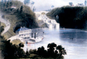
Lieutenant-Colonel John By chose “Entrance Valley” as the location for the Ottawa Lockstation.
© Parks CanadaWhen the decision was made to construct larger locks, new plans and specifications were prepared for the enlarged works, and construction was underway at all the sites by the end of 1828. The construction of the Rideau Canal was an immense and daunting project, involving more than 6 000 workers at multiple worksites. Despite unforeseen circumstances, such as higher-than-expected water volumes and unfavourable soil and rock conditions, the work progressed well. Late in 1830, Lieutenant- Colonel By predicted that navigation of the entire canal would be possible by August of 1831. His prediction proved optimistic, but it was only a few months later, on 24 May 1832, that he began a triumphant journey along the full length of the canal from the Ottawa River to Kingston.
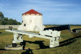
The Rideau Canal was built for military purposes, to provide a secure transportation route for British troops and supplies between Montréal and Kingston. During its construction, Lieutenant- Colonel By did not lose sight of its strategic function and included in his plans the building of a blockhouse at each lockstation. In the end, the cost was deemed prohibitive and only six were built at locations considered particularly vulnerable: Merrickville, The Narrows, Newboro, Jones Falls, Kingston Mills, and at the dam at Morton Bay.
The military planners who, following the War of 1812, had successfully recommended the building of the canal, had also foreseen the need for the construction of strong fortifications at its southern terminus at Kingston. Upon completion of the canal, work began on the most important component of the defensive system planned for Kingston, the replacement of the inadequate 1812 fortifications on Point Henry, located on the eastern side of Kingston Harbour and the entrance to the Rideau Canal.
Point Henry is an elevated promontory some 30 m above lake level, with a commanding view of the north channel of the St. Lawrence River, the entrance to the Rideau Canal, and Kingston Harbour. Work began on Fort Henry in 1832, the Royal Engineers having designed a self-defending redoubt, with an advanced battery to the south, joined to the redoubt by two ranges of commissariat stores. A branch ditch ran from the east and west sides of the redoubt to the shore. When construction was completed in 1842, Fort Henry was the largest and strongest British fortification in North America west of Quebec City. Several years later, in recognition of their defensive weakness, a small tower was built at the lower extremity of each of the branch ditches.
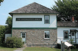
The defensible lockmaster’s house at Old Slys Lockstation was one of the many defensive structures along the canal.
© Parks CanadaWhile work was proceeding on Fort Henry, the colony of Upper Canada faced an internal crisis that led to rebellion in 1837. The rebellion was soon put down but left the authorities a legacy of uncertainty about the security of the canal. This led to the building of single-storey, stone defensible lockmaster’s houses at strategic lockstations: Old Slys, Clowes and Nicholsons. In the 1840s, in response to increasing tensions between Britain and the United States of America, more defensible lockmaster’s houses were built: at Upper and Lower Brewers, Edmonds, Hogs Back, and several other lockstations.
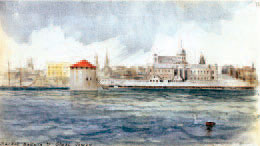
Shoal Tower is unique among Martello towers in that it is surrounded by water.
© Parks CanadaThe final steps to strengthen the defences of Kingston were also a response to the worsening relations between Britain and the United States of America. Between 1846 and 1848, the British built four Martello towers to protect Kingston Harbour and the entrance to the canal. Upon their completion in 1848, the Kingston defences, anchored by Fort Henry, provided the town, the dockyard and the Rideau Canal with substantial fortifications and ample firepower to repel attack.
The Changing Role of the Canal
Fort Henry was built to protect the entrance to the Rideau Canal at Kingston.
© Parks CanadaThe Rideau was built as a military canal and, for several decades, was an important element in the defence of Canada. It had, however, never been thought of as having an exclusively military function, and soon after it opened the canal was carrying much of the commercial traffic that had previously used the St. Lawrence River. By the middle of the century, the Rideau’s strategic importance had diminished considerably, and it had become mainly a commercial transportation system. At the same time, its role as the principal route between Montréal and Kingston also changed. In 1848, the colonial government opened a series of canals on the St. Lawrence River and enlarged the Lachine Canal at Montréal, thereby creating a much more direct route to the interior than the Rideau system. The canal, thereafter, was mainly a regional transportation system for eastern Ontario, a role it continued to serve until improvements were made in the road system after the First World War.
As a regional transportation system, the Rideau Canal was extended to the town of Perth, through what is known as the Tay Canal. Perth had been established in 1816 on the Tay River, about 13 km from Rideau Lake. Because of extensive rapids, the river was unnavigable, and, in 1830, a private company was set up to build a set of locks to provide Perth with access to the Rideau Canal. With its five small wooden locks, the canal was scarcely adequate to meet the commercial needs of Perth. In the early 1880s, local residents persuaded the federal government to build new locks, the size of those on the Rideau system. In 1887, the second Tay Canal was completed.
Perth was established in 1816. The Tay Canal, completed in 1887, gave the town’s industries access to the Rideau Canal.
© Parks CanadaAs a reliable and inexpensive means of carrying agricultural and industrial products to outside markets, the Rideau Canal had a profound impact on the development and growth of the region. In 1836, a few years after the completion of the canal, the population along the waterway stood at about 30 000. By 1861, the population had doubled, mainly between Smiths Falls and Bytown (Ottawa), where the arable land supported a prosperous agricultural population. Throughout the region, a number of small settlements expanded because of the canal. Villages such as Portland, Newboro, Westport and Chaffeys Lock thrived as small-scale milling, service or transshipment centres. Merrickville grew rapidly. By 1848, it had the largest woollen mills in the colony, and a foundry produced stoves for an expanding colonial market. Bytown, having been established as the headquarters for the construction of the canal, grew rapidly after the canal was built. In 1855, it became a city, and its name was changed to Ottawa. In 1867, it became the capital of the new Dominion of Canada.
By the end of the 19th century, the canal was
increasingly used as a recreational waterway.
© Parks CanadaA military and then a commercial transportation route, by the end of the 19th century the Rideau Canal had taken on a new role, as a vacation destination. The taste for picturesque scenery had been rising amongst the growing middle classes of Canada and the United States of America. The Rideau and Cataraqui lakes, highly valued for their scenic quality, attracted outdoor vacationers in search of fishing, scenery and camping. By the 1870s, a few vacation hotels had been established along the canal, the earliest being at Jones Falls. A number of other resorts, most notably the Opinicon Hotel at Chaffeys Lock, were established in the 1890s. Summer cottages were built in increasing numbers throughout the Rideau and Cataraqui lakes, particularly after the First World War when road access to them improved. This trend towards the recreational use of the canal accelerated rapidly during the 1950s and breathed new life into the canal.
The Changing Role of the Canal’s Fortifications
Following the tensions of the 1840s, the risk of war between Britain and the United States of America receded. As a result, there was a gradual change in the use of the fortifications built for the protection of the Rideau Canal. When British troops left the country in 1870, following the establishment of the Dominion of Canada in 1867, Fort Henry and the four Martello towers were turned over to the Department of the Militia of the Canadian government. Fort Henry continued in use as a school of artillery for the army and as a storage depot well into the 20th century. Following the Second World War, the fort became the premier tourist attraction in eastern Ontario, presenting the life of the garrison stationed there in 1867.
The Martello towers ceased any military function by the end of the 19th century. In 1925, Murney Tower was leased to the Kingston Historical Society, which still operates it as a museum.
Fort Frederick, the largest of Kingston’s Martello towers is now a museum.
© Parks Canada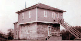
The blockhouse at Kingston Mills eventually served as a lockmaster’s house. It is now a museum.
© Parks CanadaFort Frederick became the museum of the Royal Military College of Canada. No new role was found for Shoal and Cathcart towers, because they are not easily accessible.
Although they were part of the defences of the canal, the fortified lockmaster’s houses were also intended to accommodate lockmasters and their families, a role they continued to serve until the 1960s. The Jones Falls and Morton Bay blockhouses deteriorated and were eventually demolished. The four surviving blockhouses, Newboro, The Narrows, Merrickville and Kingston Mills, were used as lockmaster’s houses and, later, as museums or lockstation offices.
The Structural History of the Canal’s Engineering Works
Summarising the structural history of the Rideau Canal, historian Robert Passfield states that:
“During the 19th century the Rideau Canal was widely acclaimed as one of the finest canals ever built. … Only a few relatively minor structural failures have occurred … over the years. Exceptionally severe flooding took place from time to time and on each occasion driftwood and ice floes borne on the crest of the flood broke through protecting booms and breached several waste weirs. None of the high stone arch dams were ever damaged, however, and only one waste weir, the Long Island weir, suffered repeated injury. The other weirs and the low overflow dams suffered only random, readily repairable damage and many of the stone weirs and overflow dams were not replaced until well into the 20th century. Most of the 47 locks have continued to function to the present day with but minor repairs or partial rebuilding and renewal of the stonework.”
The needs of the modern world have had some affect on the structures of the canal, a notable example being at Smiths Falls Combined Lockstation. As built in 1830, the 7,9 m lift required at this lockstation was the work of three locks in flight. Because of an increase in road traffic, the swing bridge over the locks was replaced in 1889 and, again, in 1923. By the 1960s, this swing bridge had become a major block to the flow of traffic. The solution proposed by the Department of Transport, responsible at that time for the operation of the canal, was the replacement of the swing bridge with a high-level fixed bridge, resulting in the construction of a new, single, electrified concrete lock. The work was completed in 1974.
An interesting sidelight to this story is the considerable opposition aroused by the plan to demolish the three original locks, and they were, in fact, preserved. A similar struggle between tradition and modern development occurred a few years earlier in connection with plans to electrify all the locks of the canal. Electrification was the Department of Transport’s response to the increased usage of the canal resulting from recreational boating. Newboro, one of the busiest locks on the system, was electrified in 1966. In the words of canal historian, Ken Watson, in A History of the Rideau Lockstations , “This met with a flurry of protest from residents and concerned groups who felt that electrifying the locks would forever compromise the historic integrity of the Rideau. Eventually, those concerned with protecting the heritage of the Rideau won out and only two other locks, the lock at Black Rapids, and the new combined lock at Smiths Falls, were ever electrified.
The Structural History of the Canal’s Bridges
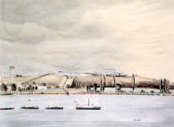
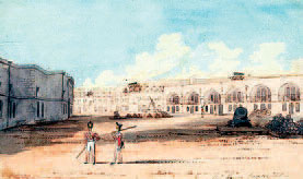
At the time of its construction, only one bridge was built to cross the
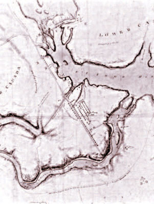
An early map of Bytown showing the Ottawa Locks and the first bridge built to cross the canal..
© Parks CanadaRideau Canal, the Sappers Bridge at the Ottawa Lockstation, connecting Upper and Lower Bytown. Eventually, swing bridges became a conspicuous feature at many of the lockstations, reflecting the development of the road system in Eastern Ontario. Watson’s story of the Merrickville Lockstation provides an interesting, if extreme, example of the evolution of bridge building on the canal in response to the needs of road traffic:
“Over the years several bridges have spanned the canal works and river. The original bridge crossing the locks was a rolling bridge, positioned over the lower end of the upper lock. It was replaced in 1843 by a timber swing bridge. In 1892, the swing bridge was replaced with a new steel bridge, this time located just downstream of the lower gates of the upper lock. This new position allowed more vessels to pass underneath it without having to swing the bridge (and disrupt traffic). It was replaced in 1933 by another steel bridge which was electrified in 1955. The current electric swing bridge was installed in 1990.”
The 1892 steel swing bridge at Merrickville. It was replaced in 1933.
© Parks CanadaThe frequency of bridge replacement at Merrickville was not typical of all lockstations. When the first road was built across Old Slys Lockstation in 1857, it crossed the waste weir by means of a fixed bridge, with a swing bridge across the lock. These two bridges were replaced only in the 1960s. Although the swing bridges in use today are all replacements of the originals, some of the steel bridges date from the late 19 th and early 20th centuries. The timber bridges found at several of the lockstations are authentically designed replacements of the originals.
The Structural History of the Canal’s Buildings and Fortifications
During the history of the canal, additional buildings, most of them lockstation offices, were added at a number of the lockstations. The lockstation office at Davis dates from 1875, that at Ottawa, from 1884, that at Edmonds, from 1905. In the 1960s and 1970s, no fewer than ten offices were built.
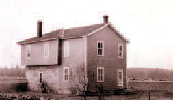
Frame second stories were added to many of the defensible lockmaster’s houses when they were no longer needed to protect the canal.
© Parks CanadaOnce they were no longer needed for defensive purposes, the canal’s blockhouses were adapted to serve other purposes. Eventually, the two that were built entirely of timber (Jones Falls and Morton Bay) deteriorated and were demolished. In the 1960s, the others, at Merrickville, The Narrows, Newboro and Kingston Mills were restored to their original 1830s appearance.
Defensible lockmaster’s houses to accommodate lockmasters and their families were built at most of the lockstations during or shortly after the construction of the canal. There was a standard pattern that most of them followed: they were small, square, one-storey stone buildings, functional but providing few physical comforts to the occupants. Towards the end of the 19th century and early in the 20th century, considerable effort was made by canal authorities to improve the living conditions of these houses by adding second storeys or building extensions to them. In a few instances, as at Kingston Mills in 1904 and at Hogs Back in 1907, the original buildings were replaced.
Fort Henry is largely unchanged since its completion in the 1840s.
© Parks CanadaSince their completion in the 1840s, there has been little structural change to the various elements of the fortifications in Kingston. Fort Henry is, today, very much as it was when construction was completed. Soon after the Martello towers were finished, the Royal Engineers, recognizing the inadvisability of leaving their flat gun platforms exposed to Canadian winters, designed easily removable roofs to protect them. The roofs have been replaced over time, but their design elements have remained consistent.
Externally, all of the Martello towers have survived intact. On the interior, however, the two towers that military authorities largely abandoned because of their inconvenient locations (Shoal and Cathcart), deteriorated badly. The wooden main floors of both towers collapsed, damaging the partition walls of the storerooms and powder magazine on the lower level of each. Otherwise, they remain structurally unchanged.
The History of the Conservation of the Rideau Canal and its Fortifications
For nearly 175 years, the Rideau Canal has continued to serve, without interruption, as a water route between Ottawa and Kingston. This is, in part, a tribute to the high construction standards that John By insisted upon during its building and, in part, to the fact that it has been well maintained over the years.
For more than two decades after its completion, the maintenance of the canal was the responsibility of the British government and, specifically, of the troops stationed at Bytown, many of whom had been involved in its construction. In 1856, the canal was turned over to the colonial government, which became responsible for its operation and maintenance. With the establishment of the Dominion of Canada in 1867, the federal government took charge of all the canals in the new country, a responsibility that it continues to have today.
For much of the canal’s history, maintenance followed the accepted practices of the day. In the early 20th century, if dams required major repairs or replacement, the work was done in concrete. Similarly with locks: damaged masonry was normally replaced in kind, but concrete was, on occasion, used instead. In addition, over time, the original wooden floors used at many of the locks were replaced by concrete, a more practical medium for the purpose.
Although maintenance practices current at the time were applied to the canal, it generally escaped the attention of modernizers anxious to update its operation. Since early in the 20th century, the growth and prosperity of the Rideau area has depended on road and railway transportation, not on the Rideau Canal. With the canal’s new focus as a recreational waterway, there has been only sporadic interest in modernizing its operation.
Another part of the history of the conservation of the canal was a growing public awareness of its historic significance. In 1926, the Historic Sites and Monuments Board of Canada recognized the canal as a national historic site, a designation that led to a closer public scrutiny of initiatives to alter its character in the name of progress. The designation also had beneficial repercussions on the treatment of significant canal buildings. Ken Watson, in his History of the Rideau Lockstations , records the story of the 1833 blockhouse at Newboro Lockstation:
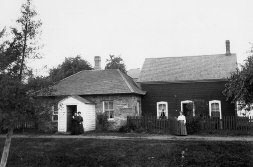
The blockhouse at The Narrows was considerably enlarged later in the 19th century.
© Parks Canada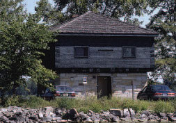
The blockhouse at The Narrows was restored
in the 1960s.
© Parks Canada“By 1856 the blockhouse was serving exclusively as the lockmaster’s house. In 1888 it underwent extensive renovations. Large framed additions were added to it, giving it the appearance of a farmhouse. … It stayed like that, deteriorating over the years, until abandoned in 1962. The Department of Transport planned to sell off or demolish the building, however the Historic Sites Branch of the federal government argued that it should be preserved. … In 1967 and 1968 the blockhouse underwent extensive renovations.” Afterwards, the department proceeded to restore the blockhouses at Merrickville, Kingston Mills and The Narrows, and the lockmaster’s house at Jones Falls.
1972 was a significant date in the history of the conservation of the Rideau Canal. In recognition of its heritage character and status as a national historic site, responsibility for the canal’s operation was transferred from the Department of Transport to the Parks Canada Agency, the federal government agency responsible for managing Canada’s national historic sites. The consequence of the transfer has been a new focus on the heritage values of the property and their protection, consistent with the agency’s Cultural Resource Management Policy .
Under the administration of the Parks Canada Agency, significant investments have been made in the stabilization and conservation of lock structures, the structural stability of dams and the periodic replacement of lock gates. As a result, since 1990 the overall asset condition has been at a relatively high level. But, despite the application of rigorous cultural resource management policies, there has been some loss of historic material due the level of structural deterioration. The westerly lock wall at Lower Brewers lock failed and collapsed in 1976 and had to be rebuilt, with as much material as possible being salvaged. At Davis and Ottawa lockstations, deterioration had advanced to the extent that several lock chambers were reconstructed. Today, techniques developed in the 1990s, allow canal engineers to stabilize the walls without dismantling the structure, thereby preventing loss of historic materials. Moreover, the ongoing monitoring of assets allows for the priorization of timely interventions consistent with principles of conservation, governing policies and best practices.
Throughout most of their history, Fort Henry and the four Martello towers were the responsibility of the Department of National Defence. Fort Henry was transferred from National Defence to the Parks Canada Agency in 1999. Three of the towers (Shoal, Murney and Cathcart) have been under the administration of the Parks Canada Agency for many years. Fort Frederick, on the grounds of the Royal Military College of Canada, continues to be under the care of National Defence.
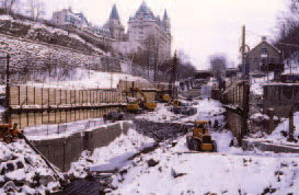
© Parks CanadaFive of the eight locks in flight at the Ottawa
Lockstation were reconstructed in the 1980s.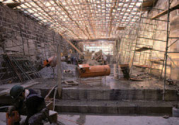
© Parks CanadaIn the late 1930s, Fort Henry, nearly a century after its completion, was subject to a major conservation project to prepare it for its new role as a tourist attraction. In the years following that conservation project, National Defence and the operator of the fort, the St. Lawrence Parks Commission, undertook a program of routine maintenance to conserve the fort’s historic fabric. Currently, Fort Henry is the subject of a second major conservation project, multi-year in scope, to address structural problems that have arisen since the 1930s.
Fort Frederick and Murney Tower, benefiting from their long-time use as museums, have never required extensive conservation work. Good routine maintenance practices in combination with careful monitoring programs and periodic structural conservation have limited the need for large-scale repairs to the two towers. The story is somewhat different for Shoal and Cathcart towers. Extensive monitoring of the two towers in the 1990s revealed significant structural problems. Major work was undertaken at Shoal Tower in the mid-1990s. Structurally, it is now quite sound. Design specifications for Cathcart have been prepared but not yet implemented.
- Date modified :