
Just below the surface
Lake Superior National Marine Conservation Area
By Aidan Fehr
Lake Superior’s history can be hard to find as some of it lies just below the surface. A Heritage Presenter from Lake Superior National Marine Conservation Area dove into the Hudson's Bay Company Archives to uncover a piece of Lake Superior's past and make the connection to the present.
One of the great things about working as a Heritage Presenter at Lake Superior National Marine Conservation Area is the opportunity to learn about Canada’s natural and cultural heritage, and to share these discoveries with others.
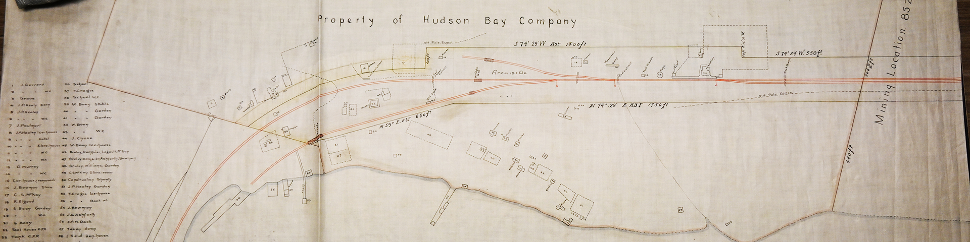
Last spring, while researching old maps for an interpretive program, I noticed the words “H.B. Post” on an old map of Lake Superior. “H.B.” is short for “Hudson’s Bay,” one of the main fur trading companies in Canada in the 1800s. The location on the map with the marker is now occupied by the village of Rossport, at the eastern end of Nipigon Bay.
In August, I had the opportunity to join our Cultural Resource Management Advisor on some field work in Rossport. We explored the western end of the harbour with an underwater remotely operated vehicle (ROV). Based on local knowledge and an old photo, we expected to find the remains of an old railway bridge. But would that be all we would find? Using the ROV, we found the remains of pilings and many railroad and shipping-related artifacts including rails, barrels, a boat propeller, and coal. How did all these pieces fit together?
I remembered that “H.B. post” from the map, so I did some research. I discovered the Hudson’s Bay Company Archive, which houses a collection of journals, maps, letters, and other documents about the Company’s history. However, the archive is located in Winnipeg – more than a stone’s throw from Parks Canada’s office in Nipigon! Luckily, I had plans to visit Winnipeg in October. I sent an email to the archive, and with the help of an archivist I made an appointment to view old maps of Rossport.
I arrived at the archive on a crisp morning and joined the archivist, who showed me to the map room. There, a wonderful assortment of maps ranging from 1884 to 1930 awaited me; showing Rossport in different stages of development, including the construction of the Canadian Pacific Railway (C.P.R.) in the 1880s and the Trans-Canada Highway in the 1930s. Best of all, I found a map of Rossport Harbour (circa 1896-1908) with each structure numbered and labelled. At the west end of Rossport Harbour lay a dock, labelled “C.P.R. Dock.” It was in the exact location we searched with the ROV and found all those railway and shipping relics. The dock was connected to Rossport Station by a short rail line. I took photos of the map, thanked the archivist, and continued my journey back to Nipigon, feeling a sense of achievement at having confirmed my suspicions about this piece of Lake Superior’s history.
Want to learn more about historic maps of Lake Superior? Discover a story of mapping mishaps and cartographic conundrums in the program “The Phantom Islands of Lake Superior,” available periodically throughout the summer at Lake Superior National Marine Conservation Area.
Back to shoreLINES
- Date modified :