
Western Weeneebeg (James Bay) and southwestern Washaybeyoh (Hudson Bay): proposed national marine conservation area (NMCA)
Description
The proposed national marine conservation area (NMCA) in Western Weeneebeg (James Bay) and southwestern Washaybeyoh (Hudson Bay) is offshore northern Ontario and Treaty 9. The Omushkego have been the stewards of these lands, waters and ice since time immemorial. It is an immensely biodiverse area with populations of beluga whales, caribou, polar bears, and is an essential global stopover for migratory birds.
Enhancing the protection of these ecosystems would not only help to conserve biodiversity and assist with addressing climate change, but would also help maintain the culture, traditions, and well-being of Omushkego communities.
This proposed NMCA contributes to two representative regions in Parks Canada’s Marine System Plan: the James Bay Marine Region and the Hudson Bay Marine Region.
If established, the proposed NMCA would:
- recognize and support Omushkego stewardship and leadership in conservation
- contribute to the long-term economic, social, and cultural well-being of Omushkego and coastal communities
- protect and conserve marine ecosystems, biodiversity, and support sustainability
- connect people to places in Canada and create enjoyable experiences for visitors
- promote awareness and understanding among Canadians
Partners
In 2021, the Government of Canada and Mushkegowuk Council (representing nine First Nations) signed a Memorandum of Understanding (MOU) to assess the feasibility of establishing an NMCA in western Weeneebeg and southwestern Washaybeyoh. A Steering committee guided the feasibility assessment process and provided recommendations to respective parties on feasibility and potential terms and conditions.
Since the conclusion of the feasibility assessment, Parks Canada continues to work with Mushkegowuk Council and the individual coastal First Nations.
Current stage
The establishment of a new NMCA generally follows a 5 step process. However, the establishment process for each NMCA is as unique as its features and considerations. As such, there is no specific timeframe for moving through the process.
In February 2024, the steering committee concluded that the establishment of an NMCA is feasible in federal waters.
The next stage is to plan and negotiate the establishment of the site. To do so, a new committee is being struck that includes direct representation of coastal First Nations as well as the Mushkegowuk Council. Consultation and engagement with First Nations and other stakeholders are actively ongoing with the goal of securing informed consent from First Nations.
-
Completed1 Identify representative marine areas
-
Completed2 Select a candidate NMCA
-
Completed3 Assess feasibility of an NMCA
-
Current step4 Negotiate establishment agreement(s)
-
5 Designate and protect NMCA in legislation
The steering committee has proposed a phased approach for the establishment of the NMCA.
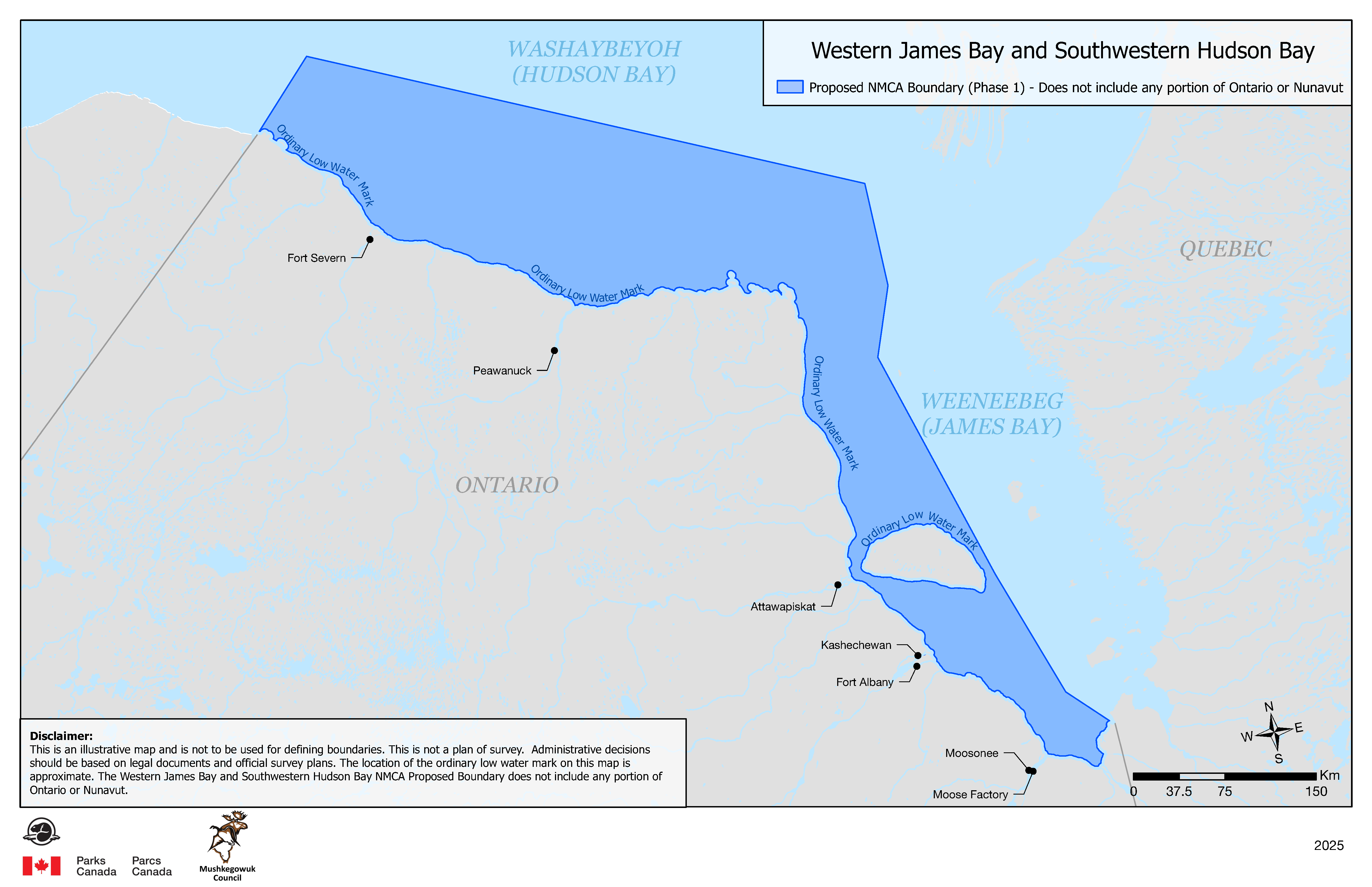
The first phase would be an 86,000 km2 proposed NMCA in offshore waters only (see map below). It does not include any portion of Ontario or Nunavut.
A potential second phase would seek the additional protection of the intertidal zones, islands, bays, estuaries, river portions, and approximately 20 km inland from the coast. This would require full engagement and support by the governments of Ontario and Nunavut. Efforts will continue to ensure the Omushkego vision is reflected and implemented.
Proposed boundary
The proposed phase 1 boundary covers approximately 86,000 km2.
Map: Proposed national marine conservation area
The dark blue section of the map represents the proposed boundary being considered (phase 1). It is not the final boundary. The recommended boundary would only be decided after consultations with all partners and rights holders are completed.
Long description
This map identifies the Western Weeneebeg (James Bay) and southwestern Washabeyoh (Hudson Bay) NMCA proposed boundaries.
The area along the coast starts at the ordinary low water mark. It begins approximately 78km to the northeast of Moosonee, extending northwest through James Bay towards Hudson Bay. The western boundary begins approximately 128km West of Fort Severn and extends approximately 73km North into Hudson Bay. The northern boundary is approximately 150km north of Ontario’s coastline.
The provinces of Ontario and Quebec are identified. The communities of Fort Severn, Peawanuk, Attawapiskat, Kashechewan, Fort Albany, Moosonee and Moose Factory are located along the coastline of Ontario.
The scale of the map is located at the bottom right and ranges from 0 KM to 150 KM.
Disclaimer located at the bottom left of the map indicates:
This is an illustrative map and is not used for defining boundaries. This is not a plan of survey. Administrative decisions should be based on legal documents and official survey plans. The location of the ordinary low water mark on this map is approximate. The Western James Bay and Southwestern Hudson Bay NMCA Proposed Boundary does not include any portion of Ontario and Nunavut.
Indigenous inherent and Treaty rights in an NMCA
Inherent Indigenous and Treaty rights would not be altered by the establishment of an NMCA. As such, Omushkego existing rights to harvest, hunt, fish, and trap would remain.
NMCA establishment and management also supports Canada’s commitment to advancing reconciliation and the implementation of rights, treaty obligations, and related commitments in a manner that reflects the spirit and intent of the United Nations Declaration on the Rights of Indigenous Peoples.
Since March 2023, Omushkego rights holders have been sharing their perspectives through community engagement sessions, on the future they wish for their homelands. Some of the key points heard by Parks Canada include:
- Omushkego would need to be directly involved in all aspects of the NMCA. Anything about the land and waters must involve local people
- The NMCA should contribute to the ongoing preservation of a thriving Omushkego identity, including language and relationship to land (including harvesting and spirituality)
- There is desire for all ages to learn about NMCAs and be involved at all stages, especially elders and youth, to envision how it could benefit Omushkego
- A guardians program could ensure Omushkego continue to have a direct role in natural and cultural protection
Activities in an NMCA
The Government of Canada is committed to achieving reconciliation with Indigenous Peoples through a renewed, nation-to-nation, and government-to-government relationship based on recognition of rights, respect, co-operation, and partnership as the foundation for transformative change. Parks Canada and Indigenous governing bodies co-develop collaborative governance models to ensure long term stewardship and ecological sustainability of these sites.
While federal departments such as Fisheries Canada, the Canadian Coast Guard and Transport Canada, retain their responsibilities inside the boundaries of an NMCA, efforts are made to ensure all authorities and stakeholders operate within the vision of the NMCA.
Activities not allowed
Generally, the following activities are not allowed in NMCAs:
- mining and oil and gas exploration, development, and production
- using bottom-trawl gear
- disposal at sea of waste and other matter, dumping of fill
- depositing drugs and pesticides
The scope of each of these activities including exceptions to their application are described in the Protection Standard for Federal Marine Protected Areas.
Timeline and next steps
Parks Canada will continue working with the coastal First Nations as well as the Mushkegowuk Council on the next steps towards the potential establishment of the site. Engagement and consultation will continue with Indigenous and local communities, other relevant jurisdictions and federal departments, stakeholders, and the public.
Contact us
Parks Canada project team
Email: wjbnmca-bjoamnc@pc.gc.ca
Related links
- Date modified :