
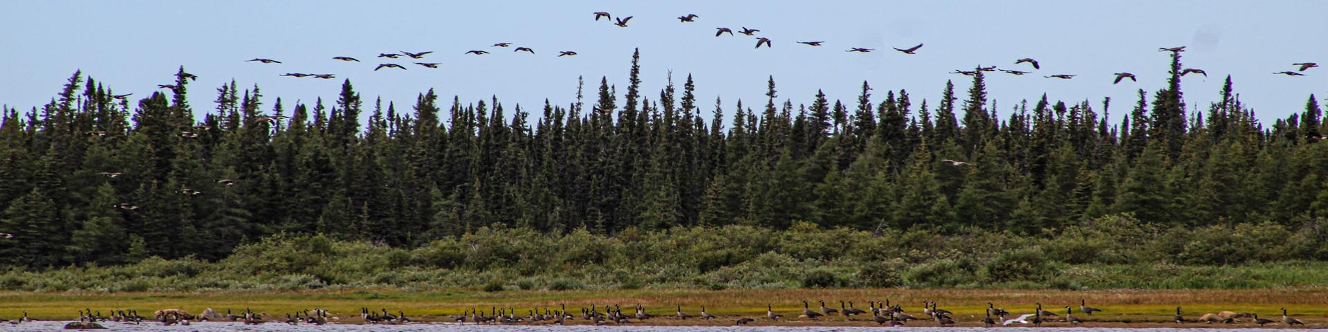
Canada geese flying over river and forest shoreline in Eeyou Istchee, Eastern James Bay.
© All rights reserved by Cree Nation Government.
Wiinipaakw: proposed Indigenous protected area and national marine conservation area (IPA-NMCA) in Eastern James Bay
Project description
The proposed Wiinipaakw (James Bay) Indigenous Protected Area and National Marine Conservation Area is located in the Eeyou Marine Region. It is in the offshore areas of Eastern James Bay, aligned from the mouth of Chisasibi-Big River south to the Québec-Ontario border. This area would support the Cree Nation Government in their marine conservation strategy. It would also contribute up to 0.45% of Canada's commitment to protecting biodiversity and conserving 30 percent of its marine waters by 2030.
The Eeyou Marine Region is rich in biodiversity, history and is essential to Cree culture and Eeyou pimaatisiiwin (the Cree way of life). Many rivers flow out into Wiinipaakw (James Bay) bringing large amounts of freshwater to the Bay. This creates a special marine environment with a salt concentration much lower than that of Chiwiinipaakw (Hudson Bay) and of oceans.
As a part of the larger Chiwiinipaakw (Hudson Bay) inland sea, Wiinipaakw (James Bay) is also a hub for migrating geese, ducks, shore birds, and marine mammals.
If established, the proposed IPA-NMCA in offshore waters would:
- be protected as an Indigenous Protected Area (IPA) through mechanisms determined by the Cree and as a National Marine Conservation Area under the Canada National Marine Conservation Area Act and Chapter 6 of the Eeyou Marine Region Land Claims Agreement (EMRLCA)
- recognize and support Cree stewardship and leadership in conservation under a dual designation as an Indigenous Protected Area and National Marine Conservation Area
- contribute to the long-term economic, social, and cultural well-being of the Crees and coastal communities
- protect and conserve marine ecosystems, biodiversity, and sustainability
- contribute to representing the James Bay Marine Region in Parks Canada’s Marine System Plan
- contribute to the continuation of pimaatisiiwin, the Cree way of life, and culture
- promote awareness and understanding of Cree culture among Canadians
Learn more about Cree Nation Government protected areas and marine conservation.
Partners
In October 2024, the Cree Nation Government and Parks Canada successfully completed a Feasibility Assessment and signed a Memorandum of Understanding (MOU) to formally work toward establishing an offshore Indigenous Protected Area and National Marine Conservation Area in the Eeyou Marine Region.
Current project stage
The establishment of a new NMCA generally follows a 5-step process. The establishment process for each NMCA is as unique as its features and considerations. There is no specific timeframe for moving through the process.
This project completed feasibility assessment and partners are currently engaged in constructive discussions. The Cree Nation Government and Parks Canada, together, intend to consider and develop the details of an establishment agreement.
-
Completed1 Identify representative marine areas
-
Completed2 Select a candidate NMCA
-
Completed3 Assess feasibility of an NMCA
-
Current step4 Negotiate establishment agreement(s)
-
5 Designate and protect NMCA in legislation
Steering committee
A steering committee was formed during the feasibility assessment, consisting of 2 Cree Nation Government representatives and 2 Parks Canada representatives.
The steering committee guided the feasibility assessment process and provided recommendations to respective parties on feasibility and potential terms and conditions.
Equitable attention was given to Cree knowledge of the area. Cree perspectives were sought and incorporated, existing scientific information gathered, and key rights holders and stakeholders engaged. Engagement and consultation will continue in the process towards establishment.
Indigenous inherent and Treaty rights in an NMCA
The Cree’s Inherent and Treaty rights to harvesting, hunting, fishing, and trapping will be protected in all aspects of an NMCA in the spirit and intent of the United Nations Declaration on the Rights of Indigenous Peoples.
It is important to note that the feasibility assessment is not intended to define, create, recognize, deny, or amend any of the rights of the Parties including Aboriginal title or rights, or treaty rights, within the meaning of sections 25 and 35 of the Constitution Act, 1982, and the Eeyou Marine Region Land Claims Agreement (EMRLCA).
Proposed boundaries
The proposed boundaries include an area of approximately 26,000 km2 in the offshore waters of eastern James Bay in the Eeyou Marine Region.
The proposed boundaries are not the final boundaries. The Cree Nation Government and Parks Canada will continue discussions to finalize proposed boundaries. Engagement, consultation and constructive discussions will continue with Indigenous and local communities, other relevant jurisdictions and federal departments, stakeholders, and the public during the next stages toward establishment.
Long description
A map legend titled Eastern James Bay is located on the top left and includes four elements:
Study Area for the proposed Wiinipaakw Indigenous Protected Area and National Marine Conservation Area (represented by a black dotted line). Terrestrial Protected and Conserved Areas (shown in green), Communities (represented by a black dot) and Eeyou Marine Region (represented by a blue line).
The proposed Wiinipaakw (James Bay) Indigenous Protected Area and national marine conservation area (IPA-NMCA) is located in the Cree Zone of the Eeyou Marine Region, in the offshore area of eastern James Bay. The northern extent of the proposed boundary aligns with the mouth of Chisasibi-Big River (not mentioned on the map), near Chisasibi, and extends northwest into the offshore waters. It then extends southwards towards the Québec-Ontario border. The Cree communities of Waskaganish, Eastmain, Wemindij and Chisasibi are located along the coastline of the province of Quebec, to the east of the proposed offshore boundary. The Cree communities' names were translated in Cree syllabics.
The proposed boundaries are adjacent to, but not located in Quebec. It would not include any portion under the administration of the Government of Nunavut. It would also not include any area of the Cree/Inuit Overlap located north of the proposed boundary. 13 unnamed terrestrial protected and conserved areas, shown in green on the map, are part of the Cree Conservation Strategy.
A disclaimer was added at the left bottom of the map and mentions the following elements:
This is an illustrative map and is not to be used for defining boundaries. This is not a plan of survey. Administrative decisions should be based on legal documents and official survey plans. A proposed Indigenous Protected Area - National Marine Conservation Area in the Eeyou Marine Region would be adjacent to but not in Québec and would not include any portion under the administration of the Government of Nunavut.
For more information on this map, contact the project team
Activities in an NMCA
There is a desire from both the Cree Nation Government and Parks Canada to develop a governance framework for the proposed IPA-NMCA that is Indigenous-led and based on the willingness to work together in the spirit of cooperation, transparency and ongoing dialogue.
NMCA management is shaped through collaboration and engagement that bring together a diversity of knowledge, perspectives, and active participation to achieve 8 interconnected goals.
As part of the management planning process, NMCAs are divided into zones. The NMCA zoning framework includes different types of zones ranging from full protection areas that prohibit recreational use and access, to areas for ecologically sustainable uses, including commercial and recreational fishing. Indigenous traditional use can continue in all zones.
In NMCAs, Fisheries and Oceans Canada maintain responsibility for fisheries management and aquaculture, and Transport Canada and the Canadian Coast Guard maintain responsibility for marine navigation and safety.
Activities not allowed
The Canada National Marine Conservation Areas Act prohibits:
- oil, gas and mineral exploitation
- aggregate exploration and exploitation
- and places strict limits on ocean disposal
The federal Marine Protected Areas Protection Standard also applies in new NMCAs and provides additional restrictions on ocean dumping and bottom trawl fishing gear, and on use of drugs and pesticides.
Timeline and next steps
The Minister and the Grand Chief/Chairperson of the Grand Council of the Crees (Eeyou Istchee)/Cree Nation Government both determined that the proposed Wiinipaakw Indigenous Protected Area and National Marine Conservation Area is feasible.
The two parties will enter into the negotiation of a Protected Areas and Impact Benefit Agreement (PAIBA) as indicated in Chapter 6 of the Eeyou Marine Region Land Claims Agreement. This will form the establishment agreement.
Engagement and consultation and constructive discussions will continue with Indigenous and local communities, other relevant jurisdictions and federal departments, stakeholders, and the public during the next stages toward establishment.
Moreover, a separate but complementary initiative to the proposed IPA-NMCA involves the collaboration between the Cree Nation Government, the Government of Québec and Parks Canada to develop a marine protected area in coastal waters adjacent to the Wiinipaakw proposed IPA-NMCA to ensure protected area connectivity throughout Eeyou Istchee.
Contact us
Parks Canada project team
Email: ebjamnc-ejbnmca@pc.gc.ca
Related links
- Date modified :