
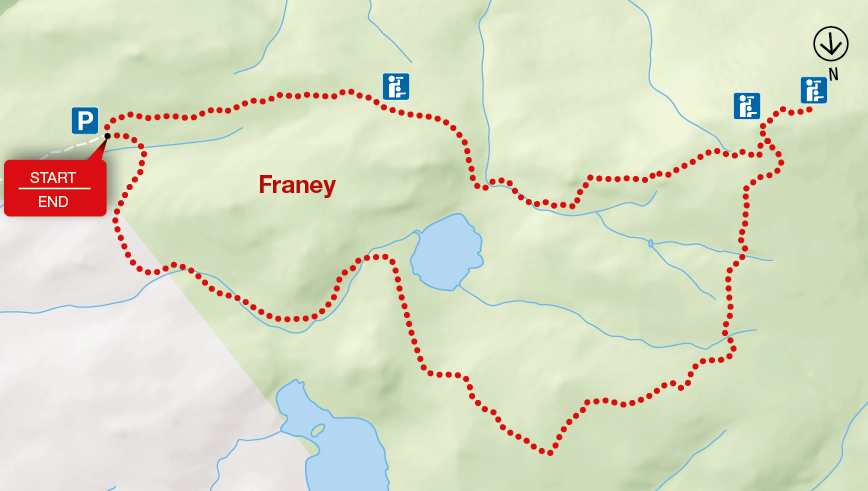
Franey
Cape Breton Highlands National Park
Note:
Plan ahead
Popular hiking trails, including Skyline and Franey, see many visitors during the summer and fall months and trail parking lots fill up fast. Be #ParkSmart and plan ahead!
- Trails are busiest between 11:00 a.m. and 4:00 p.m.
- Have a back-up plan in case the parking lot is full.
Keep it wild, keep it safe
Do you know what to do if you encounter wildlife in the park? Before your next visit, familiarize yourself with moose, bear and coyote safety familiarize yourself with moose, bear and coyote safety. Be respectful and act responsibly.
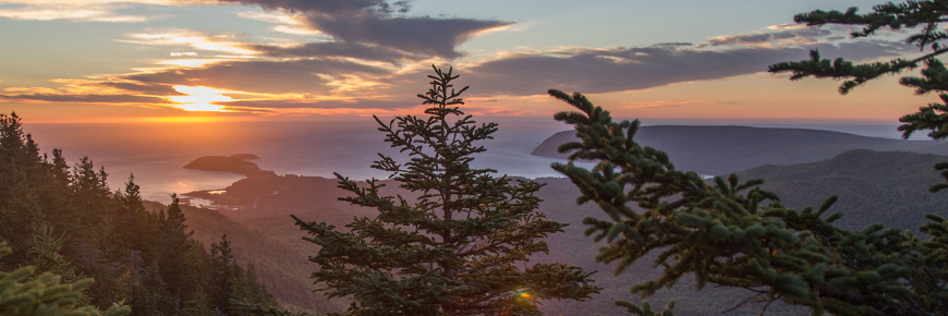
You climb up and up and your reward is at the top! Large flat rocks give you a nice place to sit and enjoy the 360º views of the entire Clyburn Brook canyon and the Atlantic coastline from Cape Smokey to Ingonish. Gaze back at the mountains, the sheer rocky face of Franey Mountain, or the river winding through the valley, 425 m below. Keep an eye out for wildlife – moose like this habitat too.
| Length | 7.4 km / 4.6 mi (loop) |
   |
| Rating | Difficult  |
|
| Elevation | 95 - 430 m (310 - 1,410 ft) | |
| Time | 2 - 3 hours | |
| Significant features | Transition from Acadian to boreal forest, mountain and ocean vistas Steep climb. Rugged sections. Caution: Keep young children away from the steep cliffs. |
|
| Trailhead | Turn off the Cabot Trail just north of the Clyburn River and follow the fire access road for about a kilometre to a small parking lot. Lat: 46.660766 Long: -60.422683 |
Related links
- Acadian
- Salmon Pools
- Le Chemin du Buttereau
- Le Buttereau
- Le vieux chemin du Cap-Rouge
- Corney Brook
- Skyline
- Bog
- Benjie's Lake
- Fishing Cove
- MacIntosh Brook
- Lone Shieling
- Aspy
- Mica Hill
- Jack Pine
- Coastal
- Jigging Cove Lake
- Green Cove
- Broad Cove Mountain
- Warren Lake
- Branch Pond Look-off
- Clyburn Valley
- Middle Head
- Freshwater Lake Look-off
- Freshwater Lake
- Date modified :