
Short hikes and walks
Yoho National Park
In Yoho National Park, you do not have to go very far from your car to find breathtaking views. Whether you are new to hiking or short on time, there are short hikes and interpretive walks to enjoy. Choose the trail that is right for you. Find maps, trail descriptions and safety information.
For maps, detailed route finding and trail descriptions, visit the Yoho Visitor Centre or purchase a hiking guide book and topographical map. There is limited cell service in Yoho National Park.
Safety

Safety is your responsibility. There are always hazards associated with outdoor recreation. Even short trips can have serious consequences. Minimize your risk by planning ahead.
- Check the weather forecast, current trail conditions, warnings and closures or visit a Parks Canada visitor centre.
- Be prepared for emergencies and changes in weather. Mountain weather changes quickly and it can snow any month of the year. Dress in layers, bring extra food and warm clothing.
- Study descriptions and maps before heading out. Always choose a trail suitable for the least experienced member in your group.
- Bring your own water. Surface water may be contaminated and unsafe for drinking.
- Carry a first aid kit and bear spray.
- Tell a reliable person where you are going, when you will be back, and who to call if you do not return: Parks Canada Dispatch – 403-762-1470.
- Ticks carrying Lyme disease may be present in the park. It is important to check yourself and your pet after hiking.
- Avoid wearing earbuds or headphones. Be alert at all times.
- In case of EMERGENCY, call 911 or satellite phone: 403-762-4506. Cell phone coverage is not reliable throughout the national park.
Snowy trails
Snow can remain on some trails well into the summer. When trails are snow covered, route finding can be difficult and travel through deep snow or on hard snow and ice can be unsafe. Be prepared and check trail conditions before heading out.
Seasonal avalanche risk

Trails above tree line (2,000 m) may be exposed to avalanche hazard at any time of the year and especially from November through June. Steep slopes that are snow covered have the potential to avalanche. For more information on the avalanche hazard, visit a Parks Canada visitor centre or check the Mountain Safety section.
Trail Etiquette

Show courtesy to fellow trail users!
- Leave what you find —it is the law. Natural and cultural resources such as rocks, fossils, artifacts, horns, antlers, wildflowers and nests are protected by law and must be left undisturbed for others to discover and enjoy.
- Dispose of human waste at least 100 m from any water source. Bury solid human waste in a hole 15 cm deep. Pack out your toilet paper.
- To prevent damage to vegetation, stay on designated trails at all times.
- Trails are used by a variety of outdoor enthusiasts. Be sure to yield to others.
- Leave no trace. Pack out everything you pack in.
Wildlife and people

Yoho National Park is home to wildlife including elk, wolves, cougars, grizzly bears and black bears. To successfully raise their young and sustain a healthy population, wildlife need access to as much quality habitat with as few human surprises as possible.
Be aware of possible encounters with wildlife in all areas of the park, including paved trails and roads.
Tips
- Always carry bear spray, ensure it is accessible, and know how to use it before heading out.
- Make noise. Being quiet puts you at risk for sudden wildlife encounters. Be alert through shrubby areas and when approaching blind corners. Travel in tight groups and always be aware of your surroundings.
- Report bear, cougar, wolf and coyote sightings and encounters to Parks Canada Dispatch when it is safe to do so: 403-762-1470.
- Keep dogs on leash and under control at all times.
More information
Trail Ratings
|
Easy |
|
|
Moderate |
|
|
Difficult |
|
| Estimated time to complete these trails ranges depending on trail distances, fitness levels, weather and trail conditions. | |


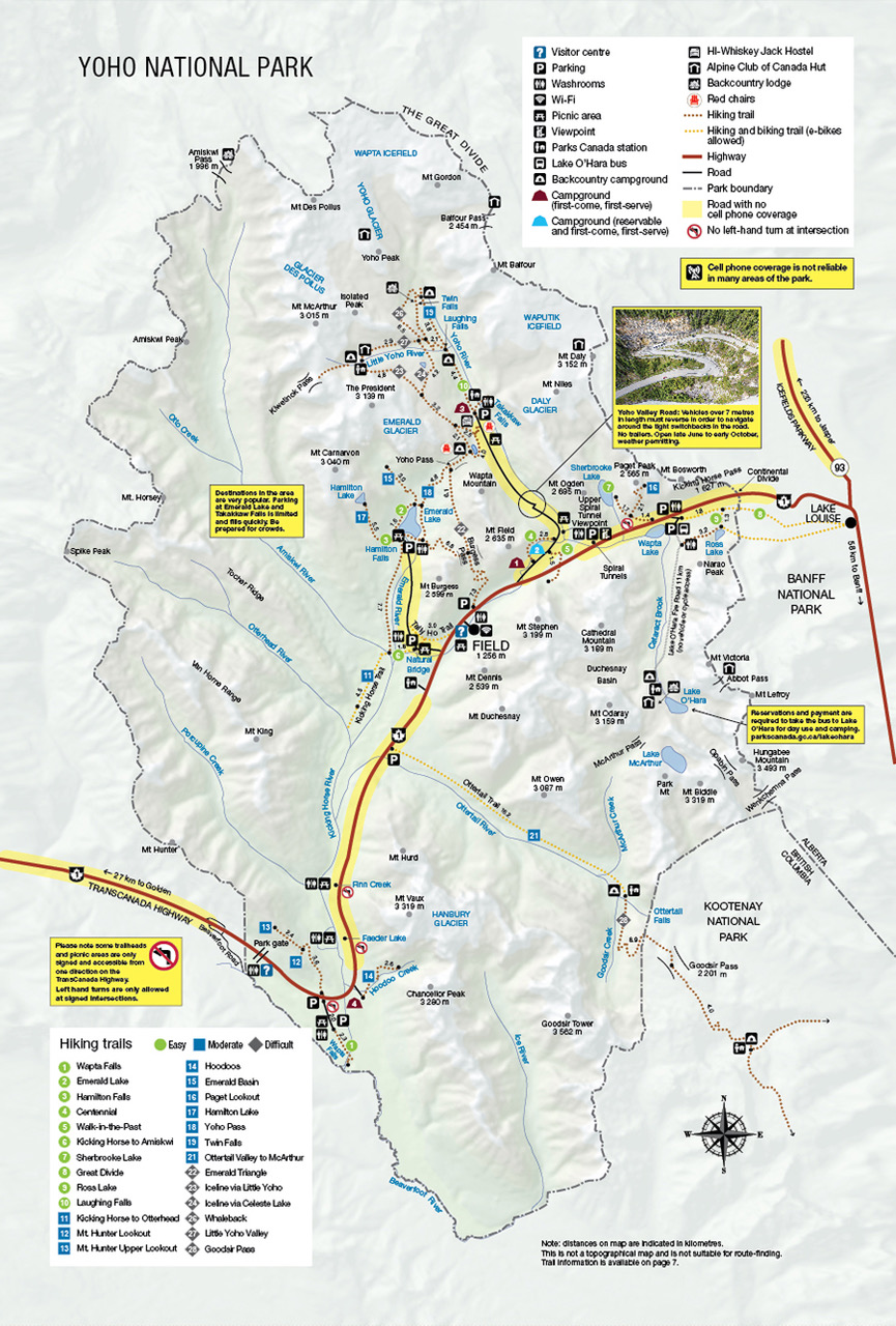
Map: Yoho National Park trail map
| Trail |
Distance (return) | Time (return) | Elevation gain |
|---|---|---|---|
 Wapta Falls Wapta Falls |
4.6 km | 1.5 hours | 30 m |
| Emerald Lake |
5.2 km | 2 hours | minimal |
| Hamilton Falls |
1.6 km | 30 minutes | minimal |
| Centennial |
2.5 km | 45 minutes | minimal |
| Kicking Horse to Amiskwi |
3.6 km | 1.5 hours | 50 m |
| Great Divide |
6 km | 2 hours | minimal |
| Ross Lake |
6.4 km | 2 hours | 100 m |
Thanks to an ongoing collaboration between Parks Canada and Google, you can now explore some Yoho National Park highlights using Street View for Google Maps.
Trail descriptions

Wapta Falls
Length: 4.6 km
Hiking time: 1.5 hours
Elevation: 30 m
Trailhead: Wapta Falls parking area, 26 km west of Field, B.C. and 32 km east of Golden, B.C. on the south side of the Trans-Canada Highway. Note: The trailhead is not marked for westbound traffic as there is no left turn lane here. Continue west for another 5.5 km to the park west boundary, turn right at the Beaverfoot exit and come back on highway 1 east. (map)
Habitat: With the ecologically important Leanchoil marsh nearby, watch for waterbirds, beavers and wolf tracks.
Description: A lush, forested walk to the base of an impressive 30 m waterfall; the largest waterfall on the Kicking Horse River.
Google Street View: Wapta Falls Trailhead
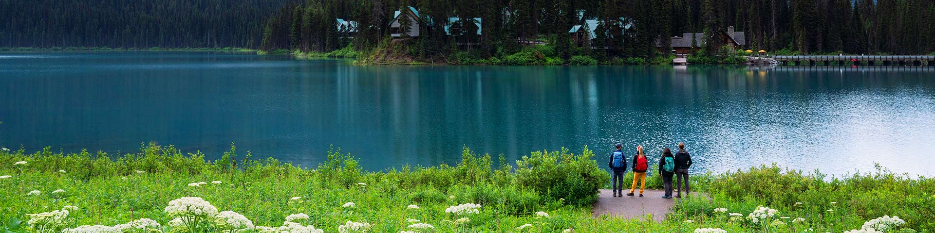
Emerald Lake
Length: 5.2 km
Hiking time: 2 hours
Elevation: minimal
Trailhead: Emerald Lake parking area, 10 km west of Field, B.C. via the Trans-Canada Highway and Emerald Lake Road. (map)
Habitat: A typical, sunny Rocky Mountain forest on the west side of the lake, and a more moist Columbian forest with cedar and hemlock on the east side.
Description: A gentle, lakeshore trail surrounded by mountain and glacier views. Includes a level, gravel path from the parking area to the bridge at the back of the lake.
Google Street View: Emerald Lake
Hamilton Falls
Length: 1.6 km
Hiking time: 30 minutes
Elevation: minimal
Trailhead: Emerald Lake parking lot entrance, 10 km west of Field, B.C. via the Trans-Canada Highway and Emerald Lake Road. (map)
Habitat: A lush, green forest typical of Yoho. Watch for hydro-power artifacts from an earlier age.
Description: A pleasant stroll to a delicate cascade.
Centennial
Length: 2.5 km
Hiking time: 45 minutes
Elevation: minimal
Trailhead: Start at the bridge at the entrance to Kicking Horse Campground, 4 km east of Field, B.C. on the Yoho Valley Road. (map)
Habitat: Part of an important wildlife corridor. Watch for mountain goats above.
Description: A shaded trail along the Kicking Horse River that is known for wildflowers.
Kicking Horse to Amiskwi
Length: 3.6 km
Hiking time: 1.5 hours
Elevation: 50 m
Trailhead: Natural Bridge parking area, 4 km west of Field, B.C. on Emerald Lake Road. (map)
Habitat: Mineral lick in the area. Watch for wildlife here at the confluence of three important valleys.
Description: Walk or cycle a forested road to a picnic site at the confluence of three rivers.
Google Street View: Natural Bridge parking area Lot
Great Divide
Length: 6 km
Hiking time: 2 hours
Elevation: minimal
Trailhead: Lake O'Hara parking lot on the south side of the Trans-Canada Highway, 13 km east of Field, B.C. (map)
Habitat: A key pinchpoint for wildlife movement. Watch for bears.
Description: Walk or cycle on a closed, paved road to the historic archway marking the location of the Continental Divide.
Ross Lake
Length: 6.4 km
Hiking time: 2 hours
Elevation: 100 m
Trailhead: Lake O'Hara parking lot on the south side of the Trans-Canada Highway, 13 km east of Field, B.C. (map)
Habitat: Typical Yoho forest, with a shallow creek crossing and marshy areas navigable by boardwalk.
Description: Start on an abandoned road and continue on a forested trail to a lake set at the headwall of Narao Peak.
Related links
- Date modified :